July 03 , 2024.
Italy / Sicily , Etna :
BULLETIN Monthly, reference month: June 2024. (issue date July 2, 2024)
SUMMARY STATEMENT OF ACTIVITY
In light of the monitoring data, it appears:
1) VOLCANOLOGICAL OBSERVATIONS: Degassing activity mainly affecting the Bocca Nuova Crater and secondarily the South-East Crater. From June 13/14 Strombolian activity in the Voragine crater and intra-crater lava emissions.
2) SEISMOLOGY: Low seismic activity due to fracturing. Average amplitude of the volcanic tremor at low level until June 23; progressive increase over the following days until reaching high values at the end of the month.
3) INFRASOUND: Weak infrasound activity, with sources mainly located in correspondence with the South-East Crater.
4) GROUND DEFORMATIONS: During the last month of observation, the ground deformation monitoring networks did not record any significant changes.
5) GEOCHEMISTRY: SO2 flux at an average level and slightly increasing since the second half of June
The CO2 flow is stable, at average values
The partial pressure of dissolved CO2 does not show significant variations
The helium isotopic ratio is high.
6) SATELLITE OBSERVATIONS: Satellite-observed thermal activity in the summit area was generally low to moderate with isolated high-level thermal anomalies corresponding to effusive activity.
7) OTHER OBSERVATIONS: The magma which fueled the first days of the Strombolian activity of Voragine has a much more evolved composition (i.e. less primitive) than that emitted by the last paroxysm of the South-East Crater December 1, 2023; this suggests that, in the first half of 2024, the volcano’s superficial magma reservoir was little or not supplied by recharges of deeper magma. Further analysis on more recent samples is underway to check for any changes in magma composition over time.
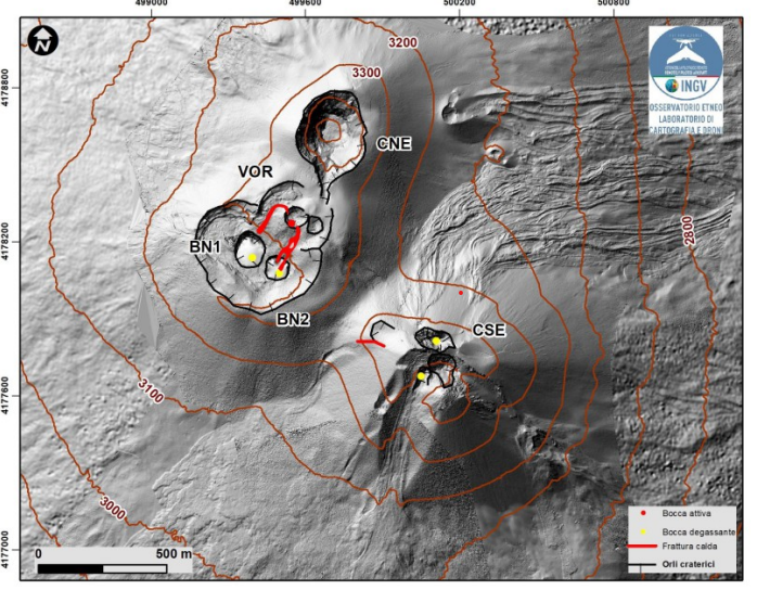
Shaded model of the terrain of the summit craters of Etna obtained thanks to the processing of drone images acquired during several overflights (June, July and September 2023), superimposed on the shaded model from the images of the Pléiades of August 22, 2020. CSE = Crater South-East, CNE = North-East Crater, BN = Bocca Nuova, VOR = Voragine. The map schematically shows in red the lava flows generated by the eruptive activity of the Voragine Crater.
VOLCANOLOGICAL OBSERVATIONS
During the observation period, the monitoring of the volcanic activity of Etna was carried out through the analysis of images from the surveillance camera network of the National Institute of Geophysics and Volcanology, Osservatorio Etneo ( INGV-OE) and through inspections in the summit area and aerial surveys. with drones made by INGV-OE staff.
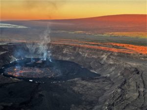
During the month of June, the degassing activity of the summit craters was mainly supported by the Bocca Nuova crater and secondarily by the Southeast crater as in the previous period (see Rep. N. M5/2024 ETNA) . In particular, the degassing of the Bocca Nuova crater is characterized by a variable regime, sometimes impulsive, with emission of gas at high temperature which fuels lightning visible at night. Rarely, episodic emissions of slightly reddish ash are observed which disperse quickly in the summit area. The degassing of the Southeast crater is produced by a fumarolic zone present in the eastern sector of the cone, by the pit crater of April 2, 2024 located on the northern edge of the crater, and by the eastern vent which was characterized by the low ash emissions generated between June 6 and 9. The Northeast crater is, however, only affected by weak fumarolic activity in an area of the northwest inner wall.
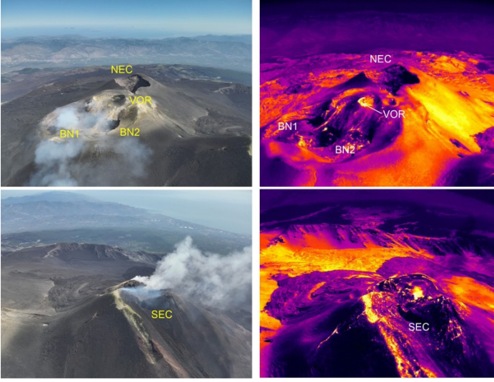
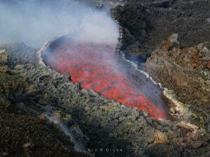
Aerial drone shot from June 18. Above, visible and thermal panoramic image of the Bocca Nuova craters (BN1 and BN2) of the North-East Crater (NEC) and the Voragine crater (VOR) characterized by a thermal anomaly indicated by the white arrow due to a eruptive activity. Below, visible and thermal image of the Southeast Crater (SEC).
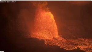
During the first half of June, the Voragine crater was, like the previous months, devoid of any activity. From June 13 and 14, weak Strombolian activity began in the southern inner wall of the scoria cone formed during the 2019-2021 activity.
Initially, the explosions occurred approximately every 10 minutes and formed a small hornitos. In the following days, the accumulation of pyroclastic material began to form a small intra-crater cinder cone, and beginning on June 26, Strombolian activity produced by two vents began to intensify. Between June 27 and 30, the new cone of slag had reached around twenty meters in height.
Beginning on June 29, a modest lava flow began from a vent on the southeast side of the new cone, which flowed into the adjacent Bocca Nuova (BN-2) crater. On July 1, 2024, a second small lava flow was generated from a vent located on the northwest flank of the new scoria cone.
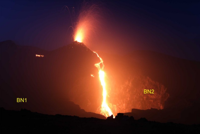
View, from the southern limit of Bocca Nuova, of the Strombolian activity of the scoria cone and the lava flow pouring into the BN2 pit crater. In addition, we observe the lava front of the lava flow generated on July 1 which is heading towards the pit crater BN1.
Seismicity:
In June, seismicity linked to fracturing processes was characterized by a low level of activity: in total, three earthquakes with a magnitude equal to or greater than 2.0 were recorded.In particular, two events with Ml between 2.1 and 2.2 were recorded on June 6 and 12.
The events were located on the southwest side of the volcano, near Monte Intraleo, at a depth of between approximately 14 and 16 km. The third event, recorded on the 16th
June (Ml=2.0), was located in correspondence with the central craters at a depth of about 1.5 km below sea level.
VOLCANIC TREMOR:
The average amplitude of the volcanic tremor, during the month of June, remained essentially at low values. From the afternoon of June 23, a gradual increase was observed until reaching high values at the end of the month. The centroid of the sources was located mainly in the Southeast Crater area, in a depth range between 2,500 and 3,000 m above mean sea level. Since the end of the month the sources have been located further north, between the South-East crater and the Central Craters.
Source et photos : INGV.
Italy , Stromboli :
WEEKLY BULLETIN, from June 24, 2024 to June 30, 2024. (issue date July 2, 2024)
SUMMARY STATEMENT OF ACTIVITY
In light of the monitoring data, it appears:
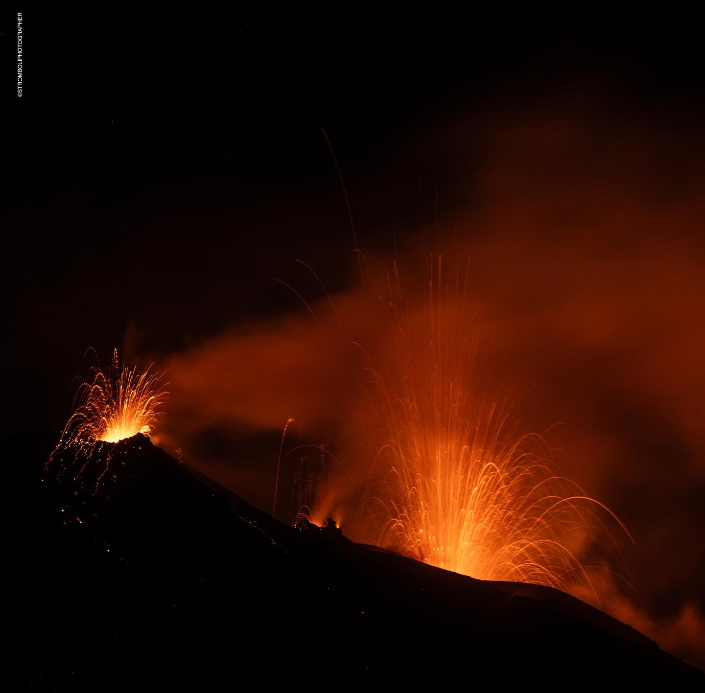
1) VOLCANOLOGICAL OBSERVATIONS: During this period, normal Strombolian activity was observed with splashing activity and lava overflow from the northern zone. The total hourly frequency was established at high values (17-24 events/h). The intensity of the explosions ranged from low to high in the North Crater area and from low to medium in the South Central Crater area.
2) SISMOLOGY: The monitored seismological parameters do not show significant variations.
3) GROUND DEFORMATIONS: The island’s ground deformation monitoring networks showed no significant changes to report for the period under review.
4) GEOCHEMISTRY: total SO2 flux in the plume at an average level
The CO2 flux in the summit zone is at average values.
The C/S ratio in the plume is at average values.
There are no updates to the helium isotope ratio in the thermal aquifer.
CO2 flow in Mofeta in the San Bartolo area: stable at high values.
CO2 flux in Scari: stable values at medium-high levels.
5) SATELLITE OBSERVATIONS: Thermal activity observed by satellite was generally low level with an isolated thermal anomaly of moderate level.
VOLCANOLOGICAL OBSERVATIONS
In the observed period, the eruptive activity of Stromboli was characterized through the analysis of images recorded by the INGV-OE surveillance cameras located at Pizzo (SPT), at altitude 190 m (SCT-SCV) and at Point dei Corvi (SPCT). . The explosive activity was mainly produced by three eruptive vents located in the northern area of the crater and by two vents located in the south central area.
A lava overflow was observed on June 28, 2024 from the northern area of the crater.
Observations of explosive activity captured by surveillance cameras
In the area of the North crater (N), with two vents located in sector N1 and one in sector N2, explosive activity of varying intensity ranging from low (less than 80 m high) to high (greater than 150 m high) was observed. Furthermore, projection activity was observed in both sectors, sometimes intense in sector N1, causing the lava overflow of June 28. The products emitted in the eruption were mainly coarse materials (bombs and lapilli). The average frequency of explosions varied between 10 and 15 events/h.
In the South-Central (CS) zone, sectors C and S1 showed no activity while the S2 explosions were of varying intensity ranging from low (less than 80 m in height) to medium (less than 150 m in height). height) emitting fine materials mixed with coarse materials. The average frequency of explosions varied between 5 and 9 events/h.
Lava overflow of June 28, 2024
On June 28 from 05:30 UTC, after intense projection activity in sector N1, a lava overflow began. Multiple flows propagated from N1 then converged in the incision dug by the pyroclastic flow of October 9, 2022 and settled along the Sciara del Fuoco. After a few hours, the energy of the event decreased and the overflow cooled around 08:45 UTC.
Source : INGV.
Photo : Stromboli stati d’animo / Sebastiano Cannavo.
Iceland , Reykjanes Peninsula:
Land uplift is faster than before the May 29 eruption
Magma flow continues beneath Svartsengi. Probability of a new magma flow and/or eruption in the coming weeks or months
Updated July 2 at 3:50 p.m.
The rate of land elevation is now higher than before the May 29 eruption.
About 13 to 19 million cubic meters left the magma chamber when the eruption began on May 29.
Probability of another magma flow and/or eruption in the coming weeks and months
Updated hazard assessment.
The rate of land rise today is higher than before the May 29 eruption and at a similar rate to earlier this year, but there have been no big changes between the events in terms of speed of land uplift. A model based on deformation data shows that the magma influx into the magma chamber beneath Svartsengi is now 4 to 6 m3/s. At the start of the magmatic intrusion and then the eruption of May 29, it is estimated that around 13 to 19 million m3 left the magma chamber. The results of the modeling calculations indicate that, based on the current influx, the magma chamber beneath Svartsengi will be in a similar position as it was before the May 29 eruption in three to six weeks. It is therefore likely that from today, a magma flow or an eruption will be triggered in the weeks and months to come.
Updated hazard assessment
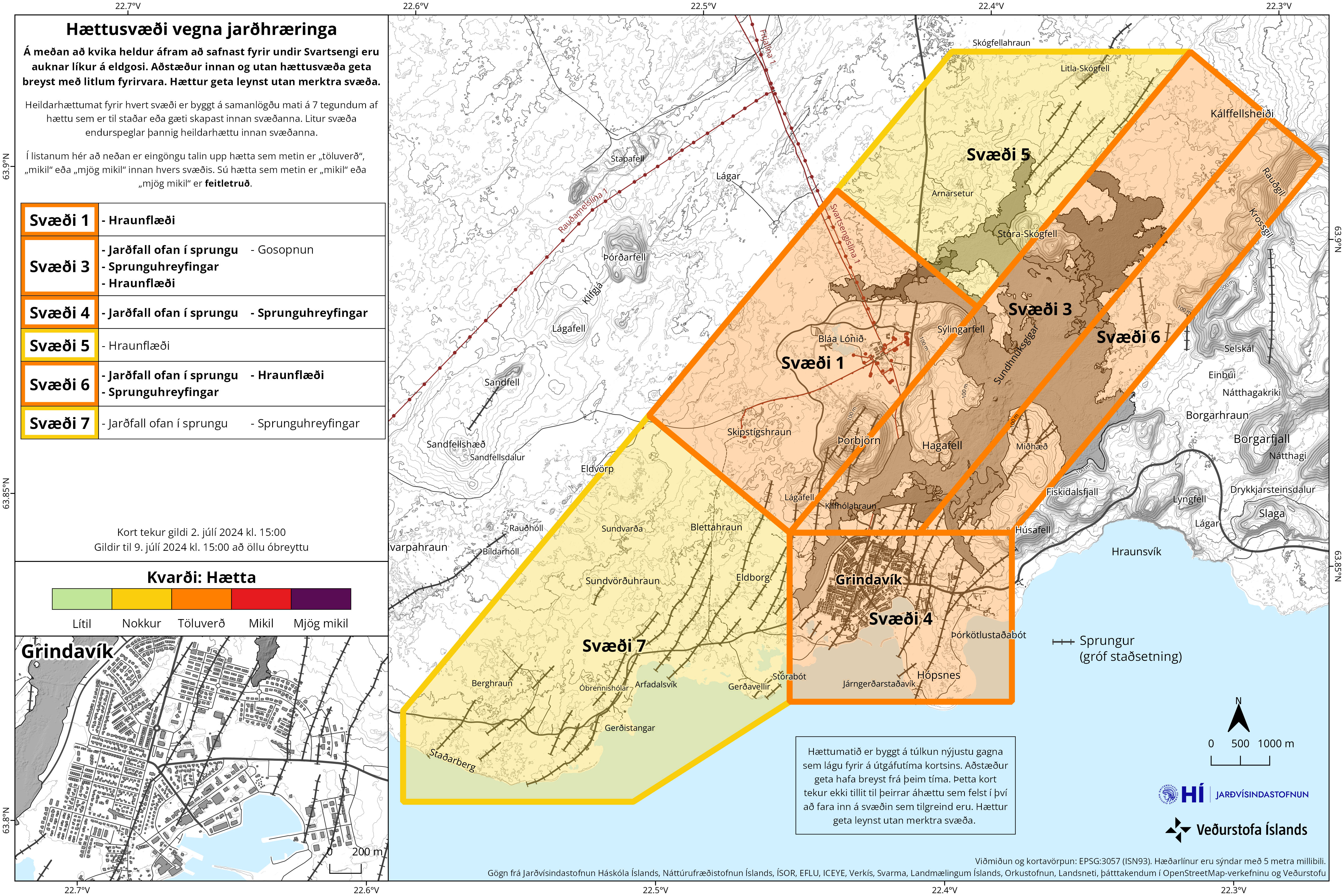
The Icelandic Meteorological Office has updated the risk assessment, which remains unchanged until July 9. Risks from lava flows and gas contamination have been reduced, but the overall risk assessment remains unchanged, with the exception of two areas. The risk level in zone 3 ranges from high (red) to considerable (orange) and in zone 5 from considerable (orange) to moderate (yellow).
Source et photo : IMO.
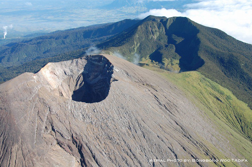
Philippines , Kanlaon :
KANLAON VOLCANO ADVISORY , 02 July 2024 , 03:30 PM
Notice of elevated volcanic SO2 gas flux at Kanlaon Volcano.
Volcanic sulfur dioxide (SO2) gas emission from the summit crater of Kanlaon based on campaign Flyspec measurements today, 2 July 2024, averaged 5,083 tonnes/day. This is the second highest emission from the volcano recorded this year and the third since instrumental gas monitoring began. Kanlaon has been degassing increased concentrations of volcanic SO2 this year at an average rate of 1,273 tonnes/day prior to the 3 June 2024 eruption, but emission since then has been particularly elevated at a current average of 3,254 tonnes/day. In addition, volcanic earthquake activity has persisted at an average of 10 events/day since the eruption. Ground deformation data from continuous GPS and electronic tilt measurements have been recording medium-term inflation of the Kanlaon edifice since March 2022 and a shorter-term inflation of the eastern flank since 2023, indicating slow but sustained pressurization within the volcano. The overall monitoring parameters indicate that magmatic processes beneath volcano may be driving current unrest, causing persistently high concentrations of volcanic gas emission, swelling of the edifice, and occasional volcanic earthquake activity.
The public is reminded that Alert Level 2 (increasing unrest) prevails over Kanlaon. This means that there is current unrest driven by shallow magmatic processes that could eventually lead to explosive eruptions or even precede hazardous magmatic eruption at the summit crater. The public is strongly advised to be vigilant and avoid entry into the four (4) kilometer-radius Permanent Danger Zone (PDZ) to minimize risks from volcanic hazards such as pyroclastic density currents, ballistic projectiles, rockfall and others. In case of ash fall events that may affect communities downwind of Kanlaon’s crater, people should cover their nose and mouth with a damp, clean cloth or dust mask. Civil aviation authorities must also advise pilots to avoid flying close to the volcano’s summit as ash and ballistic fragments from sudden eruption can be hazardous to aircraft. Communities living beside river systems on the southern and western slopes, especially those that have already experienced lahars and muddy streamflows, are advised to take precautionary measures when heavy rainfall over the volcano has been forecast or has begun.
DOST-PHIVOLCS maintains close monitoring of Kanlaon Volcano and any new development will be immediately communicated to all concerned stakeholders.
Source : Phivolcs
Photo : BongBong Woo Tadifa
Colombia , Chiles / Cerro Negro :
Weekly Activity Bulletin: Chiles Volcanic Complex and Cerro Negro (CVCCN)
Regarding the monitoring of the activity of the CHILES AND CERRO NEGRO VOLCANOES, the COLOMBIAN GEOLOGICAL SERVICE (SGC), an entity attached to the MINISTRY OF MINES AND ENERGY, reports that:
Between June 25 and July 1, 2024 and compared to the previous week, an increase was recorded both in the occurrence of seismicity and in the energy released. The predominance of seismicity associated with rock fracture within the volcanic system and the recording of seismicity linked to fluid dynamics in its internal conduits remain. Some of them have very low dominant frequencies.
Fracture earthquakes were preferentially located in two sources. The first source is located in the collapse zone located north of the summit of the Chiles volcano, at distances less than 2.5 km, with depths between 2 and 4.5 km compared to the reference height (4 700 m above sea level) and with a maximum magnitude of 3.0. The second source was located southwest of the summit of Chiles Volcano, at distances less than 4.3 km, with depths between 3 and 7 km and a maximum magnitude of 1.7. The event recorded on June 25 at 7:05 a.m. stands out, with a magnitude of 3.0 and located 1.6 km north-northeast of the summit of Chiles volcano.
The evolution of activity beneath the CVCCN is the result of internal processes derived from the complex interaction between the magmatic system, the hydrothermal system and the geological faults of the area. Therefore, the probability of the occurrence of energetic earthquakes that can be felt by residents in the region of influence of the CVCCN persists.
Volcanic activity remains in a YELLOW ALERT state: active volcano with changes in the behavior of the base level of monitored parameters and other manifestations.
Source et photo: SGC