July 02 , 2024.
United States , Yellowstone :
Monday, July 1, 2024, 12:32 PM MDT (Monday, July 1, 2024, 18:32 UTC)
44°25’48 » N 110°40’12 » W,
Summit Elevation 9203 ft (2805 m)
Current Volcano Alert Level: NORMAL
Current Aviation Color Code: GREEN
Summary
Yellowstone caldera activity remains at background levels, with 72 located earthquakes in June (maximum = M2.5). Deformation measurements indicate a pause in subsidence (which has been ongoing since 2015) due to seasonal changes in snowmelt and groundwater conditions.
Recent Work and News
Steamboat Geyser did not erupt in June, although small minor eruptions have been occurring since the middle of the month, suggesting that a major eruption will occur in the coming weeks.
June field work by members of the Yellowstone Volcano Observatory consortium included maintenance of monitoring equipment and geologic mapping. July will see continued work, especially related to mapping the products of Yellowstone’s most recent caldera-forming eruption, which occurred 631,000 years ago.
Seismicity
During June 2024, the University of Utah Seismograph Stations, responsible for the operation and analysis of the Yellowstone Seismic Network, located 72 earthquakes in the Yellowstone National Park region. The largest event of the month was a micro earthquake of magnitude 2.5 located about 8 miles north of Lake in Yellowstone National Park on June 10 at 9:29 AM MDT.
June seismicity in Yellowstone was marked by one swarm of 29 earthquakes that occurred June 6–9 and was located about 9 miles north-northeast of West Yellowstone, Montana. The largest earthquake in the sequence was a magnitude 1.5 on June 7 at 6:19 PM MDT.
Earthquake sequences like these are common and account for roughly 50% of the total seismicity in the Yellowstone region.
Yellowstone earthquake activity is currently at background levels.
Ground Deformation
During the month of June, continuous GPS stations in Yellowstone caldera showed little deformation, probably reflecting the onset of the annual summertime pause in subsidence (ongoing since 2015), which is caused by seasonal changes related to snowmelt and groundwater conditions. The caldera has subsided by about 3 cm (1.2 in) since the end of September 2023. A slight amount of subsidence (about 1 cm, or 0.4 in) has occurred at Norris Geyser Basin over the past four months.
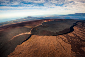
Source : YVO
Photo : Ear Spring, in Upper Geyser Basin. USGS / Mike Poland, May 23, 2024
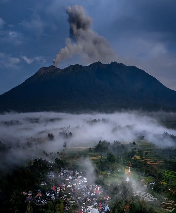
Indonesia , Marapi :
The series of non-continuous eruptions continued until June 28, 2024, but with a fluctuating downward trend. The development of Mount Marapi activities until July 1, 2024 can be translated as follows:
Visually, during the last week (June 23-30, 2024), Mount Marapi was clearly visible until it was covered in fog. White to gray smoke was observed coming from the main crater with light to thick intensity at a height of approximately 100 to 300 meters above the summit.
In terms of seismicity, between June 23 and 30, 2024, earthquakes on the Marapi were dominated by emissions earthquakes, while eruption/explosion earthquakes were recorded at low levels. Comprehensive seismic data recorded 2 eruption earthquakes, 26 emissions earthquakes, 2 shallow volcanic earthquakes, 6 deep volcanic earthquakes, 25 local tectonic earthquakes, 17 distant tectonic earthquakes and continuous tremors with an amplitude of 0.5 to 2 mm (dominant value 1 mm).
Over the past two weeks, eruption/explosion earthquake activity has been relatively low.
The dv/v value (seismic velocity variation) from Marapi seismicity data up to June 30, 2024 shows that it is close to zero, which is interpreted to mean that the stress level or pressure on the volcanic body returned to normal conditions (no increase in stress). Likewise, the coherence value, which reflects the state of the underground environment, now has a high value (about 0.8), which indicates that the state of the environment near the surface of the body of Mount Marapi has returned to the normal. Before the January 2023 and December 2023 eruptions, the dv/v and coherence values had decreased.
In terms of deformation, the graphical data from the inclinometer (Batupalano station) still continues its downward trend (deflation) both on the tangential and radial axes, which indicates a tendency of subsidence of the body of Mount Marapi.
Using remote sensing (satellite), the emission rate (flux) of SO2 gas from Marapi, which can also indicate the supply of magma at depth, generally shows a decline and is relatively stable at small quantities below 300 tonnes /day since the beginning of May. 2024.
Based on the evaluation of visual, instrumental and remote sensing (satellite) data, Marapi activity generally shows a decreasing trend and is relatively stable, especially over the last two weeks. However, the potential for an eruption still exists, that is, the release of remaining energy to reach a state of equilibrium.
If there is no increase in magma input, the eruption that could occur is estimated to be small scale with a potential danger of ejection of eruptive material around the summit of Mount Marapi within a radius of 3 km from the activity center (Verbeek crater). .
The distribution of eruption ash can occur depending on wind direction and speed. However, eruption materials fallen and deposited on the summit and slopes of Marapi still have the potential to turn into a lahar when mixed with rainwater. Therefore, the potential danger of lahar flows/floods in the valleys/ravines/river flows originating at the summit of Mount Marapi persists. Likewise, the potential for danger from toxic volcanic gases such as CO2, CO, SO2 and H2S gases remains in the Mount Marapi crater/summit area.
Based on the results of a comprehensive analysis and assessment, from July 1, 2024 at 3:00 p.m. WIB, the activity level of Mount Marapi was lowered from level III (SIAGA) to level II (WASPADA).
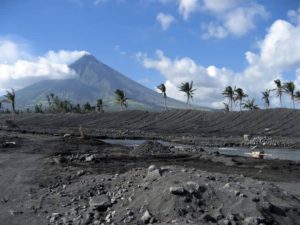
Source : PVMBG
Photo : Sumatera Barat Indonesia
La Réunion , Piton de la Fournaise :
Seismicity
In June 2024, the OVPF-IPGP recorded a total of:
• 19 superficial volcano-tectonic earthquakes (0 to 2.5 km above sea level) under the summit craters;
• 0 deep earthquakes (below sea level);
• 9 long-period earthquakes;
• 337 landslides.
The month of June 2024 will have been marked by low seismicity under the Piton de la Fournaise with only 19 superficial volcano-tectonic earthquakes and no deep earthquakes recorded.
Only 5 superficial volcano-tectonic earthquakes could be located under the Dolomieu crater. The others – of lower magnitudes – could not be located.
Numerous (337) landslides in the Dolomieu Crater, at Cassé de la Rivière de l’Est and at Piton de Crac were also recorded.
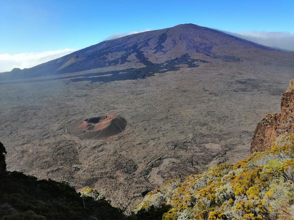
Deformation
After a recovery in February 2024, the inflation of the building stopped at the beginning of April 2024. A slight deflation of the summit zone was then recorded in April and May. In June 2024, no significant deformation was observed.
Gas geochemistry
Following the cyclonic event of January 15, 2024, a rapid increase has been observed since January 19 both in the distal and near field. This increase is confirmed in May 2024 and CO2 emissions have reached unusually high values at the proximal GITN station. A decrease on all sites has been recorded since May 2024.
Balance sheet
Since April 2024, magma replenishment and pressurization of the surface reservoir have ceased.
As of June 2024, seismicity remained low – with only 19 shallow volcano-tectonic earthquakes recorded beneath the summit craters.
Note that since 2016, the replenishment of the superficial magmatic reservoir under the Piton de la Fournaise has taken place in pulses, thus such phases of calm in deformations and seismicity have already been observed on several occasions between 2016 and 2023 over periods ranging from 15 days to several months.
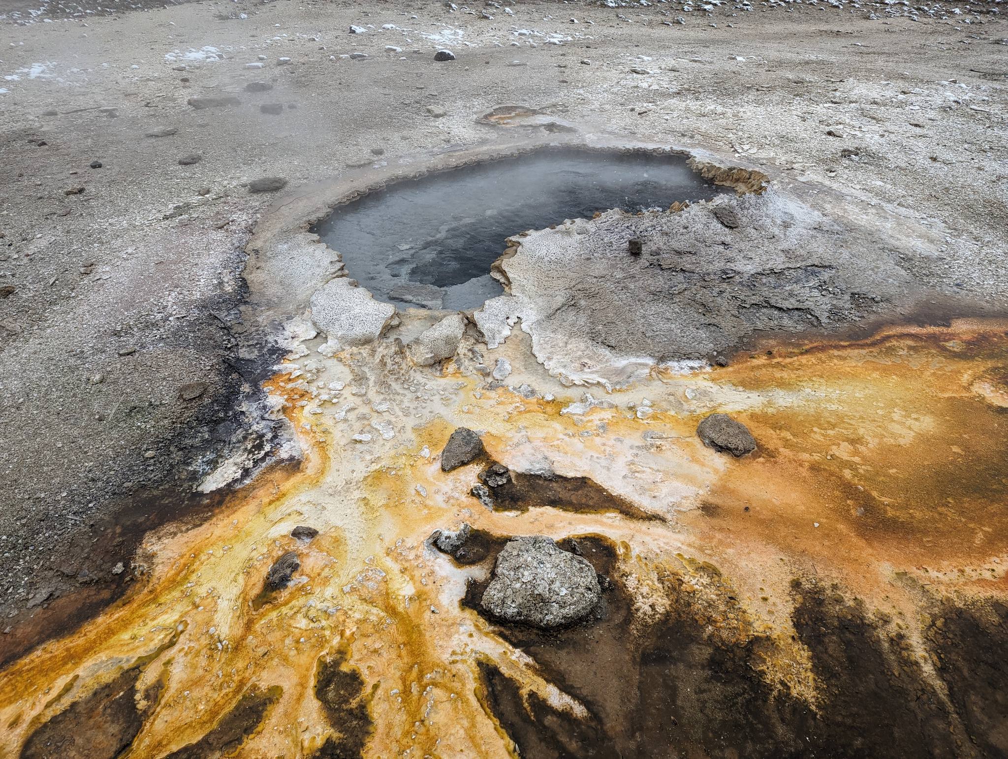
Source : OVPF
Photo : Nath Duverlie
Indonesia , Ibu :
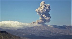
An eruption of Mount Ibu occurred on Monday July 1, 2024 at 08:39 WIT with the height of the ash column observed at ± 3000 m above the summit (± 4325 m above sea level). The ash column was observed to be gray to black in color with thick intensity, oriented towards the South-West and West. This eruption was recorded on a seismograph with a maximum amplitude of 28 mm and a duration of 175 seconds.
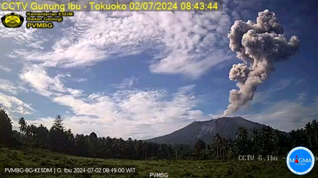
VOLCANO OBSERVATORY NOTICE FOR AVIATION – VONA
Issued : July 01 , 2024
Volcano : Ibu (268030)
Current Aviation Colour Code : ORANGE
Previous Aviation Colour Code : orange
Source : Ibu Volcano Observatory
Notice Number : 2024IBU045
Volcano Location : N 01 deg 29 min 17 sec E 127 deg 37 min 48 sec
Area : North Maluku, Indonesia
Summit Elevation : 4240 FT (1325 M)
Volcanic Activity Summary :
Eruption with volcanic ash cloud at 23h39 UTC (08h39 local).
Volcanic Cloud Height :
Best estimate of ash-cloud top is around 13840 FT (4325 M) above sea level or 9600 FT (3000 M) above summit. May be higher than what can be observed clearly. Source of height data: ground observer.
Other Volcanic Cloud Information :
Ash cloud moving to west. Volcanic ash is observed to be gray to dark. The intensity of volcanic ash is observed to be thick.
Remarks :
Eruption recorded on seismogram with maximum amplitude 28 mm and maximum duration 175 second.
Source et photo : Magma Indonésie.
Alaska , Shishaldin :
Minor unrest at Shishaldin Volcano continues, with small, low-frequency earthquakes and seismic tremor occurring over the past day. At times of low wind, minor infrasound signals are detected, possibly indicative of very small explosions occurring deep in the volcanic conduit. Nothing noteworthy was observed in cloudy satellite views of the volcano over the past day. Web camera views of the volcano have been obscured by fog.
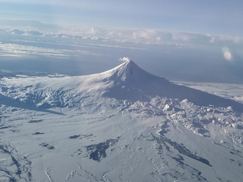
Images of the north side of Shishaldin Volcano on February 20, 2024 from a passing flight showing light steaming from the summit and a snow-free area over cooling deposits on a northeast drainage.
Minor rock falls associated with gravitational collapse of the unstable ground in and near the summit crater may occur. The collapse events can generate small clouds of dust likely composed of fine-grained ash. The diffuse dust clouds dissipate quickly and can produce irregular-shaped deposits near the summit. The last significant ash-producing eruption occurred in November 2023.
Local seismic and infrasound sensors, web cameras, and a geodetic network are used to monitor Shishaldin Volcano. In addition to the local monitoring network, AVO uses nearby geophysical networks, regional infrasound and lighting data, and satellite images to detect eruptions.
Source : AVO
Photo : Beesley, Nick