January 14 , 2022.
Indonesia , Merapi :
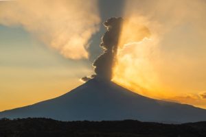
The growth of the lava dome of Mount Merapi.
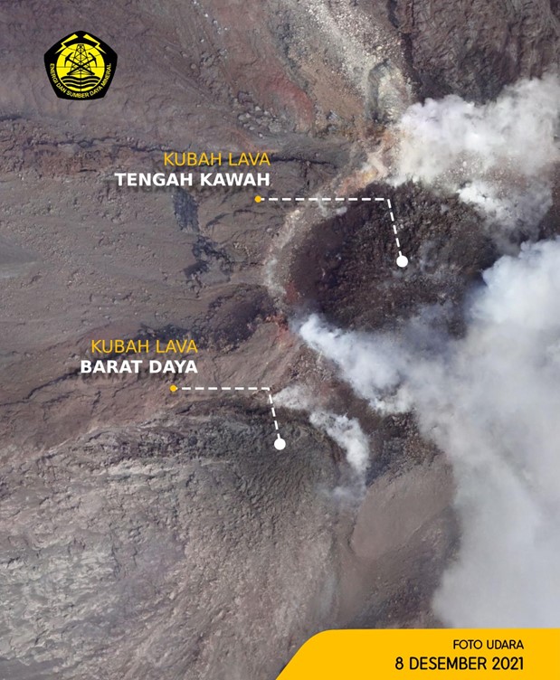
Mount Merapi erupted into an effusive eruption on January 4, 2021. Effusive eruption activity in the form of lava dome growth, hot cloud formation, and lava fall. Unlike previous Merapi effusive eruptions, this 2021 eruption has 2 eruption centers, namely in the southwest lava dome and the central lava dome of the crater.
These two lava domes continue to grow. As of January 7, 2022, the volume of the southwest lava dome is 1,670,000 m3 and the central lava dome is 3,007,000 m3. The growth rate of the southwest lava dome is 5,700 m3 / day and the rate of the central lava dome is relatively fixed. Based on data on the volume of the lava dome, a model was made of the release of hot avalanche clouds to map the potential hazards.
The modeling results showed that if the volume of the southwest lava dome was 3 million m3, a landslide would cause hot clouds to fall in the Boyong, Bebeng, Krasak and Putih rivers up to a maximum of 5 km. For the central lava dome, if the volume was 1 million m3, then the hot cloud avalanche would reach a distance of 5 km towards the Gendol River.
Source : BPPTKG.
La Réunion Island , Piton de la Fournaise :
Press release of January 14, 2022 – 10:45 a.m.
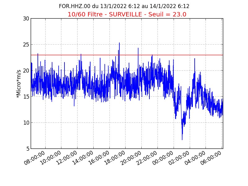
The eruption that began on 12/22/2021 at around 3:30 a.m. local time continues. Over the last 24 hours, the amplitude of the tremor has been relatively stable, with a slight decrease over the last 6 hours.
The fluctuations in the amplitude of the tremor are linked in part to the level of the lava lake, which varies depending on the mode of degassing, the erosion of the eruption duct and the sporadic openings of the tunnels which allow emptying of the cone. The openings in the tunnels generate a drop in pressure at the cone and within the tunnels, and consequently a drop in the amplitude of the tremor.
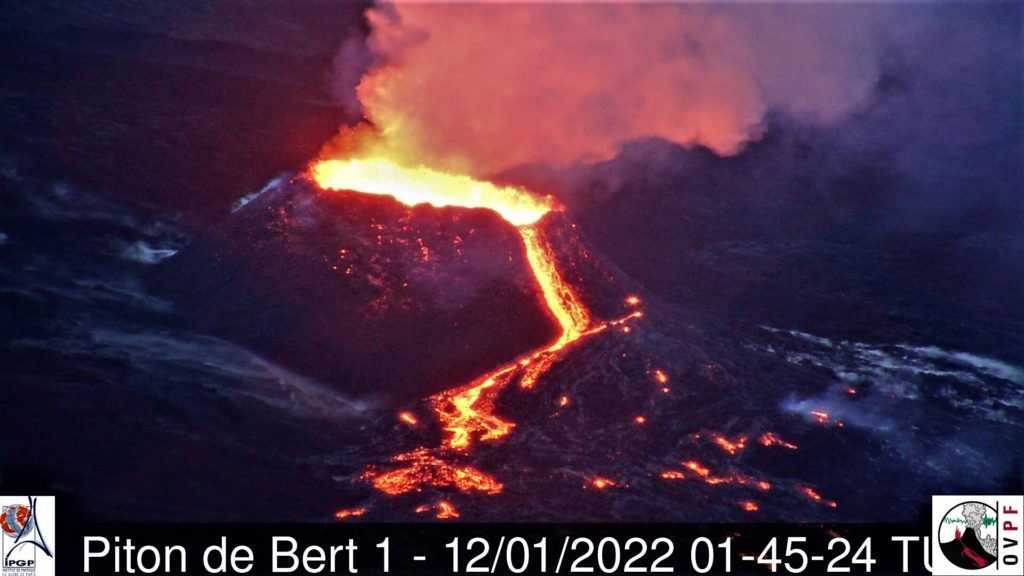
Bad weather conditions persist on the eruptive site. However this morning a relatively high cloudy ceiling allowed some observations. These show that the lava projections at the level of the cone are always present and occasionally exceed the height of the cone. Regularly overflows of the lava lake are observed as well as numerous resurgences of lava flows at the roof of the field in lava tunnels downstream of the cone.
The front of the last flow arm, set up along the southern rampart of the Enclos Fouqué for several days, is progressing very slowly given the relatively low slopes in the area.
Over the last 24 hours:
– The surface deformations still show a deflation at the level of the summit zone, linked to the emptying of the magma reservoir located under the summit (at about 2-2.5 km deep) feeding the eruptive site.
– 33 volcano-tectonic earthquakes, of low magnitude (<1), were recorded under the summit. This seismicity is linked to the emptying of the magma reservoir located under the summit, weakening its roof.
– Due to the very bad weather conditions on the eruptive site, only one estimate of the lava flows could be made over the last 24 hours by satellite method with the HOTVOLC platform (OPGC – Clermont Auvergne university) (acquisitions being made every 15 minutes). This flow was estimated at 4 m3 / s.
Alert level: Alert 2-1 (eruption in the Enclos )
Source : OVPF
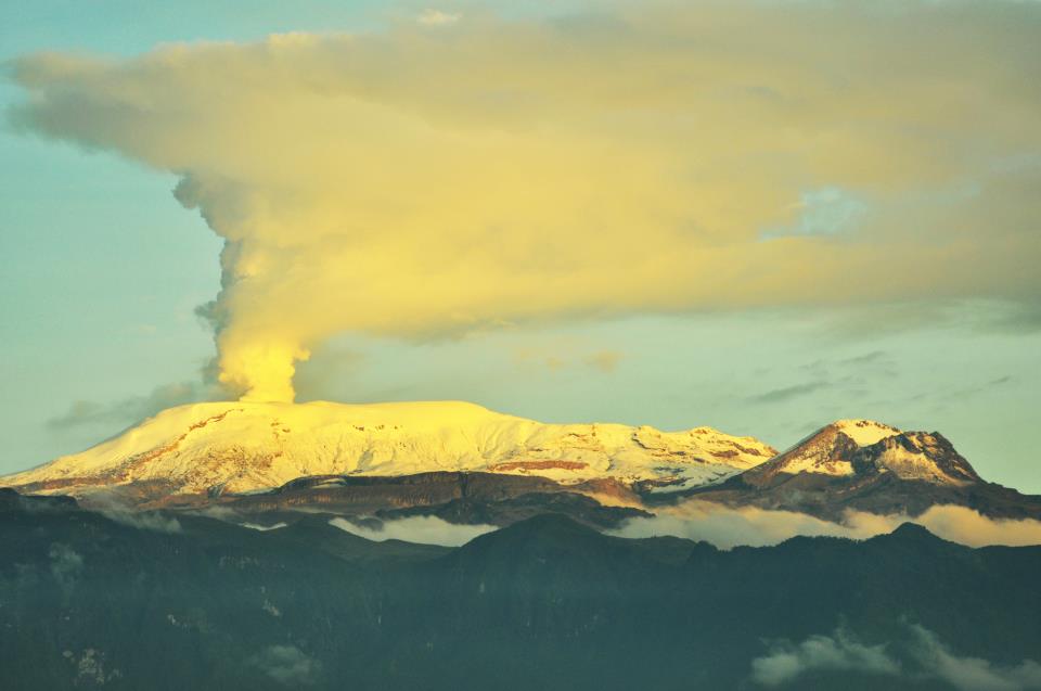
Colombia , Nevado del Ruiz :
Weekly activity bulletin of the Nevado del Ruiz volcano
The activity level continues at: Yellow activity level or (III): changes in the behavior of volcanic activity.
Regarding the monitoring of the activity of the Nevado del Ruiz volcano, the SERVICIO GEOLÓGICO COLOMBIANO reports that:
Seismicity related to fluid dynamics inside volcanic conduits showed an increase in the number of recorded earthquakes and released seismic energy, compared to the previous week. This seismic activity was characterized by the appearance of continuous volcanic tremor, tremor pulses, long and very long period earthquakes, which presented moderate energy levels and variable spectral content. These earthquakes were located mainly in the Arenas crater and its surroundings. Some of these signals were associated with ash emissions, confirmed by the cameras installed in the area of the volcano and by the report of the officials of the Los Nevados National Natural Park.
The seismicity generated by the fracturing of the rock increased in number of earthquakes and in seismic energy released, compared to the previous week. This seismic activity was located mainly in the South-East, North-West sectors and in the Arenas crater of the volcano, as well as to a lesser extent in the South-West sectors and its surroundings. The depth of the earthquakes varied between 0.5 and 7.7 km. The maximum magnitude recorded during the week was 1.8 ML (Local Magnitude) corresponding to two earthquakes recorded on January 7 at 08:16 and 08:17 (local time), located 2.6 km southeast of the Arenas crater, at depths of 3.6 and 3.8 km, respectively.
Source : SGC.
Photo : Auteur Inconnu.
Tonga Island , Hunga Tonga-Hunga Ha’apai :
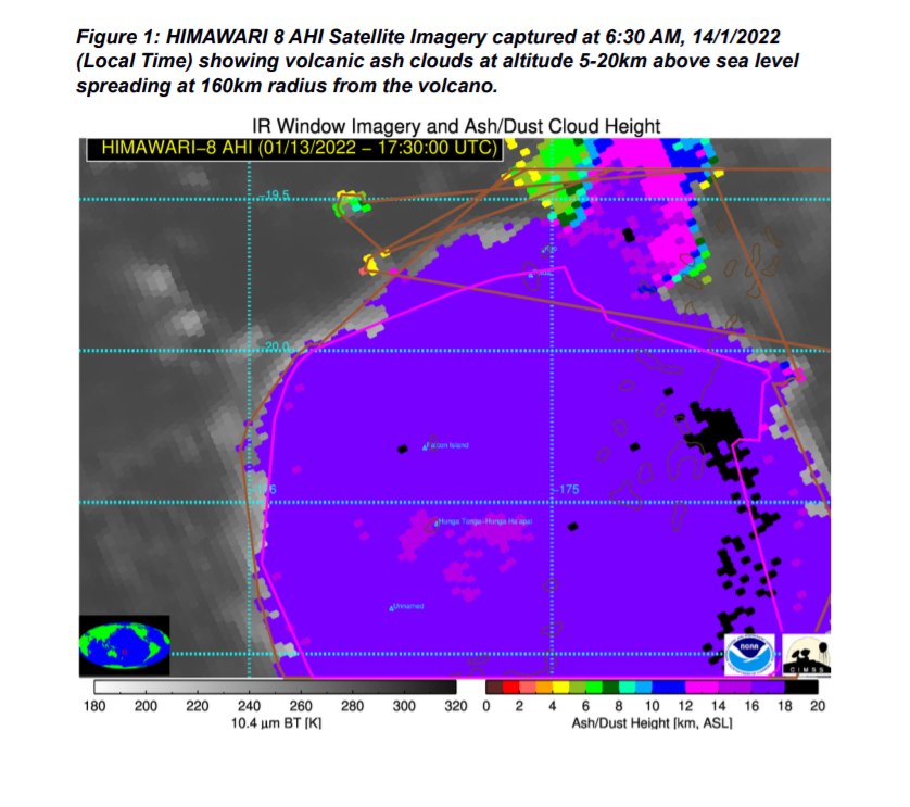
This is a Public Notice from the Tonga Geological Services monitoring the Hunga-Tonga-Hunga-Ha’apai (HTHH) Eruption issued at 9:50 AM, 14/1/2022.
Observations of satellite images captured since 4:20 AM this morning 14/01/2022 are as follows.
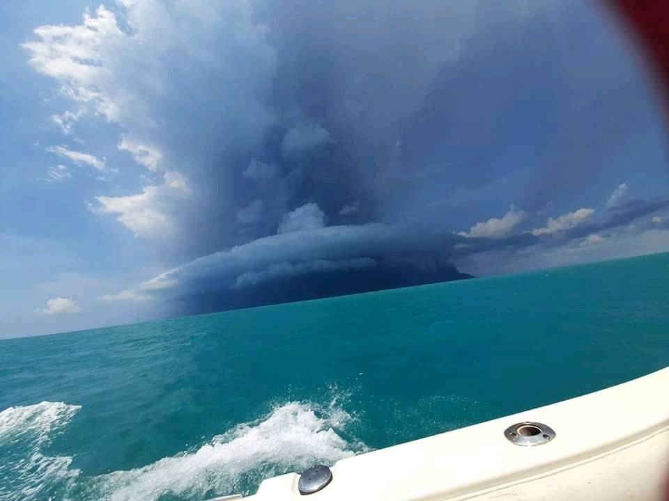
Hunga Volcano erupted at 4:20 AM this morning, raising the plume to altitude 5-20km above sea level. The plume of ash, steam and gas dispersed at a radius of 210km from the volcano over Tongatapu, ‘Eua and Ha’apai group .
Smell of sulphur is reported in Tongatapu and ‘Eua. It is advised to wear masks when commuting.
Volcanic ash may not be noticeable or visible in the air. If you feel stingy on the eyes or irritation are signs of ash in the air. If dark coloured particles are observed on outdoor surfaces at a large scale, it may also be a sign of ashfall. It is advised to stay indoors and to protect your rainwater harvestings.
Please advise local authorities if any abnormal activity occurs or contact 7401331. The notice will be issued at 12:30 PM later today,
Underwater volcano Hunga-Tonga-Hunga-Ha’apai has erupted again, sending ash, steam and gas 20km into the air.
There is a tsunami warning in place for all the islands of the Kingdom of Tonga as the volcanic activity affects coastal water levels. People are advised to stay out of the water and away from the coast.
The maximum tsunami wave was recorded by the Nuku’alofa tide gauge at 12.30pm and was about 30cm, and sea level fluctuation has been observed.
Changes to seawater levels have also been detected on the south coast of Samoa as a result of this morning’s eruption.
Sources : Tonga Geological Services , nzherald.co.nz .
Photos : Ioana Kalo Sugar. Himawari 8.
Ecuador / Galapagos , Wolf :
Update on the activity of the Wolf volcano – Isabela Island, Galapagos archipelago
Summary :
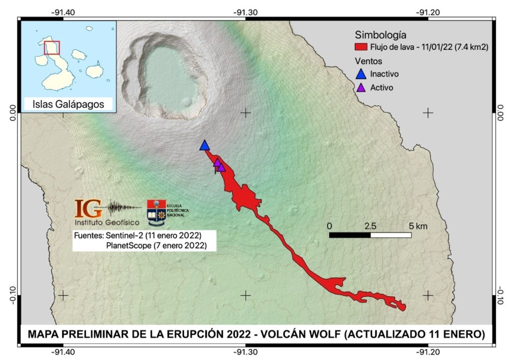
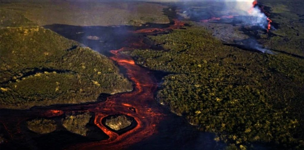
The Wolf volcano (height: 1710 m above sea level) located in the northern part of Isabela Island in the Galapagos archipelago, began a new eruptive phase at 11:20 p.m. on January 6, 2022, Galapagos time (12:20 a.m. on January 7 2022, Continental Ecuador Time). The evolution of this eruption was followed by seismic stations and various satellite systems, thanks to which it was possible to verify mainly the emission, the advance of the lava flows and the gas columns. The deformation data analyzed up to January 5 (date of the last image of the Sentinel-1-ESA constellation), revealed a significant deformation before the eruption of January 6 on Isabela Island of the archipelago of Galapagos. The lava flows were emitted by at least 3 cracks located on the south-eastern flank of the volcano, and reached a maximum distance of approx. 16.5 km, without reaching the coastal margin (Fig. 1. updated on January 11, 2022), and they covered an approximate area of 7.4 km2.
Hundreds of satellite thermal alerts have been recorded daily in relation to these lava flows, which have gradually diminished in recent days, which can be interpreted as a decrease in the rate of lava emission, or their gradual cooling. Likewise, the degassing of sulfur dioxide (SO2) estimated by satellite systems has decreased considerably, from 60 thousand tons on January 07, 2022 to 8.1 thousand tons on January 12, 2022. The internal activity of the volcano recorded by the The nearest seismic sensors (Station FER01 – Volcan Fernandina) shows a slightly downward trend. All this allows us to conclude that both internal and surface activity of the Wolf volcano is on a downward trend as of the publication date of this report. However, a rebound in eruptive activity cannot be ruled out, like what happened during the 2015 eruption.
Satellite images
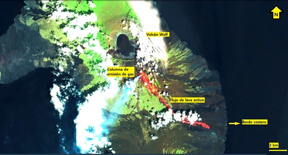
Thanks to satellite images (GOES-16), it was possible to observe the evolution of the eruptive activity of the Wolf volcano. This eruption is characterized by the emission of lava flows and volcanic gas emission columns through a radial fissure on the south-eastern flank.
Sentinel-2 satellite image of January 11, 2022. In the image, we observe a column of gas directed towards the southwest, as well as the thermal trace (IR) of the active lava flow emitted by the southeast flank of the Wolf volcano.
Lava flows
The lava flows were emitted through at least 3 cracks located between the altitude of 1290 m (active vent on January 7) to 1090 m (elevation of the active vent on the date of issue of this report). ) on the south-eastern flank of the volcano. Lava flows reached an extension of approximately 16.5 km from the highest vent and covered an area of approximately 7.4 km2. In addition, it was possible to observe fires produced by the high temperatures of the lava flows interacting with the vegetation of the area. During its course, the flow changed direction for approximately 11.6 km along the slope, taking a course towards the coastal margin. However, the distance from the front of the lava flow to the sea until January 11, 2022 is about 3 km in a straight line.
Degassing (VAAC and SO2 alerts detected)
The volcanic gas emission columns dispersed mainly to the southwest, with the exception of January 7, where they moved west and northeast. The ash alerts issued by the Washington VAAC associated with these gas columns were not generated until January 7 and 8. The reported heights went from 2,600 meters above the vent on January 7 to 300 meters on January 8, and then went unnoticed; which implies that the intensity of emissions has decreased. It should be noted that there are no populations near the volcano or towards the eruptive columns. In addition, satellite systems have made it possible to obtain data on the outgassing of sulfur dioxide (SO2) associated with the eruption of the Wolf volcano. The SO2 values detected by the Mounts system fell from 60,000 tonnes on January 7 to 8,100 on January 12, indicating a decrease in the surface activity of the volcano, as recorded by other satellite systems.
Source : IGEPN.
Photos : IGEPN , Diario Libre

