November 06 , 2019.
Chile , Nevados of Chillan :
Volcanic Activity Report (RAV) Volcanological Observatory of the South Andes – Ovdas. Region of Ñuble. Publication date : November 5, 2019 16h00.
Current Alert Level: ORANGE.
Seismic activity:
In the past 24 hours, the CVNCh monitoring network has recorded volcano-tectonic (VT), long-period (LP), tremor (TR) and very long-period type (VLP) seismicity. releasing seismic energy at moderate levels. This LP seismicity is frequently related to the occurrence of explosions (EX), which cause surface activity.
Observations:
The higher energy VT earthquake was located 4 km southeast (SE) of the active crater, with a depth of 3.3 km.
During the day and when weather conditions permitted, there was a greater recurrence of explosive activity, with pulsatile emission of gases and particulate matter. Similarly, during the night, it was possible to observe explosions with projection of incandescent volcanic materials around the active crater.
Other remarks:
The GNSS station network, which detects changes in the CVNCh deformation, records an elongation rate in the control lines crossing the active crater of 0.7 ± 0.06 cm in the last 30 days, while keeping rates similar to last week During this period, the increase continues in all monitoring stations. The vertical lift rate for the last 30 days is 1.9 ± 0.3 cm / month, at the closest station to the active crater (1.5 km). The vertical rise accumulated in this station is 6.3 cm ± 0.2 cm.
The MIROVA group reported thermal anomalies, with a maximum power of 27 MW, located on the active crater.
Infrasound sensors recorded explosion-related signals (EX) with a maximum value of 2.6 Pa reduced to 1 km.
Source : Sernageomin.
Photo : losandes.com.ar.
Mexico , Popocatepetl :
November 05, 11:00 am (November 05, 16:00 GMT)
According to the monitoring systems of the Popocatepetl volcano, 96 exhalations were identified, accompanied by gas and light amounts of ash, as well as two moderate explosions at 11:07 and 22:19 which generated a column of 1.5 km and emitted incandescent materials and four more explosions at 17:24, 21:49, 22:27 and 00:09 today. In addition, a volcano-tectonic earthquake with a preliminary magnitude of 1.9 and 148 minutes of tremor was recorded. During the night, no glow was observed.
At the time of writing, there has been a slight steady emission of water vapor and volcanic gases. Any emission containing ashes will be dispersed towards the West-South-West.
Updated November 05 at 15:00 (November 05 at 21:00 GMT).
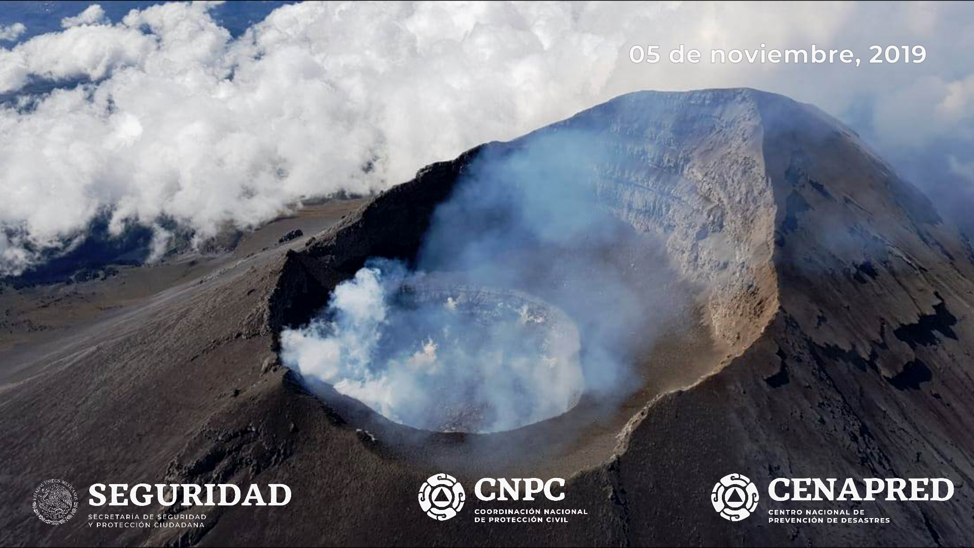
On November 5th, with the support of the National Guard, a reconnaissance flight was made in the crater of the Popocatépetl volcano. During this overview, specialists from the National Center for Disaster Reduction (CENAPRED) of the National Coordination of Civil Protection and researchers from the UNAM Institute of Geophysics were able to observe the formation of the dome no. a diameter of 210 m and 80 m thick, with an irregular surface. The inner crater has a diameter of 350 m and an approximate depth of 90 m.
CENAPRED urges NOT to approach the volcano and in particular the crater because of the risk of falling ballistic fragments, and in case of heavy rains to stay away from the bottom of the ravines due to the risk of mudslides and debris.
The warning light of Popocatépetl is in YELLOW PHASE 2.
Source : Cenapred .
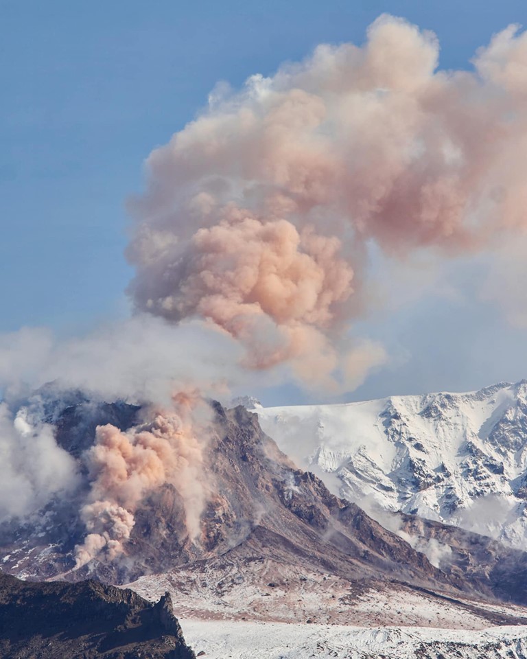
Kamchatka , Sheveluch :
VOLCANO OBSERVATORY NOTICE FOR AVIATION (VONA).
Issued: November 05 , 2019.
Volcano: Sheveluch (CAVW #300270)
Current aviation colour code: ORANGE
Previous aviation colour code: orange
Source: KVERT
Notice Number: 2019-170
Volcano Location: N 56 deg 38 min E 161 deg 18 min
Area: Kamchatka, Russia
Summit Elevation: 10768.24 ft (3283 m), the dome elevation ~8200 ft (2500 m)
Volcanic Activity Summary:
An activity of the volcano continues. Satellite data by KVERT showed the ash cloud on the height 5.5-6.0 km a.s.l. drift for about 200 km to the north-west from the volcano.
Explosive-extrusive eruption of the volcano continues. Ash explosions up to 32,800-49,200 ft (10-15 km) a.s.l. could occur at any time. Ongoing activity could affect international and low-flying aircraft.
Volcanic cloud height:
18040-19680 ft (5500-6000 m) AMSL Time and method of ash plume/cloud height determination: 20191105/2100Z – Himawari-8
Other volcanic cloud information:
Distance of ash plume/cloud of the volcano: 124 mi (200 km)
Direction of drift of ash plume/cloud of the volcano: WNW / azimuth 295 deg
Time and method of ash plume/cloud determination: 20191105/2100Z – Himawari-8
Source : Kvert.
Photo : Nickita Batischev via Sherine France .
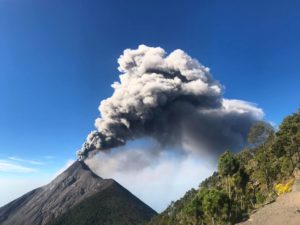
Guatemala , Fuego :
Activity:
Presence of white degassing fumaroles at an approximate height of 4300 meters. They generate 10 to 15 moderate explosions per hour that expel columns of gray ash at a height of 4500 to 4700 m / l (14764 to 15420 feet) dispersing between 10 and 15 km to the west. At night and early in the morning, incandescent impulses were observed at about 200 to 300 meters above the crater with moderate to strong avalanches around the crater towards the Seca, Taniluyá, Ceniza, Trinidad and Las Lajas ravines. .
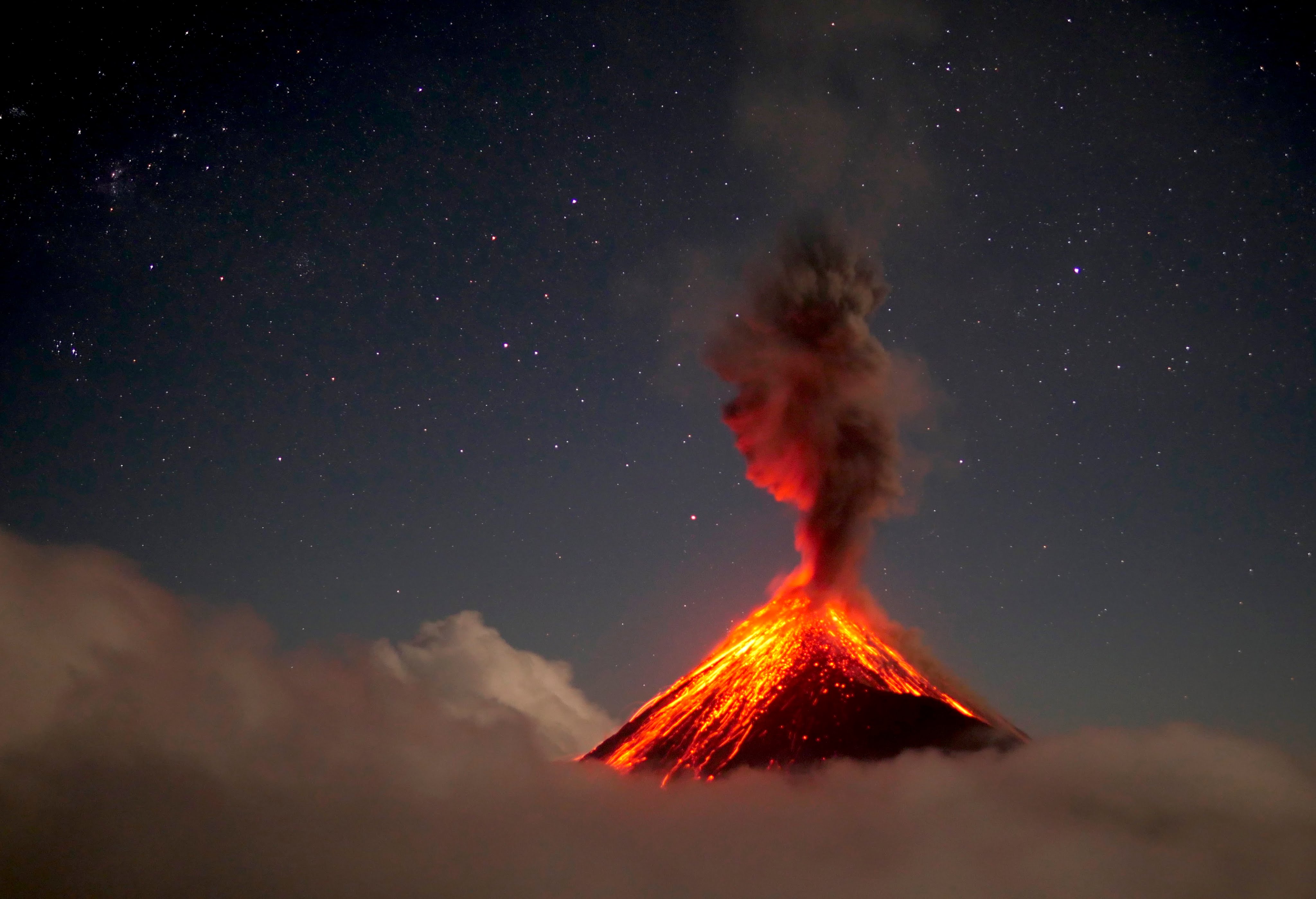
Some of these materials go down to the edge of the vegetation. Avalanches in the Seca Canyon reach a length of 300 meters. Low to moderate rumblings generate shock waves that vibrate the homes of communities near the volcano. Fine particles of ash fall in the areas of Panimaché I, Morelia, Santa Sofia, Porvenir, Palo Verde, Yepocapa and others located in this direction.
Source : Insivumeh .
Photo : 660citynews.com