March 03 , 2019.
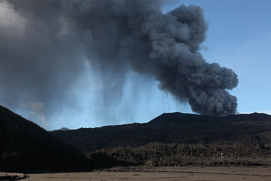
La Réunion , Piton de la Fournaise :
Activity Bulletin from Saturday, March 2, 2019 to 12:00 (local time).
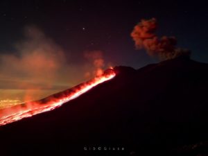
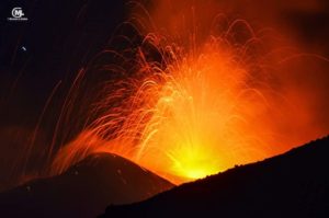
The eruptive activity that resumed on February 19, 2019 at Piton de la Fournaise around 7:10 pm local time continues. Despite slight fluctuations in intensity and relative stability since February 25, an upward trend seems to have emerged in recent days (Figure 1)
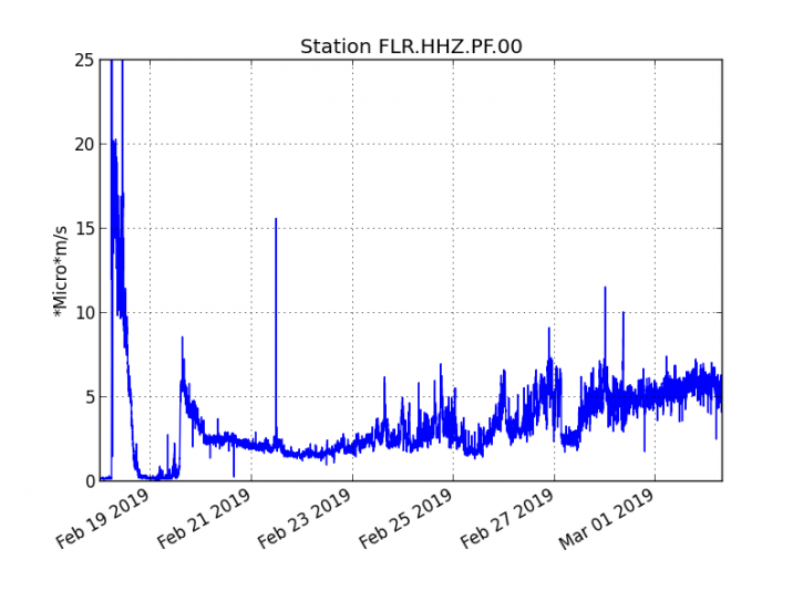
Figure 1: Evolution of the RSAM (indicator of the volcanic tremor and the intensity of the eruption) between 09h48 (05h48 UTC) on February 18th and 11h30 (7h30 UTC) on March 2nd on the seismic station of FLR. (© OVPF / IPGP)
– Over the last 36 hours, 3 superficial volcano-tectonic earthquakes (above sea level) have been recorded.
– After a deflation of the building related to the transfer of magma that occurred on 18/02/2019, the deformations of the summit zone do not show any particular signals.
– The CO2 concentrations in the near-field soil (Cottage volcano area) remain high.
-Over the last 36 hours, surface flows estimated from satellite data, via the HOTVOLC platform (OPGC – University of Auvergne), fluctuated between <1 and 10 m3 / s. Note that low values (or zero values) are recorded when cloud cover does not allow acquisition.
– The total SO2 emissions to the atmosphere recorded by the OVPF NOVAC network (Figure 2) since the beginning of the eruption are estimated at 2.5 kton, a value in the norm of the average eruptions of Piton de la Fournaise.
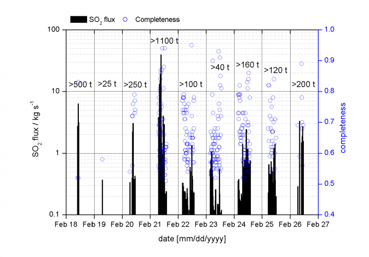
Figure 2: Assessment of SO2 emissions deduced from NOVAC stations after treatment by Santiago Arellano and Bo Galle, NOVAC project managers, between 18 and 27/02/2019.
– A cartography of the lava flow dated 01/03/2018 carried out by the platform OI2 (OPGC – Clermont Auvergne University) from satellite data shows that a third flow arm was set up in the north between the 28/02/2018 and the 01/03/2018 (Figure 3). During this time the other two arms already in place do not seem to have progressed.
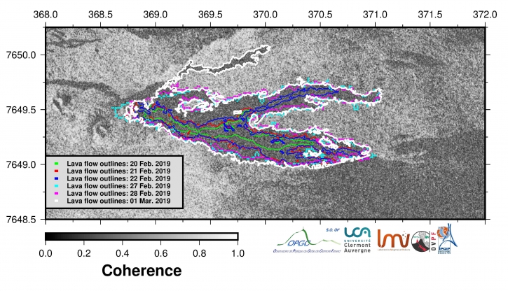
Figure 3: Contours of the lava flows associated with the eruptive episode of 19/02/2019 determined from satellite data by the OI2 platform (Université Clermont Auvergne), dated 20 (green), 21 (red), 22 (blue), 27 (turquoise), 28/02/2019 (pink), 01/03/2019 (white).
A new satellite acquisition from March 1st shows that this new arm split in two during the day of March 1st (Figure 4).
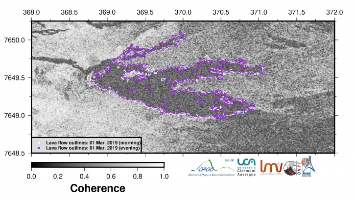
Figure 4: Contours of the lava flows associated with the eruptive episode of 19/02/2019 determined from satellite data by the platform OI2 (University Clermont Auvergne), dated March 1st. Evolution during the day of March 1st (morning in white and evening in purple).
Alert level: Alert 2-2
Source : OVPF
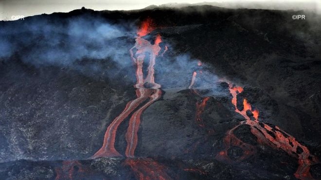
Photo : Richar Bouhet / Imaz Press
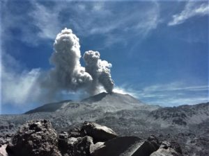
Indonesia , Dukono :
VOLCANO OBSERVATORY NOTICE FOR AVIATION – VONA.
Issued: March 01 , 2019
Volcano: Dukono (268010)
Current Aviation Colour Code: ORANGE
Previous Aviation Colour Code: orange
Source: Dukono Volcano Observatory
Notice Number: 2019DUK12
Volcano Location: N 01 deg 41 min 35 sec E 127 deg 53 min 38 sec
Area: North Maluku, Indonesia
Summit Elevation: 3933 FT (1229 M)
Volcanic Activity Summary:
Eruption with volcanic ash cloud at 22h55 UTC (07h55 local).
Volcanic Cloud Height:
Best estimate of ash-cloud top is around 6173 FT (1929 M) above sea level, may be higher than what can be observed clearly. Source of height data: ground observer.
Other Volcanic Cloud Information:
Ash cloud moving to South – southeast.
Remarks:
Eruption and ash emission is continuing.
Activity Level at Level II (WASPADA). the Dukono (1229 m altitude) undergoes continuous eruptions.
Since yesterday and until this morning, the volcano was clearly visible then covered with fog. It was observed that the smoke from the main crater was white / gray with a high intensity rising between 300 and 700 meters on the summit. The wind is blowing weakly to moderately in the Southeast and South.
The seismographs dated March 2, 2019 recorded:
5 distant tectonic earthquakes
Tremor continuous amplitude 0.5 to 2 mm, dominant value 0.5 mm
Recommendation: People around G. Dukono and visitors / tourists should not have activity, climb or approach the Malupang Warirang crater within 2 km.
Source : Magma Indonesia , PVMBG.
Photo : Photovolcanica.
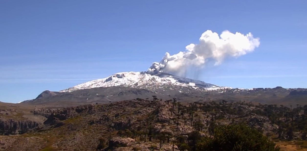
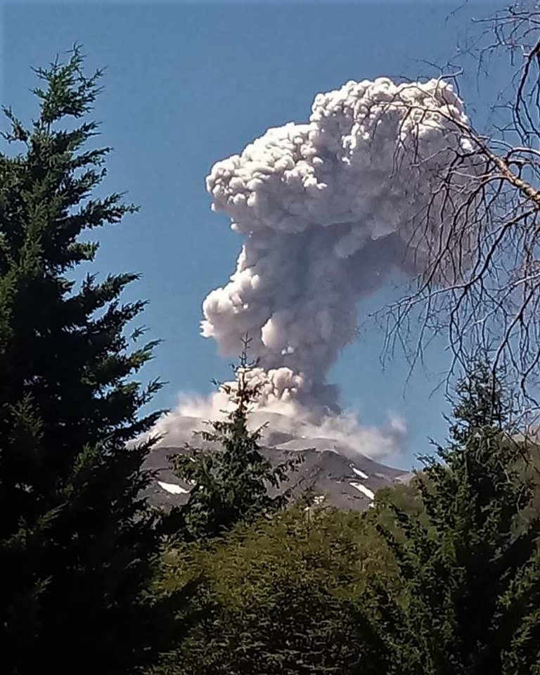
Chile , Copahue / Nevados de Chillan :
Copahue Volcano :
Special Report on Volcanic Activity (REAV), Bio-Bio Region, Copahue Volcano, 02 March 2019, 19:00 Local Time (Continental Chile).
The National Geological and Mining Service of Chile (Sernageomin) publishes the following PRELIMINARY information, obtained through monitoring equipment of the National Volcanic Monitoring Network (NVRN), processed and analyzed at the Volcanological Observatory of the Southern Andes (OVDAS) :
Today, Saturday 02 March 2019 at 18:17 local time (21:17 UTC), the monitoring stations installed near the Copahue volcano recorded an explosive event, associated with the occurrence of an earthquake associated with a fracturing process of rocks . This event was located 11.8 Km north-east of the crater El Agrio.
The characteristics of the most important event, after its analysis, are as follows:
TIME OF ORIGIN: 18h17 (GMT -3)
LATITUDE: -37.779 ° S
LONGITUDE: -71.066 ° W
DEPTH: 7.5 KM
LOCAL MAGNITUDE: 3.5 (ML)
OBSERVATIONS:
At the time of issuing this report, no increase in seismic activity is observed. During the times when it was possible to observe the crater of the volcano, no change in surface activity was noted.
Volcanic Technical Alert Level Remains at Level: Green
Sernageomin continues online monitoring and will inform in a timely manner about any changes observed.
Nevados de Chillan Volcano :
Nuble Region, Nevados Volcano of Chillan, 01 March 2019, 23:23 local time (mainland Chile)
The National Geological and Mining Service of Chile (Sernageomin) publishes the following PRELIMINARY information, obtained from monitoring equipment of the National Volcanic Monitoring Network (RNVV), processed and analyzed at the Volcanological Observatory of the Southern Andes (OVDAS) :
Today, Friday 01 March 2019 at 23:23 local time (02:23 UTC 2 March), monitoring stations near the Nevados volcano of Chillan recorded an explosive event, associated with the occurrence of a long earthquake period (LP), which was associated with fluid dynamics within the volcanic system.
The location of the earthquake after its analysis is:
TIME OF ORIGIN: 23h23 Local time (02h23 UTC)
LATITUDE: 36.8496 ° S
LONGITUDE: 71.3891 ° W
DEPTH: 2.44 KM
REDUCED MOVEMENT: 665.36 cm2
ACOUSTIC SIGNAL: 2.89 Pa reduced to 1 KM
OBSERVATIONS:
The explosion was associated with the recording of a seismic signal having a reduced displacement value (seismic energy) of 665.36 cm2 considered high. Also, it was possible to observe an incandescence associated with emissions of gas and particulate materials at high temperatures, falling on the surroundings of the active crater. The preceding events make it possible to envisage a partial destruction of the dome located in the crater. This event is consistent with the scenario of the current level of activity present. At the time of this report, no other abnormal signals were recorded.
The level of volcanic technical alert remains at the level: ORANGE.
Sernageomin continues online monitoring and will inform in a timely manner about any changes observed.
Source : Sernageomin
Photos : clarin.com , Ovdas.
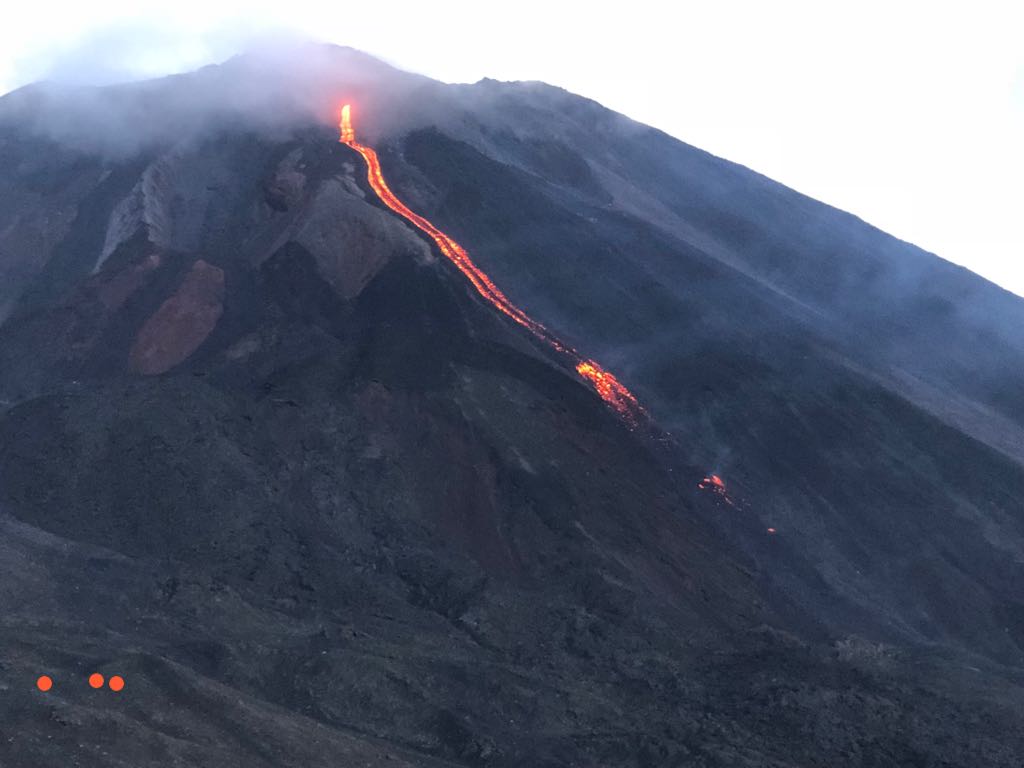
Guatemala , Pacaya .
Type of activity: Strombolian
Morphology: Composite Stratovolcano
Geographical location: 14 ° 22’50˝ Latitude N; 90 ° 36’00˝ Longitude O.
Height: 2,552msnm.
Weather Conditions: Clear
Wind: South West at 3 km / h
Precipitation: 0.0 mm
Activity:
Presence of white degassing fumarole with an approximate height of 900 meters above the crater and a lava flow towards the north with an approximate length of 150 meters. There are avalanches in the direction of the lava flow. The seismic station records the internal tremors due to the rise of the magma and the presence of lava flows.
Source : Insivumeh
Photo : tn8.tv