January 23 , 2019.
Kamchatka , Sheveluch :
VOLCANO OBSERVATORY NOTICE FOR AVIATION (VONA).
Issued: January 23 , 2019.
Volcano:Sheveluch (CAVW #300270)
Current aviation colour code:ORANGE
Previous aviation colour code:orange
Source:KVERT
Notice Number:2019-26
Volcano Location:N 56 deg 38 min E 161 deg 18 min
Area:Kamchatka, Russia
Summit Elevation:10768.24 ft (3283 m), the dome elevation ~8200 ft (2500 m)
On the night of January 17 to 18, a small pyroclastic stream descended on the Sheveluch towards the Baydarnaya River.
Volcanic Activity Summary:
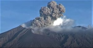
A growth of the lava dome continues (a viscous lava blocks extrude out on the northern part of it), a strong fumarolic activity and an incandescence of the dome blocks and hot avalanches accompanies this process. According to satellite data, a gas-steam plume with some amount of ash on the height 4.0-4.5 km a.s.l. continues to drift to the south-west from the volcano.
Explosive-extrusive eruption of the volcano continues. Ash explosions up to 32,800-49,200 ft (10-15 km) a.s.l. could occur at any time. Ongoing activity could affect international and low-flying aircraft.
Volcanic cloud height:
13120-14760 ft (4000-4500 m) AMSL Time and method of ash plume/cloud height determination: 20190123/0105Z – Video data
Other volcanic cloud information:
Distance of ash plume/cloud of the volcano: 28 mi (45 km)
Direction of drift of ash plume/cloud of the volcano: SSW / azimuth 213 deg
Time and method of ash plume/cloud determination: 20190123/0023Z – MODIS TERRA (31m32)
Source : Kvert.
Photo : Yu. Demyanchuk, Volkstat ru.
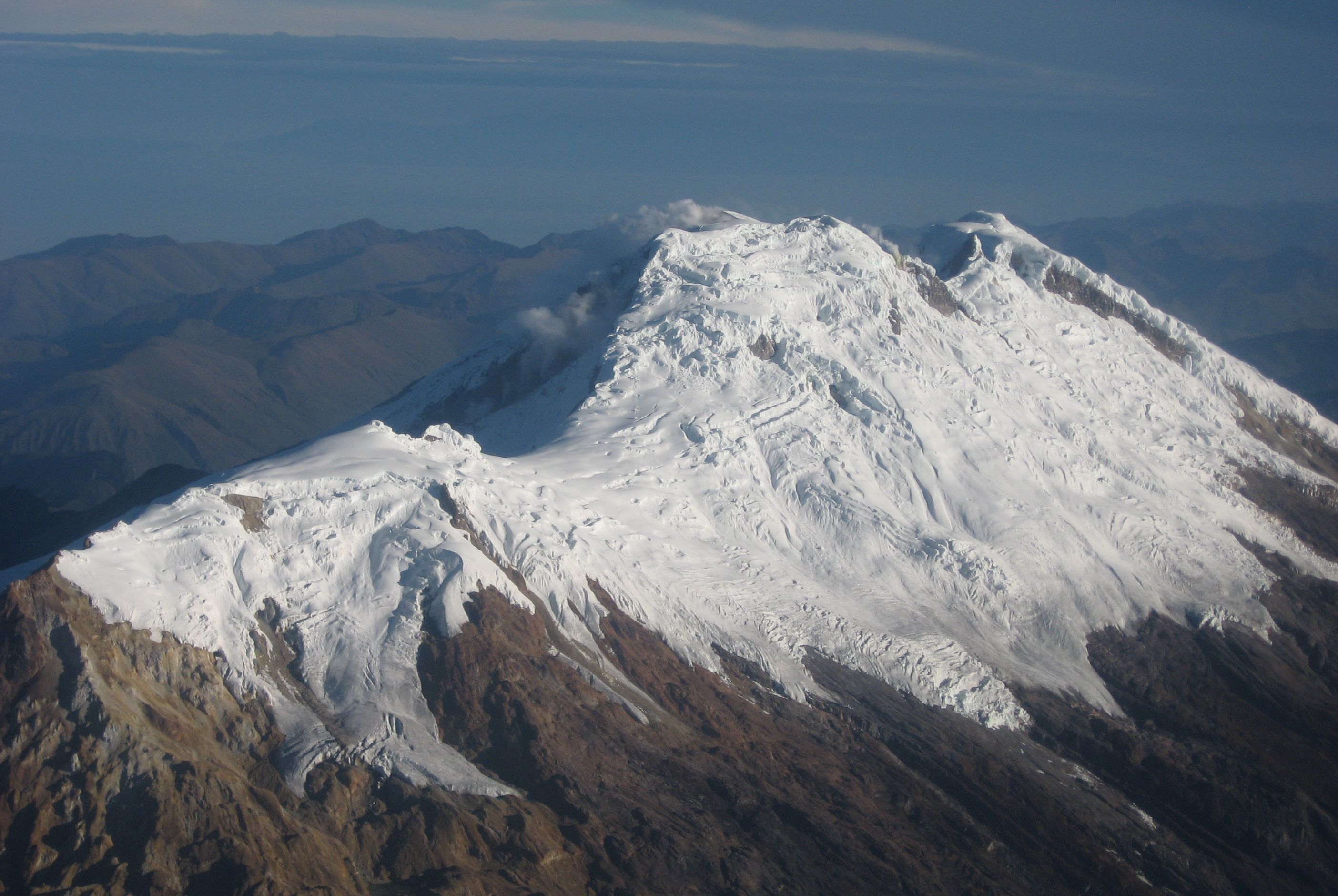
Colombia , Nevado del Huila :
Weekly activity bulletin of the Nevado del Huila volcano
The level of activity of the volcano continues at the level: yellow activity level or (III): changes in the behavior of volcanic activity.
Based on the analysis and evaluation of the information obtained through the monitoring network of the Nevado del Huila volcano, from January 15 to 21, 2019, the COLOMBIAN GEOLOGICAL SERVICE – Volayological and Volatological Observatory of Popayán informs that:
• During the evaluated period, 177 seismic events were recorded, 67 were related to rock fracturing processes (type VT) and 110 to fluid dynamics in volcanic canals. Of these, 107 were classified as long-period type events (LP type) and three (3) low-energy Tremor type pulses (TR type).
• The images obtained during the week by the web cameras of Caloto, Tafxnú, Maravillas and La Palma showed a weak degassing of the volcanic system.
• Sensors for monitoring soil deformation, magnetic fields, and infrasound did not record any variations associated with changes in volcanic activity.
Therefore, it is concluded that during the evaluated period, the volcano exhibited stable behavior. The Colombian geological service is attentive to the evolution of the volcanic phenomenon and will inform in a timely manner any changes that may occur.
Source : SGC.
Photo : SGC
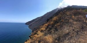
Guadeloupe , La Soufrière :
Tuesday January 22, 2019 at 3:00 pm date: 2019-01-18 / 2019-01-22
Sequence of earthquakes in La Soufrière area of Guadeloupe – Basse Terre
The sequence of volcanic earthquakes that began on Friday, January 18, 2019 at 00:19 local time (January 18, 2019 04h19 GMT *) in the La Soufrière volcano area, continues with the recording of 500 earthquakes since its biginning .
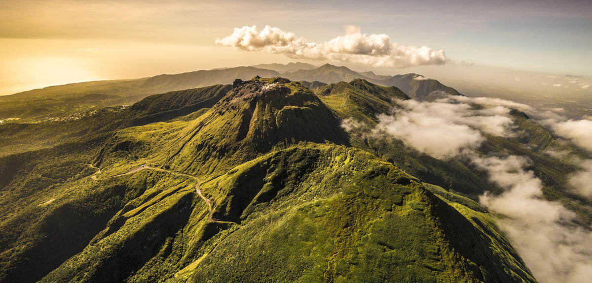
Earthquakes are of very small magnitude (M <1). No earthquakes were reported. The events are located at a depth of <2.5 km under the summit of the dome of La Soufrière.
The alert level remains: yellow, vigilance.
Source : Direction de l’OVSG-IPGP .
Photo : A.-Brusini-hemis-fr.
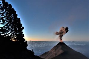
Guatemala , Fuego :
VOLCANOLOGICAL SPECIAL BULLETIN BEFGO n ° 01-2019 Guatemala January 21 , 2019 at 20:15 (local time)
INCREASE IN THE ACTIVITY OF FUEGO VOLCANO.
Type of activity: Vulcanian
Morphology: Composite Stratovolcan.
Geographical location: 14 ° 28’54˝Latitude N; 90 ° 52’54˝Longitude W.
Height: 3,763msnm.
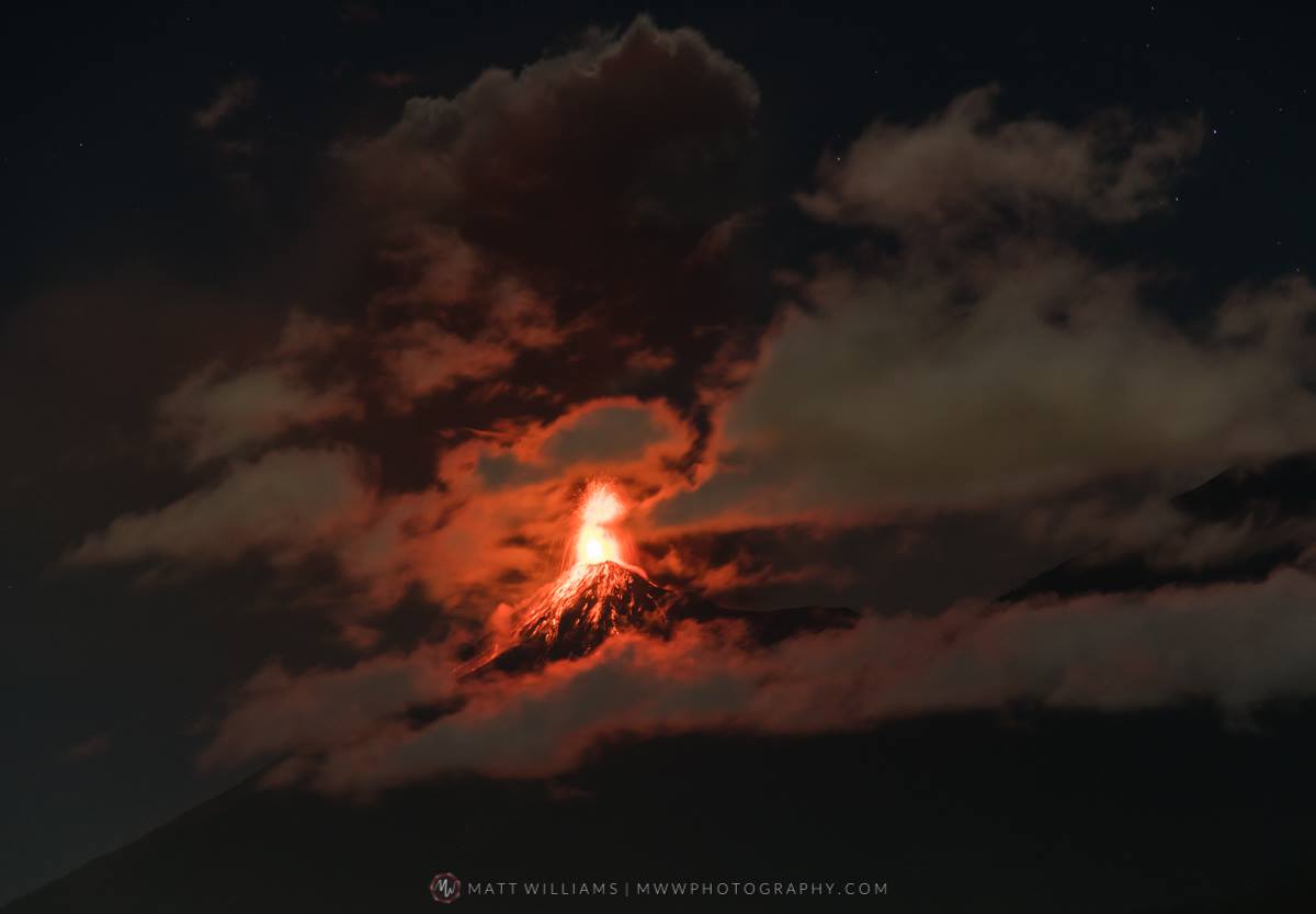
In recent days, the activity of the Fuego volcano is increasing, this is the product of the process of filling the crater, generating moderate and strong explosions, ejecting volcanic material around the crater, with avalanches towards the ravines Las Lajas, Seca, Honda, Cenizas. The ash columns are 4800 to 5000 meters high, (15 748 to 16 404 ft) moving westward, south-west of the volcanic complex, over a distance of 12 kilometers. These explosions generate resonant shock waves, moderate to loud, audible at more than 15 km, roofs and windows of vibrant house more than 12 km, mainly in the villages of Panimache, Morelia, Santa Sofia, Yucales, Palo Verde and others on the southern flank as La Rochela, Ceylon. It was also reported that loud rumblings were audible in San Pedro Yepocapa, Alotenango, Ciudad Vieja, Escuintla and Santa Lucia Cotz.
This activity will be maintained over the days and it is possible that it increases or forms lava flows, it is necessary to be aware of the evolution of the activity.
Source : Insivumeh.
Photo : Matt Williams.
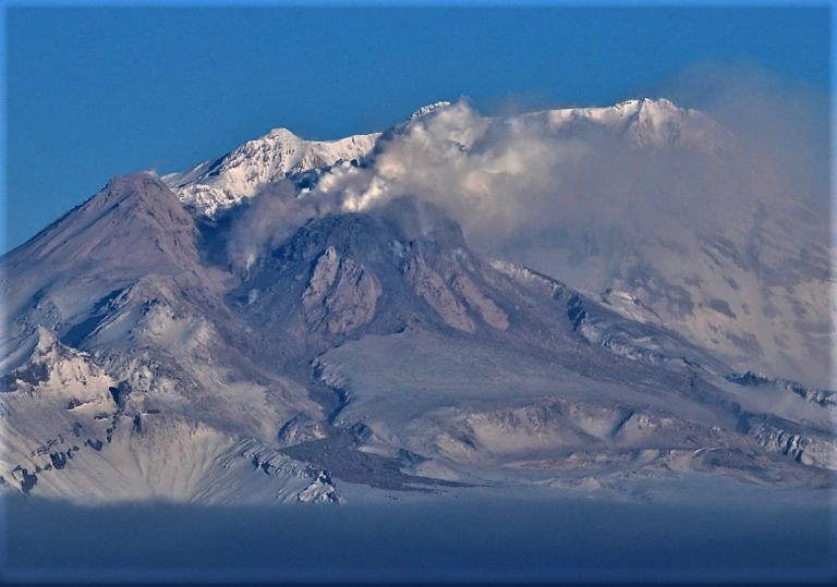
Mexico , Colima :
In Colima, researchers at the University Center for Studies and Research in Vulcanology have detected an increase in steam and gas emissions in the eastern part of the Fuego de Colima crater.
The output of this vapor plume is constant from inside the crater and can be seen several kilometers away.
We spent more than a week with this increase, which was not reflected in the seismicity, the seismicity continues at very low levels and we only found this increase. It is usually associated with the movements of fluids. In this case, the gas could be involved in the volcanic building but they are very small, « said Raúl Arámbula Mendoza, director of the University Center for Studies and Research in Volcanology.
In addition to these fumes, the volcanic monitoring network has recorded tremors, that is, vibrations in the volcanic building.

In February 2017, the Fuego de Colima Volcano entered a phase of passive degassing.
Low volcanic activity allows researchers to renew and expand the surveillance network. For the first time, the Colima civil protection unit broadcasts, via digital media, the warning light of the volcano.
The current activity of the Fuego Volcano in Colima indicates that its behavior could change at any time, so that the authorities maintain an exclusion zone of 5 km from the crater.
The Colima volcanic complex is the most prominent volcanic center of the western Mexican Volcanic Belt. It consists of two southward-younging volcanoes, Nevado de Colima (the 4320 m high point of the complex) on the north and the 3850-m-high historically active Volcán de Colima at the south. A group of cinder cones of late-Pleistocene age is located on the floor of the Colima graben west and east of the Colima complex. Volcán de Colima (also known as Volcán Fuego) is a youthful stratovolcano constructed within a 5-km-wide caldera, breached to the south, that has been the source of large debris avalanches. Major slope failures have occurred repeatedly from both the Nevado and Colima cones, and have produced a thick apron of debris-avalanche deposits on three sides of the complex. Frequent historical eruptions date back to the 16th century. Occasional major explosive eruptions (most recently in 1913) have destroyed the summit and left a deep, steep-sided crater that was slowly refilled and then overtopped by lava dome growth.
Source : Noticieros.televisa. GVP.
Photo : Ineter