March 26 , 2018.
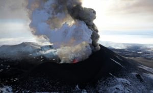
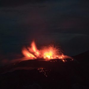
Copahue , Chile :
The Onemi has declared the yellow alert for the community of Alto Biobío because of an increase in the activity of the Copahue volcano, detected in the last hours by the National Service of Geology and Mining (Sernagomin).
A special report of volcanic activity (REAV), published by Sernageomin, reported the occurrence of an explosion of hydrothermal features, and the recording of a sustained increase in the level of bottom tremor, with a slight shift to above the base level of the volcano
In this context, Sernageomin has modified its technical alert at yellow level and Onemi has canceled the preventive early warning, in force since 6 September 2017, and declared a yellow alert for the community of Alto Biobío due to volcanic activity, valid from yesterday and until conditions warrant it.
The Sernageomin recalled that since December 2012, the Copahue volcano has had successive changes in its alert level and its activity has been characterized by weak explosions with fine ash emissions into the atmosphere, through eruptive columns only not more than three kilometers above the volcano.
In this sense, Sernageomin’s National Director, Mario Pereira, said that the National Volcanic Vigilance Network has determined a preventive alert and called on the community to be informed through the official channels.
« We monitor the Copahue volcano 24 hours a day, our specialists have the technology to monitor volcanic activity, and the important thing is that the different institutions of the civil protection system have technical information on what is going on, including the map of potential hazards, « he said.
The Copahue volcano is located on the border with Argentina, in the region of Biobío, 110 kilometers southeast of the city of Los Angeles. Its nearest neighbor is the Callaqui volcano, located 25 kilometers to the west.
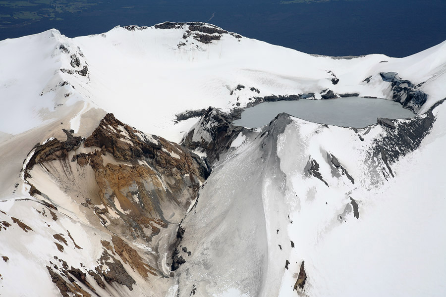
It corresponds to a mainly andesitic stratovolcano that has a dozen craters, concentrating recent activity in the crater called El Agrio, which has a permanent fumarolic activity and an acidic lake inside.
In its geological record, there are also signs of fissural activity and rhyolitic lava domes. It has a permanent ice cover and, for this reason, it is a potential generator of lahars that can reach long distances through the valleys of Chile and Argentina.
With the declaration of the yellow alert, the necessary resources will be put in place to intervene according to the evolution of the event, in order to avoid its growth and its gravity, while minimizing the negative effects on people, their property and the environment.
The yellow alert is declared for the municipality of Alto Biobío because of the activity of the Copahue volcano
24/03/2018 | 21:51 | Biobío
According to the information provided by the OVDAS – SERNAGEOMIN, by special report of volcanic activity (REAV), emitted during these last hours, one notes the appearance of an explosion with hydrothermal characteristics, and of a constant increase the level of tremor reported in the background, with a multi-peak spectral content between 1 and 3.5 Hz, reaching a reduced maximum displacement of 11 cm2, which is an increase compared to the base level of the volcano.
As a result of this context, the OVDAS-SERNAGEOMIN modifies its level of technical alert at the yellow level and in turn the ONEMI cancels the preventive early warning, which remained in force since September 6, 2017 and declared the yellow alert for the municipality of Alto Biobio because of the volcanic activity, this valid from today and until the conditions deserve it.
The SERNAGEOMIN continues with continuous monitoring of the volcano and the ONEMI Biobio Regional Directorate, will maintain coordination with the members of the civil protection system to alert by rapid and adequate response to any emergency situation.
Source : Publimetro, Onemi .
Photo : Silvy Erice, Sernageomin .
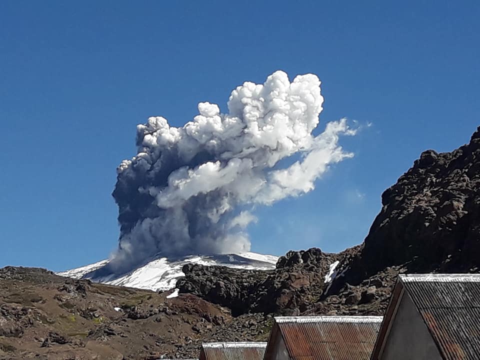
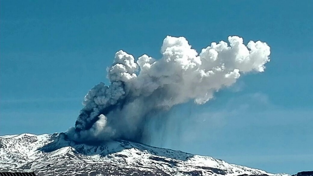
Agung , Indonesia :
VOLCANO OBSERVATORY NOTICE FOR AVIATION – VONA..
Issued: March 26 , 2018.
Volcano: Agung (264020)
Current Aviation Colour Code: ORANGE
Previous Aviation Colour Code: orange
Source: Agung Volcano Observatory
Notice Number:2018AGU18
Volcano Location: S 08 deg 20 min 31 sec E 115 deg 30 min 29 sec
Area: Bali, Indonesia
Summit Elevation: 10054 FT (3142 M)
Volcanic Activity Summary:
Eruption with volcanic ash cloud at 02h09 UTC (10h09 local). Eruption and ash emission is not continuing
Volcanic Cloud Height:
Best estimate of ash-cloud top is around 11654 FT (3642 M) above sea level, may be higher than what can be observed clearly. Source of height data: ground observer.
Other Volcanic Cloud Information:
Ash-cloud is moving Northwest
Remarks:
Seismic activity is dominated by low-frequency and high-frequency volcanic earthquakes
Based on the analysis of visual and seismic data and considering the potential threats of danger, the status of G. Agung was lowered from Level IV (Awas) to Level III (Siaga) on February 10, 2018 at 09:00. Since yesterday and until today, it has been possible to visually observe the volcano until it is covered with fog. . The emission of white fumes, low intensity and low pressure, reaches a height of 150 m above the summit. The wind is heading west.

The recordings of the seismographs dated March 25, 2018 noted:
9 emission earthquakes
2 shallow volcanic earthquake.
5 local tectonic earthquake (TL)
As of March 26, 2018 (00:00 to 18:00) it has been registered:
1 volcanic earthquake.
2 tectonic earthquake.
Recommendations:
The communities around G. Agung and mountaineers / visitors / tourists should not climb, climb or do any activity in the danger zone around the G. Agung crater area and in all areas within 4 km from the crater of G. Agung. The estimated area risks are dynamic and continuously assessed and can be modified at any time based on the most recent observational data from G. Agung.
People who live and move around streams that discharge from Gunung Agung should be aware of the potential danger of a secondary form of lahars, which can occur, especially during the rainy season. The lahar zone follows the streams of the upper reaches of Gunung Agung.
Level 3 (SIAGA) is only valid for a radius of 4 km as mentioned above. Outside the activity area, everything can work like NORMAL and always SAFE.
Source : Magma , VSI.
Ruapehu , New Zealand :
Volcanic Alert BulletinRUA – 2018/02
2018-03-26 14:00:00 +1300 +1300; Ruapehu Volcano
Volcanic Alert Level remains at 1
Aviation Colour Code remains at Green
The episode of volcanic earthquakes beneath Mt Ruapehu has ended, and observations and models indicate the heating phase of the Crater Lake (Te Wai ā-moe) has likewise ended.
Between 15 and 21 March (NZ local time) GNS Science volcanologists detected a sequence of seismic events beneath Mt Ruapehu that can be categorised as volcanic earthquakes (see RUA 2018-01). The sequence now appears to be over. These earthquakes were of relatively small magnitude and consistent with a source beneath the summit area.
The Crater Lake (Te Wai ā-moe) temperature is currently at 38oC. While the temperature has been at an elevated temperature since August 2017 (see also RUA – 2017/01), observations and models suggest that the heat input by the volcano started decreasing this past week. A routine monitoring visit to Te Wai ā-moe this morning to collect water and gas samples observed lake upwelling, gas odors, and a small overflow, consistent with low levels of activity.
Since Te Wai ā-moe reformed in 2003, the lake has undergone many heating and cooling cycles. Current observations are consistent with normal minor unrest behaviour. The Volcanic Alert Level, therefore, remains at 1 and the Aviation Colour Code at Green.
Volcano Alert Level 1 corresponds to minor unrest. Volcanic unrest hazards can occur on and near the volcano, and may include steam eruptions, volcanic gases, earthquakes, landslides, uplift, subsidence, changes to hot springs, and/or lahars (mudflows). Eruptions can occur with little or no warning.
GNS Science continues to closely monitor Mt Ruapehu and our other active volcanoes through the GeoNet project.
Source : Geonet.
Popocatepetl , Mexico :
March 25, 11:00 am (March 25, 17:00 GMT)
During the last 24 hours, through the monitoring systems of the Popocatepetl volcano, 20 low intensity exhalations accompanied by steam, gas and sometimes by small quantities of ash have been identified. Five volcano-tectonic earthquakes at 15:21 h, 16:50 h, 18:06 h yesterday and 00:54 h, 06:51 h today with magnitudes of 3.0, 1.8, 1, 9, 1.6 and 2.7 were also recorded respectively.
During the night, a slight incandescence was observed in the crater area.
At the time of this report, there is a slight emission of water vapor and gas with a predominant direction towards West-South-West.
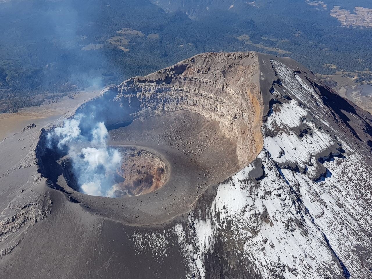
On March 16, 2018, a reconnaissance flight of the Popocatépetl volcano was carried out with the support of the federal police. During this one, it could be corroborated that the internal crater keeps its dimensions of 320 m in diameter and about 100 m of depth. In its bottom, it was possible to observe a small dome (No. 78) 50 m in diameter and about 30 m thick. On the walls of the internal crater, remains of earlier domes could be seen. During the overflight, gas emissions could be observed on the surface of this new dome. It is likely that in the next few days to a few weeks this dome will increase in size and will eventually be destroyed by explosions.
CENAPRED asked not to approach the volcano and in particular the crater, because of the risk of falling of projectiles, and in case of heavy rain to remain far from the bottom of the ravines because of the danger of landslides and flows of mud.
T
he volcanic warning light of the Popocatepetl volcano is located at Amarillo Phase 2.
Source : Cenapred .