October 29 , 2025.
Italy , Stromboli :
WEEKLY BULLETIN, October 20, 2025 to October 26, 2025. (Publication date: October 28, 2025).
ACTIVITY SUMMARY
Based on monitoring data, the following points are highlighted:
1) VOLCANOLOGICAL OBSERVATIONS: During this period, ordinary Strombolian-type eruptive activity was observed. The total hourly frequency varied from moderate (8 events/hour) to high (17 events/hour). The intensity of the explosions was mainly low in the northern crater area and low to moderate in the central-southern area.
2) SEISMOLOGY: The monitored seismic parameters showed no significant variation.
NOTE: This bulletin is compiled from data acquired from a maximum of 8 stations.
3) GROUND DEFORMATION: Ground deformation monitoring networks have not shown significant variations.
4) GEOCHEMISTRY: SO2 flux at an average level.
Soil CO2 flux in the Pizzo area (STR02) at average values.
C/S ratio in the pen: no update.
The dissolved helium isotope ratio (R/Ra) in the thermal aquifer is high.
Soil CO2 flux in the San Bartolo area: average values.
Soil CO2 flux in the Scari area: high values.
5) SATELLITE OBSERVATIONS: Satellite-observed thermal activity in the summit area was generally low.
VOLCANOLOGICAL OBSERVATIONS
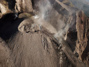
During the observation period, Stromboli’s eruptive activity was characterized by the analysis of images recorded by the INGV-OE monitoring cameras located at an altitude of 190 m (SCT-SCV) and at Punta dei Corvi (SPCT). Explosive activity was primarily produced by five eruptive vents located in the North Crater area (N) and at least two vents in the Central-Southern Crater area (CS).
Due to unfavorable weather conditions on October 22 and 23, visibility from the crater terrace was insufficient for a proper description of the eruptive activity.
Observations of explosive activity captured by surveillance cameras:
Five active winds were observed in the North Crater area, two in sector N1 and three in sector N2, producing low-intensity explosive activity (less than 80 m high) and sometimes medium-intensity activity (less than 150 m high). The eruptive products consisted mainly of coarse material (bombs and lapilli).
The average frequency of explosions varied, ranging from 7 to 14 explosions per hour.
Two main vents were observed in the Central-South Crater area, exhibiting, respectively, explosions of fine material mixed with coarse material and explosions of coarse material of low to medium intensity. The average frequency of explosions varied, ranging from 1 to 5 events per hour.
Source : INGV.
Photo : Stromboli stati d’animo / Sebastiano Cannavo , Capture d’écran .
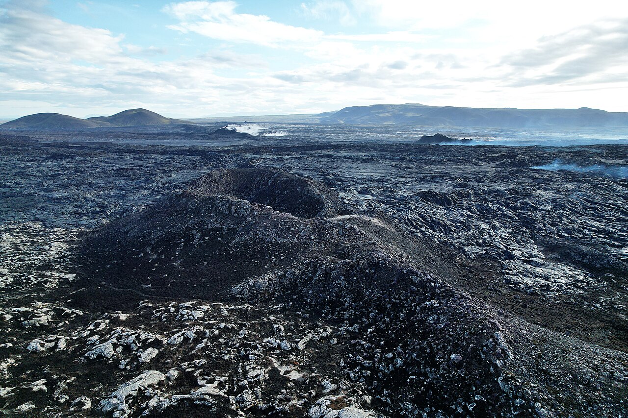
Iceland , Reykjanes Peninsula :
Around 14 million cubic meters of magma has accumulated beneath Svartsengi since the last eruption . Updated 28 October 2025
Hazard assessment unchanged
Key points
Uplift and magma accumulation beneath Svartsengi continues.
The volume of magma that has left Svartsengi during each magma intrusion event has ranged between 12 and 31 million cubic meters.
There is still considerable uncertainty regarding the timing of the next event.
The hazard assessment remains unchanged and is valid until November 11.
Ground subsidence continues near Krýsuvík, though it has slowed in recent weeks.
Deformation
About 14 million cubic meters of magma have accumulated beneath Svartsengi since the last eruption. Based on previous events in the Sundhnúkur crater row, the likelihood of a new magma intrusion and eruption increases once a similar volume of magma has recharged beneath Svartsengi as was released during the last event. Looking at eruptions in the Sundhnúkur crater row since March 2024, the amount of magma that was released from Svartsengi each time has varied considerably — from 12 million to 31 million cubic meters. Therefore, there is still considerable uncertainty about the exact timing of the next event.
Earthquake activity
Seismic activity near Grindavík and the Sundhnúkur crater row remains rather low, with only occasional small earthquakes of around or just above magnitude 1.0 being recorded. Most of these are located between Hagafell and Grindavík. A short swarm of small earthquakes occurred along the Sundhnúkur crater row on October 11th, when just over 20 earthquakes were detected, however since then, the number has mostly been five earthquakes per day.
Activity near Krýsuvík
Earthquake activity near Krýsuvík continues, with numerous small earthquakes recorded daily. On October 22, two earthquakes larger than magnitude 3 occurred west of Kleifarvatn, measuring M3.1 and M3.6. On that day, over 120 earthquakes were recorded in the area. Subsidence, observed since the summer, also continues in the region — amounting to about 55 mm at the Móhálsadalur GPS station west of Kleifarvatn since early June. However, the rate of subsidence has decreased in recent weeks.
Source : IMO.
Photo : Sundhnukur / Steinninn / Wiki.
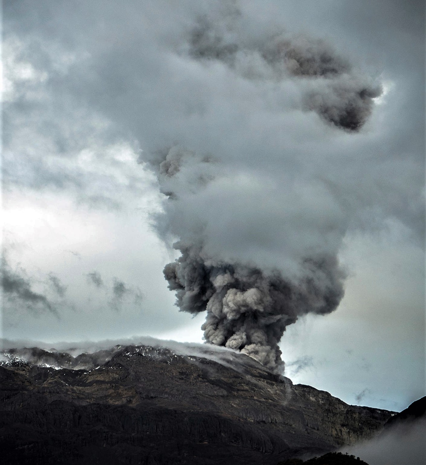
Colombia , Nevado del Ruiz :
Manizales, October 28, 2025, 12:00 PM
Regarding the monitoring of activity at the Nevado del Ruiz volcano, the Colombian Geological Survey (SGC), an agency under the Ministry of Mines and Energy, reports the following:
During the week of October 21-27, 2025, the volcano continued to exhibit unstable behavior. The main variations in monitored parameters, compared to the previous week, were as follows:
– Seismic activity associated with rock fracturing processes within the volcanic edifice increased significantly, both in the number of recorded earthquakes and in the seismic energy released. This increase in seismicity occurred primarily on October 27, and more specifically between 1:48 PM and 10:00 PM. The earthquakes mainly occurred on the northwest and north flanks of the volcano, at distances of 3 to 4 km from the Arenas crater and at depths ranging from 5 to 7 km below the summit. The maximum recorded magnitude was 3.0, corresponding to the earthquake recorded at 1:48 PM, located 4 km north of the crater at a depth of 6 km, and felt by staff at Los Nevados National Natural Park in the Brisas sector. It is worth noting that on that day (October 27), the number of seismic events reached its highest point for both the week and the year, with the highest magnitude recorded that week and the second highest of the year.
Seismic activity, although less intense, was also recorded in the Arenas crater and, more sporadically, on the other flanks of the volcano. On October 24, seismicity was observed related to the activity of the lava dome (protuberance or mound) located at the bottom of the crater, characterized by low levels of seismic energy.
Short-duration seismicity associated with fluid dynamics in volcanic conduits decreased in the number of recorded earthquakes, while maintaining similar levels of seismic energy released. The energy levels of these events were low to occasionally moderate. In contrast, long-duration signals increased in the number of events, although their energy levels remained low. Thanks to the cameras (conventional and thermal) used to monitor the volcano, several pulsating ash emissions and some variations in the apparent temperature of the emitted material, associated with this type of seismic signal, were confirmed.
The volcano continued to emit water vapor and volcanic gases into the atmosphere, primarily sulfur dioxide (SO₂). The estimated SO₂ flux, associated with degassing processes, was variable and slightly lower than the values recorded the previous week.
This was mainly due to weak winds and changes in wind direction, which were unfavorable to the monitoring stations. Furthermore, SO₂ emissions continued to be detected by satellite monitoring.
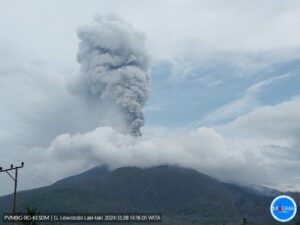
– The vertical height of the column of gas, water vapor, or ash reached 1,200 m, measured above the summit of the volcano. During the dispersal, the maximum height reached 1,400 m during the ash emission recorded on October 22 at 9:17 PM. Regarding the direction of dispersal, the column drifted primarily towards the northwest and north-northwest flanks of the volcanic structure and, to a lesser extent, towards its west and north-northeast flanks. Ashfall was reported in Manizales (Caldas) on the afternoon of October 23, likely due to the remobilization of material caused by strong winds.
Monitoring of thermal anomalies at the bottom of the Arenas crater, using satellite monitoring platforms, remained limited by the thick cloud cover in the volcanic area. However, some low-energy anomalies were reported.
Source : SGC.
Photo : Álex Palacio.
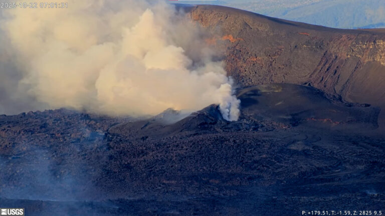
Hawaii , Kilauea :
HAWAIIAN VOLCANO OBSERVATORY DAILY UPDATE , U.S. Geological Survey
Tuesday, October 28, 2025, 8:20 AM HST (Tuesday, October 28, 2025, 18:20 UTC)
19°25’16 » N 155°17’13 » W,
Summit Elevation 4091 ft (1247 m)
Current Volcano Alert Level: WATCH
Current Aviation Color Code: ORANGE
During the lapse in appropriations, the USGS Hawaiian Volcano Observatory (HVO) continues to maintain monitoring networks and issue updates and notifications of volcanic activity via the Hazard Notification Service. Volcano monitoring data will continue to be available on the HVO website. Static website content will not be updated until further notice and information may become outdated over time.
Activity Summary:
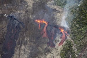
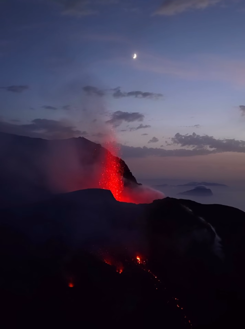
Episode 35 of the ongoing Halemaʻumaʻu eruption ended on October 18 after 7.5 hours of continuous lava fountaining. Both vents continue to exhibit incandescence. Kīlauea summit inflation continues along with seismic tremor and vent glow indicating that another lava fountaining episode is probable. Models suggest a likely forecast window of November 5–11 for episode 36 with November 6-9 most probable.
Summit Observations:
The north and south vents continued to roughly alternate periods of moderate to bright glow overnight with flames frequently observed from the north vent during bright glow. Summit behavior has remained relatively constant over the past several days.
The summit continues to inflate. The Uēkahuna tiltmeter (UWD) has recorded about 1 microradian of inflationary tilt over the past 24 hours and over 17.5 microradians of inflationary tilt since the end of episode 35. Tremor patterns continue with defined peaks spaced 5-10 minutes apart that correlate well with the alternating periods of glow from both vents. This pattern indicates that strong gas pistoning is occurring within the vents and the alternating patterns indicate the vents are probably coupled.
Plumes of gas continue from both vents this morning and sulfur dioxide (SO2) gas emissions remain at background levels, typically between 1,200 and 1,500 tonnes per day.
Source et photo : HVO.
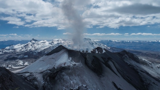
Peru , Sabancaya :
Local date and time: October 27, 2025 – 2:12 PM
Bulletin analysis period: October 20-26, 2025
Volcanic alert level:
Orange alert level: The volcano’s eruptive activity has increased significantly. Increased seismic activity, frequent explosions, and emissions of ash and ballistic fragments have been observed.
Conclusions:
The IGP reports that the Sabancaya volcano continues its eruptive process. During this period, no volcanic explosions were recorded; however, emissions of water vapor and gas were observed, reaching a maximum altitude of 1,300 m above the volcano’s summit, in addition to seismic activity associated with the movement of magmatic fluids and internal fracturing.
Recommendations
Adopt preventive measures in accordance with the current orange volcanic alert level.
Do not approach within 12 km of the crater. In case of ashfall, cover your nose and mouth with damp cloths or a mask. Keep the doors and windows of your home closed.
Stay informed about the volcanic activity of Sabancaya through the reports and bulletins published by the IGP (Geographical Institute of the Pyrenees).
Outlook
The occurrence of future volcanic explosions generating eruptive columns more than 2 km high is considered likely, with a risk of impact on districts located in the Colca Valley and surrounding areas due to the dispersal of volcanic ash.
Source : Cenvul.
Photo : IGP