September 18 , 2025 .
Japan , Meakan-dake :
The Japan Meteorological Agency (JMA) reported increasing unrest at Me-Akan (also known as Meakan-dake, which means Meakan Peak) of the Akan volcanic complex during 11-15 September. The number of small-amplitude volcanic earthquakes with epicenters near Ponmachineshiri Crater began to increase at around 15h00 on 11 September and remained elevated during the week with daily counts of 19-50 events. A large tilt change in the direction of the crater was detected at 14h40 on 12 September, followed by a period of volcanic tremor during approximately 14h40-14h47. Tilt continued at a lower rate through 15 September. At around 18h00 on 12 September, the typical white steam-and-gas plumes at 96-1 Crater within Ponmachineshiri became more voluminous and taller, rising to 100 m above the crater rim and drifting N, NE, and E.
The plumes remained voluminous on 12, 13, and 15 September; weather conditions obscured views on 14 September. Increased thermal activity at the crater was confirmed based on field observations on 15 September. At 15h20 on 15 September the Alert Level was raised to 2 (the second lowest level on a 5-level scale) and the public was warned to exercise caution within 500 m of Ponmachineshiri Crater. During an overflight on 16 September scientists confirmed that the vigorous steam-and-gas plumes were rising 200 m above 96-1 Crater and there were proximal ash deposits, mainly to the N. No significant changes were detected in the ground surface temperatures around 96-1 Crater.
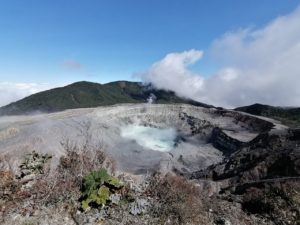
Akan is a 13 x 24 km caldera located immediately SW of Kussharo caldera. The elongated, irregular outline of the caldera rim reflects its incremental formation during major explosive eruptions from the early to mid-Pleistocene. Growth of four post-caldera stratovolcanoes, three at the SW end of the caldera and the other at the NE side, has restricted the size of the caldera lake. Conical Oakandake was frequently active during the Holocene. The 1-km-wide Nakamachineshiri crater of Meakandake was formed during a major pumice-and-scoria eruption about 13,500 years ago.
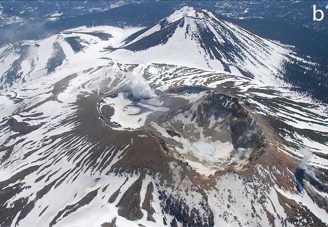
Within the Akan volcanic complex, only the Meakandake group, east of Lake Akan, has been historically active, producing mild phreatic eruptions since the beginning of the 19th century. Meakandake is composed of nine overlapping cones. The main cone of Meakandake proper has a triple crater at its summit. Historical eruptions at Meakandake have consisted of minor phreatic explosions, but four major magmatic eruptions including pyroclastic flows have occurred during the Holocene.
Sources: Japan Meteorological Agency (JMA), GVP .
Photos : STV News ( capture d’écran) , Keiji Wada et JMA. – via GVP/ Bernard Duyck / FB.
Kamchatka , Sheveluch :
VOLCANO OBSERVATORY NOTICE FOR AVIATION (VONA)
Issued: September 17 , 2025.
Volcano: Sheveluch (CAVW #300270)
Current aviation colour code: ORANGE
Previous aviation colour code: orange
Source: KVERT
Notice Number: 2025-84
Volcano Location: N 56 deg 38 min E 161 deg 18 min
Area: Kamchatka, Russia
Summit Elevation: 3283 m (10768.24 ft), the dome elevation ~2500 m (8200 ft)
Volcanic Activity Summary:
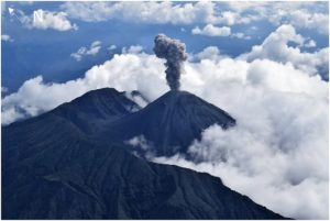
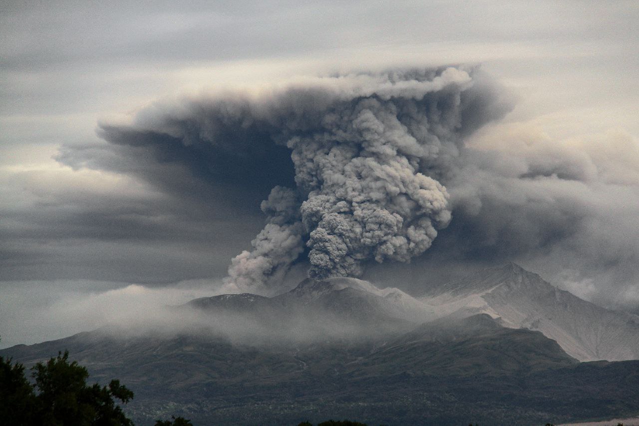
An extrusive-effusive eruption of the Young Sheveluch volcano continue. According to satellite data by KVERT, explosions sent ash up to 3.5-4 km a.s.l., and an ash plume extending about 40 km to the west-southwest of the volcano.
An extrusive-effusive eruption of the volcano continues. The danger of ash explosions up to 10 km (32,800 ft) a.s.l. remains. Ongoing activity could affect international and low-flying aircraft.
Volcanic cloud height:
3500-4000 m (11480-13120 ft) AMSL Time and method of ash plume/cloud height determination: 20250917/2130Z – Himawari-9 14m15
Other volcanic cloud information:
Distance of ash plume/cloud of the volcano: 40 km (25 mi)
Direction of drift of ash plume/cloud of the volcano: W / azimuth 266 deg
Time and method of ash plume/cloud determination: 20250917/2300Z – Himawari-9 14m15
Source : Kvert
Photo : Viktor Frolov (archive 2024)
Hawaii , Kilauea :
HAWAIIAN VOLCANO OBSERVATORY DAILY UPDATE , U.S. Geological Survey
Wednesday, September 17, 2025, 9:32 AM HST (Wednesday, September 17, 2025, 19:32 UTC)
19°25’16 » N 155°17’13 » W,
Summit Elevation 4091 ft (1247 m)
Current Volcano Alert Level: WATCH
Current Aviation Color Code: ORANGE
Activity Summary:
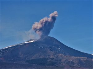
Summit inflation continues and episode 33 lava fountaining is likely in the next 1-4 days. Models suggest episode 33 is likely to begin between September 17 (today) and 20 but could start later if the rate of inflation decreases. Glow was visible from the north and south vents in the livestream overnight, and gas pistoning has caused several small vent overflows this morning 8:38 AM HST marking the start of intermittent precursory eruptive activity.
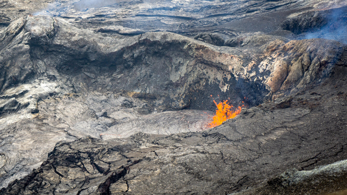
Cyclic rising and falling of the lava pond at the Halema‘uma‘u north vent was indicative of ongoing gas pistoning during the morning of September 17. Seismometers have tracked this gas pistoning since shortly after the end of Kīlauea summit eruptive episode 32 on September 2, but only in the past couple days has lava risen high enough for the cycles to be visible. This activity was observed by Hawaiian Volcano Observatory scientists on the western crater rim, which afforded an excellent view of the north vent
Summit Observations:
The Uēkahuna tiltmeter (UWD) has recorded approximately 21.3 microradians of inflationary tilt since episode 32 ended, and inflation continues this morning. Glow in the north vent has been visible for the past several days, and over the past 24 hours the magma column has been rising and falling in the vent in cycles (gas pistoning), which has been common in the build up to lava fountaining episodes. This morning, several of the gas piston cycles resulted in small amounts of lava briefly overflowing the crater at the north vent. Intermittent glow overnight at the south vent suggests gas pistoning in that vent as well.
Elevated degassing continues from the vent. Average sulfur dioxide (SO2) emission rates during inter-episode pauses are typically 1,200 to 1,500 t/d, though emission rates vary on short timescales in association with gas pistoning.
Rift Zone Observations:
Rates of seismicity and ground deformation remain very low in the East Rift Zone and Southwest Rift Zone, with no significant earthquake activity in the past 24 hours outside of the summit. Sulfur dioxide (SO2) emissions from the East Rift Zone remain below the detection limit.
Source : HVO
Photo : USGS / C. Cauley.
Indonesia , Lokon-Empung :
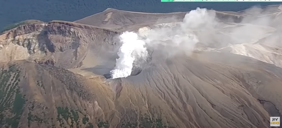
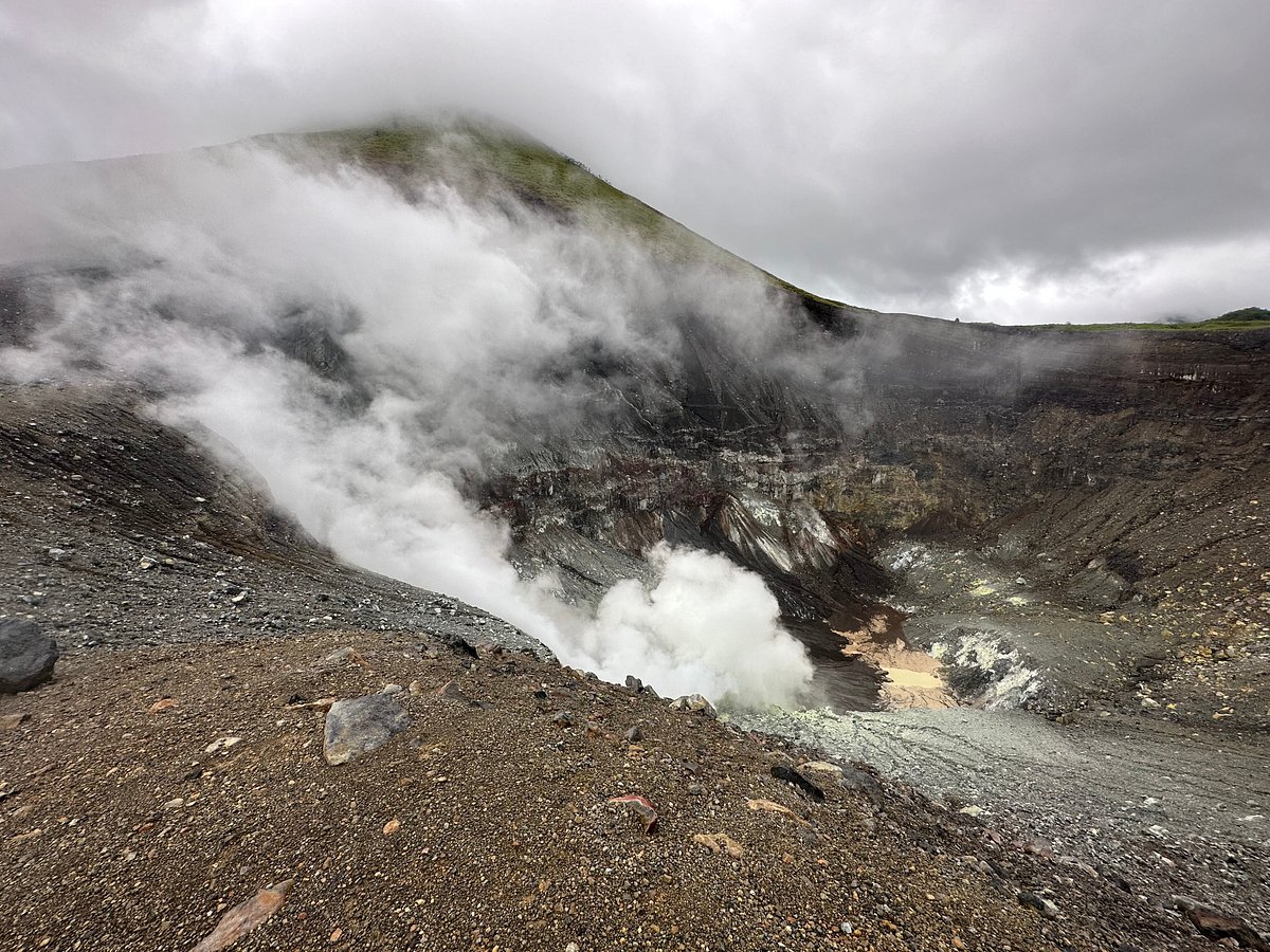
The Pusat Vulkanologi dan Mitigasi Bencana Geologi (PVMBG) reported continuing unrest at Lokon-Empung during 10-16 September. Seismicity continued to be elevated. Daily white steam-and-gas plumes rose as high as 150 m above the Tompaluan Crater rim and drifted in multiple directions. Incandescence at the crater was visible in a few nighttime webcam images. The Alert Level remained at 3 (on a scale of 1-4) and the public was warned to stay 2.5 km away from Tompaluan Crater.
Seismic Observations
A shallow volcanic earthquake with an amplitude of 5 mm and a duration of 4 seconds.
Three distant tectonic earthquakes with an amplitude of 4 to 34 mm, and a duration of 50 to 175 seconds.
Recommendations
(1) The public and tourists should avoid approaching the Tompaluan Crater (the center of activity) within a 2.5 km radius.
(2) In the event of an eruption and ashfall, the public is advised to stay indoors. When outdoors, it is recommended to wear protection for the nose, mouth, and eyes (goggles).
Sources : Pusat Vulkanologi dan Mitigasi Bencana Geologi (PVMBG, également connu sous le nom de CVGHM), GVP.
Photo : Paul S.
Colombia , Chiles / Cerro Negro :
San Juan de Pasto, September 16, 2025, 5:15 p.m.
Following monitoring of the activity of the Chiles-Cerro Negro Volcanic Complex (CVCCN), the Colombian Geological Survey (SGC), an entity affiliated with the Ministry of Mines and Energy,
reports that:
From September 9 to 15, 2025, the main variations in the monitored parameters compared to the previous week were:
• Seismic occurrence decreased slightly; however, the energy released increased significantly. Seismicity associated with rock fracturing continues to predominate, followed by seismicity related to fluid dynamics.
The recording of very low-frequency seismicity is a new development this week.
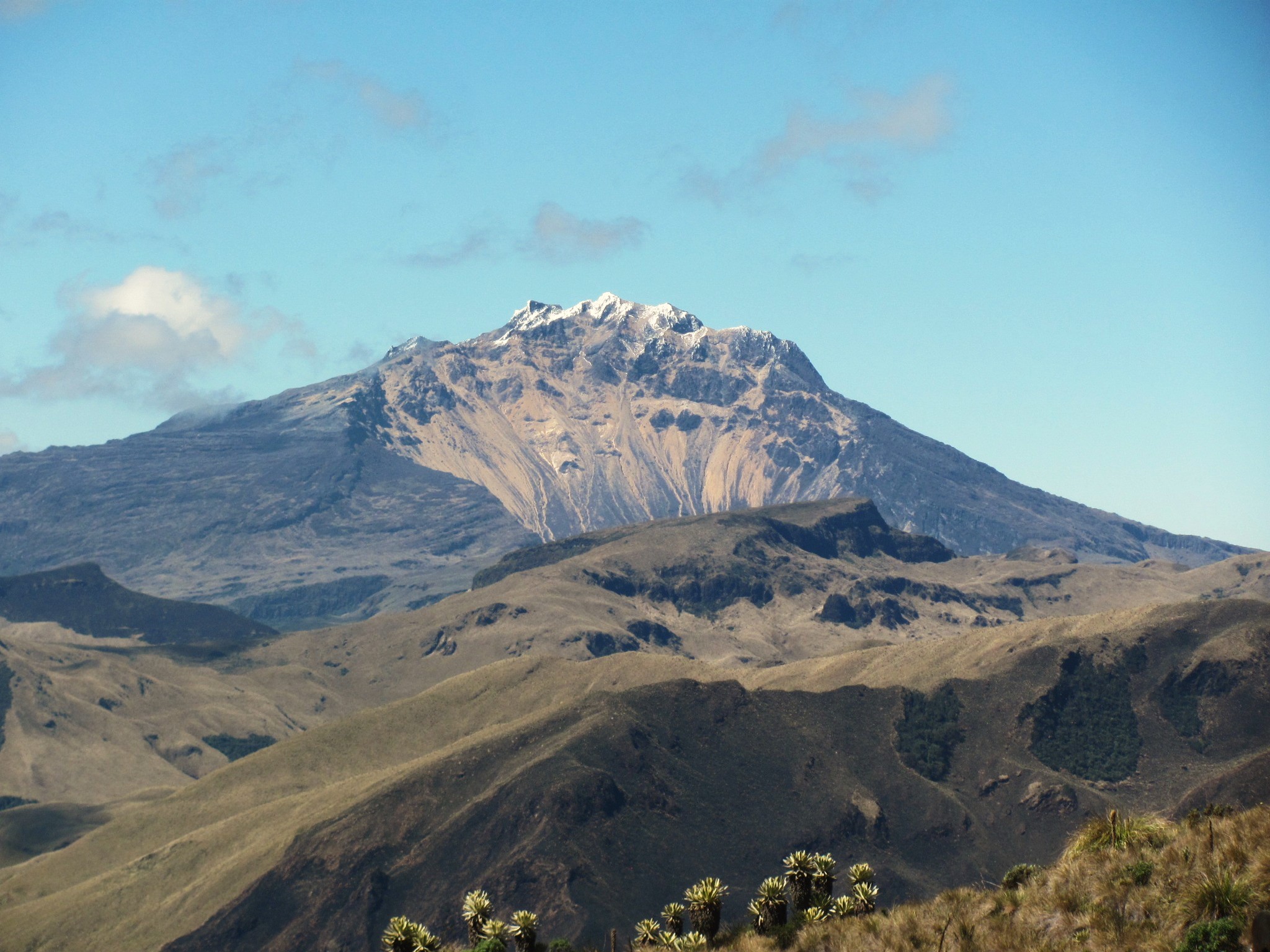
• Localized seismicity was concentrated in two main groups. The first group was located within a 1.5 km radius of the summit of Chiles Volcano (4,700 m above sea level), with a northwest-southeast orientation. The earthquakes occurred at depths ranging from 2.0 to 4.2 km. A magnitude 3.5 earthquake was recorded on September 14 at 10:23 p.m. (local time) and was reportedly felt in the municipality of Cumbal. The event, at a depth of 4.0 km, occurred 0.4 km southeast of the summit. A second group was recorded between the two volcanoes, at depths ranging from 2.9 to 4.3 km. The largest earthquake in this group was magnitude 3.1.
• Analysis of information obtained from satellite sensors and ground stations continues to indicate variations related to deformation processes in the volcanic area.
Based on the assessment and correlation of monitored parameters, the SGC recommends closely monitoring their developments through weekly bulletins and other information published through our official channels, as well as instructions from local and departmental authorities and the National Disaster Risk Management Unit (UNGRD).
Volcanic activity remains on yellow alert: active volcano with changes in the baseline behavior of monitored parameters and other manifestations.
Source et photo : SGC.