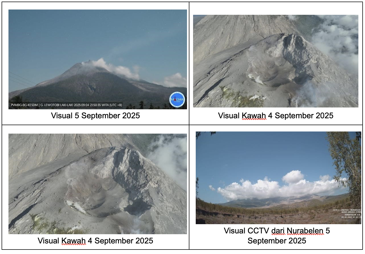
September 6 , 2025.
Indonesia , Lewotobi Laki-laki :
SPECIAL REPORT ON THE CHANGE IN THE ACTIVITY LEVEL OF MOUNT LEWOTOBI LAKI-LA, FROM LEVEL III (SIAGA) TO LEVEL IV (AWAS), ON SEPTEMBER 6, 2025 AT 10:00 WITA.
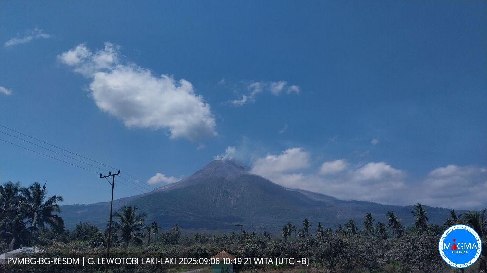
Mount Lewotobi Laki-laki, located in East Flores Regency, East Nusa Tenggara, has once again recorded a significant increase in volcanic activity. The Volcanology and Geological Hazard Mitigation Center (PVMBG) of the National Geological Agency (BNN) has again raised its activity level from Level III (Siaga) to Level IV (Awas).
The current activity status of Mount Lewotobi Laki-laki is as follows:
The volcano is clearly visible in moderately dense fog. White, thin, moderate to thick smoke is observed from the main crater, approximately 50 to 1,000 meters from the summit. Avalanches have occurred, but the distance and direction of the slides have not been visually observed.
Seismic data from August 30 to September 4, 2025, included:
1 avalanche earthquake,
7 emission earthquakes,
3 harmonic tremor earthquakes,
131 nonharmonic tremor earthquakes,
20 low-frequency earthquakes,
53 deep volcanic earthquakes,
7 local tectonic earthquakes,
31 distant tectonic earthquakes.
On September 6, 2025, continuous tremor occurred, indicating the approach of magma to the surface and the risk of an explosive eruption.
Seismic data show a significant increase in harmonic tremor and deep volcanic earthquakes. This indicates a new magma supply from depth and migration of magma from shallow areas to the surface, although the movement is relatively slow.
From August 30 to September 6, Mount Lewotobi Laki-laki did not erupt, indicating an obstruction of the magma conduit. This situation hinders magma supply, increasing seismicity without the release of energy through eruptions. This accumulated pressure could trigger an explosive eruption. Furthermore, on September 5, 2025, a shallow volcanic earthquake was recorded, which is rare at Mount Lewotobi Laki-laki, as it is an open system, allowing internal materials to rise to the surface unhindered.
Deformation monitoring using an inclinometer over the past week indicates a gradual inflation of the volcano’s body. This situation requires increased vigilance as it could trigger an eruption. Meanwhile, GNSS data show a deflationary trend, indicating that volcanic activity is occurring primarily at shallow depths.
Based on the results of a comprehensive analysis and evaluation of visual and instrumental monitoring, the activity level of Mount Lewotobi Laki-laki has been raised from Level III (SIAGA) to Level IV (AWAS) as of September 6, 2025, at 10:00 WITA.
Source et photos : PVMBG.
Alaska , Great Sitkin :
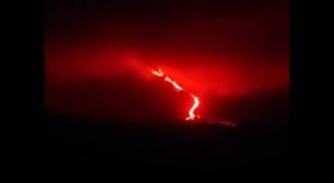
Lava continues to erupt at Great Sitkin Volcano. Satellite observations from this week show that lava is erupting from the vent area and spreading slowly south, with some rockfalls occurring along the south and east parts of the dome. The southeast half of the lava dome appears to be slightly inflating. All activity remains confined within the summit crater. Occasional small earthquakes, and signals related to rockfalls from the steep lava flow margins, continue to be detected in seismic data. A field crew conducted an overflight of the volcano this week to make observations and photograph the ongoing eruption.
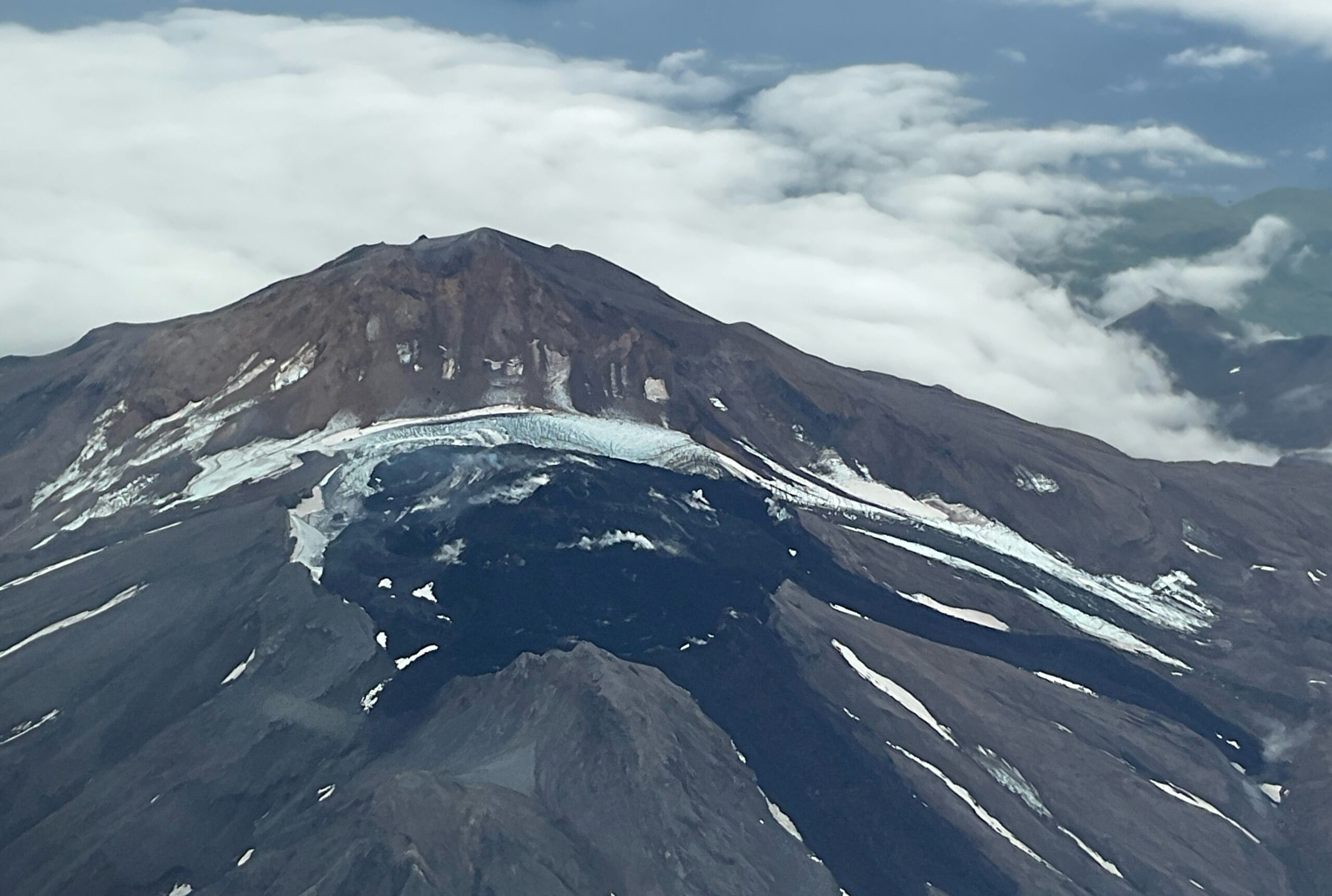
A close up view of the summit crater of Great Sitkin, taken from the air. The currently growing lava flow is steaming in places.
The current lava eruption began in July 2021 and has filled most of the summit crater and advanced into valleys below. There have been no explosions at Great Sitkin Volcano since an event in May 2021. The volcano is monitored using local seismic and infrasound sensors, satellite data and web cameras, and regional infrasound and lightning networks.
Source : AVO.
Photo : McConnell, Angela
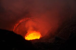
Colombia , Nevado del Ruiz :
Manizales, September 2, 2025, 4:45 a.m.
Regarding the monitoring of the activity of the Nevado del Ruiz volcano, the Colombian Geological Survey (SGC), an entity affiliated with the Ministry of Mines and Energy, reports that:
During the week of August 26 to September 1, 2025, the volcano continued to exhibit unstable behavior. Compared to the previous week, the main variations in the monitored parameters were:
– Seismicity related to fluid dynamics in volcanic conduits saw a decrease in the number of recorded earthquakes and an increase in the seismic energy released. This seismicity was mainly characterized by short-duration signals, with mostly low and, in some cases, moderate energy levels. The use of cameras (conventional or thermographic) used for monitoring the volcano has made it possible to confirm several pulsatile ash emissions, as well as variations in the apparent temperature of the materials emitted during these emissions.
Seismic activity associated with rock fracturing processes within the volcanic edifice maintained similar values in terms of the number of recorded earthquakes and increased in the released seismic energy. The earthquakes were located on the northeast flank (less than 3 km from the Arenas crater), within the crater itself, and scattered on the other flanks of the volcano (up to 6 km from the crater). The depth of the earthquakes ranged from less than 1 km to 8 km from the volcanic summit. The highest magnitude recorded during the week was 1.6, corresponding to the earthquakes that occurred on August 29 at 4:52 p.m. (Northeast sector) and on September 1 at 3:39 a.m. (South-Southwest sector) and at 10:20 a.m. (Arenas crater), at depths of 5 km, 4 km, and 1 km, respectively. The first event was located 2.7 km northeast of Arenas Crater and at a depth of 4.7 km; the second was located 3.6 km south-southwest of Arenas Crater and at a depth of 3.7 km; and the third was located in Arenas Crater, at a depth of 1.3 km.
All three events had a magnitude of 1.6.
– The emission of water vapor and volcanic gases, mainly sulfur dioxide (SO₂), into the atmosphere from Arenas Crater showed variability throughout the week. Estimated daily flows associated with SO₂ degassing decreased compared to those recorded the previous week, a trend also highlighted by satellite monitoring of this parameter.
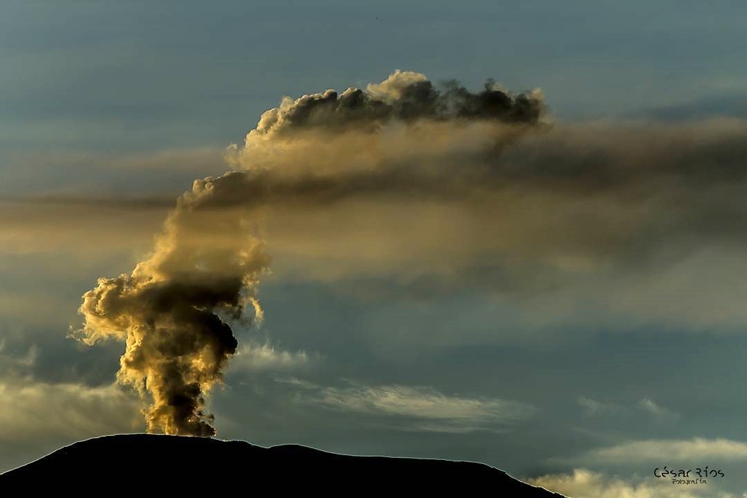
– The vertical height of the column of gas, water vapor, or ash reached 800 m above the volcano’s summit. During dispersal, the maximum height was estimated at approximately 1,800 m during ash emissions recorded on August 21 at 2:24 p.m., on August 26 at 12:53 a.m., and on August 30 at 5:12 p.m. Regarding the direction of dispersal, the column tended toward the northwest, west-northwest, and west-southwest of the volcano. Due to persistent winds in this direction and their high speed, ashfall occurred in the municipalities of Manizales, Villamaría, and Chinchiná, in the department of Caldas. This fall was related to the recorded ash emissions and, due to the strong winds at this time of year, to the remobilization of these materials.
– When monitoring thermal anomalies at the floor of the Arenas crater using satellite monitoring platforms, detection was limited by atmospheric conditions of high cloud cover in the volcanic area. However, some low energy anomalies have been reported.
Source : SGC
Photo : C. Rios ( archive)
La Martinique , Mount Pelée :
Weekly Report, Paris Institute of Earth Physics, Martinique Volcanological and Seismological Observatory
Saint-Pierre, September 5, 2025 at 4:30 p.m. local time (GMT-4)
Volcanic activity increased this week with 517 earthquakes of volcanic origin observed.
Between August 29, 2025 at 4:00 p.m. (UT) and September 5, 2025 at 4:00 p.m. (UT), the OVSM recorded:
• 506 volcano-tectonic earthquakes. Among them, 14 had a duration magnitude greater than Md = 0.5, and the largest had a magnitude Md = 0.8. The others were of lower energy. These earthquakes were clearly identified as originating from one of the well-known seismically active zones at Mount Pelée, located between 1.0 and 1.4 km deep below the volcano’s summit.
The shallow volcano-tectonic seismicity is associated with microfracturing in the volcanic edifice, linked to the global reactivation of the volcano observed since 2019.
• Six shallow hybrid earthquakes, with a maximum local magnitude of Mlv = 1.05, located approximately 1 km deep beneath the domes of Mount Pelée in the same area as the volcano-tectonic earthquakes. The hybrid seismic signals are enriched in low frequencies and are associated with the circulation of fluids (gas, hydrothermal fluids) within the volcanic edifice.
• Five deep long-period earthquakes, four of which were located in the vicinity of Mount Pelée. Their local magnitudes ranged between Mlv = 0.5 and Mlv = 0.9. Three of these earthquakes occurred at depths between 18 and 29 km, and one was preliminarily located at a depth of 10 km. Deep long-period earthquakes are characterized by signals that contain only low frequencies and are associated with the circulation of magmatic fluids deep within the Mount Pelée volcanic system.
No earthquakes were felt by the population.
The previous week, the OVSM recorded 369 volcanic earthquakes. As of September 5, 2025, and over the past four weeks, the OVSM has observed a total of 1,763 volcanic earthquakes, an average of 440 to 441 earthquakes per week.
During phases of volcanic reactivation in volcanoes similar to Mount Pelée, it is common to observe seismic activity of varying intensity and frequency.
For more details on observations and interpretations of volcanic activity over the longer term, refer to the OVSM’s monthly bulletins.
The alert level is currently YELLOW: vigilance.
Source : Direction de l’OVSM-IPGP.
Photo : tameteo.com
Italy , Vulcano :
MONTHLY BULLETIN, REFERENCE MONTH AUGUST 2025. (Publication date: September 2, 2025)
ACTIVITY STATUS SUMMARY
Monitoring data highlights the following:
1) Crater fumarole temperature: Increased fumarole temperatures, up to a maximum temperature of 291°C
2) CO2 flux in the crater area: Beginning on August 1, a sharp increase in CO2 flux from the ground (VSCS) was observed. The anomalous values persisted throughout the month.
3) SO2 flux in the crater area: SO2 flux at moderate to high levels
4) Fumarolic gas geochemistry: Increased CO2 in the composition of the crater fumaroles.

5) CO2 flux at the base of the La Fossa cone and in the Vulcano Porto area: Degassing sites at the base of the cone show an increase in CO2 flux at the end of August.
6) Thermal aquifer geochemistry: During the second half of August, an increase in temperature was observed in the Camping Sicilia well and a slight rise in the water table in the Bambara well.
7) Local seismicity: Increased occurrence rate of local microseismicity.
8) Regional seismicity: Low seismic activity due to fracturing.
9) Deformations – GNSS: The GNSS network highlighted an increase in surface variation in the IVCR-IVLT-IVUG triangle.
10) Deformations – Inclinometry: No changes were observed at the SLT stations. 11) Gravimetry: No updates were available during the observation period; the latest data do not indicate significant medium- and long-term changes in the gravitational field.
LOCAL SEISMICITY
August was characterized by an increase in seismic activity related to hydrothermal fluid dynamics, resulting in an increase in the frequency of typical local seismic events, both high-frequency (spectral peak above 1 Hz) and low-frequency (spectral peak below 1 Hz). This increase in frequency, which began on August 1st, developed mainly during the first half of the month and recorded the highest occurrence rates from August 6th to 8th.
During the second half of the month, the number of microshocks decreased significantly, but to date, the occurrence rate of events remains higher than that recorded during the months preceding this latest phase of increased seismicity.
Source et photo : INGV.