August 2 , 2025 .
Indonesia , Lewotobi Laki-laki :
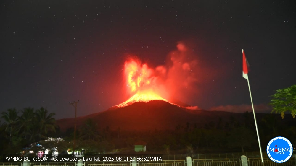
LEWOTOBI LAKI-LAKI ACTIVITY LEVEL IV (AWAS) ACTIVITY AUGUST 1, 2025
The volcano is clearly visible until shrouded in thick fog. White smoke of low to moderate intensity is emitting from the main crater, approximately 100-500 meters from the summit.
Seismic data from July 30 and 31, 2025, at 6:00 a.m. (Central Indonesian Time), include one seismic tremor, 19 nonharmonic tremors, one low-frequency earthquake, one deep volcanic earthquake, four local tectonic earthquakes, and three distant tectonic earthquakes.
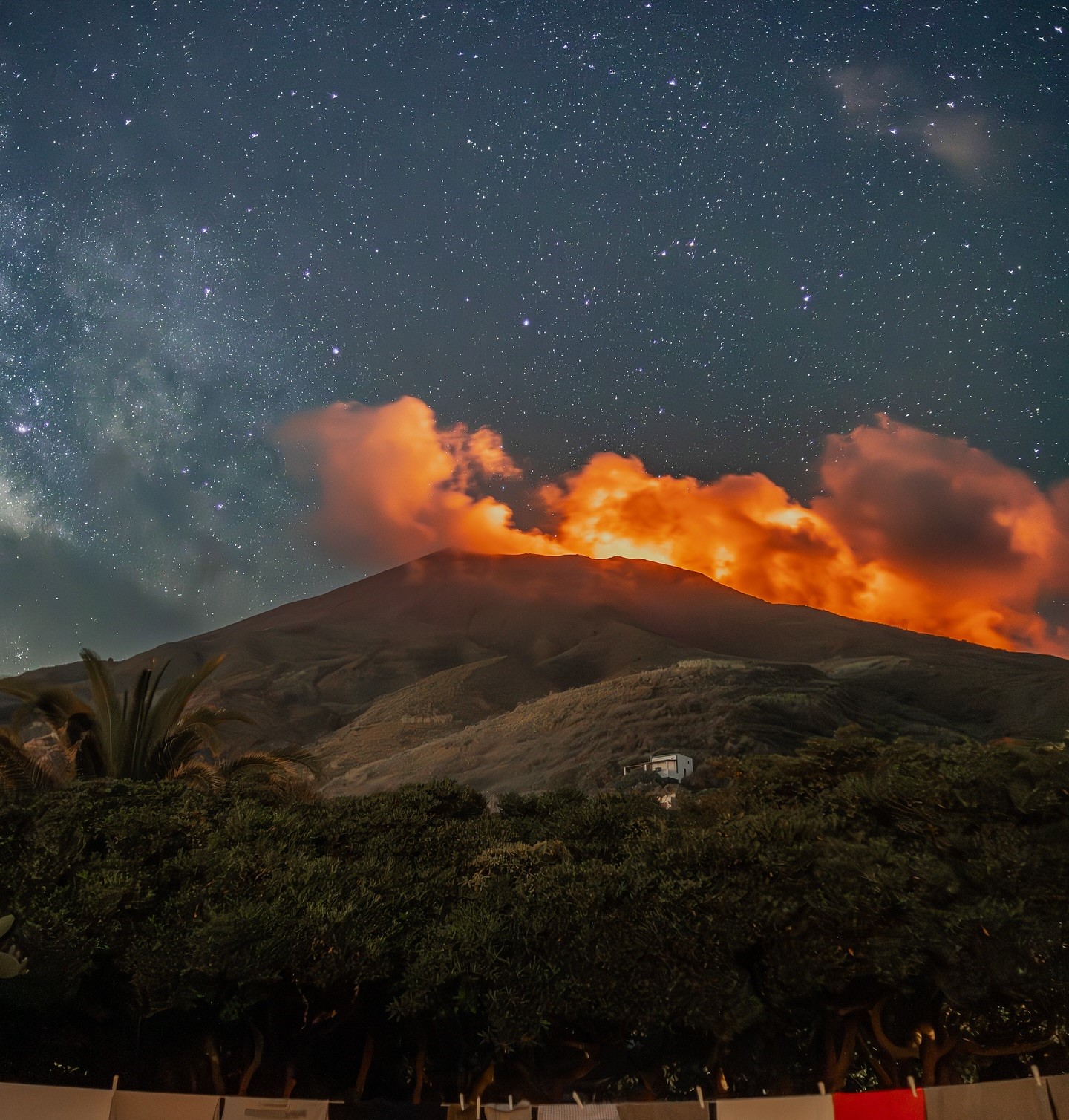
Thick white smoke was observed at several points on the crater surface or summit slopes, likely due to water vapor and volcanic gases such as sulfur. The crater surface appears to be dominated by dark gray rocks from previous eruptions, with some areas exhibiting brownish to reddish hues, indicating the presence of hot material or discoloration due to oxidation. At night, a red glow is visible around the summit, indicating the presence of hot or glowing material near the crater. Visual observations indicate that the thick white smoke emitted from the crater is composed primarily of water vapor, indicating high temperatures in the summit area.

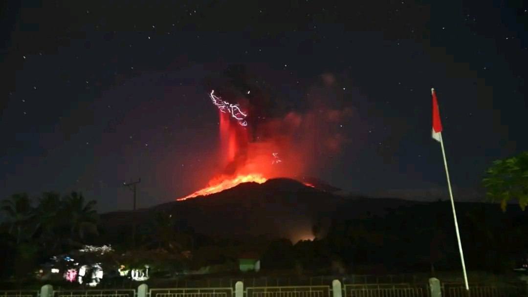
An eruption occurred at Mount Lewotobi Laki-laki on Friday, August 1, 2025, at 8:48 PM WITA. The observed ash column rose approximately 10,000 m above the summit (approximately 11,584 m above sea level). The ash column was gray and dense, oriented toward the west and northwest. At the time of writing, the eruption was still ongoing.
Seismic data show a significant increase in volcanic earthquakes on August 1, 2025, starting at 6:00 PM WITA (Central Indonesian Time), including an increase in nonharmonic tremor. This indicates that magmatic activity remains strong at shallow depths near the surface. This situation may increase the risk of explosive and effusive eruptions. Furthermore, magma is observed to continue to move from the depths to the surface. This requires increased vigilance, as it could trigger sudden changes in activity.
Deformation data show that Global Navigation Satellite System (GNSS) monitoring results continue to record deflationary patterns over the past five days, indicating magma migration from depth to shallower areas. This indication is reinforced by a downward trend in tiltmeter data over the same period. The tiltmeter location is closer to the crater, within a radius of approximately 4 km, while the GNSS station is approximately 6.5 km from the crater. The combination of these two deformation data points to an increase in pressure in the gas-rich conduit and magma migration from shallow depths to the surface, which could lead to an explosive eruption.
Based on visual and instrumental analyses, the activity of Mount Lewotobi Laki-laki remains high. Consequently, the activity level of Mount Lewotobi Laki-laki remains at Level IV (SIAGA), with the following recommendations: the public and tourists are advised to avoid all activity within a 6 km radius and a 7 km radius southwest-northeast of the eruption epicenter, to remain calm, and to follow the instructions of local authorities. The public is also asked to disregard information from unreliable sources.
Furthermore, residents in at-risk areas are advised to be aware of the risk of lahars during heavy rainfall, particularly in river basins originating at the summit of Mount Lewotobi Laki-laki, such as Nawakote, Dulipali, Nobo, Hokeng Jaya, and Nurabelen. Residents affected by ashfall are advised to wear a mask or cover their nose and mouth to protect their respiratory tract.
Source : PVMBG
Photos : Magma Indonésie
Kamchatka , Klyuchevskoy :
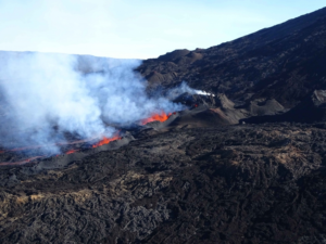
The Kamchatkan Volcanic Eruption Response Team (KVERT) reported that eruptive activity at Klyuchevskoy’s summit crater continued during 17-30 July. A strong thermal anomaly was identified in satellite images. Lava had been slowly filling up the crater since 20 April; according to Kamchatka Volcanological Station (Volkstat), bright crater incandescence observed on 19 July by scientists visiting the area confirmed that a significant amount of new lava was present in the summit crater. At 23h24 on 29 July a M 8.8 tectonic earthquake occurred about 400 km S and was unrelated to the ongoing eruption. At 23h50 on 29 July an ash plume was identified in a satellite image extended 58 km E. A satellite image captured at around 00h36 on 30 July showed a large lava flow had already descended the WSW flank. The Aviation Color Code remained at Orange (the second highest level on a four-color scale). Dates are based on UTC times; specific events are in local time where noted.
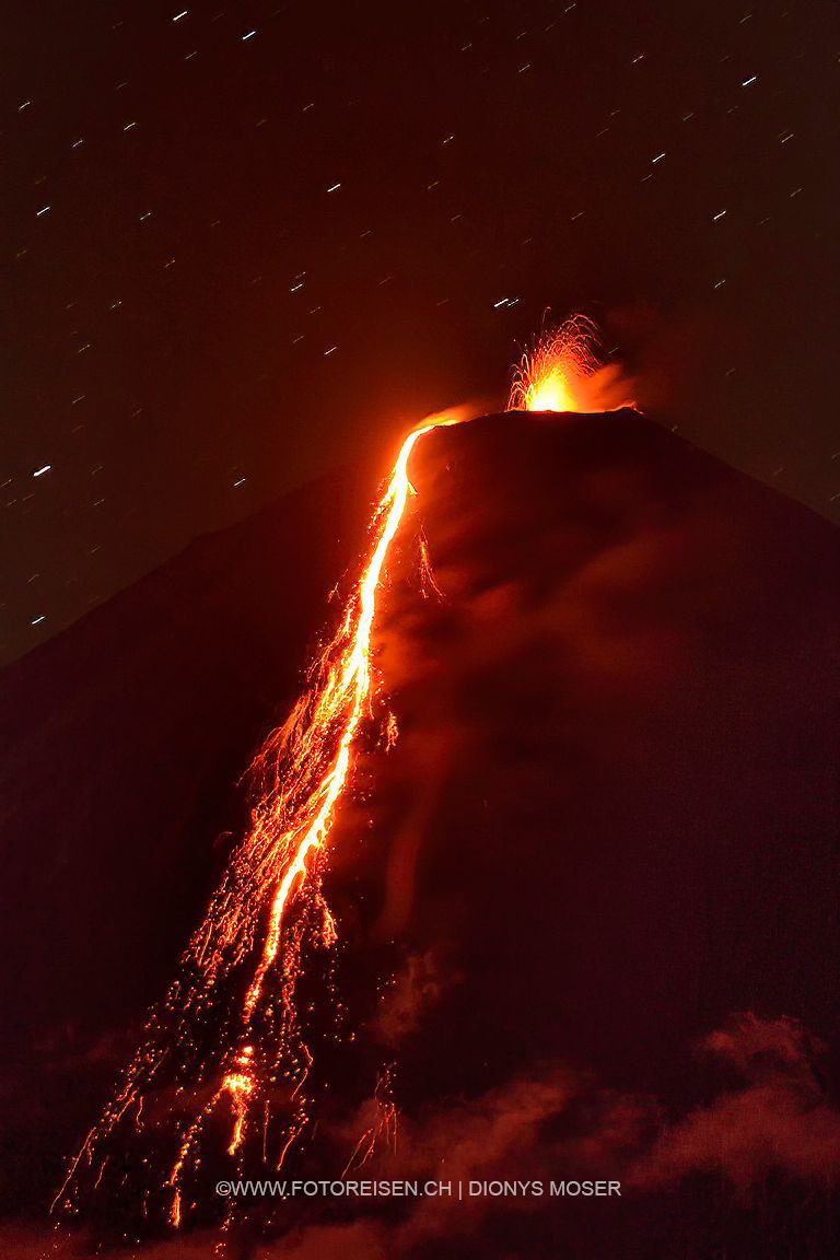
Klyuchevskoy is the highest and most active volcano on the Kamchatka Peninsula. Since its origin about 6,000 years ago, this symmetrical, basaltic stratovolcano has produced frequent moderate-volume explosive and effusive eruptions without major periods of inactivity. It rises above a saddle NE of Kamen volcano and lies SE of the broad Ushkovsky massif. More than 100 flank eruptions have occurred during approximately the past 3,000 years, with most lateral craters and cones occurring along radial fissures between the unconfined NE-to-SE flanks of the conical volcano between 500 and 3,600 m elevation. Eruptions recorded since the late 17th century have resulted in frequent changes to the morphology of the 700-m-wide summit crater. These eruptions over the past 400 years have originated primarily from the summit crater, but have also included numerous major explosive and effusive eruptions from flank craters.
Sources: Kamchatkan Volcanic Eruption Response Team (KVERT), Kamchatka Volcanological Station, Copernicus, GVP.
Photo : Dionys Moser via FB.
Iceland , Reykjanes Peninsula :
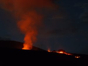
The Icelandic Meteorological Office (IMO) reported that a fissure within the Reykjanes volcanic system that began erupting on 16 July in an area NE of Stóra Skógfell, along the Sundhnúkur crater row, continued to erupt during 23-29 July. Measurements of the flow field taken on 23 July indicated that the total volume of new lava in the Sundhnúkur area was estimated to be 26.8 million cubic meters and covered an estimated 3.3 square kilometers. One crater continued to produce lava flows and periodic spatter; activity at the crater declined during the mornings of 23 and 24 July and then remained stable during the rest of the week. A small vent opened on the W flank of the crater’s cone on 28 July but was inactive by 29 July.
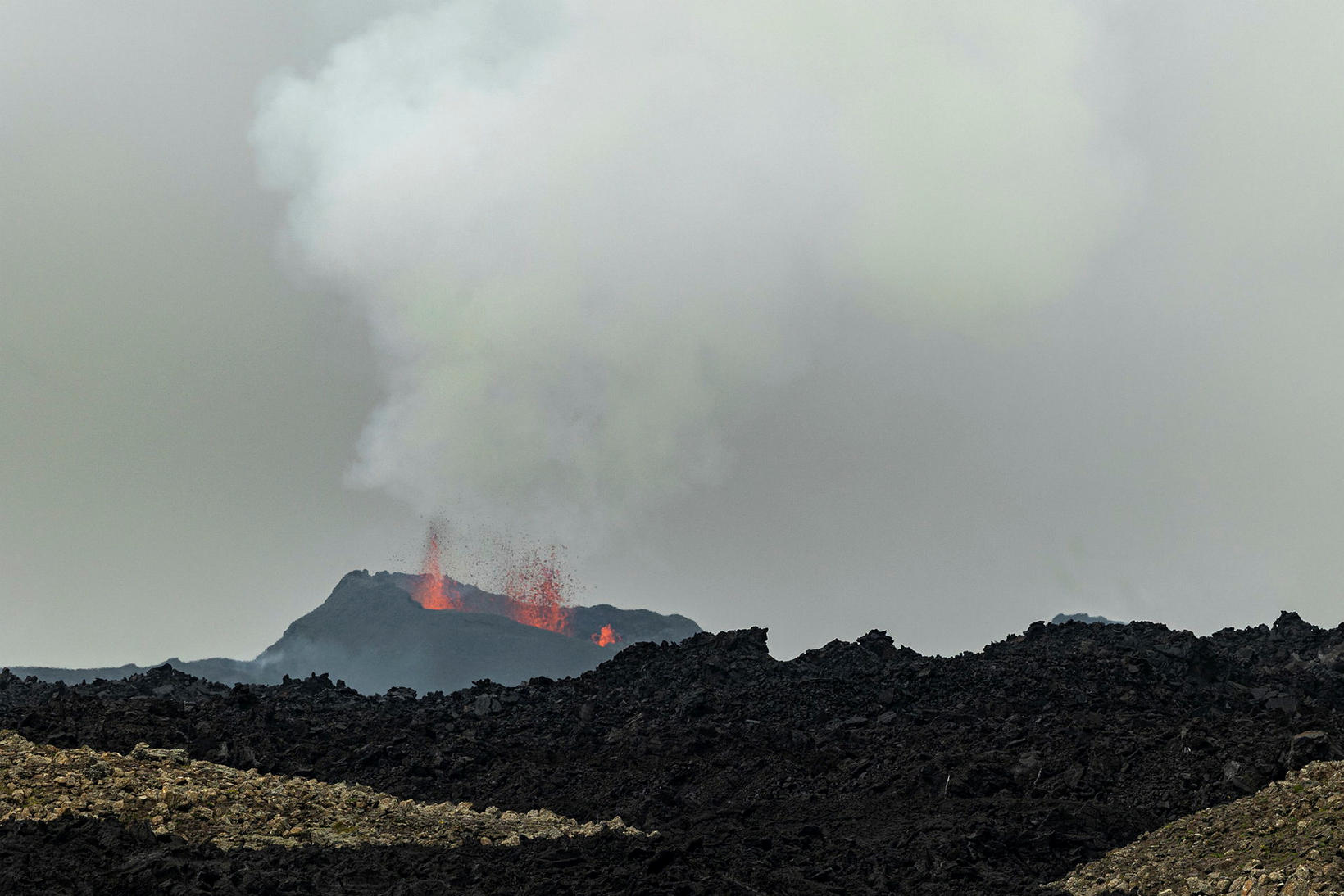
During 28-29 July a new crater formed inside the main crater and became the center of the activity. Lava flowed E and SE. The flow thickened with only minor changes to the flow margins; a small breakout at the SE part of the flow traveled a short distance S. Sulfur dioxide emissions significantly decreased during 23-24 July, though on 24 July volcanic smog (vog) was widely reported, including in Ísafjörður (about 240 km N) and Strandir (about 200 km NNE). A small amount of vog was detected in some areas overnight during 24-25 July. Gas emissions during 28-29 July drifted over populated areas in SW Iceland.
Sources: Icelandic Meteorological Office (IMO) , GVP.
Photo : mbl . is / Karítas.
Italy / Sicily , Etna :
WEEKLY BULLETIN, July 21-27, 2025. (Publication date: July 29, 2025)
ACTIVITY SUMMARY
Based on monitoring data, the following points are highlighted:
1) VOLCANOLOGICAL OBSERVATIONS: Variable-rate degassing activity in the summit craters. Sporadic and weak ash emissions in the Southeast Crater.
2) SEISMOLOGICAL: Absence of seismic activity due to fracturing with Ml >=2.0. Medium to low-level tremor amplitude.
3) INFRASOUND: Weak infrasound activity. In addition to the usual activity in the Northeast Crater, infrasound signals from the Southeast Crater resumed during the week. 4) GROUND DEFORMATION: No significant changes were reported in the time series of ground deformation monitoring networks.
5) GEOCHEMISTRY: SO2 fluxes at low levels.
Soil CO2 fluxes (EtnaGas Network): Average values.
Dissolved CO2 in groundwater (EtnaWater Network): No updates.
He isotope ratio at peripheral sites: The latest data from July 18 were high.
6) SATELLITE OBSERVATIONS: Thermal activity observed by satellite in the summit area was generally low.
VOLCANOLOGICAL OBSERVATIONS
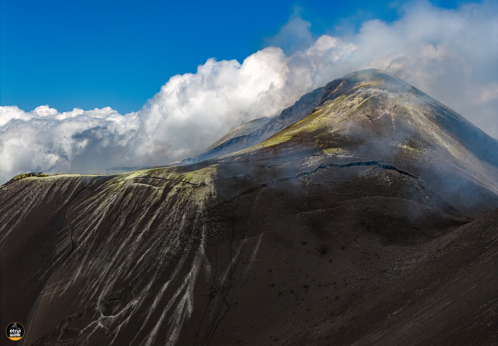
Monitoring of Mount Etna’s volcanic activity was carried out through the analysis of images from the INGV’s surveillance camera network, Osservatorio Etneo (INGV-OE), and through an inspection conducted on July 25 by INGV staff.
During the period studied, Etna’s activity was characterized by degassing of varying intensity and speed at the summit craters.
In particular, during the July 25 inspection, the Northeast Crater (CNE) produced intense degassing from a vent located at the crater floor; the Southeast Crater (CSE) was affected by widespread degassing from several fumaroles along the flanks and summit of the cone. Furthermore, analysis of camera images showed that, during the period analyzed, the CSE produced sporadic ash emissions that rapidly dispersed into the atmosphere.
Finally, widespread fumarolic degassing was observed in the Voragine crater (VOR). The Bocca Nuova crater (BN) showed degassing generated by pit craters at its floor.
Source : INGV
Photo : Etna Walk via FB.
Italy , Stromboli :
WEEKLY BULLETIN, July 21-27, 2025. (Publication date: July 29, 2025)
ACTIVITY SUMMARY
Based on monitoring data, the following points are highlighted:
1) VOLCANOLOGICAL OBSERVATIONS: Regular eruptive activity of medium frequency in the northern crater area and low frequency in the central-southern area. The average total frequency was 10.6 events/hour, with low intensity and episodes of medium intensity in the northern area and low intensity in the central-southern area.
2) SEISMOLOGY: The monitored seismic parameters show no significant variation.
3) GROUND DEFORMATION: No significant variation is detected in the ground deformation data.
4) GEOCHEMISTRY: SO2 flux is medium to low. The CO2 flux from the ground in the Pizzo area (STR02) is high.
The C/S ratio in the plume is high.
The helium isotope ratio (R/Ra) dissolved in the thermal aquifer is high.
The CO2 flux from the ground in the Scari area is high.
5) SATELLITE OBSERVATIONS: Thermal activity observed by satellite in the summit area was generally low, with some isolated moderate thermal anomalies.
VOLCANOLOGICAL OBSERVATIONS
During the observation period, Stromboli’s eruptive activity was characterized by analyzing images recorded by INGV-OE surveillance cameras located at an altitude of 190 m (SCT-SCV) and at Punta dei Corvi (SPCT). Explosive activity was mainly produced by four eruptive vents located in the North Crater area and by at least two vents located in the Central-South Crater area.
Observations of explosive activity captured by surveillance cameras
The eruptive activity observed in the North Crater area (N) was produced by four active vents with the emission of mainly coarse products (bombs and lapilli). The explosions were of low intensity (the eruptive products reached a height of less than 80 m) and, at times, of medium intensity (the eruptive products were between 80 and 150 m). The average explosion frequency was approximately 8.0 events/hour (Fig. 3.1).
In the South-Central (SC) area, explosive activity was modest, with the emission of fine particles. The average explosion frequency was approximately 2.6 events/hour.
Source : INGV
Photo : Stromboli stati d’animo / Sebastiano Cannavo