July 5 , 2025.
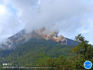
Alaska , Spurr :
Unrest continues at Mount Spurr. The level of activity remains slightly above background but continues to decline since the peak of unrest earlier this year. The decrease in activity suggests that the magma intrusion beneath Mount Spurr has stalled and that the likelihood of an eruption has declined.
Earthquake activity continues, with a small number located beneath the summit of Mount Spurr and beneath Crater Peak. The number of earthquakes and their magnitudes continue to show some variability from week to week but are following a decreasing trend. Ground deformation, as measured by GNSS (GPS) stations, remains paused as it has for the last two months. Volcanic gas emissions continue, as would be expected from a passively degassing body of stalled magma.
Fluctuations in unrest are common at volcanoes and eruptive activity remains possible, but unlikely. Should unrest escalate towards an eruption, we expect to observe increases in seismic activity, gas emissions, surface deformation, and surface heating
AVO continues to closely monitor activity at Mount Spurr for signals indicating the volcano is moving closer to an eruption using local seismic, infrasound, and GNSS (GPS) stations, web cameras, airborne and satellite gas measurements, regional infrasound, lightning networks, and satellite images.
Source : AVO
Photo : Loewen, Matt / Alaska Volcano Observatory / U.S. Geological Survey.
Hawaii , Kilauea :
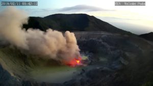
Friday, July 4, 2025, 7:15 AM HST (Friday, July 4, 2025, 17:15 UTC)
19°25’16 » N 155°17’13 » W,
Summit Elevation 4091 ft (1247 m)
Current Volcano Alert Level: WATCH
Current Aviation Color Code: ORANGE
Activity Summary:
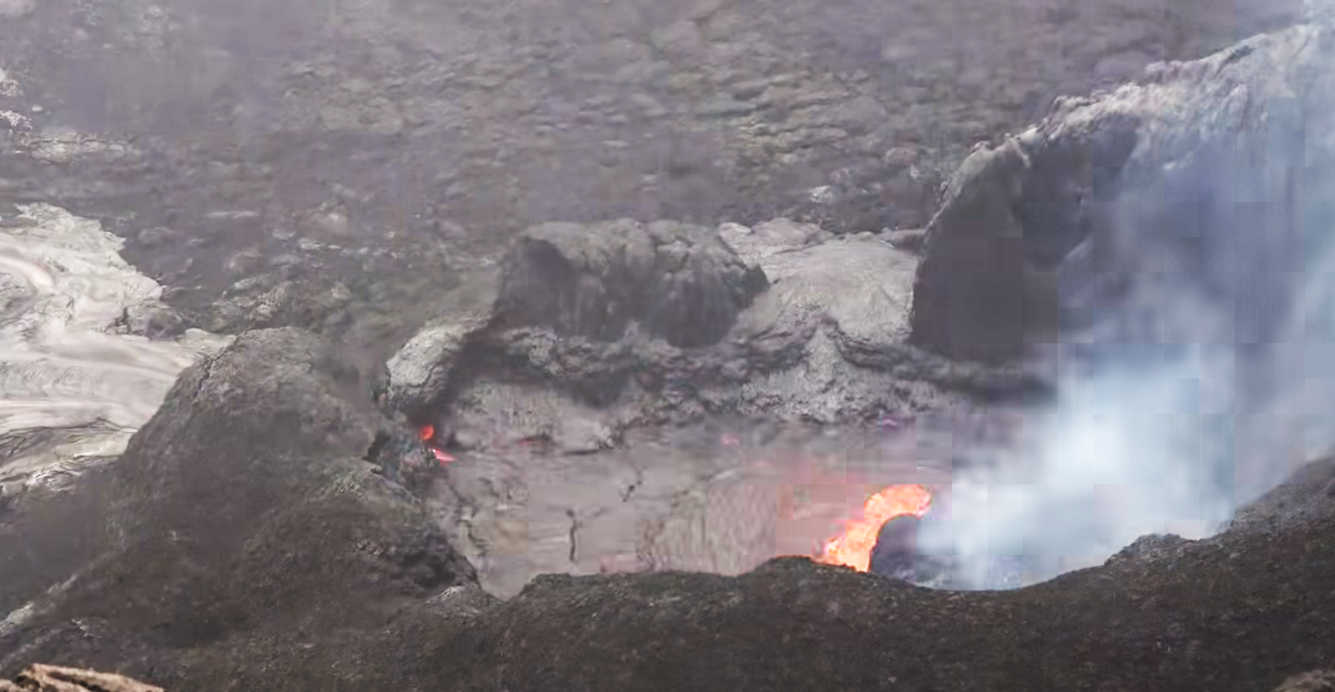
The ongoing Halemaʻumaʻu eruption is paused. The end of episode 27 on June 29 at 7:54 p.m. HST coincided with a switch from deflationary tilt to inflationary tilt at the summit and a decrease in seismic tremor intensity. Summit inflation continues at this time, along with persistent, low-level seismic tremor. Incandescent glow has been visible at the north vent in overnight webcam views, as well as intermittent minor lava spattering this morning. These observations indicate that another lava fountaining episode is probable, and the current summit inflation rate suggests it will occur sometime between July 7 and 11, with July 7–9 being the most likely. This window is subject to change due to variations in the summit inflation rate and other factors, and it will be refined as more data become available.
Fountaining episodes have occurred approximately once per week since the start of the current eruption on December 23, 2024. All eruptive activity remains within Hawaiʻi Volcanoes National Park, and no significant activity has been noted along Kīlauea’s East Rift Zone or Southwest Rift Zone.
Summit Observations:
At the north vent in Halemaʻumaʻu within the western part of Kaluapele (Kīlauea caldera), incandescent glow has been visible in overnight webcam views since shortly after episode 27, and intermittent minor lava spattering was observed at the same location several times early this morning. Rockfalls from the vent’s spatter deposit on the crater wall have exposed other spots of incandescence.
The tiltmeter near Uēkahuna (UWD) has recorded approximately 10 microradians of inflationary tilt since the end of episode 27. UWD recorded more than 16 microradians of deflationary tilt during the fountaining episode. Seismic tremor persists at low levels beneath Halemaʻumaʻu crater.
Source et photo : HVO ( capture d’écran)
Indonesia , Ibu :
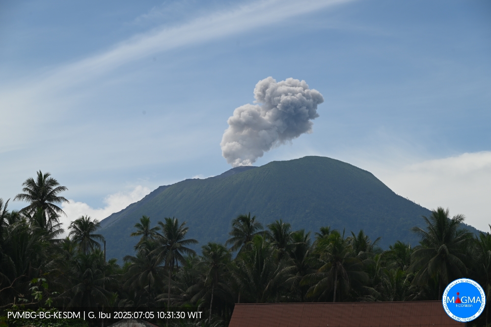
An eruption of Mount Ibu occurred on Saturday, July 5, 2025, at 9:58 a.m. (local time). The observed ash column was ± 600 m above the summit (± 1925 m above sea level). The ash column was white to gray, with intense intensity, oriented toward the Southeast. This eruption was recorded by seismograph with a maximum amplitude of 14 mm and a duration of 46 seconds.
Seismicity Observation:
112 eruption earthquakes with amplitudes ranging from 11 to 28 mm and durations ranging from 31 to 77 seconds.
11 emission earthquakes with amplitudes ranging from 2 to 9 mm and durations ranging from 30 to 42 seconds.
24 harmonic tremors with amplitudes ranging from 2 to 28 mm and durations ranging from 29 to 116 seconds.
70 low-frequency earthquakes with amplitudes ranging from 2 to 11 mm and durations ranging from 16 to 27 seconds.
229 shallow volcanic earthquakes with amplitudes ranging from 2 to 12 mm and durations ranging from 7 to 20 seconds.
2 deep volcanic earthquakes with amplitudes ranging from 2 to 3 mm and durations ranging from 12 to 14 seconds. Four local tectonic earthquakes with amplitudes ranging from 2 to 26 mm and lasting from 25 to 52 seconds.
Fifteen distant tectonic earthquakes with amplitudes ranging from 2 to 28 mm and lasting from 35 to 231 seconds.
Recommendations
1. Residents of the vicinity of Mount Ibu and visitors/tourists should refrain from carrying out any activities within a 2 km radius and a 3.5 km sectoral extension towards the crater opening, in the northern part of the active crater of Mount Ibu.
2. In the event of ash rain, people carrying out activities outside their homes are advised to wear face masks and protective eyewear.
Source et photo : Magma Indonésie .
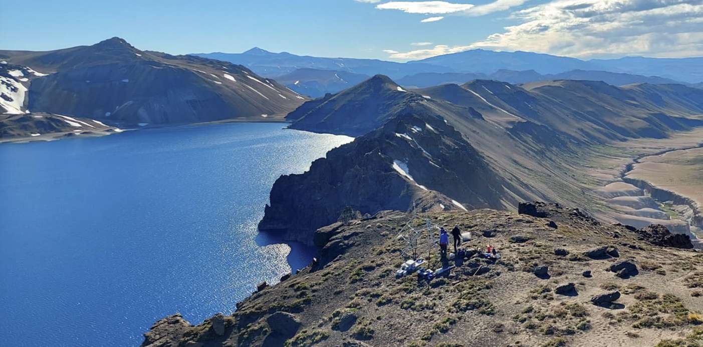
Chile , Laguna del Maule :
Seismology
Seismological activity during this period was characterized by:
6,640 VT-type earthquakes, associated with rock fracturing (volcano-tectonics). The most energetic earthquake, with a local magnitude (LM) of 3.0, was located 5.4 km north-northwest of the volcanic edifice, at a depth of 4.4 km from the center of the lagoon.
36 LP-type earthquakes, associated with fluid dynamics within the volcanic system (long period). The magnitude of the largest earthquake, estimated using the reduced displacement (RD) parameter, was 20 cm².
Fluid Geochemistry
No anomalies in sulfur dioxide (SO₂) emissions into the atmosphere were reported near the volcanic complex, according to data published by the Tropospheric Monitoring Instrument (TROPOMI) and the Sulfur Dioxide Monitoring Group of the Ozone Monitoring Instrument (OMI).
Satellite Thermal Anomalies
During the period, no thermal anomalies were recorded in the area associated with the volcanic complex, based on analytical processing of Sentinel 2-L2A and LandSat 8 satellite images, combined with thermal bands and false color.
Geodesy
Geodetic activity for the period was characterized by:
– High rates of change (1.5 cm/month) of horizontal components at the MAU2 station.
This rate is higher than the typical historical parameters observed in the volcanic complex.
– An increase in rates of change of vertical components at GNSS stations compared to the previous month, with a maximum of 2.7 cm/month observed at the MAU2 station, a value considered historically high, but lower than expected from the inflation process underway since before 2012.
– The rate of lengthening/shortening of the monitoring line (distance between GNSS stations) is considered high, reaching 2.6 cm/month.
– Radar interferometry is unable to determine deformation patterns or amplitudes due to the low image coherence caused by the region’s heavy snow cover. Consequently, the inflationary process within the complex continues, with values slightly above the historical average measured geodetically.
Activity has remained at levels considered low, suggesting stability of the volcanic complex. The technical volcanic alert remains in effect:
GREEN TECHNICAL ALERT: Active volcano with stable behavior – No immediate risk
Source : Sernageomin .
Photo : neuqueninforma.gob.ar
Colombia , Galeras :
San Juan de Pasto, July 1, 2025, 4:40 p.m.
Regarding the monitoring of the activity of the Galeras Volcano, the Colombian Geological Survey (SGC), an entity affiliated with the Ministry of Mines and Energy, reports that:
During the week of July 24 to 30, 2025, the main variations in the monitored parameters compared to the previous week were:
● A decrease in seismic activity was observed, while the energy released remained relatively stable. Seismic activity associated with rock fracturing processes within the volcano continued to predominate.
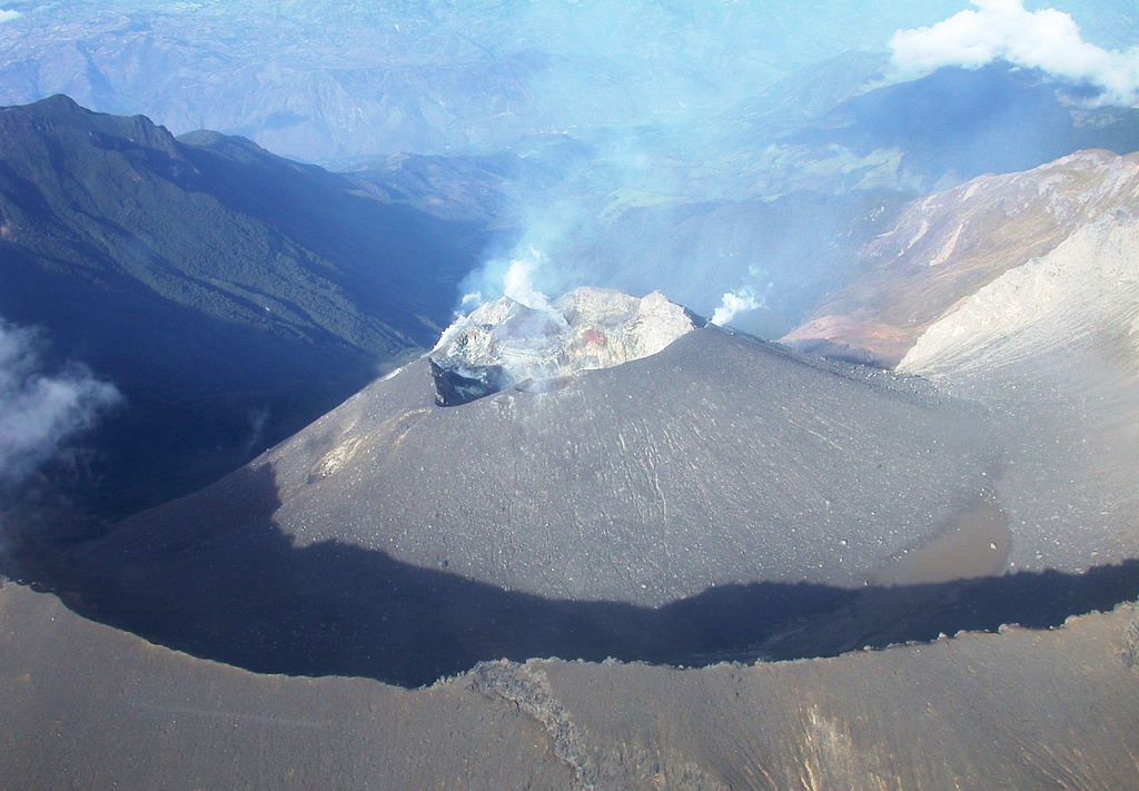
● Some earthquakes were located near the main crater, while others were scattered throughout the volcanic edifice, at distances of up to 12 km, at depths between 0.5 and 14 km from the summit (4,200 m above sea level), and with a maximum magnitude of 1.4.
● Low-altitude white gas columns, with variable dispersion depending on the wind, were observed emanating from the fumarole fields of El Paisita, to the north, and Las Chavas, to the west of the active cone.
● Other volcanic monitoring parameters remained stable.
Based on the above, the SGC recommends closely monitoring developments through weekly bulletins and other information published through our official channels, as well as instructions from local and departmental authorities and the National Disaster Risk Management Unit (UNGRD).
Volcanic activity remains on alert. Yellow: Active volcano with changes in the basic behavior of monitored parameters and other manifestations.
Source et photo: SGC.