March 17 , 2025 .
Indonesia , Dukono :
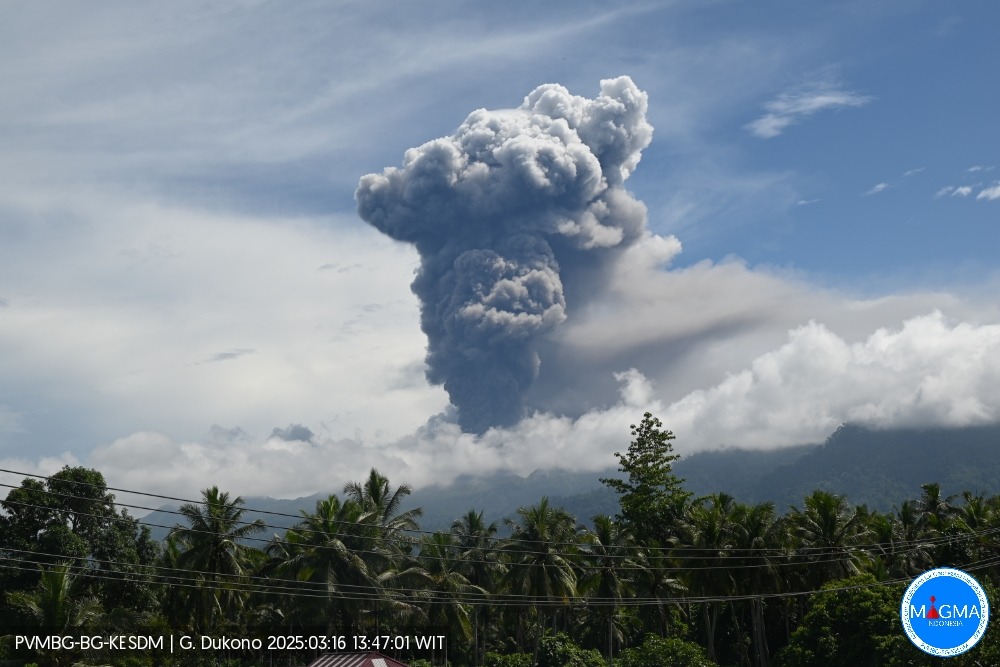
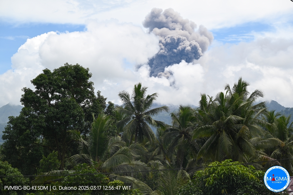
An eruption of Mount Dukono occurred on Sunday, March 16, 2025, at 2:42 PM WIT with an observed ash column height of ± 3100 m above the peak (± 4187 m above sea level). The ash column was observed to be gray in color with a thick intensity, oriented toward the west and northwest. At the time of writing, the eruption was still ongoing.
VOLCANO OBSERVATORY NOTICE FOR AVIATION – VONA
Issued : March 16 , 2025
Volcano : Dukono (268010)
Current Aviation Colour Code : ORANGE
Previous Aviation Colour Code : orange
Source : Dukono Volcano Observatory
Notice Number : 2025DUK034
Volcano Location : N 01 deg 41 min 35 sec E 127 deg 53 min 38 sec
Area : North Maluku, Indonesia
Summit Elevation : 3478 FT (1087 M)
Volcanic Activity Summary :
Eruption with volcanic ash cloud at 05h42 UTC (14h42 local).
Volcanic Cloud Height :
Best estimate of ash-cloud top is around 13398 FT (4187 M) above sea level or 9920 FT (3100 M) above summit. May be higher than what can be observed clearly. Source of height data: ground observer.
Other Volcanic Cloud Information :
Ash cloud moving to northwest. Volcanic ash is observed to be gray. The intensity of volcanic ash is observed to be thick.
Remarks :
Eruption and ash emission is continuing. Eruption recorded on seismogram with maximum amplitude 3 mm. Tremor recorded on seismogram with maximum amplitude 34 mm.
Currently, Dukono’s volcanic activity is centered in the Malupang Warirang crater at an altitude of 1,086 meters above sea level. The currently intense eruptions are explosive magmatic eruptions.
In 2025, Mount Dukono’s volcanic activity level is quite high. This has been monitored by the relatively high number of eruption events, ranging from 60 to 394 events, or an average of 227 events per day, with the height of the eruption column ranging from 200 to 2,500 meters above the peak. On March 16, 2025, at 2:42 PM WIT, the height of the eruptive column was observed at 3,100 meters above the peak (4,187 meters above sea level). The eruptive column was observed to be gray in color with a thick intensity, oriented towards the West and Northwest.
According to the assessment of the Center for Volcanology and Geological Disaster Mitigation (PVMBG), part of the Geological Agency of the Ministry of Energy and Mineral Resources, Mount Dukono is currently still at Activity Level II (WASPADA), with a recommended safe distance outside a 4 (four) km radius from the activity center.
The potential hazards from Mount Dukono around the crater at this time include rock throwing around the summit and ash rain in villages located in the western and eastern sectors, depending on the wind direction and speed around the summit of Mount Dukono. In addition, secondary hazards in the form of lahar flows can occur during the rainy season along the Mamuya River (northern sector). The Mede and Tauni Rivers (northeast sector), which originate at the summit of Mount Dukono, should also be alerted to the risk of lahars.
The activity level of Mount Dukono is at level II (WASPADA),
Sources : Magma Indonésie , PVMBG
Photos : Magma Indonésie.
Alaska , Katmai :
ALASKA VOLCANO OBSERVATORY INFORMATION STATEMENT , U.S. Geological Survey, Sunday, March 16, 2025, 6:47 AM AKDT (Sunday, March 16, 2025, 14:47 UTC)
58°16’44 » N 154°57’12 » W,
Summit Elevation 6716 ft (2047 m)
Current Volcano Alert Level: NORMAL
Current Aviation Color Code: GREEN
Strong northwesterly winds in the vicinity of Katmai and the Valley of Ten Thousand Smokes have picked up loose volcanic ash erupted during the 1912 Novarupta-Katmai eruption and are carrying it to the southeast toward Kodiak Island. The National Weather Service has issued a SIGMET for this low-level event and suggests that the maximum cloud height is 6,000 ft (1.8 km) above sea level.
View of Griggs and Katmai Volcanoes from the north, en route to Cold Bay aboard a commercial flight on July 22, 2024.
This phenomenon is not the result of recent volcanic activity and occurs during times of high winds and dry snow-free conditions in the Katmai area and other young volcanic areas of Alaska. No eruption is in progress. All of the volcanoes of the Katmai area (Griggs, Katmai, Novarupta, Mageik, Martin, Snowy and Trident) remain at Aviation Color Code GREEN and Alert Level NORMAL. Resuspended volcanic ash should be considered hazardous and could be damaging to aircraft and health.
Source : AVO
Photo : Izbekov, Pavel / AVO/UAF-GI.
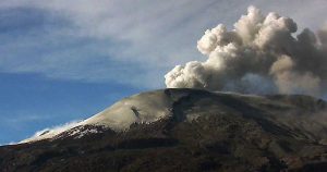
Chile , Lascar :
Special Volcanic Activity Report (REAV), Antofagasta Region, Láscar Volcano. March 16, 2025, 1:30 p.m. local time (Continental Chile)
The National Geology and Mining Service of Chile (Sernageomin) publishes the following information, obtained using the monitoring equipment of the National Volcanic Monitoring Network (RNVV), processed and analyzed at the Southern Andean Volcanological Observatory (OVDAS).
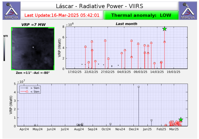
Today, Sunday, March 16, the Mirova platform (https://www.mirovaweb.it) reported a 7 MW satellite thermal anomaly, detected by the VIIRS sensor, originating from the active crater (Figure ). This value corresponds to the highest recorded value in the last month. In turn, Sentinel 2-L2A satellite images updated to the date of this report continue to record three areas of thermal radiation inside the active crater, since February 6 of this year.
Surveillance cameras installed around the volcano recorded whitish degassing, with no pyroclastic emissions. Furthermore, the seismic network installed on the volcano has recorded a decrease in Long Period (LP) volcanic seismicity since early February.
The volcano is in a state of surface activity instability, which could potentially lead to the occurrence of minor explosions with limited impact to the proximal area of the active crater, and to the emission of pyroclastic material from low-energy eruptive columns.
The technical alert for this volcanic system remains at yellow alert:
Sernageomin continues its online monitoring and multi-parameter tracking of the Lascar volcano and promptly reports any significant changes in volcanic activity via official communication channels.
Source : Sernageomin
Photos : Myguidechile . com , Capture d’écran Sernageomin.
Ecuador , El Reventador .
DAILY STATUS REPORT OF REVENTADOR VOLCANO, Sunday, March 16, 2025.
Information Geophysical Institute – EPN.
Surface Activity Level: High, Surface Trend: No change
Internal Activity Level: Moderate, Internal Trend: No change
From March 15, 2025, 11:00 a.m. to March 16, 2025, 11:00 a.m.:
Seismicity:
Below is the count of seismic events recorded at the reference station.
Explosion (EXP) 725
Long Period (LP) 11
Emission Tremor (TREMI) 5
Harmonic Tremor (TRARM) 8
Rainfall/Lahars:
No rainfall was recorded in the volcano area. **Heavy rainfall could remobilize accumulated material, generating mud and debris flows that would cascade down the volcano’s flanks and flow into adjacent rivers.**
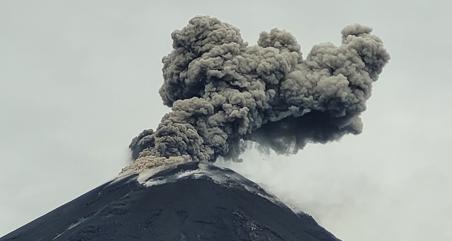
Emission/Ash Column:
The surveillance camera system observed several gas and ash emissions ranging from 100 to 1,000 meters above the crater level, in southwest, west-northwest, and west-southwest directions. In connection with this activity, the Washington-based VAAC agency issued three emission reports, with columns reaching heights of more than 1,000 meters above the crater level, in west and southwest directions.
Other monitoring parameters:
The MIROVA-MODIS satellite system recorded 1 thermal anomaly, and the FIRMS satellite system recorded 6 thermal anomalies over the past 24 hours.
Observation:
Since yesterday afternoon, several episodes of incandescent material falling on the volcano’s flanks have been observed, between 350 and 900 meters below the crater. Furthermore, the volcano remained partially to completely clear for most of the time.
Alert Level – SGR: Orange
Source et photo : IGEPN
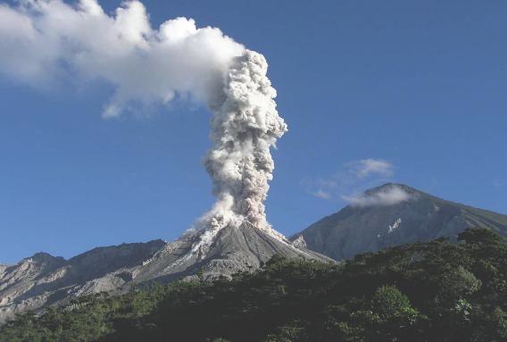
Guatemala , Santiaguito :
Weather Conditions: Clear.
Wind: Southwest.
Precipitation: 0.0 mm.
Activity:
Outgassing is observed recurrently above the Caliente dome, with increasing pulses forming a gas column up to 500 meters high. Weak to moderate explosions are recorded, which can cause incandescence and columns of gas and ash up to 3,500 meters above sea level (10,498 feet), as well as avalanches in south, southwest, and west directions. Ash could spread 15 to 40 km to the east and northeast, potentially causing fine ashfall on farms and communities near the volcano, such as Zunil and Cantel. The Santiaguito volcano remains very active. Therefore, the presence of moderate to strong block and ash flows, as well as possible pyroclastic flows over long distances and in different directions, cannot be excluded. It is therefore advisable to follow the recommendations of special bulletin BESAN-002-2025.
Precautions regarding air traffic are recommended in the area of the Fuego and Santiaguito volcanoes due to the possible presence of ash within a radius of 15 to 40 kilometers from the volcano. For the Santiaguito volcano, the dispersal of ash towards the northeast and east, at heights of 2,500 to 3,500 meters above sea level (8,202 to 11,482 feet), should be considered. Consider the variability of wind direction at different altitudes and the fact that accelerated winds can disperse ash over even greater distances. It is recommended to pay attention to the ash dispersal maps generated by INSIVUMEH.
Source : Insivumeh .
Photo : La Hora