Italy / Sicily , Etna :
WEEKLY BULLETIN, from February 02, 2025 to February 09, 2025. (issue date February 11, 2025)
SUMMARY OF ACTIVITY STATUS
In light of monitoring data, it is highlighted:
1) VOLCANOLOGICAL OBSERVATIONS: Effusive activity from an eruptive fissure at the base of the Bocca Nuova crater, modest and episodic Strombolian activity at the Southeast crater and degassing at the Bocca Nuova, Voragine and Northeast crater.
2) SEISMOLOGY: Absence of seismic activity due to fracturing with Ml>=2.0. Average amplitude of volcanic tremor at the average level.
3) INFRASOUND: Low infrasound activity with sources located in the Southeast Crater (SEC) area.
4) GROUND DEFORMATIONS: During the last week, ground deformation monitoring networks did not record significant variations. Small inclinometric variations, (tenths of a microradian) were detected at the summit station of Cratere del Piano (CDP) in the afternoon of February 8 at the beginning of the summit effusive activity.
5) GEOCHEMISTRY: SO2 flux at medium level
Soil CO2 flux (EtnaGas Network): medium-high values.
The partial pressure of dissolved CO2 in the aquifer (Ponteferro) shows values in seasonal variability.
Helium isotope ratio in peripheral sites: latest updated data on medium-high values (31/01/2025)
6) SATELLITE OBSERVATIONS: The thermal activity observed by satellite in the summit area was generally low level with high to very high values corresponding to the effusive activity that started on 8 February 2025.
VOLCANOLOGICAL OBSERVATIONS
During the observation period, the monitoring of the volcanic activity of Etna was carried out through the analysis of images from the surveillance camera network of the National Institute of Geophysics and Volcanology, Osservatorio Etneo (INGV-OE) and through inspections carried out in the summit area by INGV staff on 8 and 9 February.
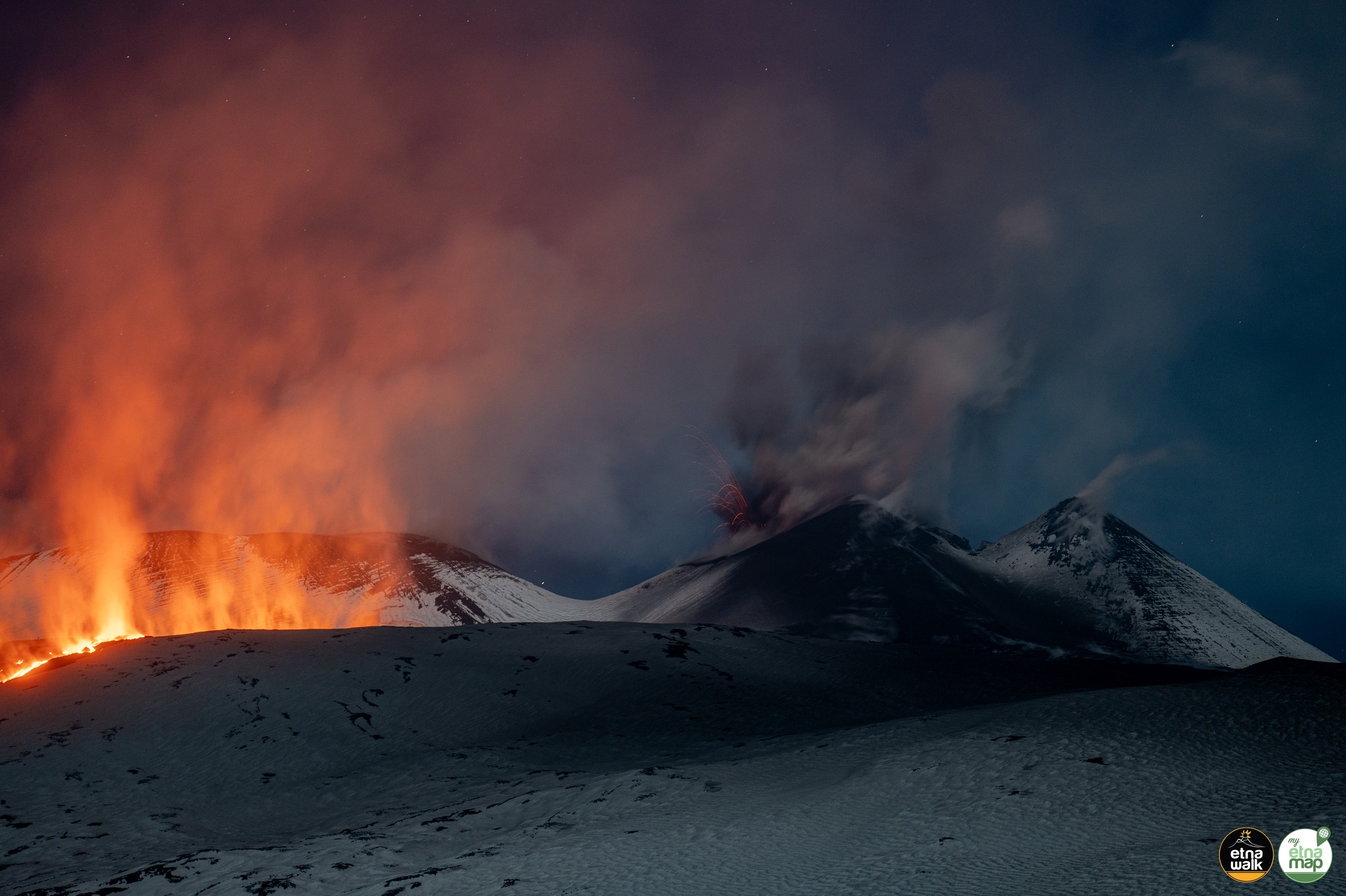
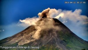
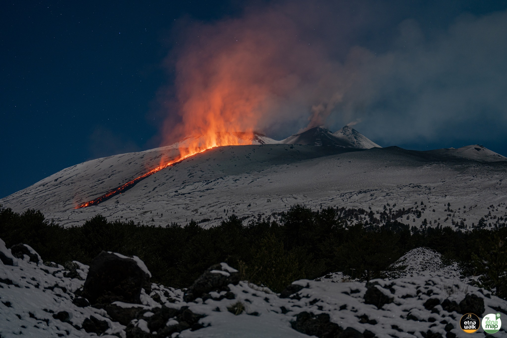
After a period of volcanic activity characterized by variable rate degassing in all the craters, about 3 months after the last active lava fountain on November 10, 2024, on February 6, Etna began a new eruptive phase of explosive and effusive type. In detail, the explosive activity begins on February 6 with a modest and episodic Strombolian activity produced by a vent located in the western sector of the southeast crater (CSE). On February 8, this activity was followed by the beginning of an effusive phase fed by an eruptive fissure that opened at the base of the Bocca Nuova crater at an altitude of about 3050 meters above sea level, with a lava flow that advanced in a southerly direction towards Mount Frumento Supino. Given the unfavourable weather conditions, the first observations via INGV surveillance cameras took place at 17:35 UTC, so it cannot be excluded that the lava emission started a few hours earlier. According to observations made by INGV staff in the field on 8 February, the lava flow appeared to be well fed and Strombolian activity persisted at the CSE.
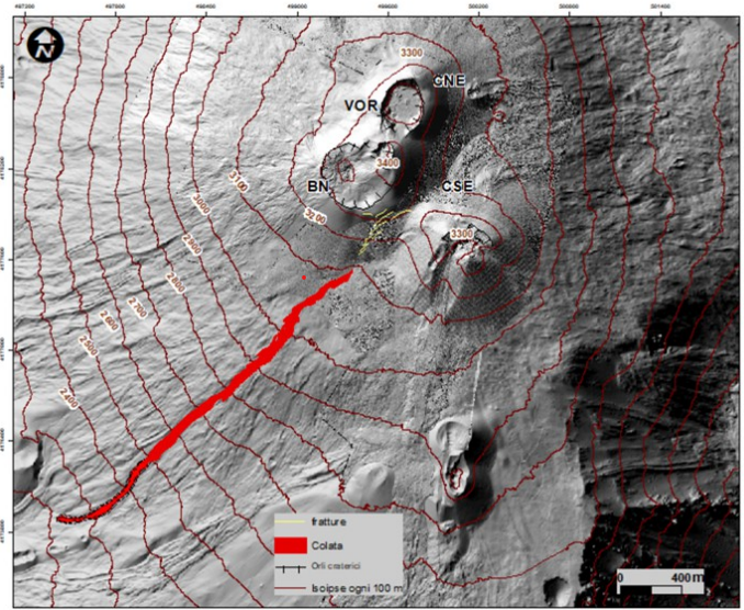
Map of the summit area of Etna, superimposed on the shaded relief of the terrain obtained by processing the images acquired by drone on September 12, 2024, for the BN, VOR and CNE craters, and on July 31, 2024 for the CSE. CSE = Southeast Crater, CNE = Northeast Crater VOR = Doline BN = New Mouth. The flow mapping is updated as of February 11 (the dotted boundary is uncertain).
The map of the summit area of Etna with the lava field mapped using Skysat satellite images of February 9, 10 and 11, 2025 at 08:00 UTC and Sentinel 2 of February 10, 2025 10:00 UTC. From the data processing, it is clear that on 11 February the lava flow reached a length of 2600 m with the most advanced front reaching an altitude of about 2200 m. The area covered by the lava flow is about 1.3 × 10⁵ m2 and the volume of the flow is about 2.5 × 10⁵ m3 (uncertainty 40%).
Source : INGV
Photos : Giuseppe Distefano / Marco Restivo / Etna Walk , INGV
Hawaii , Kilauea :
HAWAIIAN VOLCANO OBSERVATORY STATUS REPORT / U.S. Geological Survey
Tuesday, February 11, 2025, 10:58 AM HST (Tuesday, February 11, 2025, 20:58 UTC)
19°25’16 » N 155°17’13 » W,
Summit Elevation 4091 ft (1247 m)
Current Volcano Alert Level: WATCH
Current Aviation Color Code: ORANGE
Activity Summary:
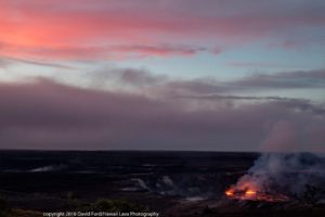
Episode 9 of the ongoing Halemaʻumaʻu eruption began this morning, February 11 at 10:16 a.m. HST with lava fountains producing a lava flow on Halemaʻumaʻu crater floor.

Episode 9 was preceded by small, sporadic spatter fountains that began early yesterday morning and increased in intensity overnight. Fountains from the north vent are estimated to be roughly 330 feet (100 meters) high at 10:45 a.m. and covering about a quarter of the Halemaʻumaʻu crater floor. Slow effusion of lava at the south vent began at approximately 10:50 a.m.
Inflationary tilt at the summit recovered about 9 microradians since the previous eruptive episode. Seismic tremor began increasing and tilt at UWD switched from inflation to deflation at about 10:25 a.m. HST.
Each episode of Halemaʻumaʻu lava fountaining since December 23, 2024, has continued for 13 hours to 8 days and episodes have been separated by pauses in eruptive activity lasting a less than 24 hours to 12 days.
No changes have been detected in the East Rift Zone or Southwest Rift Zone. HVO continues to closely monitor Kīlauea and will issue an eruption update tomorrow morning unless there are significant changes before then.
Kīlauea Volcano Alert Level/Aviation Color Code remain at WATCH/ORANGE. All current and recent activity is within Hawaiʻi Volcanoes National Park.
Source et photo : HVO
Italy , Stromboli :
WEEKLY BULLETIN, from February 02, 2025 to February 09, 2025. (issue date February 11, 2025)
SUMMARY OF ACTIVITY STATUS
In light of the monitoring data, it is highlighted:
1) VOLCANOLOGICAL OBSERVATIONS: During this period, intense eruptive activity was observed with splashes coming from the northern area of the crater and the emission of a modest lava flow. The total hourly frequency varied between average values (8-14 events/h). The intensity of the explosions was low and average in the areas of the North and Center-South craters.
2) SEISMOLOGY: The monitored seismic parameters do not show significant variations.
3) GROUND DEFORMATIONS: Ground deformation monitoring networks have not shown significant variations over the past week
4) GEOCHEMISTRY: SO2 flux at an average level.
Soil CO2 flux from the Pizzo area (STR02): it is at very high values
CO2/SO2 ratio in the plume (Stromboli Plume Network): high values
Helium isotope ratio (R/Ra) dissolved in the thermal aquifer: last updated on 31 January 2025, high values.
Soil CO2 flux in the San Bartolo area at average values.
Soil CO2 flux in the Scari area at average values.
5) SATELLITE OBSERVATIONS: The thermal activity observed by satellite in the summit area was generally low level with some isolated thermal anomalies of moderate level.
VOLCANOLOGICAL OBSERVATIONS
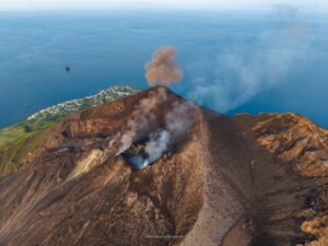
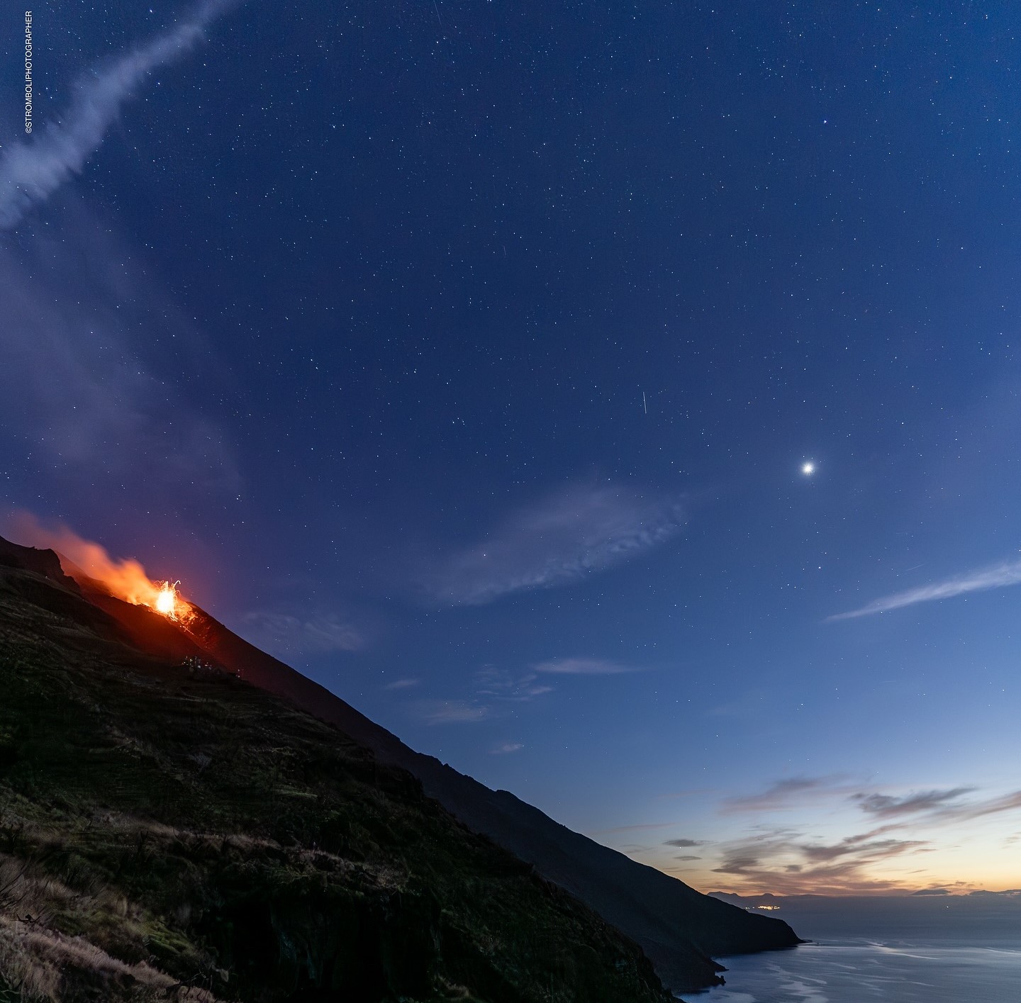
During the observation period, the eruptive activity of Stromboli was characterized by the analysis of the images recorded by the INGV-OE surveillance cameras located at an altitude of 190 m (SCT-SCV) and at Punta dei Corvi (SPCT). The explosive activity was produced mainly by 4 (four) eruptive vents located in the North crater area and by 2 (two) vents located in the Centre-South area. Due to unfavorable weather conditions, the visibility of the crater terrace on 3 and 8 February was insufficient for a correct description of the eruptive activity.
In the North (N) crater area, four active vents were observed that produced explosive activity of low intensity (less than 80 m in height) and sometimes of medium intensity (less than 150 m in height). In addition, at the vents of the North Crater area, spattering activity was observed, sometimes intense during the day of February 6 in the N2 sector and during the day of February 7 in the N1 sector. The emitted products consisted mainly of coarse materials (bombs and lapilli). The average explosion frequency varied between 6 and 11 events/h. In the South-Central (CS) area, explosive activity was produced by at least two vents, the explosions were of low and medium intensity and consisted mainly of coarse materials (lapilli and bombs). The average explosion frequency varied between 1 and 6 events/h.
Lava overflow of February 6.
On 6 February, at 06:07 UTC, an intense spattering activity started from the mouth facing the Sciara del Fuoco in sector N2, which intensified within a few minutes, producing an accumulation of lava fragments. Subsequently, a modest lava flow was observed, extending below the outlet for a few tens of meters.
At 11 UTC, the flow appeared to be cooling and poorly fed.
Source : INGV
Photo : Stromboli stati d’animo / Sebastiano Cannavo
Indonesia , Dukono :
An eruption of Mount Dukono occurred on Wednesday, 12 February 2025 at 08:08 WIT with an observed ash column height of ±800 m above the peak (±1887 m above sea level). The ash column was observed to be white to grey in colour with a thick intensity, oriented towards the east. At the time of writing, the eruption was still ongoing.

Seismicity observation:
249 eruption earthquakes with an amplitude of 6 to 34 mm and a duration of 35.19 to 190.76 seconds.
4 Distant tectonic earthquakes with an amplitude of 14-20 mm, and an earthquake duration of 62.26-72.96 seconds.
1 Continuous Tremor earthquake with an amplitude of 1-6 mm, dominant value 2 mm.
Recommendation
(1) People in the vicinity of Mount Dukono and visitors/tourists should not engage in activities, climb or approach the Malupang Warirang Crater within a radius of 4 km.
(2) Since volcanic ash eruptions occur periodically and the distribution of ash follows the direction and speed of the wind, so the area where the ash lands is not constant, residents around Mount Dukono are advised to always carry masks/nose and mouth covers to use when needed to avoid the threat of volcanic ash to the respiratory system.
Source et photo : Magma Indonésie .
Colombia , Puracé – Los Coconucos volcanic chain :
Popayán, February 11, 2025, 3:30 p.m. .
Following the monitoring of the activity of the Puracé volcano – Los Coconucos volcanic chain, the Colombian Geological Survey (SGC), an entity attached to the Ministry of Mines and Energy, reports that:
During the week of February 4 to 10, 2025, seismic activity showed stable behavior, without significant variations in the number of events or in their released energy. The earthquakes associated with rock fracturing were located mainly under the Puracé volcano and, to a lesser extent, under the crater of the Piocollo volcano, in a depth range between 1 and 3 km and a maximum recorded magnitude of 1.1. The events related to fluid dynamics occurred at depths of less than 1 km, mainly under the crater of the Puracé volcano.
Calculated values of sulfur dioxide (SO2) flux remain above reference levels, while the slow deformation process between the volcanic buildings of Puracé, Piocollo and Curiquinga is still ongoing.
In the images captured by the visible and infrared spectrum webcams, degassing processes were observed in the lateral fumarole of the Puracé volcano crater and in the system of
fissures and cavities that extend between the Curiquinga and Piocollo volcanoes.
In the yellow alert state, phenomena such as sporadic ash emissions (minor eruptions) may occur, the magnitude and effects of which are limited, and the dispersion of ash depends on the wind direction, the presence of some incandescence, small explosions in the crater, low-energy thermal anomalies, noise, felt earthquakes, odors, precipitation of elemental sulfur near the crater and in hot springs and fumaroles, degassing in areas other than the crater. The formation of fissures and the appearance of minor mudflows, among others, are also observed.
Based on the above, the SGC recommends closely monitoring the evolution of volcanic activity through weekly bulletins and other information published on official channels, as well as following the instructions of local and departmental authorities and the National Disaster Risk Management Unit (UNGRD). The alert status for volcanic activity remains at yellow alert status: active volcano with changes in the behavior of the base level of monitored parameters and other manifestations.
Source : SGC
Photo : Cric-colombia .org ( 01/2025)