February 04 , 2025.
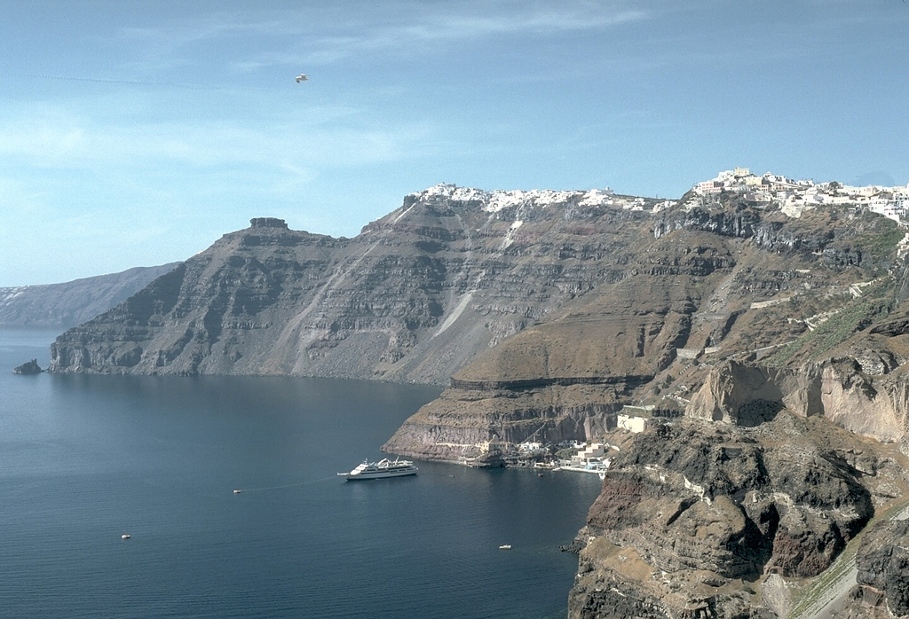
Greece , Santorini :
The seismic crisis, which has been going on for over a week, has reached a new peak on the Greek volcanic island of Santorini. Numerous earthquakes of higher magnitude have occurred in the last 24 hours, causing minor damage and numerous landslides on the island.
Greek authorities have detected about 600 earthquakes since the seismic crisis began on January 24. The actual number of earthquakes is probably already in the hundreds of thousands. The seismic swarm, originating in the northeast of Santorini, reached extreme proportions on Monday. Two earthquakes reached a magnitude of 5. Below magnitude 4, a complete assessment is no longer possible due to the large number of earthquakes.
The earthquakes are occurring along a fault zone that extends northeast of Santorini. In 1956, this fault zone was the starting point of a 7.6 magnitude earthquake that caused severe damage to the Dodecanese islands. The tsunami that was triggered reached wave heights of over 20 meters on the island of Amorgos.
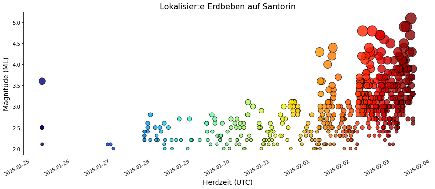
There are currently many speculations and conflicting reports about the likelihood of such an earthquake. Efthymios Lekkas, professor of civil protection and tectonics at the University of Athens, has ruled out in interviews with Greek media that the current seismic swarm will lead to an earthquake of such magnitude. Since little stress has accumulated along the fault since 1956, an earthquake of magnitude greater than 6 is not possible.
Akis Tselentis, professor of seismology at the University of Athens, criticized Lekkas’ statement and the authorities’ general public relations work on the subject in a social media post and indirectly accused him of spreading false statements in the interest of the tourism industry. Due to its dimensions, Tselentis did not rule out the possibility of a severe earthquake and called on locals and tourists to prepare for the possible occurrence of such an earthquake and subsequent tsunamis. He pointed out problems with the structure of many houses in Santorini. He also did not consider possible interaction with possible volcanic activity to be impossible.
Summary:
The situation in Santorini is frightening for locals and tourists and is further reinforced by the usual dramatization in the media. Inconsistent and clumsy crisis communication by the Greek authorities reinforces the effect. It is completely unclear how the situation will develop. However, the risk that the seismic swarm will lead to a potentially catastrophic earthquake with a tsunami is not particularly high in real terms. An exact assessment is not possible. However, due to the high risk potential, precautionary measures are urgently needed. Also to better capture possible subsequent volcanic risks. But the greatest danger certainly comes from possible large earthquakes, with a magnitude of around 6.5, and tsunamis.
Source : Erdbebennews , de.
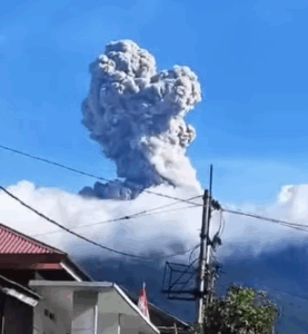
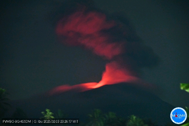
Indonesia , Ibu :
An eruption of Mount Ibu occurred on Monday, 3 February 2025, at 23:25 WIT with an observed ash column height of ± 1500 m above the peak (± 2825 m above sea level). The ash column was observed to be grey in colour with a thick intensity, oriented towards the East and South-East. This eruption was recorded on a seismograph with a maximum amplitude of 28 mm and a duration of 153 seconds.
The eruption of Ibu continues. Explosions at 22:07, 16:04, 06:37 etc.
VOLCANO OBSERVATORY NOTICE FOR AVIATION – VONA
Issued : February 03 , 2025
Volcano : Ibu (268030)
Current Aviation Colour Code : ORANGE
Previous Aviation Colour Code : orange
Source : Ibu Volcano Observatory
Notice Number : 2025IBU250
Volcano Location : N 01 deg 29 min 17 sec E 127 deg 37 min 48 sec
Area : North Maluku, Indonesia
Summit Elevation : 4240 FT (1325 M)
Volcanic Activity Summary :
Eruption with volcanic ash cloud at 14h25 UTC (23h25 local).
Volcanic Cloud Height :
Best estimate of ash-cloud top is around 9040 FT (2825 M) above sea level or 4800 FT (1500 M) above summit. May be higher than what can be observed clearly. Source of height data: ground observer.
Other Volcanic Cloud Information :
Ash cloud moving from east to southeast. Volcanic ash is observed to be gray. The intensity of volcanic ash is observed to be thick.
Remarks :
Eruption recorded on seismogram with maximum amplitude 28 mm and maximum duration 153 second.
Source et photo : Magma Indonésie .
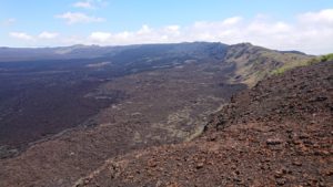
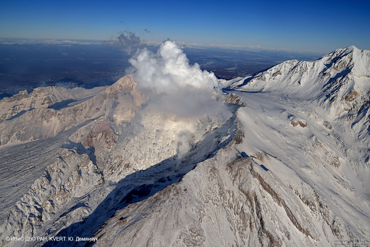
Kamchatka , Sheveluch :
VOLCANO OBSERVATORY NOTICE FOR AVIATION (VONA)
Issued: February 04 , 2025
Volcano: Sheveluch (CAVW #300270)
Current aviation colour code: ORANGE
Previous aviation colour code: orange
Source: KVERT
Notice Number: 2025-13
Volcano Location: N 56 deg 38 min E 161 deg 18 min
Area: Kamchatka, Russia
Summit Elevation: 3283 m (10768.24 ft), the dome elevation ~2500 m (8200 ft)
Volcanic Activity Summary:
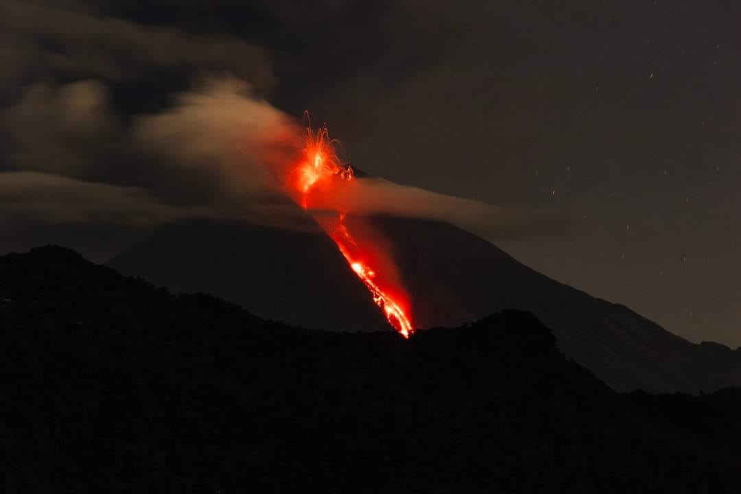
The extrusive-effusive eruption of the Young Sheveluch volcano and the extrusive eruption of the 300 years RAS lava dome continue. The growth of the lava domes is accompanied by powerful gas-steam activity. According to satellite data by KVERT a large gas-steam plume with some amount of ash is extending for 20 km to the east of the volcano.
An extrusive-effusive eruption of the Sheveluch volcano continues. The danger of ash explosions up to 10 km (32,800 ft) a.s.l. remains. Ongoing activity could affect international and low-flying aircraft.
Volcanic cloud height:
3500 m (11480 ft) AMSL Time and method of ash plume/cloud height determination: 20250204/0145Z – Video data
Other volcanic cloud information:
Distance of ash plume/cloud of the volcano: 20 km (12 mi)
Direction of drift of ash plume/cloud of the volcano: E / azimuth 93 deg
Time and method of ash plume/cloud determination: 20250204/0046Z – NOAA-20 15m16
Source : Kvert
Photo : Yu. Demyanchuk. IVS FEB RAS, KVERT.
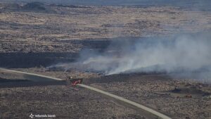
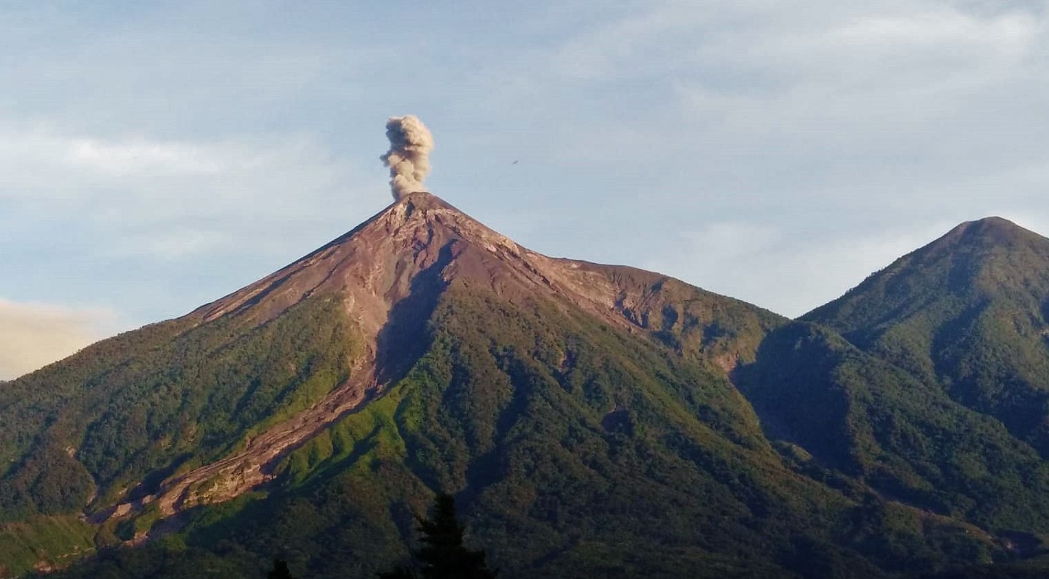
Guatemala , Fuego :
Weather conditions: Clear
Wind: South-East
Precipitation: 0.0 mm.
Activity:
Currently, no explosions have been recorded. Periods of degassing are observed, generating low columns of steam and magmatic gases, which reach between 100 and 150 meters above the crater level and move according to the wind direction. No incandescent pulses have been observed or ash falls reported in nearby communities, and no rumbling, shock waves or noise have been recorded. The wind can lift fine sediments accumulated in the ravines, forming an ash curtain on the southwest flank of the volcano. Regarding explosive activity, it is recommended to follow the indications described in the special bulletin BEFGO-001-2025.
Source : Insivumeh
Photo : Conred
Ecuador , Sangay :
DAILY REPORT ON THE STATE OF THE SANGAY VOLCANO, Monday, February 03, 2025.
Information Geophysical Institute – EPN.
Surface activity level: Moderate, Surface trend: No change
Internal activity level: Moderate, Internal trend: No change
Seismicity: From February 02, 2025, 11:00 a.m. to February 03, 2025, 11:00 a.m.:
Seismicity:
Below is the count of seismic events recorded at the reference station
Explosion (EXP): 83
Rainfall/Lahars:
The presence of rain in the volcano area or surroundings, which could generate mud and debris flows, was not recorded by the surveillance cameras. **In the event of heavy rain, it could remobilize the accumulated materials, generating mud and debris flows that would descend the sides of the volcano and flow into adjacent rivers.
Emission/Ash Column:
Since yesterday, the surveillance camera system has been recording the emission of gas and ash at a height of 300 meters above the crater level. On the other hand, the VAAC agency in Washington has not issued any report for Sangay in the last 24 hours.
Other monitoring parameters:
The FIRMS and MIROVA-VIIRS satellite systems recorded 25 thermal anomalies and 2 moderate thermal anomalies, respectively, in the last 24 hours.
Observation:
During the last 24 hours, some episodes of incandescence were observed at the crater level thanks to the monitoring of surveillance cameras. The volcano remained partially or completely cloudy.
Niveau d’alerte : jaune
Source : IGEPN
Photo : Luis Lema via volcan Sangay FB , 30/03/2024