October 11 , 2024.
Indonesia , Ibu :
An eruption of Mount Ibu occurred on Friday, 11 October 2024 at 09:32 WIT with the height of the ash column observed at ±1000 m above the summit (±2325 m above sea level). The ash column was observed to be grey with a thick intensity, oriented towards the West. This eruption was recorded on a seismograph with a maximum amplitude of 28 mm and a duration of 71 seconds.
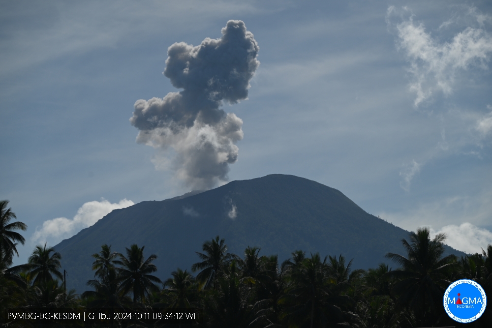
VOLCANO OBSERVATORY NOTICE FOR AVIATION – VONA
Issued : October 11 , 2024
Volcano : Ibu (268030)
Current Aviation Colour Code : ORANGE
Previous Aviation Colour Code : orange
Source : Ibu Volcano Observatory
Notice Number : 2024IBU942
Volcano Location : N 01 deg 29 min 17 sec E 127 deg 37 min 48 sec
Area : North Maluku, Indonesia
Summit Elevation : 4240 FT (1325 M)
Volcanic Activity Summary :
Eruption with volcanic ash cloud at 00h32 UTC (09h32 local).
Volcanic Cloud Height :
Best estimate of ash-cloud top is around 7440 FT (2325 M) above sea level or 3200 FT (1000 M) above summit. May be higher than what can be observed clearly. Source of height data: ground observer.
Other Volcanic Cloud Information :
Ash cloud moving to west. Volcanic ash is observed to be gray. The intensity of volcanic ash is observed to be thick.
Remarks :
Eruption recorded on seismogram with maximum amplitude 28 mm and maximum duration 71 second.
Source et photo : Magma Indonésie
Kamchatka , Sheveluch :
VOLCANO OBSERVATORY NOTICE FOR AVIATION (VONA)
Issued: October 11 , 2024
Volcano: Sheveluch (CAVW #300270)
Current aviation colour code: ORANGE
Previous aviation colour code: orange
Source: KVERT
Notice Number: 2024-84
Volcano Location: N 56 deg 38 min E 161 deg 18 min
Area: Kamchatka, Russia
Summit Elevation: 3283 m (10768.24 ft), the dome elevation ~2500 m (8200 ft)
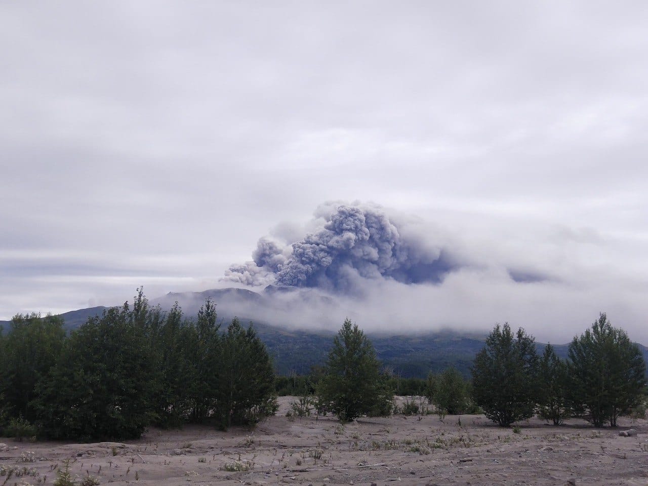
Volcanic Activity Summary:
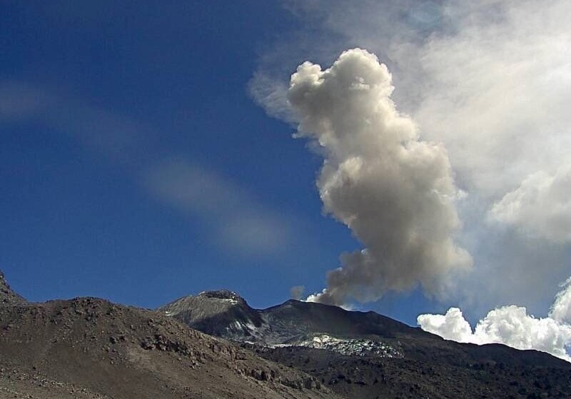
Video and satellite data by KVERT shows a strong wind lifts ash from the southern slopes of Sheveluch volcano, and a plume of resuspended ash is extending about 75 km to the east-south-east of the volcano.
An extrusive-effusive eruption of the Sheveluch volcano continues. The danger of ash explosions up to 10 km (32,800 ft) a.s.l. remains. Ongoing activity could affect international and low-flying aircraft.
Volcanic cloud height:
2000-2500 m (6560-8200 ft) AMSL Time and method of ash plume/cloud height determination: 20241010/2030Z – Himawari-9 14m15
Other volcanic cloud information:
Distance of ash plume/cloud of the volcano: 75 km (47 mi)
Direction of drift of ash plume/cloud of the volcano: ESE / azimuth 116 deg
Time and method of ash plume/cloud determination: 20241010/2030Z – Himawari-9 14m15
Source : Kvert
Photo : Frolov Viktor ( 08/2024)
Colombia , Nevado del Ruiz :
Manizales, October 8, 2024, 8:30 p.m.
From the monitoring of the activity of the Nevado del Ruiz volcano, the Colombian Geological Survey (SGC), an entity attached to the Ministry of Mines and Energy, reports that:
During the week of October 1 to 7, 2024, the volcano continued with unstable behavior. Compared to the previous week, the main variations in the monitored parameters were:
– Seismicity related to the activity of fluids inside volcanic conduits showed a decrease in the number of earthquakes recorded and in the seismic energy released by seismic signals related to pulsatile ash emissions, and an increase in long-period signals. The energy levels of the signals ranged from low to moderate for signals associated with pulsatile ash emissions and from low to very low for long-period events. Through the cameras used to monitor the volcano, and from the reports received from the officials of the Los Nevados National Natural Park and the staff of the Colombian Geological Survey during the field work, it was possible to confirm some ash emissions. Using FLIR (thermographic) cameras, several changes in the temperature of the emitted material were detected. Both phenomena mentioned were associated with some of these seismic events.

– Seismic activity associated with rock fracturing within the volcanic edifice increased in the number of recorded earthquakes and in the seismic energy released. The earthquakes were located mainly in the Arenas crater and on the northeast, east and south-southwest flanks, at distances less than 5 km from the crater. The depths of the events varied between less than 1 km and 7 km from the summit of the volcano. The strongest magnitude of the week was 1.3, corresponding to two earthquakes recorded on October 6 at 14:54 and 17:20, located 3 km south-southwest of the Arenas crater, at depths of 4.2 km and 3.8 km respectively. From October 1 to 4, seismicity was recorded related to the activity of the lava dome (protuberance or mound) located at the bottom of the crater with low energy levels.
– On the volcano, the emission of water vapor and gases into the atmosphere from the Arenas crater continued. The estimation of sulfur dioxide (SO2) degassing rates was affected by the wind direction, which on several occasions did not favor the location of the measuring stations. In general, these were variable and similar to the previous week.
– The maximum height of the vertical gas column was 1800 m (measured above the volcanic summit), on October 7, and in dispersion it reached 1400 m on the 1st and 6th. The direction of dispersion of the column was variable and on several occasions showed a greater tendency towards the Northwest, North-Northwest and West-Northwest of the volcano. From the Bruma and Valle de las Tumbas sectors (in the PNNN area) and from the city of Manizales (Caldas department), several reports of ashfall have been received.
– By monitoring thermal anomalies at the bottom of the Arenas crater, from satellite monitoring platforms, some reports of low to moderate energy level anomalies have been obtained.
Source et photo : SGC
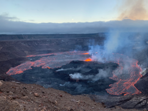
Hawaii , Kilauea :
Thursday, October 10, 2024, 8:51 AM HST (Thursday, October 10, 2024, 18:51 UTC)
19°25’16 » N 155°17’13 » W,
Summit Elevation 4091 ft (1247 m)
Current Volcano Alert Level: ADVISORY
Current Aviation Color Code: YELLOW
Activity Summary:
Kīlauea volcano is not erupting. Weak steaming continues on the inactive September 15–20 lava flow field within Nāpau Crater on the middle East Rift Zone. No changes have been detected in the lower East Rift Zone or Southwest Rift Zone. A wildfire that began on September 15 to the south of Nāpau Crater continues smoldering at this time, with wildfire smoke and incandescence intermittently visible in PWcam and S2cam imagery.
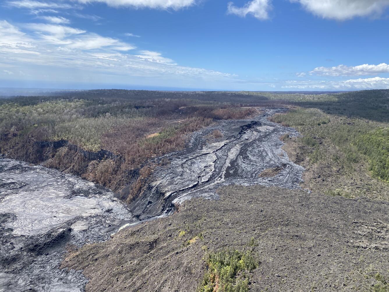
This overflight image taken on Monday, October 7, shows the inactive lava flows from the western rim of Nāpau Crater (center) and on the crater floor (lower left).
Summit Observations:
There were 3 earthquakes detected beneath the Kīlauea summit region over the past 24 hours. The summit tiltmeters at Uēkahuna and Sandhill show no significant inflation or deflation over the past few days. The most recent measurement of the sulfur dioxide (SO2) emission rate at the summit was approximately 60 tonnes per day on September 17, 2024.
Rift Zone Observations:
The middle East Rift Zone (MERZ) eruption near Nāpau Crater stopped around 10 a.m. HST on the morning of September 20. Only minor steaming from the eruption site has been seen in webcam imagery since that time. No SO2 from the eruption site was detected on Monday, September 23 during measurements on Chain of Craters Road, indicating that MERZ SO2 emissions are negligible.
Shallow earthquake counts are steady over the past day with 13 earthquakes in the MERZ and upper East Rift Zone, with tremor no longer being recorded on seismometers near the eruption site. Tiltmeters in the MERZ show modest deflation and GPS instruments show low rates of deformation.
All recent activity was confined to the middle East Rift Zone between Makaopuhi Crater and Puʻuʻōʻō and there are no indications of any changes downrift in the lower East Rift Zone.
Source : HVO
Photo : USGS / L. DeSmither.
Peru , Sabancaya :
Analysis period: from September 30, 2024 to October 06, 2024, Arequipa, October 09, 2024
Alert level: ORANGE
The Geophysical Institute of Peru (IGP) reports that the eruptive activity of the Sabancaya volcano continues. During this period, an average of 19 daily explosions have been recorded, with columns of ash and gas up to 1,300 m above sea level above the summit of the volcano. Therefore, the volcanic alert level remains at ORANGE
The IGP has recorded and analyzed the occurrence of 248 earthquakes of volcanic origin, associated with the circulation of magmatic fluids inside the Sabancaya volcano, as well as earthquakes related to rock fracturing. An average of 19 explosions have been recorded daily.
Columns of ash and gas have been observed up to 1300 m above sea level above the summit of the volcano. The predominant direction of these emissions has been towards the South-West and West sectors of the volcano over a distance of less than 10 KM.
A slight inflation process continues to be recorded in the North sector (around the Hualca Hualca volcano).
Satellite recordings have identified the presence of 22 thermal anomalies, with a maximum value of 5 MW, associated with the presence of a body of lava on the surface of the volcano’s crater.
Moderate emissions (532 tons/day) of sulfur dioxide (SO2) have been observed
RECOMMENDATIONS
• Maintain the orange volcanic alert level.
• Do not approach within a radius of less than 12 km of the crater.
Source : Cenvul
Photo : Ingemmet ( 2021)