October 03 , 2024.
Italy , Stromboli :
Statement on Stromboli activity, 02 October 2024 11:04 (09:04 UTC)
The National Institute of Geophysics and Volcanology, Osservatorio Etneo, communicates that according to the analysis of surveillance camera images and observations by INGV personnel in the field, it is reported that the effusive activity of the lava overflow from the North Crater area reported in the press release of 1 October at 03:14 UTC gradually dried up in the early hours of 2 October. The effusive activity was characterized by a high initial emission rate that produced a lava flow that reached the coastline on the morning of 1 October.
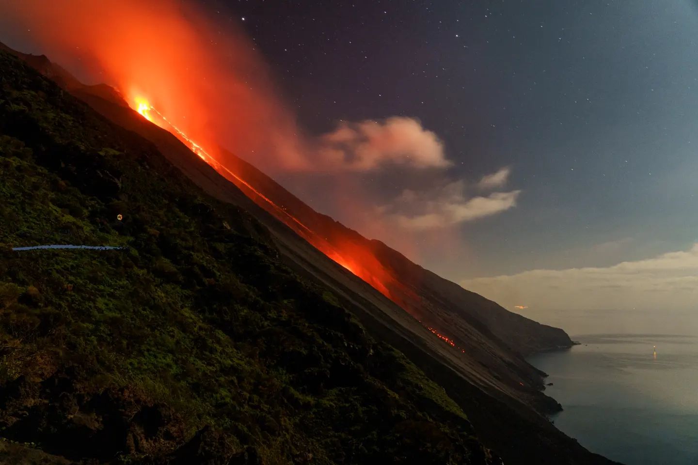
However, the persistence of the front at the base of the Sciara was temporary and by early afternoon the lava front was retreating.
At present, ordinary explosive activity is at a low level and low projection activity persists in the northern area. Occasional landslides are also observed along the Sciara del Fuoco.
From a seismic point of view, the average amplitude of the tremr remains at the average level.
The inclinometric and GNSS stations monitoring ground deformations do not record significant variations.
Further updates will be communicated shortly.
Source : INGV
Photo : Stromboli stati d’animo / Sebastiano Cannavo. ( 01/2023)
Indonesia , Ibu :
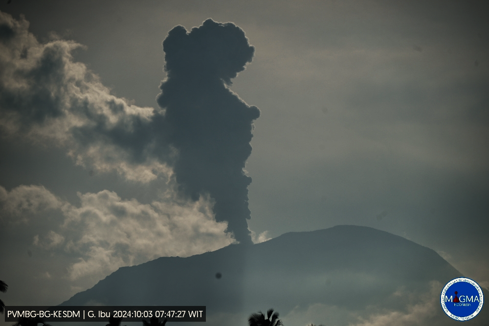
An eruption of Mount Ibu occurred on Thursday, 3 October 2024 at 07:46 WIT with the height of the ash column observed at ± 800 m above the summit (± 2,125 m above sea level). The ash column was observed to be grey in colour with a thick intensity, oriented towards the northwest. This eruption was recorded on a seismograph with a maximum amplitude of 28 mm and a duration of 52 seconds.
VOLCANO OBSERVATORY NOTICE FOR AVIATION – VONA
Issued : October 03 , 2024 .
Volcano : Ibu (268030)
Current Aviation Colour Code : ORANGE
Previous Aviation Colour Code : orange
Source : Ibu Volcano Observatory
Notice Number : 2024IBU935
Volcano Location : N 01 deg 29 min 17 sec E 127 deg 37 min 48 sec
Area : North Maluku, Indonesia
Summit Elevation : 4240 FT (1325 M)
Volcanic Activity Summary :
Eruption with volcanic ash cloud at 22h46 UTC (07h46 local).
Volcanic Cloud Height :
Best estimate of ash-cloud top is around 6800 FT (2125 M) above sea level or 2560 FT (800 M) above summit. May be higher than what can be observed clearly. Source of height data: ground observer.
Other Volcanic Cloud Information :
Ash cloud moving to northwest. Volcanic ash is observed to be gray. The intensity of volcanic ash is observed to be thick.
Remarks :
Eruption recorded on seismogram with maximum amplitude 28 mm and maximum duration 52 second.
Source et photo : Magma Indonésie .
Colombia , Chiles / Cerro Negro :
San Juan de Pasto, October 1, 2024, 5:00 p.m. .
From the monitoring of the activity of the Chiles and Cerro Negro volcanoes, the Colombian Geological Survey (SGC), an entity attached to the Ministry of Mines and Energy, reports that:
In the week of September 24 to 30, 2024, the activity of these volcanoes showed variations in their records, which are part of a stable behavior. Compared to the previous week, the main variations in the monitored parameters were:
• A significant increase was recorded both in the frequency of earthquakes and in the levels of energy released.
• The seismicity associated with the fracturing of rocks was predominant, both in terms of occurrence and energy released.
• The recording of seismicity related to the movement of fluids inside volcanic conduits was maintained, which show a very low frequency.
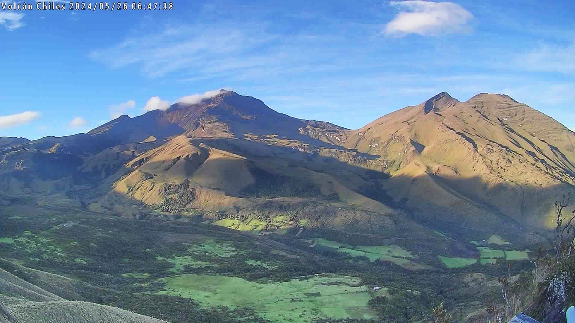
• Fracture earthquakes were located in three main sectors. The first was located at the summit and collapse zone of Chiles Volcano, at distances between 0 and 2 km, with depths between 2 and 4 km from the summit (4,700 m) and a maximum magnitude of 2.4. The second sector, south of Chiles Volcano, at distances between 1 and 3 km, with depths between 3 km and 4 km and a maximum magnitude of 1.6. The third sector was located southeast of the Chiles summit, at distances between 7 and 10 km, with depths between 8 and 10 km and a maximum magnitude of 1.6. No felt earthquakes were reported.
• Field sensors and remote satellite sensors recording deformation continued to show changes associated with an inflationary process in the volcanic area.
Based on the above, the SGC recommends to closely monitor the developments through weekly bulletins and other information published through our official channels, as well as the instructions of local and departmental authorities and the National Disaster Risk Management Unit (UNGRD).
Volcanic activity remains in yellow alert status: active volcano with changes in the behavior of the base level of monitored parameters and other manifestations.
Source et photo : SGC
La Réunion , Piton de la Fournaise :
Monthly Bulletin . Paris Institute of Earth Physics , Piton de la Fournaise Volcanological Observatory. September 2024 .
Seismicity
In September 2024, the OVPF-IPGP recorded in the Piton de la Fournaise massif in total:
• 30 superficial volcano-tectonic earthquakes (0 to 2.5 km above sea level) under the summit craters;
• 6 deep earthquakes (below sea level);
• 30 long-period earthquakes;
• 264 landslides.
The month of September 2024 was marked by low seismicity under the Piton de la Fournaise with only 30 superficial volcano-tectonic earthquakes and 6 deep earthquakes recorded.
Only 2 superficial volcano-tectonic earthquakes could be located under the Dolomieu crater. The others – of lower magnitudes – could not be located.
Numerous (264) landslides in the Dolomieu Crater, at the level of the ramparts of the Enclos Fouqué and at the Cassé de la Rivière de l’Est were also recorded.
Deformation
After a resumption in February 2024, the inflation of the edifice stopped at the beginning of April 2024. Since then, a slight deflation has been visible over the long term.
Summary
Since April 2024, magma replenishment and pressurization of the superficial reservoir have ceased.
In September 2024, seismicity remained low – with only 30 superficial and 6 deep volcano-tectonic earthquakes recorded under the summit craters.
Note that since 2016, pressurization of the superficial magmatic reservoir under Piton de la Fournaise has been discontinuous, thus, such phases of calm in deformations and seismicity have already been observed several times between 2016 and 2023 over periods ranging from 15 days to several months.
Source : Direction de l’OVPF-IPGP, https://www.ipgp.fr/communiques-et-bulletins-de-lobservatoire/?categorie=&domaine=&date=&observatoire-associe=391&motcle=
Photo : OVPF
Japan , Sakurajima :
Japan Meteorological Agency (JMA) reported ongoing eruptive activity at Minamidake Crater (Aira Caldera’s Sakurajima volcano) during 23-30 September. Crater incandescence was visible in webcam images during dark hours. During a field survey on 26 September scientists observed no new changes to the geothermal area on the SE flank of Minamidake nor near Showa Crater compared to previous observations. Incandescence at Minamidake was barely visible with the naked eye. An eruptive event at 20h01 on 26 September generated an ash plume that rose 1.3 km above the crater rim and drifted SW. Very small eruptive events were occasionally recorded during 27-30 September. The Alert Level remained at 3 (on a 5-level scale), and the public was warned to stay 1 km away from both craters.
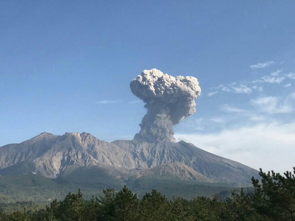
The Aira caldera in the northern half of Kagoshima Bay contains the post-caldera Sakurajima volcano, one of Japan’s most active. Eruption of the voluminous Ito pyroclastic flow accompanied formation of the 17 x 23 km caldera about 22,000 years ago. The smaller Wakamiko caldera was formed during the early Holocene in the NE corner of the caldera, along with several post-caldera cones. The construction of Sakurajima began about 13,000 years ago on the southern rim and built an island that was joined to the Osumi Peninsula during the major explosive and effusive eruption of 1914. Activity at the Kitadake summit cone ended about 4,850 years ago, after which eruptions took place at Minamidake. Frequent eruptions since the 8th century have deposited ash on the city of Kagoshima, located across Kagoshima Bay only 8 km from the summit. The largest recorded eruption took place during 1471-76.
Source : Japan Meteorological Agency (JMA) , GVP.
Photo : Rizal M. (12 /2020)