September 21 , 2024.
Hawaii , Kilauea :
Friday, September 20, 2024, 10:13 AM HST (Friday, September 20, 2024, 20:13 UTC)
19°25’16 » N 155°17’13 » W,
Summit Elevation 4091 ft (1247 m)
Current Volcano Alert Level: WATCH
Current Aviation Color Code: ORANGE
Activity Summary:
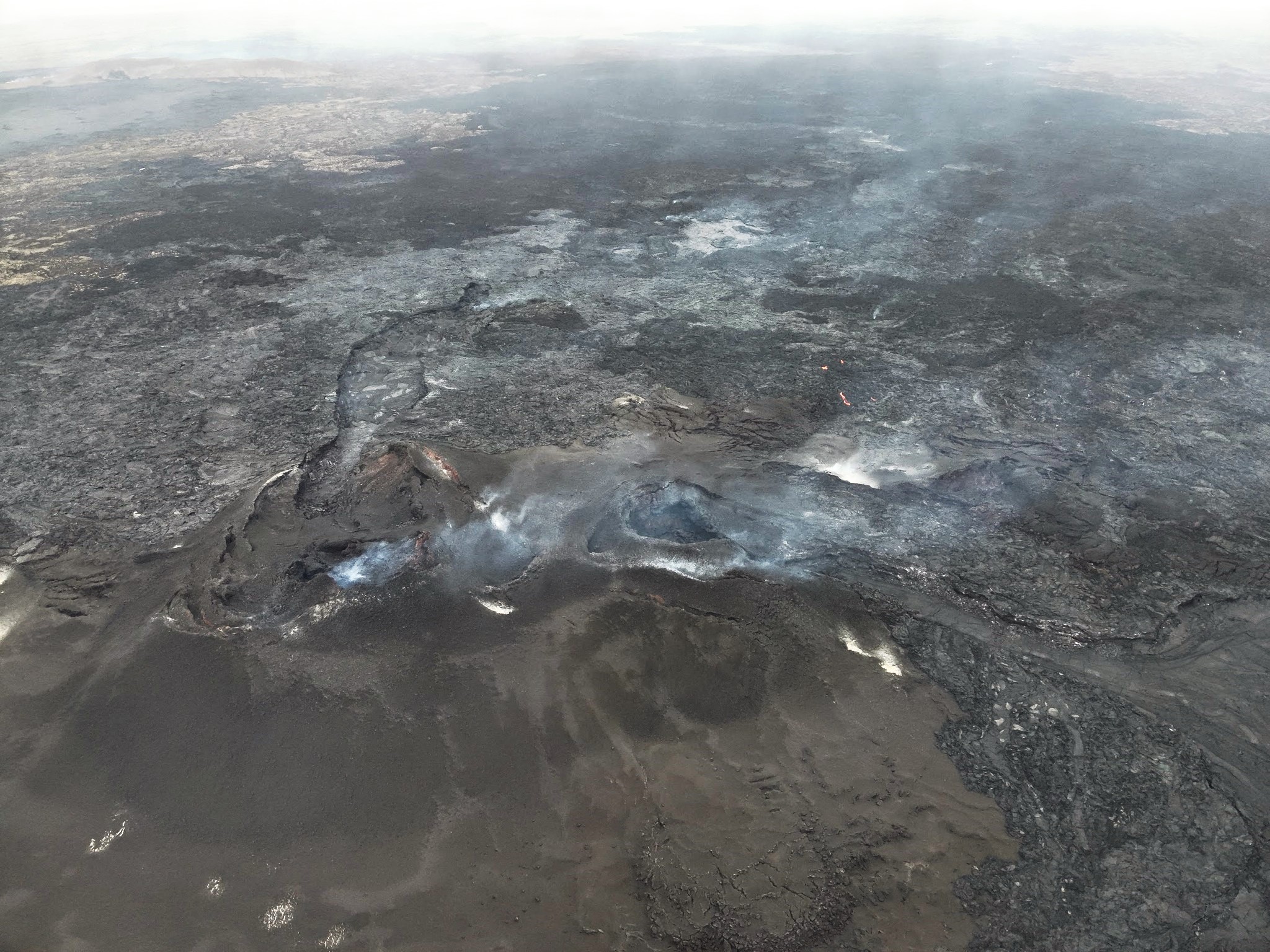
The current eruption of Kīlauea volcano has paused this morning. The large channels and lava falls crusted over between 9 and 10 PM HST last night, September 19. Glow from the vent had decreased significantly by 2:30 AM HST this morning. Field crews reported minor spattering and small fountains at one end of the vent as of 8:30 AM HST, but this had ended by 10 AM HST. This is the fourth phase of fissure activity during the current eruption that began on Sunday night, September 15. The eruption is occurring within a closed and remote area of Hawaiʻi Volcanoes National Park. There is no immediate threat to life or infrastructure. Residents of nearby subdivisions may experience volcanic gas emissions related to this activity which may increase and decrease over the coming hours and days. The Volcano Alert Level/Aviation Color Code remains at WATCH/ORANGE. No changes have been detected in the lower East Rift Zone or Southwest Rift Zone.
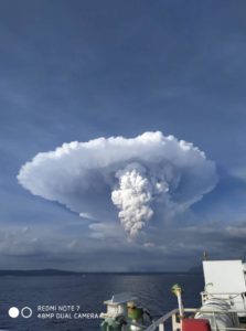
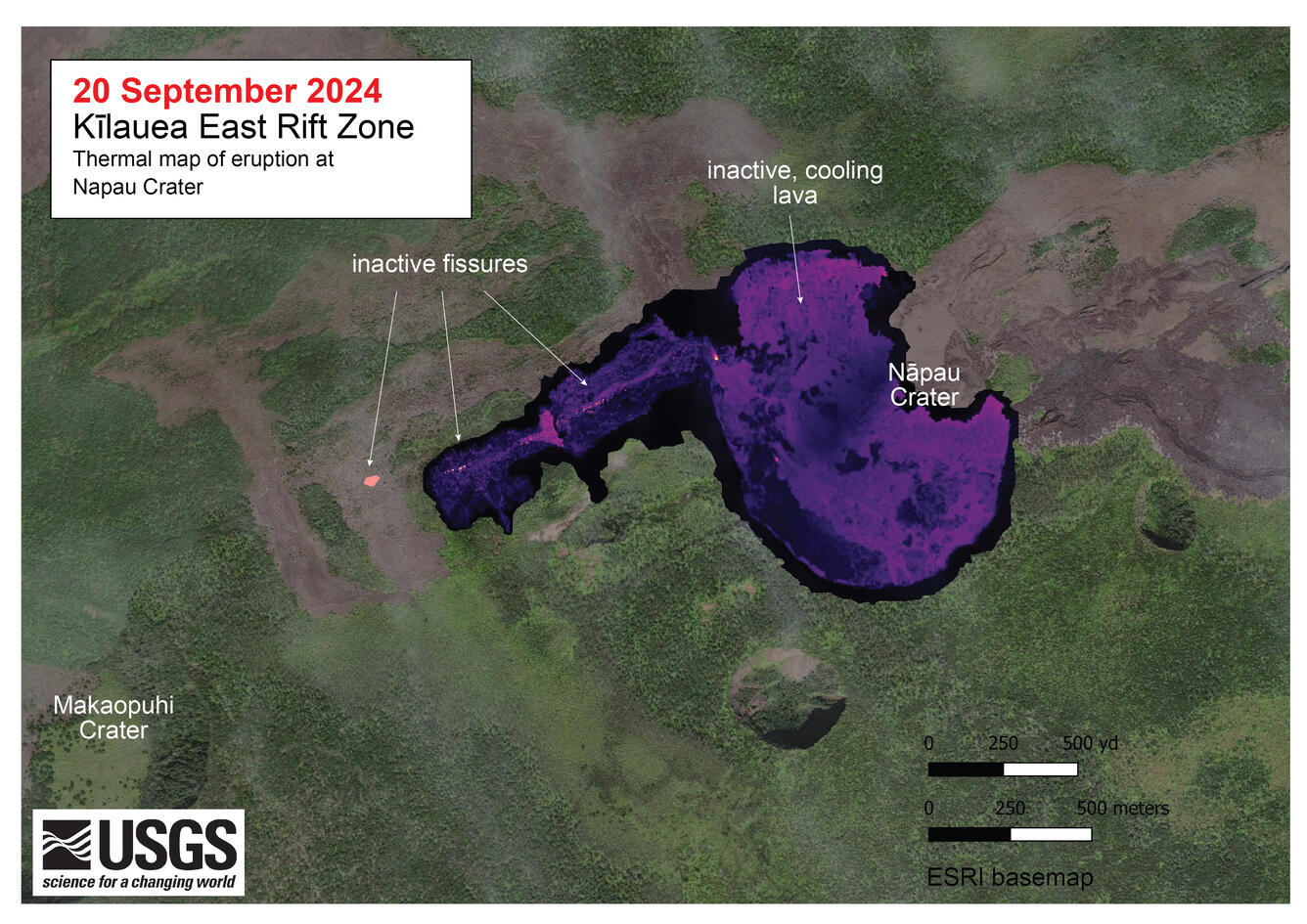
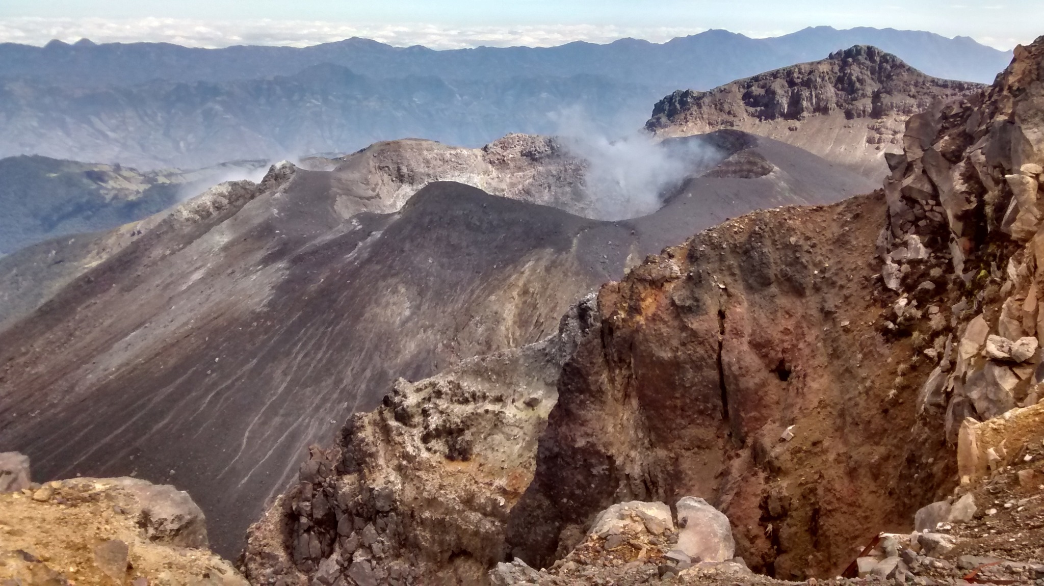
A telephoto view of the fissure that briefly reactivated west of Nāpau Crater this morning, September 20. Low-level fountaining occurred from approximately 8–9:30 a.m. HST.
Summit Observations:
Six small, shallow earthquakes were detected beneath the Kīlauea summit region over the past 24 hours. The tiltmeter at Uēkahuna transitioned sharply from deflation to minor inflation yesterday at about 4:15 PM HST. The summit tiltmeter at Sandhill continues to record strong deflation. This pattern suggests that only the deeper, southern summit magma body is continuing to supply magma to the middle East Rift Zone. The most recent measurement of SO2 emission rate at the summit was 60 tonnes per day on September 17, 2024.
Rift Zone Observations:
The eruptive fissure west of Nāpau Crater diminished greatly overnight. Beginning around 8 PM HST last night the lava channels and falls began to crust over suggesting diminished lava supply. All of the open channels completely crusted over between 9 and 10 PM HST last night. Strong glow from the vent began to diminish around 2:30 AM HST and continued waning until daylight. Mapping this morning shows that lava flows cover about 2/3 of the floor of Nāpau Crater and aren’t significantly larger than they were yesterday. Field crews reported small fountains and lava flows erupting from one of the earlier western fissures this morning at 8:50 AM HST but had stopped by 10:00 AM HST. Effusion rates of roughly 5-15 cubic meters per second (6-16 cubic yards) were estimated during the most active part of yesterday’s fissure eruption. In total, this eruption has covered more than 630,000 square meters (156 acres) of Nāpau Crater and areas to the west since Sunday night.
Shallow earthquake counts remain very low in the MERZ with about 10 in the past 24 hours. Tremor recorded on the MERZ seismometers close to the eruption site decreased significantly late yesterday and early this morning as eruptive activity died down by 2:30 AM HST. Tiltmeters in the MERZ continue to show no significant shallow deformation, but GPS instruments continue to show inflation at deeper levels beneath the area between Maunaulu and Nāpau Crater.
Sulfur Dioxide (SO2) emission rates measured yesterday, September 19, were 30,000 tonnes per day for the new vent that opened in the afternoon.
All activity is currently confined to the middle East Rift Zone between Makaopuhi Crater and Puʻuʻōʻō and there are no indications of any changes further downrift in the MERZ or in the LERZ.
Source : HVO
Photos : USGS / H. Winslow , USGS.
Iceland , Reykjanes Peninsula :
Magma accumulation continues beneath Svartsengi , Updated hazard assessment
Updated 19. September at 17:00 UTC
Uplift at Svartsengi continues at a steady rate
Very little seismicity since the end of the last eruption
Updated hazard assessment. Valid until 3 October, barring any developments
Two weeks have passed since the end of the last eruption in the Sundhnúkur crater row. GPS data indicate that the uplift in Svartsengi continues at a steady rate. Model calculations based on this data estimate that magma accumulation beneath Svartsengi also continues at a similar rate. This trend is similar to what has been observed between the last magma propagations and volcanic eruptions on the Sundhnúkur crater row.
As long as magma accumulation continues beneath Svartsengi and the amount of magma reaches similar levels as prior to recent events, magma propagation and even a volcanic eruption can be expected on the Sundhnúkur crater row. However, it is too early to say when that might occur. Looking at the last two events, it is unlikely that an event will take place in the coming weeks.
The Icelandic Meteorological Office has updated the hazard assessment, which is valid until 3 October, barring any developments.
Considerable changes have been made, the main ones concern the assessment of the hazard due to fissure movements and sinkholes, but these two hazards have been lowered for almost all zones.
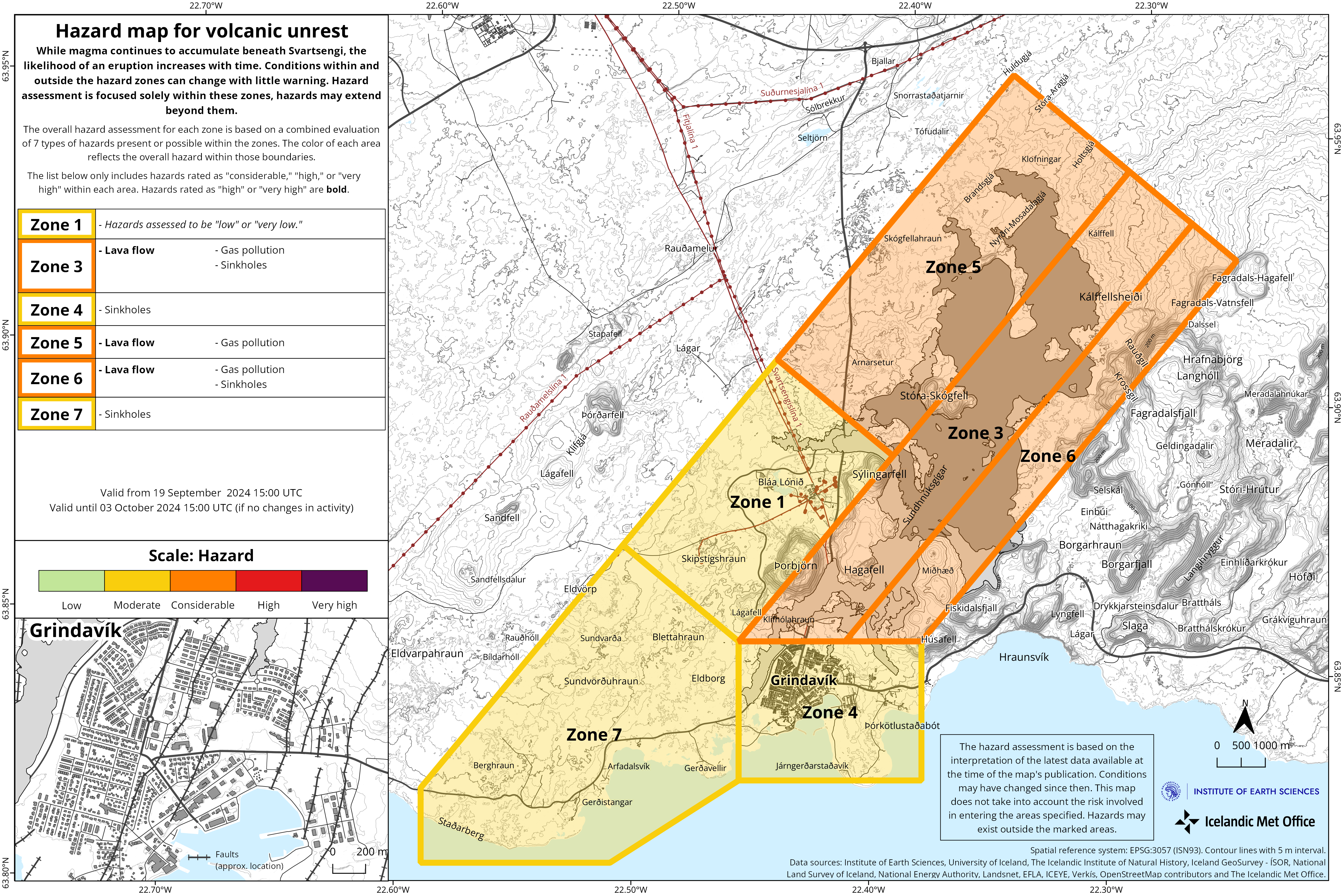
The lava field is still very hot and the hazard from it is therefore considered high in the areas where lava flowed during the last eruption and gas pollution from the lava field is considerable. The hazard from tephra fall is now at the lowest level in all zones.
In the new hazard assessment, the overall hazard for Zone 4 – Grindavík – is assessed as “moderate” (yellow level), but the hazard due to sinkholes is assessed higher, or “considerable”. The Icelandic Meteorological Office would like to point out that the Grindavík Committee is still working on fencing off and marking hazardous areas within the town. The hazard assessment does not take into account such mitigation measures that are considered necessary to prevent possible accidents or damage caused by the hazard that exists at any given time.
In addition to the hazard assessed by IMO, there are other factors that affect how much hazard is associated with staying in the town at any given time, such as limited escape routes, houses that can collapse, the hazard of damaged electrical cables, and due to construction work filling up fissures in the streets.
Source : IMO
Photos : Ljósmynd: Almannavarnir/Björn Oddsson 09/2024 , IMO.
Indonesia , Ibu :
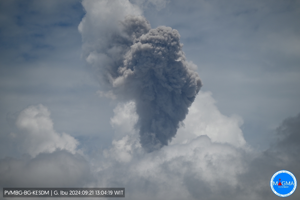
An eruption of Mount Ibu occurred on Saturday, 21 September 2024 at 13:02 WIT with the height of the ash column observed at ± 1,000 m above the summit (± 2,325 m above sea level). The ash column was grey in colour with a thick intensity, oriented towards the North-East. This eruption was recorded on a seismograph with a maximum amplitude of 28 mm and a duration of 68 seconds.
VOLCANO OBSERVATORY NOTICE FOR AVIATION – VONA
Issued : September 21 , 2024
Volcano : Ibu (268030)
Current Aviation Colour Code : ORANGE
Previous Aviation Colour Code : orange
Source : Ibu Volcano Observatory
Notice Number : 2024IBU825
Volcano Location : N 01 deg 29 min 17 sec E 127 deg 37 min 48 sec
Area : North Maluku, Indonesia
Summit Elevation : 4240 FT (1325 M)
Volcanic Activity Summary :
Eruption with volcanic ash cloud at 04h02 UTC (13h02 local).
Volcanic Cloud Height :
Best estimate of ash-cloud top is around 7440 FT (2325 M) above sea level or 3200 FT (1000 M) above summit. May be higher than what can be observed clearly. Source of height data: ground observer.
Other Volcanic Cloud Information :
Ash cloud moving to northeast. Volcanic ash is observed to be gray. The intensity of volcanic ash is observed to be thick.
Remarks :
Eruption recorded on seismogram with maximum amplitude 28 mm and maximum duration 68 second.
Source et photo : Magma Indonésie.
Colombia , Galeras :
San Juan de Pasto, September 17, 2024, 6:25 p.m.
From the monitoring of the activity of the Galeras volcano, the Colombian Geological Survey (SGC), an entity attached to the Ministry of Mines and Energy, reports that:
During the week of September 10 to 16, 2024, the activity of the volcano maintained a stable behavior. Compared to the previous week, the main variations in the monitored parameters were:
● A decrease was recorded in the frequency and energy of earthquakes.
● The predominance of seismicity associated with the fracturing of rocks within the volcanic system remained.
● Fracture earthquakes were located scattered throughout the volcanic area, at distances between 1 and 14 km and at depths between 3 and 15 km from the summit of Galeras, recording a maximum magnitude of 1.9.
● Gas emissions were observed from the main crater and the fumarole fields of Las Chavas, to the west, and El Paisita, to the north of the active cone, with small white columns of variable height and dispersion due to the action of the winds.
● The other volcanic monitoring parameters showed stability.
Based on the above, the SGC recommends closely monitoring the evolution through the weekly bulletins and other information published through our official channels, as well as the instructions of the local and departmental authorities and the National Disaster Risk Management Unit (UNGRD).
Volcanic activity remains in yellow alert status: active volcano with changes in the behavior of the base level of the monitored parameters and other manifestations.
Source et photo (07/2024) : SGC.
La Martinique , Mount Pelée :
Weekly report, Institute of Earth Physics of Paris. Volcanological and Seismological Observatory of Martinique
Saint-Pierre, September 20, 2024 at 3:00 p.m. local time (GMT-4)
Volcanic activity remains significant this week with 53 earthquakes of volcanic origin observed.
Between September 13, 2024 at 4:00 p.m. (UT) and September 20, 2024 at 4:00 p.m. (UT), the OVSM recorded:
• 52 low-energy volcano-tectonic earthquakes. These earthquakes were clearly identified as coming from one of the well-known seismically active zones at Mount Pelée, located between 1.0 and 1.4 km deep below the summit of the volcano. The superficial volcano-tectonic seismicity is associated with micro-fracturing in the volcanic edifice in connection with the global reactivation of the volcano observed since the end of 2018.
• 1 deep hybrid earthquake located directly above the volcano at a depth of approximately 22 km. Hybrid seismic signals are enriched in low frequencies and are generally associated with the presence of magmatic fluids in the depths of the volcanic system of Mount Pelée.
No earthquake was felt by the population.
The previous week, the OVSM had recorded 56 earthquakes of volcanic origin. As of September 20, 2024 and during the last 4 weeks, the OVSM has therefore observed a total of 125 volcanic earthquakes, an average of 31 to 32 earthquakes per week.
During the volcanic reactivation phases of volcanoes similar to Mount Pelée, it is usual to observe seismic activity that varies in intensity and frequency.
The alert level is currently YELLOW: vigilance.
Source : Direction de l’OVSM-IPGP . https://www.ipgp.fr/communiques-et-bulletins-de-lobservatoire/?categorie=&domaine=&date=&observatoire-associe=399&motcle=
Photo : Jmp48 / Wikipedia ( 01/2021)