September 15 , 2024.
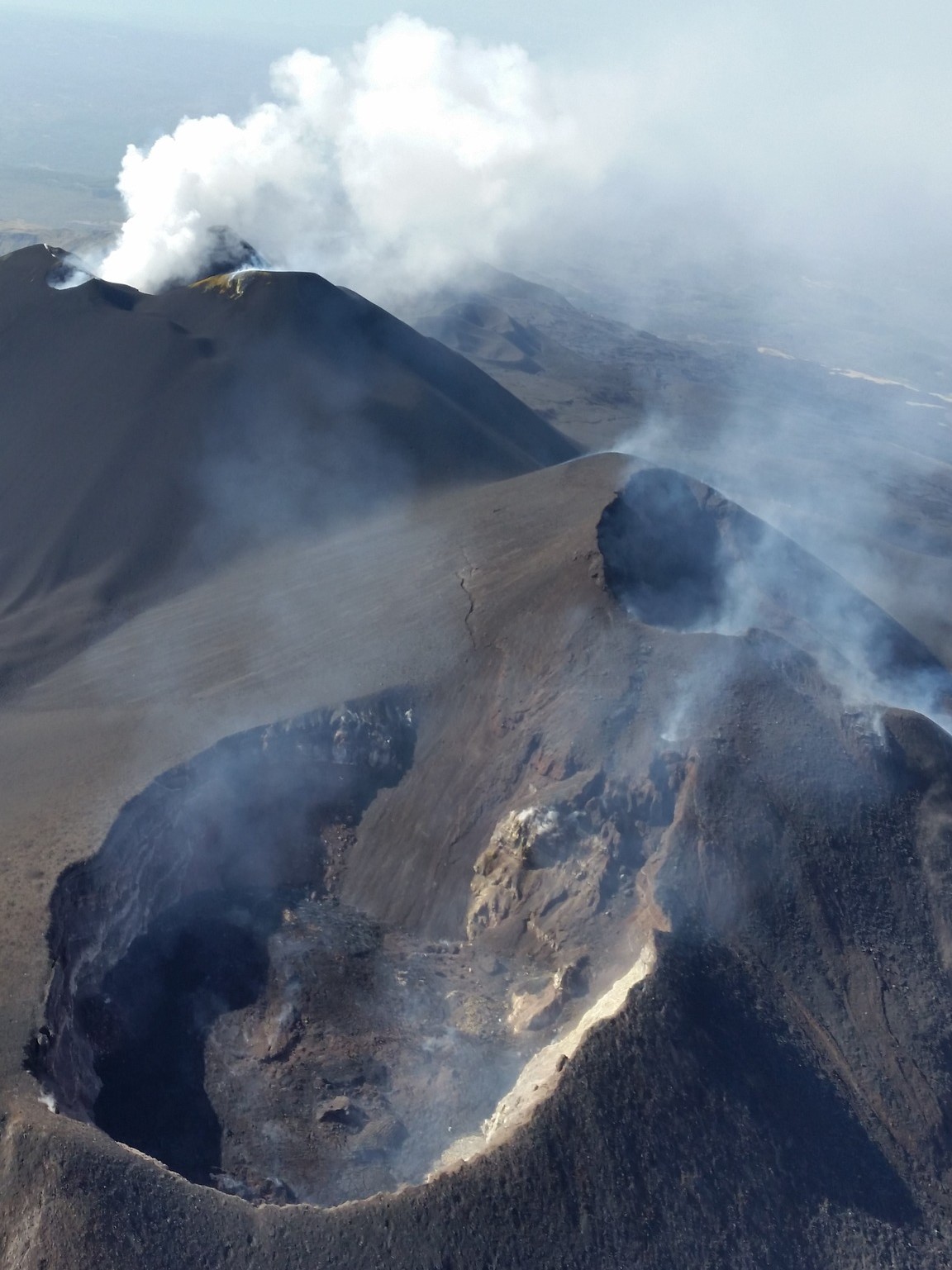
Italy / Sicily , Etna :
Etna activity statement, 14 September 2024, 10:47 (08:47 UTC) .
The National Institute of Geophysics and Volcanology, Osservatorio Etneo, reports the observations made by video surveillance cameras that highlight that the degassing activity continues at the summit craters, mainly affecting the Voragine and the South-East crater. Despite the presence of strong winds and cloud cover in the summit area, no significant changes in volcanic activity are currently observed. The average amplitude of the volcanic tremor showed a progressive increase starting from the early hours of today. From 07:40 UTC, following a rapid increase, the amplitude reaches high values where it is still maintained. The center of gravity of the tremor sources is located in the area of the Bocca Nuova crater, at an altitude of about 3,000 meters. As regards infrasound activity, the presence of strong wind in the summit area, which affects the detection of infrasound events and their location, does not allow to express evaluations in this regard. From the point of view of deformations, there are no significant variations at the moment.
Etna Activity Report, 15 September 2024, 00:22 (22:22 UTC) .
The National Institute of Geophysics and Volcanology, Osservatorio Etneo, reports that after the last press release at 08:47 UTC, degassing activity continued at the summit craters, mainly affecting the Voragine and the Southeast Crater, as evidenced by video surveillance cameras.
Currently, there is cloud cover in the summit area and no significant changes in volcanic activity are observed. The average amplitude of the volcanic tremor decreased until reaching the low value range around 11:30 UTC. From 18:30 UTC, a new phase of increase began which, around 20:50 UTC, brought the amplitude to high values, where it is still maintained. The centroid of the tremor sources is located in the Bocca Nuova crater area at an altitude of about 2900 m.
Concerning the infrasound activity, the decrease in wind intensity in the summit area allowed to detect the almost total absence of events. The ground deformation monitoring networks do not show significant variations.
Further updates will be communicated shortly.
Source : INGV
Photo : Joseph Nasi / FB ( 8/2024) .
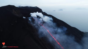
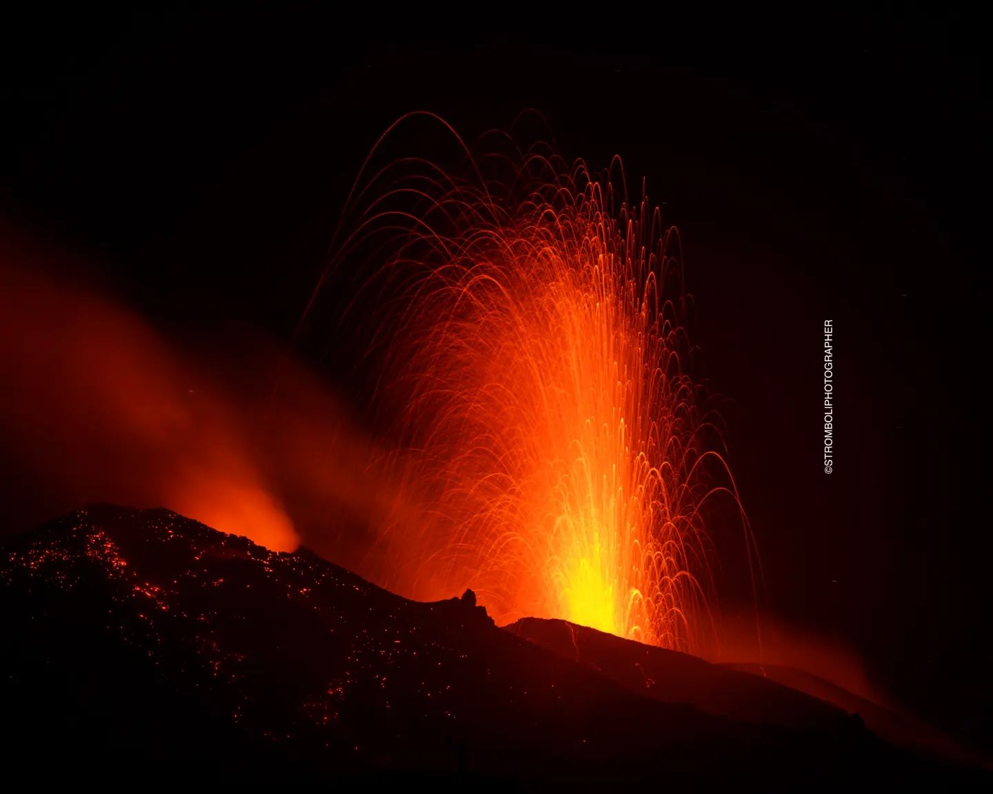
Italy , Stromboli :
Stromboli Activity Statement, 14 September 2024, 22:40 (20:40 UTC) .
The National Institute of Geophysics and Volcanology, Osservatorio Etneo, announces that the effusive activity reported in the press release of 23:27 UTC on 13-09 has ended.
A weak spattering activity and Strombolian explosions persist at the mouths of the northern area of the crater. Occasional landslides are also observed along the Sciara del Fuoco.
Regarding the amplitude of the volcanic tremor, following the increase phase reported in the press release of 23:27 UTC on 13-09, a gradual decrease has been observed. From about 15:45 UTC, the amplitude reached the medium range, where it is still maintained, with some peaks at high values.
The amplitude of the explosion earthquakes remains low.
Ground deformation monitoring networks do not detect significant changes.
Further updates will be communicated shortly.
Source : INGV
Photo : Stromboli stati d’animo / Sebastiano Cannavo
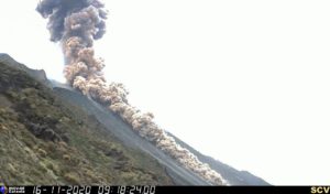
Indonesia , Marapi :
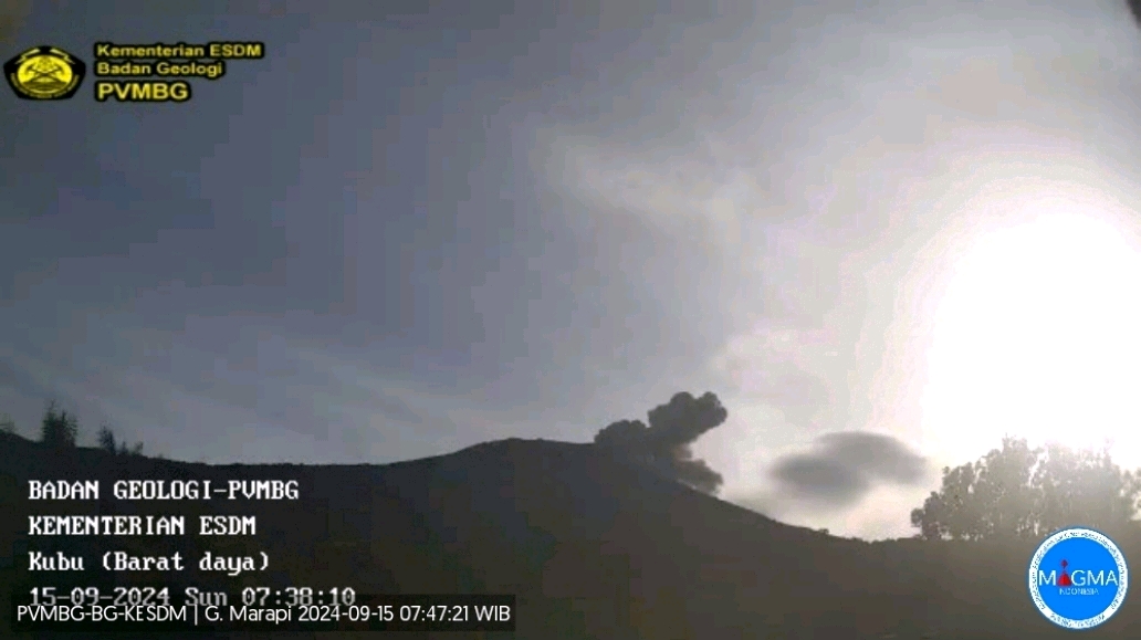
An eruption of Mount Marapi occurred on Sunday, September 15, 2024 at 07:36 WIB with the height of the ash column observed at ± 400 m above the summit (± 3291 m above sea level). The ash column was observed to be gray with a thick intensity, oriented towards the East. This eruption was recorded on a seismograph with a maximum amplitude of 4.5 mm and a duration of 211 seconds.
VOLCANO OBSERVATORY NOTICE FOR AVIATION – VONA
Issued : September 15 , 2024
Volcano : Marapi (261140)
Current Aviation Colour Code : ORANGE
Previous Aviation Colour Code : orange
Source : Marapi Volcano Observatory
Notice Number : 2024MAR079
Volcano Location : S 0 deg 22 min 52 sec E 100 deg 28 min 23 sec
Area : West Sumatra, Indonesia
Summit Elevation : 9251 FT (2891 M)
Volcanic Activity Summary :
Eruption with volcanic ash cloud at 0036 UTC (0736 local).
Volcanic Cloud Height :
Best estimate of ash-cloud top is around 10531 FT (3291 M) above sea level or 1280 FT (400 M) above summit. May be higher than what can be observed clearly. Source of height data: ground observer.
Other Volcanic Cloud Information :
Ash cloud moving to east. Volcanic ash is observed to be gray. The intensity of volcanic ash is observed to be thick.
Remarks :
Eruption recorded on seismogram with maximum amplitude 4.5 mm and maximum duration 211 second.
Source et photo : Magma Indonésie.
Hawaii , Kilauea :
HAWAIIAN VOLCANO OBSERVATORY INFORMATION STATEMENT . U.S. Geological Survey
Saturday, September 14, 2024, 5:07 PM HST
Current Volcano Alert Level: ADVISORY
Current Aviation Color Code: YELLOW
On Saturday, September 14, 4:25 p.m. HST, a magnitude-4.3 earthquake occurred 4 mi (6 km) south-southwest of Volcano on the Island of Hawaiʻi at a depth of 0.2 mi (0.3 km) below sea level. The earthquake had no apparent impact on either Mauna Loa or Kīlauea volcanoes.
The size, location, and character of this earthquake suggests that it is related to the ongoing pressurization of the magma storage system beneath Kīlauea’s summit area, which extends into the upper East Rift Zone, where intrusions of magma have recently occurred. Several aftershocks were detected within the first 30 minutes after the earthquake, as is typical for an event of this size. Additional aftershocks are expected to be minor, but may continue for day to weeks.

The USGS Hawaiian Volcano Observatory continues to monitor Hawaiian volcanoes for any changes.
EARTHQUAKE DESCRIPTION
Magnitude: 4.3
Date and Time: September 14, 2024, at 4:25 p.m. HST
Location: 4 mi (6 km) SSW of Volcano
Depth: 0 mi (0 km) below sea level
Aftershocks are possible in the coming days to weeks
Source : HVO
Photo : Keanakākoʻi Crater NPS /M. Szoenyi ( 05 / 2024)
La Guadeloupe , La Soufrière :
Monthly Bulletin, Institut de physique du globe de Paris / Observatoire volcanologique et seismologique de Guadeloupe, August 2024.
– Seismicity:
617 volcano-tectonic (VT) earthquakes occurred regularly (no swarms) in the volcano area. The vast majority, of negative magnitude, occurred less than 1 km deep under the Soufrière dome. About twenty slightly more energetic earthquakes (M < 1.1) occurred 2 km below sea level, under and in the immediate vicinity of the volcano, mainly between August 6 and 8, and August 14. The total energy released (7.3 MJ) is slightly up compared to the previous month (6.5 MJ).
– Deformation:
after a slowdown in early 2024, the opening of the dome summit has resumed a normal regime
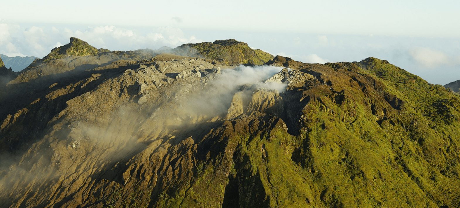
– Gas and fluids:
– the maximum fumarole temperatures (196°C at CSS, 136°C at CSN, and 95°C at NAPN) are slightly decreasing compared to the peak temperature of 2023.
– the composition of the Soufrière gas plume does not show any major change
– the level of Lake Tarissan (-84.5 m) is stable and its pH (+0.25) is slightly increasing
Based on the observations summarized in this bulletin, and in accordance with the provisions provided by the authorities, the volcanic alert level remains on Alert: Yellow
Regional telluric activity
– Medium intensity activity with 176 earthquakes (maximum magnitude of 4.3) recorded on the regional fault networks, including 40 earthquakes in the Saintes area. No earthquakes were felt by the population.
Source et photo : IPGP https://www.ipgp.fr/communiques-et-bulletins-de-lobservatoire/?categorie=&domaine=&date=&observatoire-associe=398&motcle=
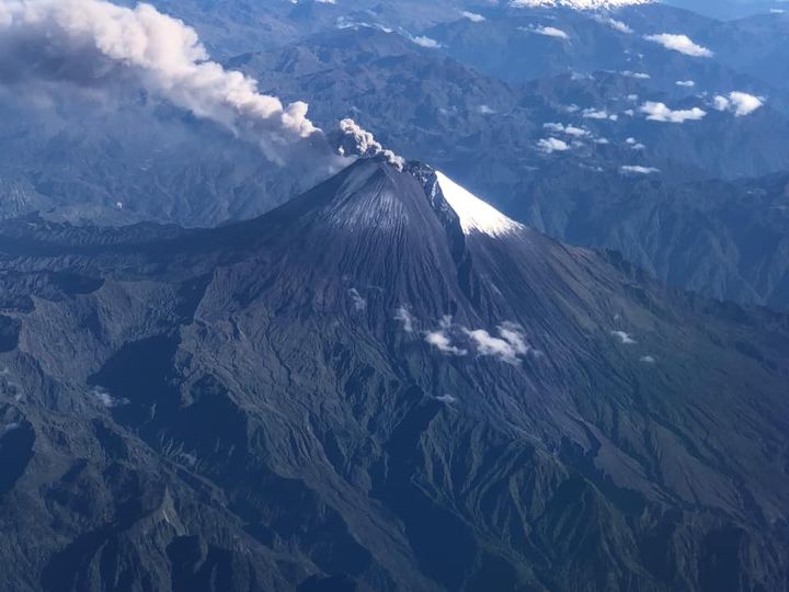
Ecuador , Sangay :
DAILY STATE REPORT OF SANGAY VOLCANO , Saturday, September 14, 2024 .
Information Geophysical Institute – EPN.
Surface Activity Level: High , Surface Trend: Descending
Internal Activity Level: High , Internal Trend: No change
Seismicity: From September 13, 2024, 11:00 a.m. to September 14, 2024, 11:00 a.m.:
Seismicity:
Below is the count of seismic events recorded at the reference station
Explosion (EXP): 180
Rainfall / Lahars:
No rain has been recorded in the volcano area. **In the event of heavy rain, it could remobilize the accumulated materials, generating mud and debris flows that would descend the sides of the volcano and flow into adjacent rivers.
Emissions / Ash Column:
Since yesterday evening, thanks to surveillance cameras, gas and ash emissions have been observed at heights below 700 meters above the crater level in a southwest direction. In addition, the W-VAAC agency has published 3 reports of ash emissions, with heights between 500 and 1,500 meters above the crater level, in the southeast and west-southwest directions.
Gas:
The MOUNTS satellite system recorded 20.5 tons of sulfur dioxide (SO2) measured on 09/13/2024 at 13:45 TL.
Other monitoring parameters:
The MIROVA-VIIRS satellite system detected 2 thermal anomalies, MIROVA-MODIS recorded 2 thermal anomalies and the FIRMS system recorded 20 thermal alerts.
Observation:
Thanks to the surveillance cameras, since yesterday evening, several episodes of incandescence have been observed descending up to 1000 meters below the summit level. At the time of this report, the volcano is cloudy.
Alert level: yellow
Source : IGEPN
Photo : volcan sangay FDB / auteur inconnu ( 9/2022)