August 21 , 2024.
Italy , Stromboli :
WEEKLY BULLETIN, from August 12, 2024 to August 18, 2024. (issue date August 20, 2024)
SUMMARY STATUS OF ACTIVITY
In light of the monitoring data, it appears:
1) VOLCANOLOGICAL OBSERVATIONS: Ordinary explosive activity with an hourly frequency of total activity at an average level and an effusive activity of lava overflow towards the northern area of the crater.
2) SISMOLOGY: The monitored seismological parameters do not show significant variations.
3) GROUND DEFORMATION: Data from the ground deformation monitoring networks showed deformation transients from 07:00 UTC on 08/18/2024.
4) GEOCHEMISTRY: SO2 flux at a moderately medium-high and high level on August 15.
Soil CO2 flux in the Pizzo area in average values
C/S ratio in the plume in average values
Helium isotope ratio: no updates
Soil CO2 flux in the Mofete site: medium-high values
Soil CO2 flux in the waste area: high values
5) SATELLITE OBSERVATIONS: The thermal activity observed by satellite in the summit area was generally of a moderate level with some isolated high-level thermal anomalies corresponding to the intense lava spattering and overflow activity in the Sciara del Fuoco on 15 August.
VOLCANOLOGICAL OBSERVATIONS
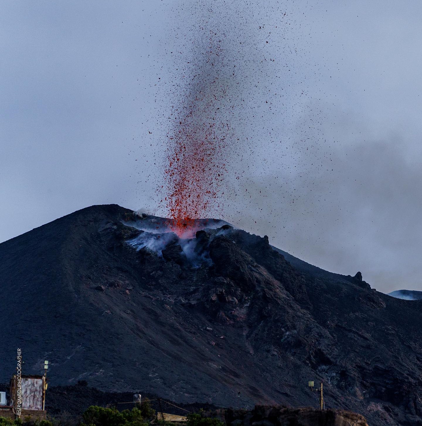
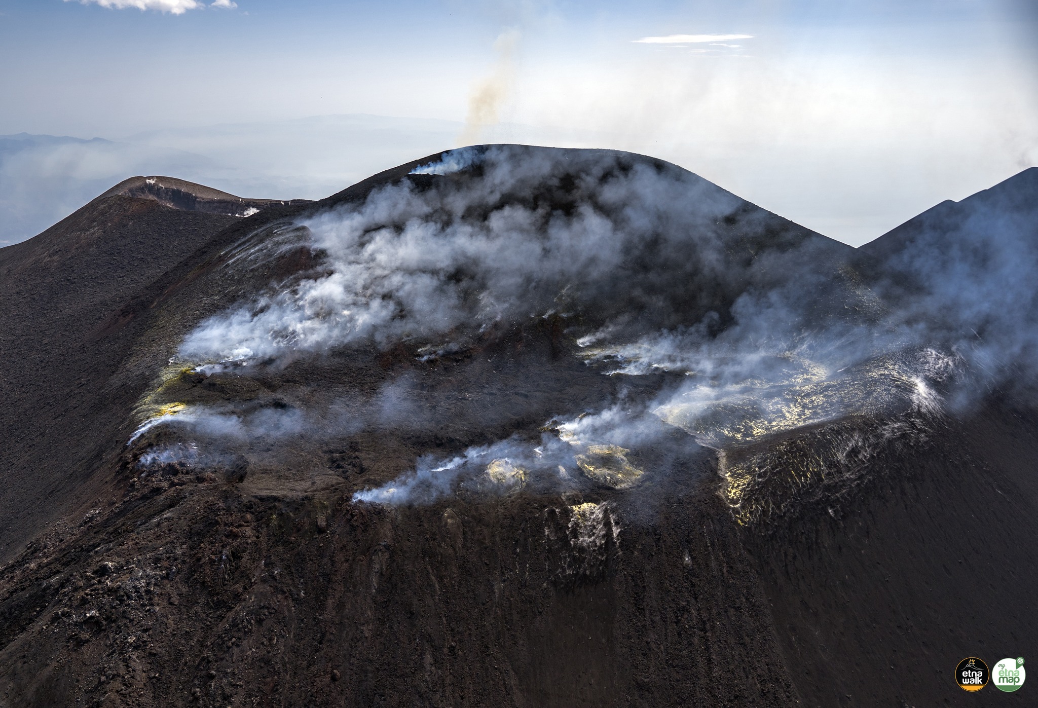
During the week, the activity of Stromboli was observed through the INGV surveillance cameras and through direct observation by INGV personnel. The explosive activity was mainly produced by 3 (three) eruptive vents located in the northern area of the crater and by 1 (one) vent located in the central southern area.
Observations of the explosive activity captured by the surveillance cameras.
The explosive activity in the northern area of the crater was produced by 3 vents, among which the vent located in the southernmost sector of the crater terrace is characterized by fueling a projection activity of variable intensity and regime. Overall, the explosions were of variable intensity with an hourly frequency of medium level and with erupted products mainly of coarse materials (bombs and lapilli). In the South-Central area, the explosions were mostly dominated by fine materials, sometimes mixed with coarse materials. The average frequency of explosions remained low.
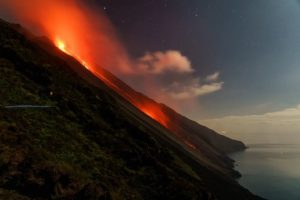
Effusive activity on 15 August 2024
On 15 August at around 16:45 UTC, an effusive activity originating from lava overflow began at the peak of a phase of intense spattering activity in the North Crater area. The activity produces a lava flow that propagates rapidly along the ravine located in the Sciara del Fuoco produced during the recent eruptive activity in July. After about 3 hours, the energy of the event decreases and the lava flow, no longer fed, appears to cool down at 20:10 UTC. The lava front reached a maximum altitude of about 450 meters above sea level.
Source : INGV.
Photo : Stromboli stati d’animo / Sebastiano Cannavo. ( 04/2024)
Italy / Sicily , Etna:
WEEKLY BULLETIN, from August 12, 2024 to August 18, 2024. (issue date August 20, 2024)
SUMMARY STATUS OF ACTIVITY
In light of the monitoring data, it emerges:
1) VOLCANOLOGICAL OBSERVATIONS: Strombolian activity and lava fountain event on August 14-15 at the Voragine crater, explosive activity and degassing at the Bocca Nuova crater on August 18 and degassing at the Southeast crater.
2) SEISMOLOGY: Absence of fracturing seismic activity with Ml>=2.0. Strong volcanic tremor during the lava fountain of August 14. In the following days, the amplitude of the tremor oscillated between the average value and the low value.
3) INFRASOUND: Infrasound activity was mostly high between 12 and 14 August. Low infrasound activity for the rest of the week.
4) GROUND DEFORMATIONS: Ground deformation monitoring networks recorded variations related to the paroxysmal episode of 14-15 August.
5) GEOCHEMISTRY: SO2 flux at low level
CO2 flux from the ground slightly increased compared to average values.
CO2 dissolved in groundwater does not show significant variations.
There is no update on the helium isotope ratio; the latest data from 9 July were at a high level.
6) SATELLITE OBSERVATIONS: Thermal activity observed by satellite in the summit area was generally of a moderate level with high to very high values corresponding to the activity of the lava fountain of 14 August 2024.
VOLCANOLOGICAL OBSERVATIONS
During the week, the monitoring of the volcanic activity of Etna was carried out thanks to the analysis of the images of the surveillance cameras of the INGV – Osservatorio Etneo (INGV-OE) and to the observations made by the INGV-OE staff during two inspections carried out on 15 and 16 August.
In general, during the observation period, Etna was characterized by an eruptive activity with variable regime from the Voragine crater (VOR) and the Bocca Nuova crater (BN), and by a continuous degassing of variable intensity in the South-East crater (CSE).
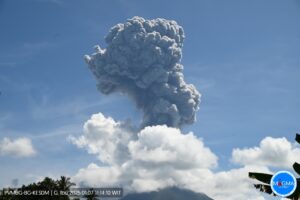
In particular, on 12 and 13 August, the Voragine crater (VOR) also fed the Strombolian activity by throwing lava flaps along the sides of the cinder cone. In the early afternoon of 14 August and especially from around 18:00 UTC, surveillance cameras showed an intensification of the Strombolian activity that gradually transformed into a lava fountain from around 22:30 UTC. The paroxysmal event gradually ended from around 00:30 UTC on 15 August, ceasing at 01:20 UTC, about 3 hours later. The end of the phenomenon was marked by an explosion recorded at 01:28 UTC lasting about 2 min, which was followed by moderate Strombolian activity that gradually decreased in intensity. The lava fountain produced an eruptive cloud that, in its most intense phase, reached a height of about 9.5 km above sea level and was dispersed mainly in the south-southwest and east-southeast quadrants. The fallout affected several inhabited centres including Belpasso, Pedara, Nicolosi, Ragalna, Mascalucia, Tremestieri Etneo, Gravina di Catania, Catania, Viagrande, Milo, Zafferana, Santa Tecla, Giarre, Santa Venerina and Aci Bonaccorso. Furthermore, fallout of pyroclastic products was also reported in Syracuse.
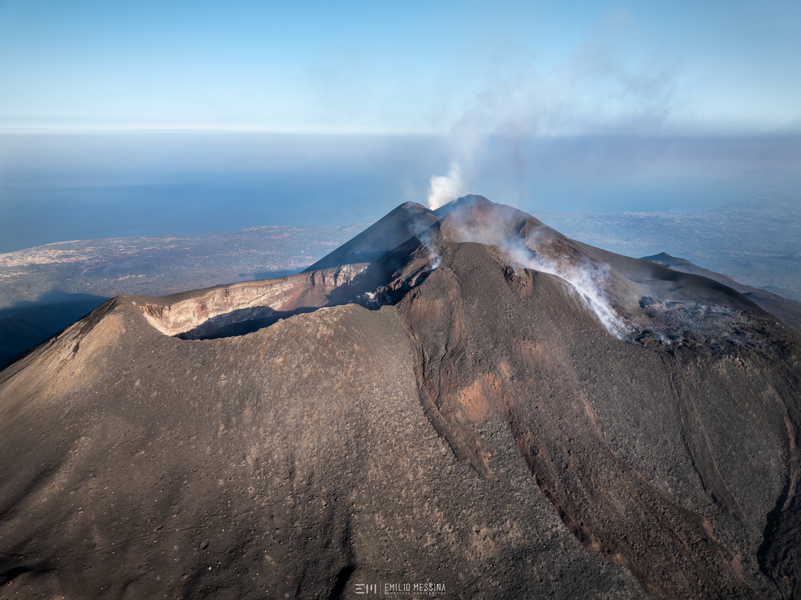
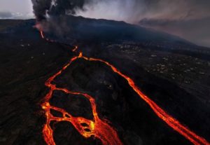
During the lava fountain, lava flows also occurred which, as in the case of the previous fountains, overflowed the western rim of the Bocca Nuova crater. During the inspection of 15 August, two lava flows were identified, partially overlapping the lava field created during the lava fountain of 4 August, whose most advanced fronts were confined to an altitude of about 3000 m above sea level, other lava flows were recognized, which overflowed the rim of the Bocca Nuova and headed further southwest. In general, the fountain event of 15 August contributed to the morphological variation of the summit area of Etna determined by the recent activity of the Voragine. The accumulation of pyroclastic deposits and the overlapping of lava flows have in fact affected the subsequent filling of the Bocca Nuova, as well as the partial filling of the North-East Crater (CNE). In fact, the paroxysmal event also involved the North-East side of the Voragine, leading to the discharge of eruptive products also within the North-East Crater.
In the early morning of 18 August, two explosive sequences were recorded at 02:30 and 02:59 UTC lasting respectively about 4-6 min, probably determined by the reopening of the North Pit of the Bocca Nuova. Both sequences generated a thermal anomaly and the development of two eruptive clouds that rapidly dispersed in the summit area in an East-North-East direction. Subsequently, the Bocca Nuova caused an almost continuous degassing. At the same time, the continuation of a modest Strombolian activity of the Voragine was observed.
Source : INGV.
Photos : Etna Walk/ Giuseppe Distefano ( 03/08/2024) , Emilio Messina Photography by FB ( 16/08/2024 )
Iceland , Reykjanes Peninsula :
The Likelihood of a Magma Intrusion and Possible Eruption at the Sundhnúkar Crater Row Remains High
Hazard Assessment and Scenarios Remain Unchanged
Updated 20 August at 15:00 UTC
A trend of increasing seismic activity has been observed in recent days.
Two earthquakes exceeding magnitude 2 were recorded last night.
Clear signs of increasing pressure are observed in the area.
Magma accumulation and land uplift continue at a steady rate compared to recent days.
The volume of magma beneath Svartsengi is greater than it was before prior eruptions in the region.
Seismic activity around the Sundhnúkar Crater Row continues to exhibit behavior similar to that observed in the days leading up to the most recent eruption, which began on May 29. Two earthquakes with magnitudes above 2 were recorded last night, bringing the total to six such earthquakes in the past week.
The seismic activity indicates that pressure continues to build in the area due to magma accumulation under Svartsengi.
The progression of magma accumulation and land uplift has remained unchanged in recent days. Model calculations show that the total volume of magma beneath Svartsengi is now greater than it was before the previous events.
The likelihood of a new magma intrusion and perhaps an eruption in the Sundhnúkar Crater Row remains high.
Source : IMO
Photo : Siggi Anton
Hawaii , Kilauea :
Tuesday, August 20, 2024, 8:55 AM HST (Tuesday, August 20, 2024, 18:55 UTC)
19°25’16 » N 155°17’13 » W,
Summit Elevation 4091 ft (1247 m)
Current Volcano Alert Level: ADVISORY
Current Aviation Color Code: YELLOW
Activity Summary:
Kīlauea is not erupting. Increased earthquake activity and rates of ground deformation at Kīlauea’s upper East Rift Zone (UERZ) began last night at approximately 9:00 PM HST. The activity peaked around 2:00 AM and continues at a reduced rate this morning. Changes in the character and location of unrest can occur quickly, as can the potential for eruption, but there are no signs of imminent eruption at this time. There are no significant changes in activity in the lower East Rift Zone and Southwest Rift Zone.
Summit Observations:
Approximately 16 earthquakes were detected beneath Kaluapele (Kīlauea’s summit caldera) over the past 24 hours. Most were located south of Halema‘uma‘u and near Keanakākoʻi Crater at depths of 1–3 km (0.6–1.9 mi) below the ground surface with magnitudes of less than M2.0. Rates of deformation at the summit remained relatively low with minor local deflation, likely in response to unrest in the upper East Rift Zone (UERZ). An overall gradual inflationary trend continues to be seen on GPS instruments around the summit region. The most recent measurement of the summit’s SO2 emission rate was approximately 70 tonnes per day on August 13, 2024.

Rift Zone Observations:
Over the past 8 hours, there have been approximately 200 earthquakes beneath Kīlauea’s UERZ region, extending from Puhimau Crater southeast to Maunaulu. Activity peaked between 1:00 and 2:00 AM HST, and earthquakes have been occurring at decreasing rates since then. Most earthquakes have been smaller than M2.0, though there were 6 events larger than M3.0. The largest earthquake was a M3.7 at 2:21 AM HST. Events have remained at depths of 1–3 km (0.6–1.8 miles) beneath the surface. Most earthquakes have been too small to feel, but several were reported felt in Hawaiʻi Volcanoes National Park and surrounding communities.
Earthquake activity has been accompanied by elevated rates and changing patterns of ground deformation recorded by the ESC tiltmeter in Kīlauea’s UERZ. Rates of deformation have decreased since about 4:30 AM HST but remain elevated. Tiltmeters in Kīlauea summit region (instruments SDH, southwest of the summit, and UWE, northwest of the summit) have shown minor deflationary trends since about midnight, likely associated with the UERZ unrest.
Activity in the middle East Rift Zone (MERZ) remains low with approximately 25 earthquakes detected in the past 24 hours. Earthquake locations are scattered between Maunaulu and Puʻuʻōʻō within Hawaiʻi Volcanoes National Park. Depths range from 1–3 km (0.6–1.9 mi) below the ground surface with magnitudes less than M2.0. There has been no significant change in deformation at the POC tiltmeter overnight. GPS instruments continue to record inflation in the region.
Measurements from continuous gas monitoring stations downwind of Puʻuʻōʻō in the middle East Rift Zone—the site of 1983–2018 eruptive activity—remain below detection limits for SO2, indicating that SO2 emissions from this area are negligible.
At this time, there is no evidence of seismicity or ground deformation beneath the lower East Rift Zone, and Southwest Rift Zone activity remains low. Current activity is restricted to the summit and upper East Rift Zone region.
Source : HVO
Photo : USGS/ M. Patrick.( 05/2024)
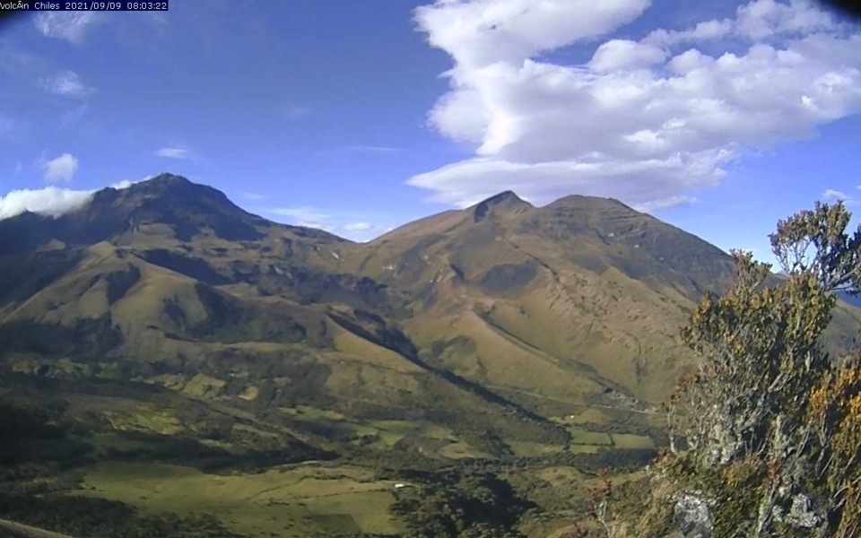
Colombia , Chiles / Cerro Negro :
Pasto, August 20, 2024, 6:55 p.m.
From the monitoring of the activity of the Chiles and Cerro Negro volcanoes, the Colombian Geological Survey (SGC), an entity attached to the Ministry of Mines and Energy, reports that:
During the week of August 13 to 19, 2024, the activity of these volcanoes maintained a stable behavior. Compared to the previous week, the main variations in the monitored parameters were:
• A slight increase was recorded both in the frequency of earthquakes and in the energy released.
• The predominance of seismicity associated with the fracturing of rocks in the volcanic edifice continues, followed by seismic activity related to the movement of fluids within these volcanoes, presenting some of these events with very low frequency content.
• Some of the earthquakes related to fracture processes were located in the collapse zone of the Chiles volcano, to the north of its summit, at distances of less than 2 km and at depths of between 2 and 5 km from the summit (4,700 m above sea level). Other events occurred between the southwest and southeast of the summit of the Chiles volcano, at distances of up to 12 km and at depths of up to 8 km. In addition, earthquakes were recorded at distances of up to 7 km to the north, all referenced to the summit of the Chiles volcano.
The highest magnitude earthquake during the assessed period was 1.4.
• Field deformation sensors and remote satellite sensors continue to record changes associated with an inflationary process in the volcanic area.
Based on the above, the SGC recommends closely monitoring its evolution through weekly bulletins and other information published through our official channels, as well as instructions from local and departmental authorities and the National Disaster Risk Management Unit (UNGRD).
Volcanic activity remains in YELLOW alert status: active volcano with changes in the behavior of the base level of the monitored parameters and other manifestations.
Source et photo : SGC