August 13 , 2024.
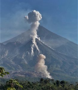
Kamchatka , Sheveluch :
56.64 N, 161.32 E;
Elevation 3283 m (10768 ft), the dome elevation ~2500 m (8200 ft)
Aviation Colour Code : ORANGE
An extrusive-effusive eruption of the Young Sheveluch volcano continues. Ash explosions up to 10 km (32,800 ft) a.s.l. could occur at any time. Ongoing activity could affect international and low-flying aircraft.
A new lava block began to be extruding out between the western wall of the crater and the lava dome.
An extrusive-effusive eruption of the Young Sheveluch volcano continues: a lava is extruding out in the northern part of the explosive crater. The growth of a new lava dome, called “300 years of RAS” (the Russian Academy of Sciences), continues on the southwestern slope of the Old Sheveluch volcano. The growth of the domes are accompanied by powerful gas-steam activity. According to KVERT satellite data, plumes of resuspended ash were extending for 210 km to the southeast of the volcano on 03-05 August; thermal anomalies were observed in the areas of both domes on 02-06 August, the volcano was obscured by clouds in the other days of the week
Source: Kvert
Photo : Yu. Demyanchuk. IVS FEB RAS, KVERT ( 31/7/2024)
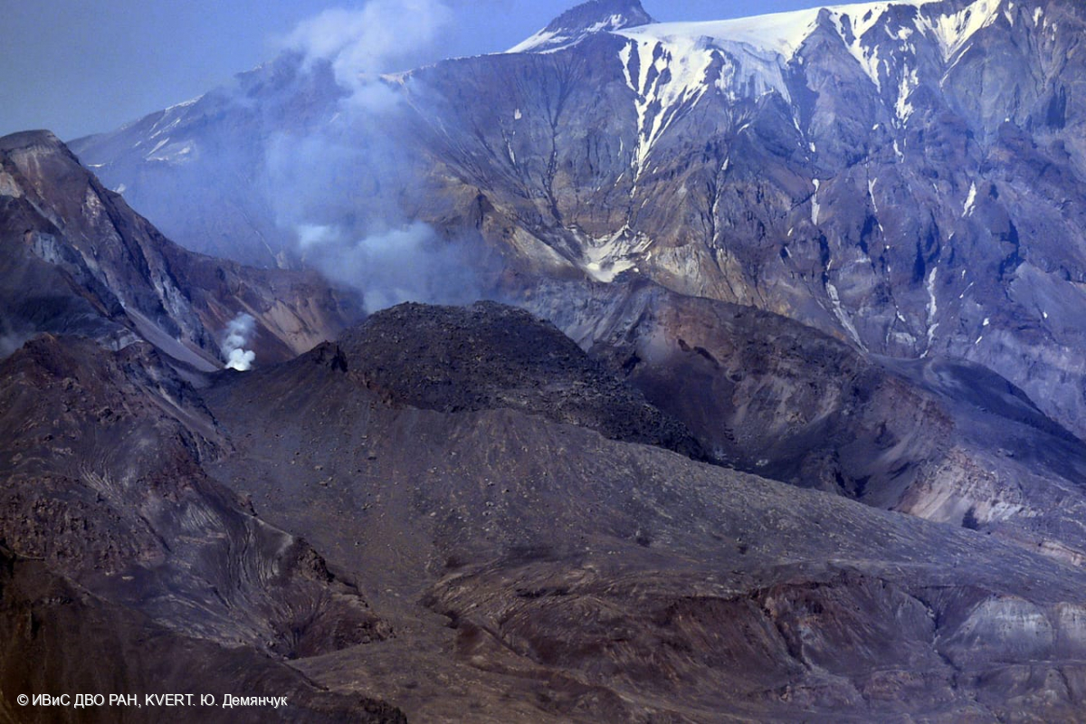
La Réunion , Piton de la Fournaise :
Seismicity
In July 2024, the OVPF-IPGP recorded a total of:
• 23 superficial volcano-tectonic earthquakes (0 to 2.5 km above sea level) under the summit craters;
• 5 deep earthquakes (below sea level);
• 52 long-period earthquakes;
• 307 landslides.
The month of July 2024 was marked by low seismicity under the Piton de la Fournaise with only 23 superficial volcano-tectonic earthquakes and 5 deep earthquakes recorded.
Only 5 superficial volcano-tectonic earthquakes could be located under the Dolomieu crater. The others – of lower magnitudes – could not be located.
Numerous (307) landslides in the Dolomieu Crater, at the Cassé de la Rivière de l’Est and at the Piton de Crac were also recorded.
Deformation
After a resumption in February 2024, the inflation of the building stopped at the beginning of April 2024. A slight deflation of the summit zone was then recorded in April and May. Since then, no significant deformation has been observed.
Balance sheet
Since April 2024, magma replenishment and pressurization of the surface reservoir have ceased.
As of July 2024, seismicity remained low – with only 23 shallow volcano-tectonic earthquakes recorded beneath the summit craters.
Note that since 2016, the replenishment of the superficial magmatic reservoir under the Piton de la Fournaise has taken place in pulses, thus such phases of calm in deformations and seismicity have already been observed on several occasions between 2016 and 2023 over periods ranging from 15 days to several months.
Source et photo : OVPF.
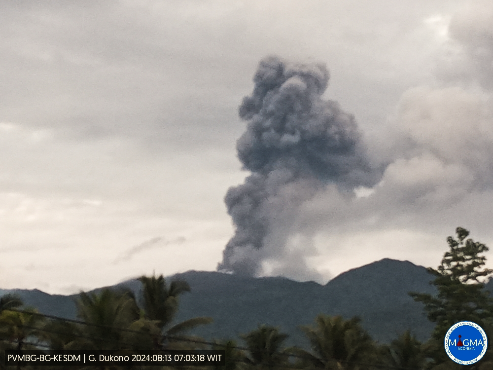
Indonesia , Dukono :
An eruption of Mount Dukono occurred on Tuesday, August 13, 2024 at 07:01 WIT with the height of the ash column observed at ±900 m above the summit (±1987 m above sea level). The ash column was observed to be white to gray in color with thick intensity, oriented towards the West. This eruption was recorded on a seismograph with a maximum amplitude of 34 mm and a duration of 55.57 seconds.
SEISMICITY OBSERVATIONS
87 eruption earthquakes with an amplitude of 7 to 34 mm and a seismic duration of 31.65 to 51.63 seconds.
42 deep tectonic earthquakes with an amplitude of 7 to 34 mm, and an earthquake duration of 60.32 to 115.31 seconds.
1 Continuous tremor with an amplitude of 1 to 8 mm, dominant value of 2 mm.
RECOMMENDATION
(1) People around Mount Dukono and visitors/tourists are advised not to do activities, climb or approach Malupang Warirang Crater within a 3 km radius.
(2) Considering that eruptions with volcanic ash occur periodically and the distribution of ash follows the direction and speed of the wind, so that the landing area of the ash is not fixed, it is recommended that the community around Mount Dukono always wears nose masks. and mouth coverings to use when necessary to avoid the threat of volcanic ash to the respiratory system.
Source et photo : Magma Indonésie.
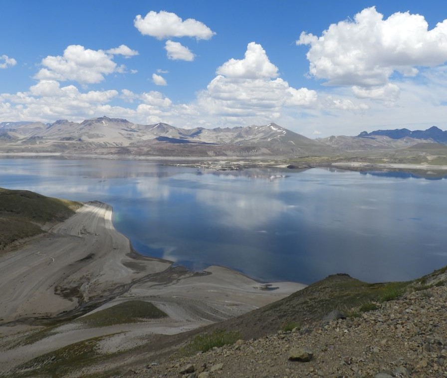
Chile , Laguna del Maule :
Seismology
The seismological activity of the period was characterized by the recording of:
299 seismic events of type VT, associated with the fracturing of rocks (Volcano-Tectonics). The most energetic earthquake had a Local Magnitude (ML) value equal to 2.0, located 4.7 km south-southwest of the center of the lagoon, at a depth of 7 km.
9 LP type seismic events, associated with fluid dynamics inside the volcanic system (Long Period). The size of the largest earthquake evaluated from the Reduced Displacement (RD) parameter was equal to 27.3 cm2.
Fluid geochemistry
No anomalies have been reported in emissions of sulfur dioxide (SO2) into the atmosphere in the area near the volcanic complex, according to data published by the Tropopheric Monitoring Instrument (TROPOMI) and the Ozone Monitoring Instrument (OMI) Sulfur Dioxide Group.
Geodesy
The geodetic activity of the period was characterized by:
– Medium to high magnitude displacement rates in vertical and horizontal components of GNSS equipment, similar to historical averages calculated for the complex.
– Medium to high deformation rates in the monitoring lines, values very similar to those recorded historically.
Consequently, according to the geodetic data obtained during the period, we observe a slight decrease in the movements of the stations compared to the previous period, these quantities being lower than the historical average of the volcanic complex; The maximum rate of change reaches 1.17 cm/month at station MAU2.
Satellite geomorphological analysis
No morphological changes generated by volcanic activity are identified from Planet Scope or Sentinel 2 L2A satellite images.
Analysis of seismic data indicates a state of low energy release due to the appearance of volcano-tectonic activity. The locations of these earthquakes continue to be located mainly in active sources located to the South-West and South-East relative to the center of the lagoon. The volcanic deformation process remains active with rates similar to those observed historically. The above indicates that seismicity is low compared to previous months and the volcanic system continues to show active and stable deformation. As a result, the volcanic technical alert changes to GREEN. This green alert scenario considers the appearance of seismic activity as it has occurred in previous months (swarms and events of magnitude greater than 3.0), deformation, currently stable and continuous, as well as as the permanence of CO2 degassing.
GREEN TECHNICAL ALERT: Active volcano with stable behavior – There is no immediate risk.
Source et photo : Sernageomin
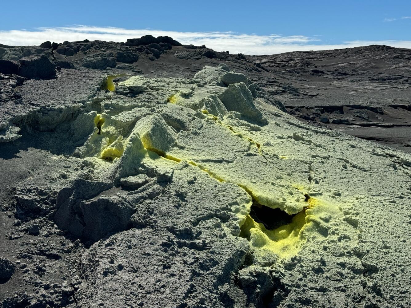
Hawaii , Kilauea :
Monday, August 12, 2024, 9:38 AM HST (Monday, August 12, 2024, 19:38 UTC)
19°25’16 » N 155°17’13 » W,
Summit Elevation 4091 ft (1247 m)
Current Volcano Alert Level: ADVISORY
Current Aviation Color Code: YELLOW
Activity Summary:
Kīlauea is not erupting. Over the past 24 hours, the number of earthquakes detected in the summit, middle East Rift Zone, and upper East Rift Zone remained similar to the previous day. Inflationary ground deformation in the summit and middle East Rift Zone has decreased. New seismic swarms may occur with little or no warning and result in either intrusion of magma or eruption of lava in these regions. There are no significant changes in activity elsewhere on the volcano.
Summit Observations:
Approximately 7 earthquakes were detected beneath Kaluapele (Kīlauea’s summit caldera) over the past 24 hours, at depths of 1–3 km (0.6–1.8 mi) below the ground surface, and with magnitudes of less than M2. Tiltmeters in the summit region (UWE, northwest of the summit, and SDH, southwest of the summit) recorded no significant changes over the past day (1-1.5 microradian of change). GPS instruments around the summit region indicate that gradual inflation has slowed and stabilized. The most recent measurement of the summit’s SO2 emission rate was approximately 64 tonnes per day on August 7, 2024.
Rift Zone Observations:
The reduced rate of seismicity beneath the upper East Rift Zone (UERZ) since August 8 continues, with approximately 3 earthquakes detected over the past 24 hours (compared to 6 over the previous day), at depths of 1–5 km (0.6–3 mi) below the ground surface, and with magnitudes of less than M2. This is a notable change compared to the week before August 8, when more than 50-100 earthquakes were occurring per day beneath the UERZ following the intrusion on July 22-25. The ESC tiltmeter in the UERZ recorded no significant changes.
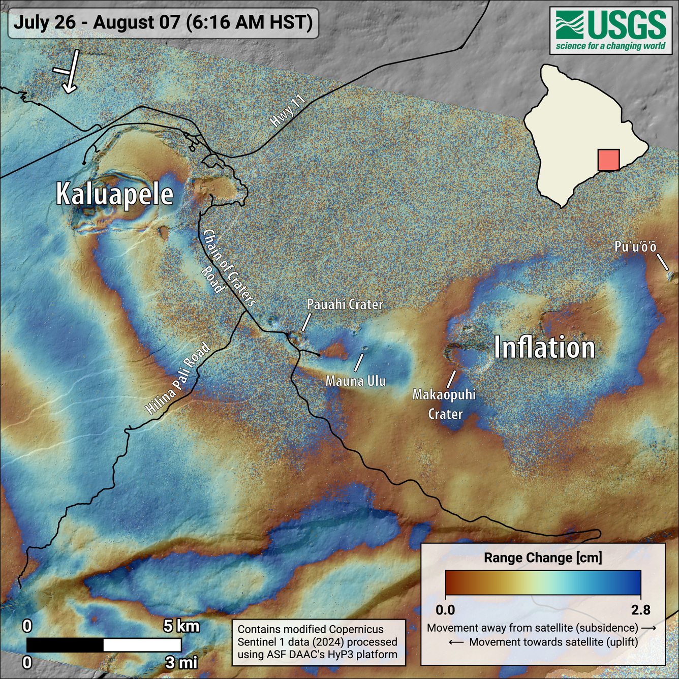
This map shows recent deformation at Kīlauea, over the timeframe of July 26-August 7, 2024. Data were acquired by the European Space Agency’s Sentinel-1A satellite. Colored fringes denote areas of ground deformation, with more fringes indicating more deformation. Each color cycle represents 2.8 cm (1.1 in) of ground motion. The round feature east of Makaopuhi Crater on the East Rift Zone indicates inflation over this time period due to magma accumulation underground. Arrow in the upper left indicates satellite orbit direction (arrow) and look direction (bar).
The rate of seismicity beneath the middle East Rift Zone (MERZ) near Makaopuhi Crater and Napau Crater in Hawaiʻi Volcanoes National Park has decreased since August 3. About 18 earthquakes were detected over the past day (compared to 9 the day before), at depths of 1–5 km (0.6–3 mi) below the ground surface, and with magnitudes of M2 or less. The rate of inflationary ground deformation in the MERZ has also decreased over the past week. The POC tiltmeter, located on the north flank of Puʻuʻōʻō, continued to record motions consistent with MERZ inflation but at a notably lower rate than on August 8-10 (about 1.5 microradians over the past 24 hours, compared to 1.5 microradians over the previous day, and 7 microradians on August 9). Ground deformation signals recorded by POC and nearby GPS stations indicate the center of deformation remains west of Puʻuʻōʻō. HVO released an Information Statement on August 8 summarizing recent activity, interpretations, and possible scenarios associated with recent activity in the MERZ.
Measurements from continuous gas monitoring stations downwind of Puʻuʻōʻō in the middle East Rift Zone—the site of 1983–2018 eruptive activity—remain below detection limits for SO2, indicating that SO2 emissions from this area are negligible.
Rates of seismicity and ground deformation beneath the lower East Rift Zone and Southwest Rift Zone remain low.
Source : HVO
Photos : USGS / M. Patrick.