July 16 , 2024.
Italy / Sicily , Etna :
Press release on the activity of Etna, July 15, 2024, 9:34 p.m. (19:34 UTC).
The National Institute of Geophysics and Volcanology, Osservatorio Etneo, communicates that from the analysis of images from surveillance cameras, from around 7:00 p.m. UTC, a progressive increase in Strombolian activity in the Voragine crater was observed. The forecast model on the dispersion of the eruptive cloud produced by the current activity indicates a South-South-East direction.
The average amplitude of the volcanic tremor continues to present an increase in values and has currently reached a very high level. The center of gravity of the sources of volcanic tremors is located to the east of the Voragine crater, at an altitude of approximately 3,000 m above sea level. Along with the increase in tremor, there is a new increase in infrasound activity, localized at the Voragine crater.
Regarding deformations, we are currently seeing a variation in the inclinometer signal from the PDN summit station of 0.1 microradians; the drilling dilatometer at the DRUV station was already starting to show a slight decompression from 17:00 UTC.
Press release on the activity of Etna, July 15, 2024, 9:57 p.m. (19:57 UTC).
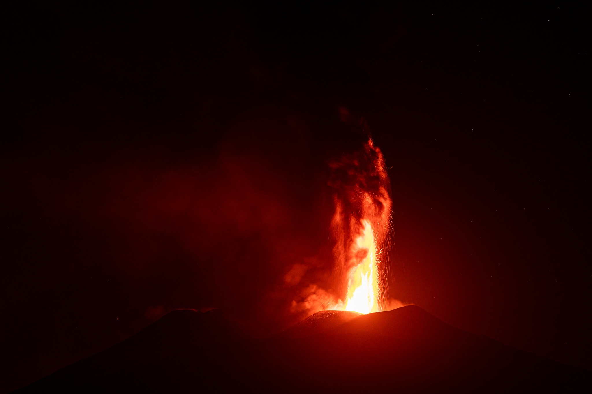
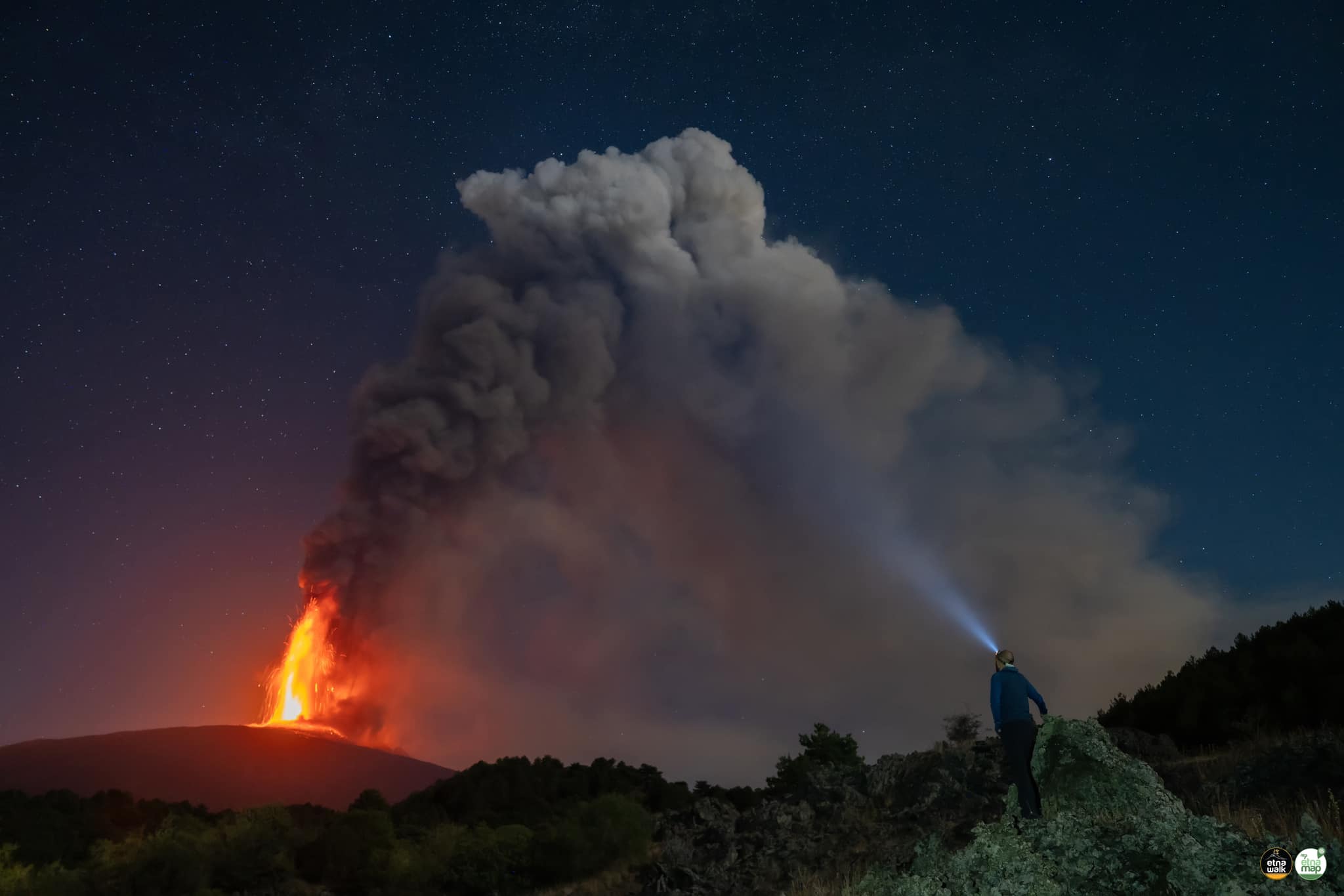
The National Institute of Geophysics and Volcanology, Osservatorio Etneo, communicates that from the analysis of images from the surveillance camera network, it is possible to observe that the Strombolian activity in the Voragine crater has further intensified and a lava fountain is currently underway. This activity produces ash emissions which, in accordance with the forecast model, disperse in the South-South-East direction.
The average amplitude of the volcanic tremor continues to show a further increase, with very high values. The centroid of volcanic tremor sources continues to be located just east of the Voragine crater, at an altitude of approximately 2,900 to 3,000 m above sea level. Infrasound activity also records a new increase and is still located at the Voragine crater.
Regarding deformations, the variation of the inclinometer signal at the PDN summit station continues and has reached 0.25 microradians; the decompression trend continues at the DRUV station drilling dilatometer which began at 17:00 UTC.
Press release on the activity of Etna, July 16, 2024, 00:39 (22:39 UTC).
The National Institute of Geophysics and Volcanology, Osservatorio Etneo, communicates that according to the analysis of the INGV-OE surveillance cameras, it is observed that the activity of the lava fountains of the Voragine crater, which began at 19: 54 UTC and which is still ongoing, produced an eruptive column at approximately 6000 m altitude above sea level which is propagating eastwards with ash fallout reported in the towns of Viagrande and Acicastello.
The activity also produced a lava flow that overflowed the northwest rim of the Bocca Nuova crater, with the front reaching an altitude of approximately 3,000 m above sea level.
The average amplitude of the volcanic tremor remains at very high levels. The centroid of volcanic tremor sources is located just east of the Voragine crater, at an altitude of approximately 2,800 m above sea level. The frequency of occurrence of infrasound events decreases. The infrasound events are located in the Voragine crater and the amplitude of the events is high.
Ground deformation analyzes reveal a cumulative decompression of approximately 100 nanostrains, measured by the Monte Ruvolo dilatometer from approximately 19:00 UTC to 22:00 UTC. The stations in the inclinometer network present variations in inclination of the order of a tenth of a microradian.
Press release on the activity of Etna, July 16, 2024, 06:19 (04:19 UTC).
The National Institute of Geophysics and Volcanology, Osservatorio Etneo, communicates that according to the analysis of surveillance cameras, it was observed that the activity of the lava fountains of the Voragine crater gradually dried up and then stopped around 00:10 UTC, maintaining modest Strombolian activity until around 03:00 UTC. Concerning the lava flow produced during the fountain event and reported in the previous press release, it still appears weakly fed. From a seismic point of view, the average amplitude of the volcanic tremor, after reaching the maximum values yesterday between 7:40 p.m. and 11:00 p.m. UTC, then showed a downward trend and around 03:30 a.m. UTC it reached the range of average values, where they live. The sources of the tremor are confined to the summit craters area at an altitude of approximately 3,000 m above sea level. Infrasound activity is weak, with events mainly localized to the Southeast Crater. Concerning ground deformations, no significant changes were recorded from 00:00 UTC.
Further updates will be communicated shortly
Source : INGV
Photos : Guide Alpine Vulcanologiche Etna (15/07/2024) , Etna Walk (15/07/2024) .
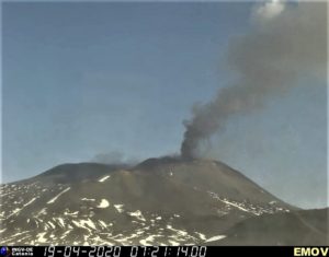
Russia / Kuril Islands , Ebeko :
VOLCANO OBSERVATORY NOTICE FOR AVIATION (VONA)
Issued: July 15 , 2024
Volcano: Ebeko (CAVW #290380)
Current aviation colour code: ORANGE
Previous aviation colour code: orange
Source: KVERT
Notice Number: 2024-39
Volcano Location: N 50 deg 41 min E 156 deg 0 min
Area: Northern Kuriles, Russia
Summit Elevation: 1156 m (3791.68 ft)
Volcanic Activity Summary:
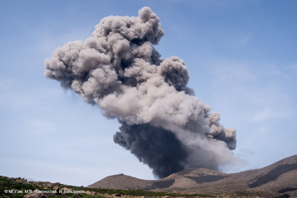
A moderate explosive eruption of the volcano continues. According to visual data from Severo-Kurilsk, an explosion sent ash up to 2 km a.s.l., and ash cloud drifted to the east of the volcano.
A moderate explosive eruption of the volcano continues. Ash explosions up to 6 km (19,700 ft) a.s.l. could occur at any time. Ongoing activity could affect low-flying aircraft and airport of Severo-Kurilsk.
Volcanic cloud height:
2000 m (6560 ft) AMSL Time and method of ash plume/cloud height determination: 20240715/2218Z – Visual data
Other volcanic cloud information:
Distance of ash plume/cloud of the volcano: 3 km (2 mi)
Direction of drift of ash plume/cloud of the volcano: E / azimuth 95 deg
Time and method of ash plume/cloud determination: 20240715/2218Z – Visual data
Source : Kvert.
Photo : I. Bolshakov. M.V. Lomonosov MGU ( archive 07/2023 ).
New Zealand , White Island :
Moderate emission of steam and volcanic gas, with minor ash at Whakaari/White Island.
Volcanic Alert Level remains at Level 2 and Aviation Colour Code remains Yellow. Published: Tue Jul 16 2024 10:00 AM
Due to good weather for observations since Wednesday 10th July we have observed a continuous moderate gas and steam plume rising from Whakaari/White Island. The plume is being emitted from an enlarged vent on the crater floor. Minor amounts of ash were observed intermittently in the vent during a gas flight, but this is not considered to constitute new eruptive activity. The Volcanic Alert Level remains at Level 2 (moderate to heightened unrest) and the Aviation Colour Code remains Yellow.
Analysis of data collected during a gas flight on Friday (July 12th) indicated decreased levels of magmatic gas compared to our previous observations on June 10th. Although gas emission is lower it remains at moderate levels compared to what was observed before May. The crater lake has almost disappeared with only a few small puddles remaining. Gas and steam is now exiting from an enlarged vent on the crater floor. We did not observe any eruptions, but a minor amount of ash was intermittently seen in the vent. This is likely caused by some erosion inside the vent due to the vigorous degassing. These kinds of changes in the vent area and the plume have been seen many times in the past and represent normal processes at the volcano. No ash was observed in the plume outside of the crater.
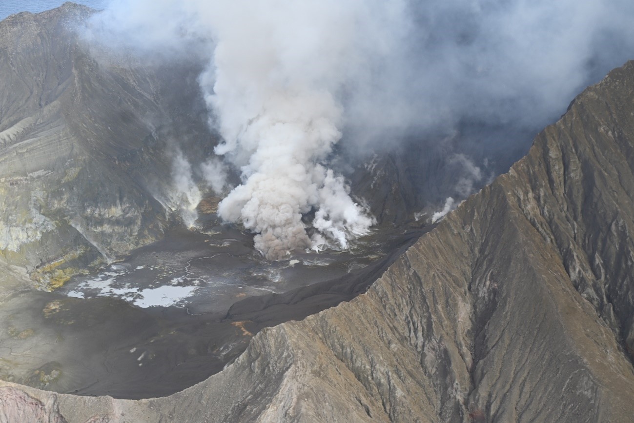
Figure 1. This image captured on Friday (July 12th) shows a plume of gas and steam emitting from a vent. Minor amounts of brown non-eruptive ash can also be seen near the vent at the base of the plume.
Although the Volcanic Alert Level remains at Level 2, eruptions can still occur with little or no warning. The Volcanic Alert Level reflects the current level of volcanic unrest or activity and is not a forecast of future activity. While Volcanic Alert Level 2 is mostly associated with volcanic unrest hazards (including discharge of steam and hot volcanic gases, earthquakes, landslides, and hydrothermal activity), the potential for eruption hazards remains.
As we have no sensors on the island, we continue to rely on remote cameras and satellite imagery, complemented with gas and observation flights to assess the volcanic activity. Further gas and observation flights will be conducted by GNS Science volcanologists to maintain a close eye on activity levels.
Source : Geonet / Oliver Lamb/ Duty Volcanologist .
Photo : Geonet ( 12/07/2024).
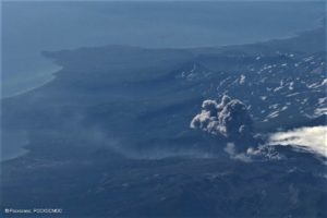
Indonesia , Lewotobi Laki-laki :
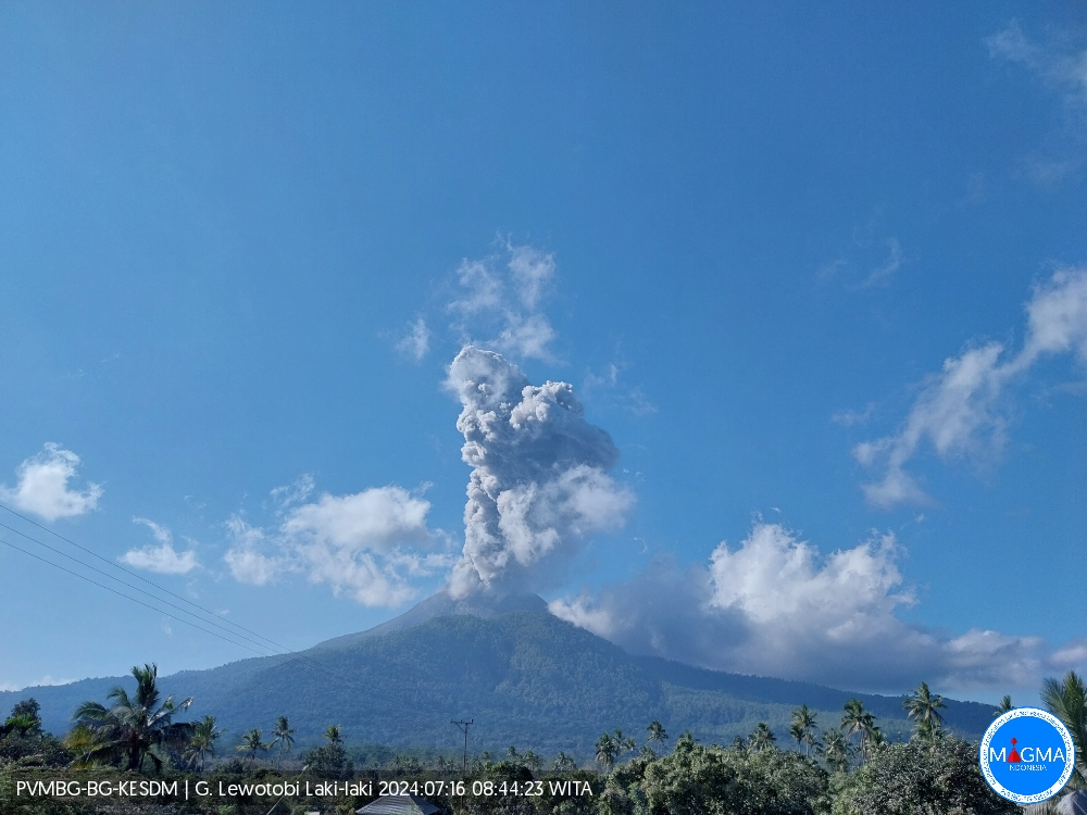
An eruption of Lewotobi Laki-laki occurred on Tuesday July 16, 2024 at 08:41 WITA with the height of the ash column observed at ± 800 m above the summit (± 2384 m above sea level) . The ash column was observed to be gray with thick intensity, oriented towards the South-West and West. This eruption was recorded on a seismograph with a maximum amplitude of 37 mm and a duration of 303 seconds.
VOLCANO OBSERVATORY NOTICE FOR AVIATION – VONA
Issued : July 16 , 2024
Volcano : Lewotobi Laki-laki (264180)
Current Aviation Colour Code : ORANGE
Previous Aviation Colour Code : orange
Source : Lewotobi Laki-laki Volcano Observatory
Notice Number : 2024LWK235
Volcano Location : S 08 deg 32 min 20 sec E 122 deg 46 min 06 sec
Area : East Nusa Tenggara, Indonesia
Summit Elevation : 5069 FT (1584 M)
Volcanic Activity Summary :
Eruption with volcanic ash cloud at 00h41 UTC (08h41 local).
Volcanic Cloud Height :
Best estimate of ash-cloud top is around 7629 FT (2384 M) above sea level or 2560 FT (800 M) above summit. May be higher than what can be observed clearly. Source of height data: ground observer.
Other Volcanic Cloud Information :
Ash cloud moving from southwest to west. Volcanic ash is observed to be gray. The intensity of volcanic ash is observed to be thick.
Remarks :
Eruption recorded on seismogram with maximum amplitude 37 mm and maximum duration 303 second.
Source et photo : Magma Indonésie .
Hawaii , Kilauea :
Monday, July 15, 2024, 8:14 AM HST (Monday, July 15, 2024, 18:14 UTC)
19°25’16 » N 155°17’13 » W,
Summit Elevation 4091 ft (1247 m)
Current Volcano Alert Level: ADVISORY
Current Aviation Color Code: YELLOW
Activity Summary:
No significant change; Kīlauea volcano is not erupting. A minor increase in earthquake activity has been observed beneath the summit and the Upper East Rift Zone over the past 24 hours. Gradual inflation of the summit and upper rift zones continues. Substantial increases in seismicity and/or deformation could result in a new eruptive episode, but presently there are no signs of imminent eruption.
Summit and Upper Rift Zone Observations:
Over the past 24 hours, there were approximately 42 earthquakes detected beneath Kaluapele (Kīlauea caldera) and 38 earthquakes detected beneath the upper East Rift Zone, mostly at depths of 0–2 km (0.0–1.2 mi) beneath the ground surface. A minor increase in earthquake counts has been observed beneath Kaluapele and the upper East Rift Zone compared to the previous day (during which there were 27 events detected beneath the summit and 40 events detected beneath the upper East Rift Zone). All earthquake counts are well below the counts recorded during the June 27–July 1 upper East Rift Zone swarm. All events were smaller than M3. Tiltmeters in Kīlauea summit region (instruments SDH, southwest of the summit, and UWE, northwest of the summit) show longer-term increases in inflationary ground deformation rates over the past day, as well as more minor short-term variations in tilt. GPS instruments around the summit region continue to show longer-term, gradual inflation since the end of the June 3, 2024, eruption. The most recent measurement of the summit’s SO2 emission rate was approximately 61 tonnes per day on July 9, 2024.
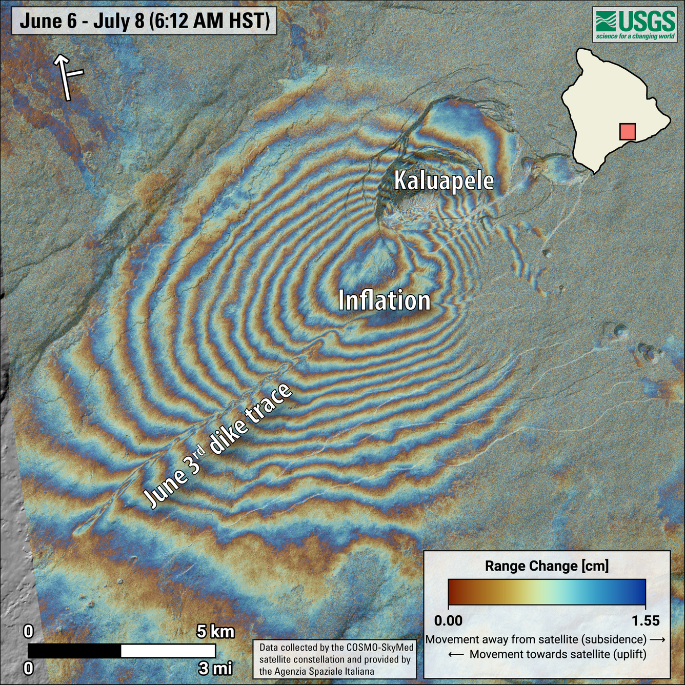
This map shows recent deformation at Kīlauea, over the timeframe of June 6 to July 8, 2024. Data was recorded by the Italian Space Agency’s (ASI) Cosmo-SkyMED satellite. Colored fringes denote areas of ground deformation, with more fringes indicating more deformation. Each color cycle represents 1.5 cm (0.6 in) of ground motion. The bullseye feature indicates inflation of the area southwest of Kaluapele over this time period. The northeast-southwest trending line-like feature reflects the intrusion (body of magma underground) that fed the June 3, 2024, eruption. Arrow in the upper left indicates satellite orbit direction (arrow) and look direction (bar).
Middle and Lower Rift Zone Observations:
Rates of seismicity and ground deformation beneath the middle and lower East Rift Zone and lower Southwest Rift Zone remain low. Recent eruptive activity and ongoing unrest have been restricted to the summit and upper rift zone regions. Measurements from continuous gas monitoring stations downwind of Puʻuʻōʻō in the middle East Rift Zone—the site of 1983–2018 eruptive activity—remain below detection limits for SO2, indicating that SO2 emissions from Puʻuʻōʻō are negligible.
Source et photo : HVO