September 02 , 2019.
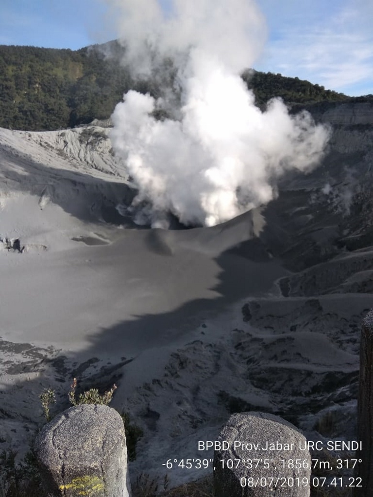
Indonesia , Tangkuban Parahu :
Level of activity at Level II (WASPADA). G. Tangkuban Parahu (2084 m above sea level) erupted on July 26, 2019 at 3:48 pm: 18 Western Indonesia time with a column of ash rising to within ± 200 m from the summit (± 2284 m above sea level). Following another eruption on August 1, 2019, at 20:46, western time of Indonesia, the smoke column was 180 m above the crater floor, followed by an eruption on August 2, 2019. from 00:43 am and another eruption at 04:56 local time from western Indonesia.
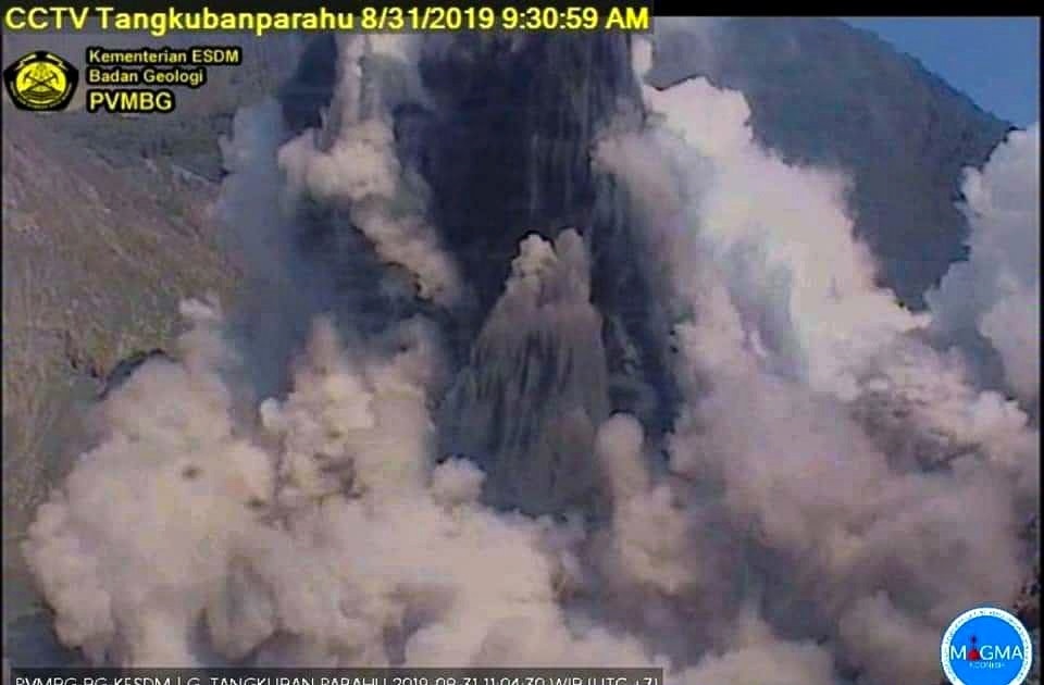
An eruption occurred on August 31, 2019 at 09:30 WIB with a column of ash high of ± 150 meters from the bottom of the crater.
Since yesterday and until this morning, the volcano was clearly visible. The smoke from the crater is observed at medium to moderate pressure, white in color, and 180 meters high from the bottom of the crater.
The seismographs, on September 1st, 2019, recorded:
Tremor continuous amplitude of 10 to 50 mm, dominant value of 30 mm.
Recommendation:
Communities around Mount Tangkuban Parahu and visitors / tourists / mountaineers should not approach the Raku Crater at the top of Mount Tangkuban Parahu within 1.5 km of the active crater. It is recommended to temporarily close the Tangkuban Parahu Nature Park for a greater safety distance.
Source : PVMBG.
Photos : PVMBG , BPBD.
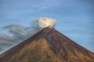
Mexico , Popocatepetl :
September 1st, 11:30 am (September 1st, 4:30 pm GMT)
During the last 24 hours, thanks to the surveillance systems of the Popocatépetl volcano, 319 exhalations have been identified, accompanied by water vapor, gas and ash, with a maximum height of 1.2 km and a direction of propagation towards the North-west . 277 minutes of low amplitude tremor were also recorded. In addition, 5 minor explosions were recorded, accompanied by columns of ash less than 2 km high, the largest recorded at 20:41 yesterday. Incandescent fragments were observed within 100 m of the crater.
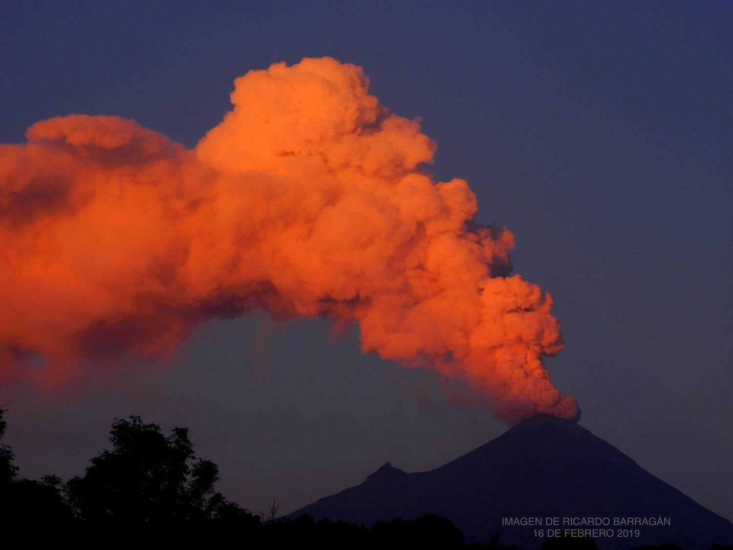
Derived from the activity of this period, light falls of ash were reported in the municipalities of Atlautla, Ozumba, Juchitepec and Tenango del Aire, in the State of Mexico.
Today and at the time of this report, the volcano is observed with emissions of volcanic gases and ash that are dispersed towards the North-West.
CENAPRED urges NOT to approach the volcano and in particular the crater because of the risk of falling ballistic fragments, and in case of heavy rains to stay away from the bottom of the ravines due to the risk of mudslides and debris.
The warning light of Popocatépetl is in YELLOW PHASE 2.
Source : Cenapred.
Photo : Ricardo Barragan.
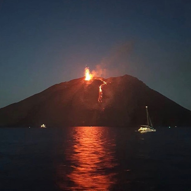
Italy , Stromboli :
Daily Bulletin of 01/09/2019
VOLCANOLOGICAL OBSERVATIONS
The eruptive activity of Stromboli was characterized by the analysis of thermal and visible images recorded by the cameras located at 400 meters, Punta dei Corvi and at 190 meters of altitude. Data recorded over the last 24 hours indicate that the explosive activity has affected the two North and Central-South zones of the crater terrace. The average total occurrence frequency of explosions was about 32 events / hour (variability of 3.8 events / hour), with a moderate transient increase in the frequency and intensity of occurrence of explosions between 02: 00 UTC and 04:00 UTC in the North and South-Central zones.
In conclusion, the observations indicate that the explosive activity was at a medium level compared to the ordinary characteristics of Stromboli.
SEISMOLOGY
The bulletin is established with data acquired from a maximum of 7 stations. The seismic activity recorded during the last 24 hours has the following characteristics: No seismic signal associated with a landslide has been recorded.
Very long period (VLP) event counting provides an average of about 29 events / hour.
The magnitude of the VLP events showed a decrease in amplitude towards generally low values. The amplitude of the explosion earthquakes showed generally low values. The amplitude of the volcanic tremor, estimated at the summit station STR1, generally had mean-low values.
Source : INGV Vulcani.
Lire l’article en entier : file:///C:/Users/Utilisateur/AppData/Local/Packages/Microsoft.MicrosoftEdge_8wekyb3d8bbwe/TempState/Downloads/BollettinoGiornalieroStromboli20190901%20(1).pdf
Photo : Peppe Caridi /meteoweb.
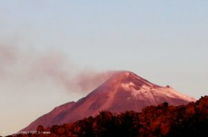
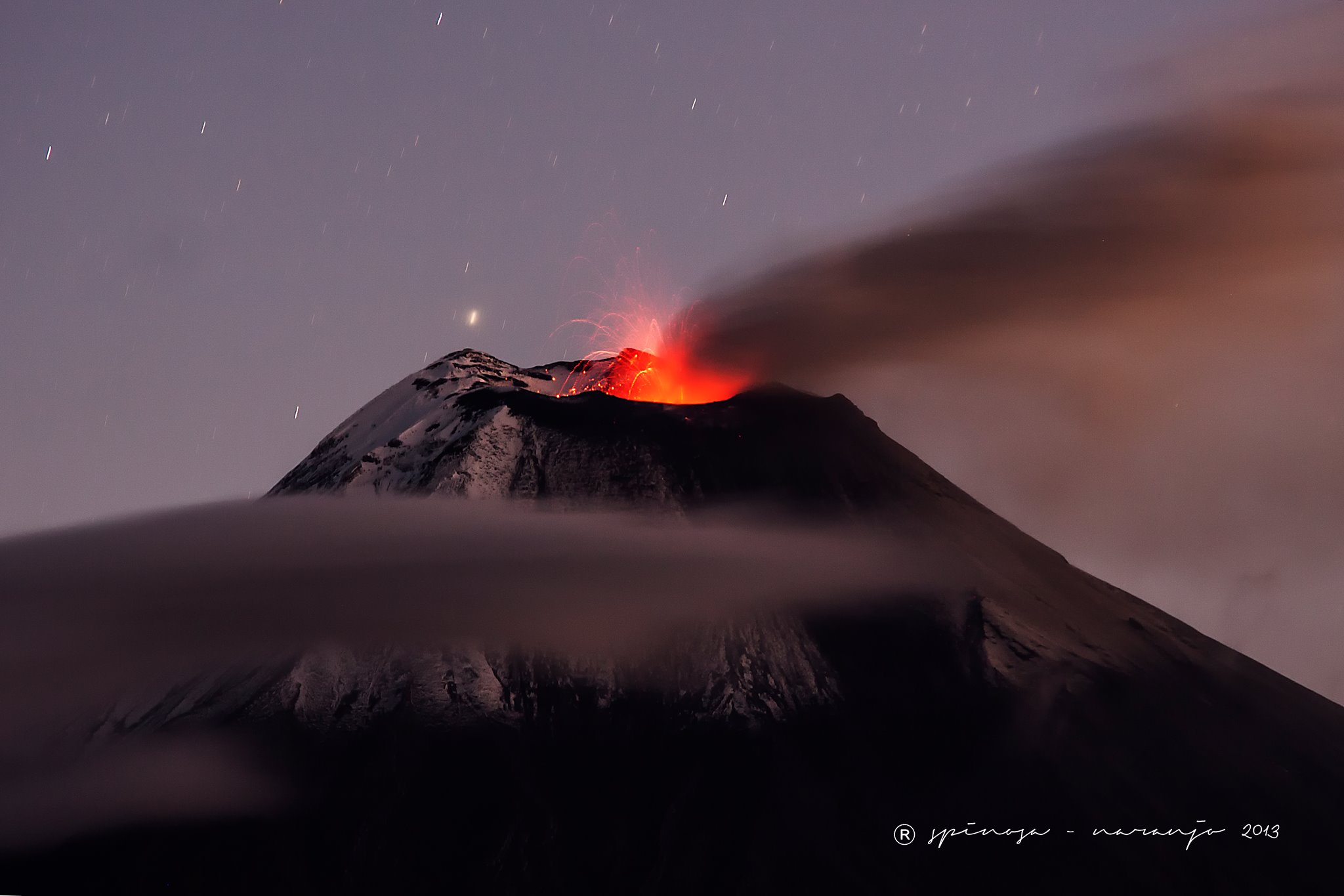
Ecuador , Reventador :
DAILY REPORT OF THE STATE OF THE VOLCANO REVENTADOR, SUNDAY SEPTEMBER 1, 2019.
Information Geophysical Institute – EPN
Level of surface activity: high
Superficial trend: no change
Internal activity level: high
Internal trend: no change.
Seismicity (events):
From 31 August 2019, 11:00 to 01 September 2019, 11:00
Events of type Long Period (LP): 46
Explosions (EXP): 24
Tremor of emission (TE): 4
Harmonic tremor (TA): 1
Rain / lahars: There were no rains in the area.
Emission / Ash Column: During the evening of yesterday and this morning, different ash emissions were observed, with an altitude sometimes exceeding 600 m above the crater and heading north and west.
Other monitoring parameters: No change.
Observations: Currently, the volcano is covered.
Alert level: orange.
Source : IGEPN.
Photo : J L Espinosa Naranjo , 2013.
Alaska , Cleveland :
52°49’20 » N 169°56’42 » W,
Summit Elevation 5676 ft (1730 m)
Current Volcano Alert Level: ADVISORY
Current Aviation Color Code: YELLOW
Nothing noteworthy observed in cloudy satellite images over the past day. Nothing significant was detected in seismic data and no activity was recorded by regional or local infrasound arrays during the last 24 hours.
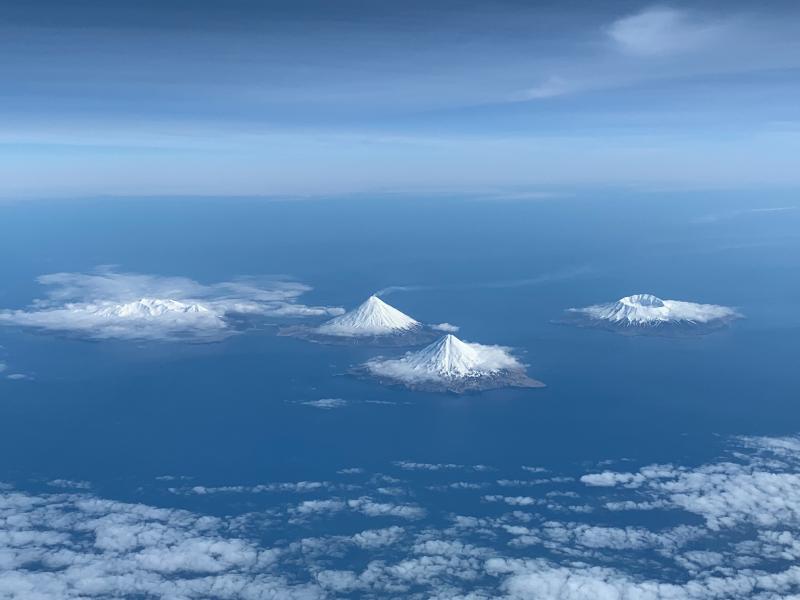
Photo, April 27, 2019, looking south at some of the Islands of Four Mountains volcanoes. Volcanoes from left to right: Kagamil, Cleveland, Carlile, Herbert.
Episodes of lava effusion and explosions can occur without advance warning. Explosions from Cleveland are normally short duration and only present a hazard to aviation in the immediate vicinity of the volcano. Larger explosions that present a more widespread hazard to aviation are possible, but are less likely and occur less frequently.
Cleveland volcano is monitored by only two seismic stations, which restricts AVO’s ability to detect precursory unrest that may lead to an explosive eruption. Rapid detection of an ash-producing eruption may be possible using a combination of seismic, infrasound, lightning, and satellite data.
Source : AVO.
Photo: Dave Clum.