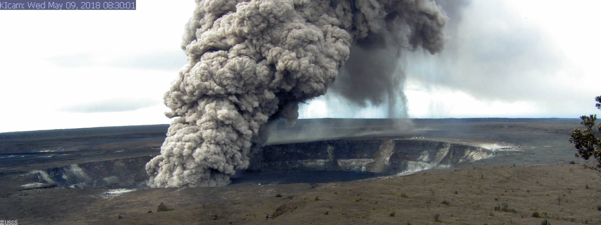
May 10 , 2018. EN . Pu’u ‘Ō’ō / Kilauea , Copahue , Piton de la Fournaise , Sangeangapi .

May 10 , 2018.


Pu’u ‘Ō’ō / Kilauea , Hawai :

Eruption update:
Hawaiian Volcano Observatory confirms 2 new vents. Vent number 13 has opened near the intersection of Leilani Avenue and Kahukai Road and Vent number 14 near Kaupili St. and Leilani Avenue. Both have paused but continue to release hazardous gases. Since the onset of this eruption, a total of 14 fissures have emerged. The lava has covered 104 acres and 36 structures have been destroyed.


Tuesday, May 8, 2018, 11:18 PM HST (Wednesday, May 9, 2018, 09:18 UTC)

19°25’16 » N 155°17’13 » W,
Summit : 4091 ft (1247 m)
Current Volcano Alert Level: WARNING
Current Aviation Color Code: ORANGE

Lower East Rift Zone Eruption :
The intermittent eruption of lava in Leilani Estates in the lower East Rift Zone of Kīlauea Volcano continues. Activity today was focused on the northeast portion of the fissure area; two new fissure segments (13 and 14) broke ground between fissures 7 and 6. Fissure 13 cut across Leilani Street. By 5:00 pm, fissures 13 and 14 were inactive; late this evening geologists reported loud jetting and booming sounds, and some spattering, at fissure 13. At about 6:00 p.m. reports of booming sounds were reported in the vicinity of Black Sands Beach Subdivision. When HVO geologists arrived soon after, no such sounds were occurring.

Earlier this morning, geologists reported the widening of cracks of about 1 to 4 cm (0.4 to 1.6 in) of cracks on Highway 130 and Ali’ili road.

Rates of seismicity changed little throughout the day, but increased during the fissure activity in the afternoon. Gas emissions remain elevated in the vicinity of fissures.

HVO field crews successfully completed the installation of two new co-located seismometers and GPS receivers on the north and south sides of the East Rift Zone. Mahalo to landowners for allowing access and use of their property. HVO geologists will be in the area overnight to track and report to Hawaii County Civil Defense on the activity, and other scientists are tracking the volcano’s overall activity 24/7 using various monitoring data streams.

This map shows the locations of fissures and an ‘a’ā flow erupted since May 3 in the order that they occurred in Leilani Estates as of 5:30 p.m. HST, May 9. Note the area of heavy steaming from ground cracks that began earlier this afternoon, located west of Highway 130. The purple areas are lava flows erupted in 1840, 1955, 1960, and 2014-2015.

HVO/USGS Volcanic Activity Notice

Current Volcano Alert Level: WARNING
Current Aviation Color Code: ORANGE

Issued: Wednesday, May 9, 2018, 8:02 AM HST
Source: Hawaiian Volcano Observatory
Location: N 19 deg 25 min W 155 deg 17 min
Elevation: 4091 ft (1247 m)
Area: Hawaii

Volcanic Activity Summary:
The steady lowering of the lava lake in « Overlook crater » within Halemaʻumaʻu at the summit of Kīlauea Volcano has raised the potential for explosive eruptions in the coming weeks. If the lava column drops to the level of groundwater beneath Kīlauea Caldera, influx of water into the conduit could cause steam-driven explosions. Debris expelled during such explosions could impact the area surrounding Halemaʻumaʻu and the Kīlauea summit. At this time, we cannot say with certainty that explosive activity will occur, how large the explosions could be, or how long such explosive activity could continue.
Residents of the Kīlauea summit area should learn about the hazards of ashfall, stay informed of the status of the volcano and area closures, and review family and business emergency plans.

Remarks: HAZARDS
Primary hazards of concern should this activity occur are ballistic projectiles and ashfall.

BALLISTIC PROJECTILES
During steam-driven explosions, ballistic blocks up to 2 m (yards) across could be thrown in all directions to a distance of 1 km (0.6 miles) or more. These blocks could weigh a few kilograms (pounds) to several tons.
Smaller (pebble-size) rocks could be sent several kilometers (miles) from Halemaʻumaʻu, mostly in a downwind direction.

ASHFALL
Presently, during the drawdown of the lava column, rockfalls from the steep enclosing walls of the Overlook crater vent impact the lake and produce small ash clouds. These clouds are very dilute and result in dustings of ash (particles smaller than 2 mm) downwind.

Should steam-driven explosions begin, ash clouds will rise to greater elevations above ground. Minor ashfall could occur over much wider areas, even up to several tens of miles from Halemaʻumaʻu. In 1924, ash may have reached as high as 20,000 feet above sea level. Small amounts of fine ash from these explosions fell over a wide area as far north as North Hilo (Hakalau), in lower Puna, and as far south as Waiohinu.

Ash column rises from the Overlook crater at the summit of Kīlauea Volcano. HVO’s interpretation is that the explosion was triggered by a rockfall from the steep walls of Overlook crater. The photograph was taken at 8:29 a.m. HST from the Jaggar Museum overlook. The explosion was short-lived. Geologists examining the ash deposits on the rim of Halema‘uma‘u crater found fresh lava fragments hurled from the lava lake. This explosion was not caused by the interaction of the lava lake with the water table. When the ash cleared from the crater about an hour after the explosion, geologists were able to observe the lava lake surface, which is still above the water table.


GAS
Gas emitted during steam-drive explosions will be mainly steam, but will include some sulfur dioxide (SO2) as well. Currently, SO2 emissions remain elevated.

WARNING TIME
Steam-driven explosions at volcanoes typically provide very little warning. Once the lava level reaches the groundwater elevation, onset of continuous ashy plumes or a sequence of violent steam-driven explosions may be the first sign that activity of concern has commenced.

BACKGROUND
Kīlauea’s lava lake began to drop on May 2, 2018. From its peak on May 2 to the most recent measurement at 9 pm on May 6, the lava lake surface dropped a total of more than 200 m (656 ft). The subsidence was at a relatively constant rate of about 2 meters (yards) per hour.

Measurements of subsidence have not been possible since May 6 because of thick fume and the increasing depth to the lava surface. However, thermal images indicate continued lowering of the lake surface since that time, consistent with deflationary tilt recorded at Kīlauea’s summit. Therefore, we infer that the lake surface continues to drop at roughly the same rate. So, while HVO cannot report exact depths of the receding lava lake, we can monitor the overall trend.

USGS and HVO scientists are monitoring changes at the summit 24/7 and watching for signs that hazardous conditions have increased, or may increase. HVO is working closely with Hawai’i Volcanoes National Park and Hawai’i County Civil Defense to respond to this situation.

Wednesday, May 9, 2018, 4:55 PM HST (Thursday, May 10, 2018, 02:55 UTC)

Lower East Rift Zone Eruption
The intermittent eruption of lava in Leilani Estates in the lower East Rift Zone of Kīlauea Volcano continues. Visible activity this early afternoon was again focused on the northeast portion of the fissure area. Fissure 15 broke ground across Poihiki Road, generating a pahoehoe flow about 20 m (66 ft) long. During an overflight of the area about 3 p.m. HST, geologists observed a new steaming area uprift (west) of Highway 130. During a second overflight at 4:30 p.m., the area was still steaming.

Rates of motion increased late this morning on a GPS station 1.5 km (1 mile) southeast of Nanawale Estates. The direction of motion is consistent with renewed movement of magma in the downrift direction (to the northeast).

Rates of seismicity changed little throughout the day; located earthquakes were mostly uprift (west) of Highway 130. Gas emissions remain elevated in the vicinity of fissures.

Kīlauea Volcano Summit
Tiltmeters at the summit of Kīlauea Volcano continue to record the deflationary trend of the past week and the lava lake level continues to drop. At about 8:32 a.m. HST, a large rockfall from the steep crater walls into the retreating lake triggered an explosion that generated an ash column above the crater; the ash was blown toward the south-southwest. Rockfalls and explosions that produce ash columns are expected to continue.

A 3D model of the Overlook crater was created from thermal images collected during an early afternoon helicopter overflight on May 8. Based on the 3D model, the lake level was about 295 m (970 feet) below the floor of Halema’uma’u Crater.

Earthquake activity in the summit remains elevated. Many of these earthquakes are related to the ongoing subsidence of the summit area and earthquakes beneath the south flank of the volcano.

Source : HVO.

Photos : HVO. Hawai news now .

Vidéo : HVO / Big Island Vidéo news.


Copahue , Chile :

During the reporting period, 96 seismic events classified as volcano tectonic (VT) associated with fracturing processes of rigid materials were recorded. The highest energy event had a local magnitude (ML) equal to 2.6 and was located 11.8 km in the northeast direction (NE) of the active crater El Agrio, at a depth of approximately 1 km.
Similarly 378 earthquakes associated with earthquakes related to fluid dynamics inside the volcano were recorded, cataloged as long period (LP) events, with a reduced displacement value (RDC) of up to 4, 4 cm2.
The series of bottom tremors at the Copahue reference station (2 km distance from the El Agrio crater) showed fluctuating trends between 0.6 and 3.4 cm 2 of reduced displacement (DRC), respectively considered low  to moderate values, always with a dominant frequency band between 0.8 and 3.4 Hz.
IP cameras installed in the vicinity of the volcano recorded a constant degassing of the active crater (El Agrio) with a maximum height of 600 m (18 April). In addition, it is pointed out that since the early morning of April 23 there has been a steady glow in the crater El Agrio, a phenomenon that has not been recorded since January of this year.

From the data obtained from geodetic monitoring stations, we observed during the last month a stability of the deformation recorded similar to the values ​​observed during the previous months.
According to data published by the Sulfur Dioxide (OMI) Ozone Monitoring Group, no sulfur dioxide (S02) emissions have been reported to the atmosphere in the area adjacent to the volcanic building (http: // www. http://so2.gsfc.nasa.gov/) and the National Environmental Satellite Information and Data Service (NESDIS) (http://sateDsanoine.nesdis.noaa.gov).
No thermal warnings were reported in the area associated with the volcanic structure in the second half of the month, based on data processed by the Medium Infrared Observation of Volcanic Activity (MIROVA) (http: / /www.mirovaweb.it/) and near real-time data (MODVOLC).

The level of volcanic alert remains at the level:
YELLOW LEVEL: Changes in the behavior of volcanic activity – likely time for an eruption: weeks / months.
Observation: It is recommended to apply precautionary access restrictions in an area close to the crater with a radius of 1 kilometer around the active crater.


Source : Sernageomin


Piton de la Fournaise , La Réunion :

Activity Bulletin from Wednesday, May 9, 2018 at 17:00 (local time).

The eruption started on April 27, 2018 at 23:50 local time continues. The intensity of the volcanic tremor (an indicator of surface eruptive intensity) has remained relatively stable over the past 24 hours (Figure 1).


Figure 1: Evolution of the RSAM (Indicator of Volcanic Tremor and Eruption Intensity) between 20:00 (16:00 UTC) April 27 and 16:00 (12:00 UTC) May 9 at the BOR Seismic Station (located at the top) . (© OVPF / IPGP)

The activity is still mainly focused on the central cone (Figure 2) with lava projections of low height (less than 10 m above the cone) and a lava flow mainly tunnel. Resurgences are always visible 1 km downstream of the cone.

The treatment of aerial images by stereophotogrammetry made it possible to follow in recent days the evolution of the main cone. It has risen from 18m to 21m in height (between May 3rd and 5th) and the eruptive mouth at the top of the cone has closed slightly, from 30 × 25m wide on May 3rd against 25 × 25m on 5th May. may. The diameter of the cone at its base is of the order of 100 m.


3D representation of the eruptive site on 03/05/2018 performed by stereophotogrammetry (© images Charly Rosary and OVPF / IPGP treatment)

– The surface flows estimated from the satellite data, via the HOTVOLC platform (OPGC – Clermont Ferrand), recorded today were always between 1 and 2.5 m3 / s.
– No significant deformation is recorded.
– No volcano-tectonic earthquake has been recorded during the last 24 hours under the Piton de la Fournaise building.

Alert level: Alert 2-2 – Eruption in the Enclos.

Source : OVPF


Sangeangapi , Indonésia :

VOLCANO OBSERVATORY NOTICE FOR AVIATION – VONA.

Issued: May 09 , 2018.
Volcano: Sangeangapi (264050)
Current Aviation Colour Code: YELLOW
Previous Aviation Colour Code: yellow
Source: Sangeangapi Volcano Observatory
Notice Number: 2018SAN02
Volcano Location: S 08 deg 12 min 00 sec E 119 deg 04 min 12 sec
Area: West Nusa Tenggara, Indonesia
Summit Elevation: 6237 FT (1949 M)

Volcanic Activity Summary:
Gas emission plume was observed at 10h07 UTC (18h07 LT)

Volcanic Cloud Height:
Best estimate of ash-cloud top is around 13274 FT (4148 M) above sea level, may be higher than what can be observed clearly. Source of height data: ground observer.

Other Volcanic Cloud Information:
The plume is moving to west.

Remarks:
Seismic activity is characterized by low frequency earthquakes.

Sangeang Api volcano, one of the most active in the Lesser Sunda Islands, forms a small 13-km-wide island off the NE coast of Sumbawa Island. Two large trachybasaltic-to-tranchyandesitic volcanic cones, 1949-m-high Doro Api and 1795-m-high Doro Mantoi, were constructed in the center and on the eastern rim, respectively, of an older, largely obscured caldera. Flank vents occur on the south side of Doro Mantoi and near the northern coast. Intermittent historical eruptions have been recorded since 1512, most of them during in the 20th century.

Source : Magma Indonesia ,  GVP.

Photo : G Vitton


May 09 , 2018. EN. Pu’u ‘Ō’ō / Kilauea , Piton de la Fournaise , Nevados de Chillan , Popocatepetl , Osorno .

May 9 , 2018.


Pu’u ‘Ō’ō / Kilauea , Hawai :


Monday, May 7, 2018, 5:59 PM HST (Tuesday, May 8, 2018, 03:59 UTC)

19°25’16 » N 155°17’13 » W,
Summit Elevation 4091 ft (1247 m)
Current Volcano Alert Level: WARNING
Current Aviation Color Code: ORANGE

Lower East Rift Zone Eruption:
The intermittent eruption of lava in the Leilani Estates subdivision in the lower East Rift Zone of Kīlauea Volcano continues. The location of activity today was focused on the southwest portion of the area.

At 10:00 a.m. HST, steam rose from fissure 9 on Moku Street in the Leilani Estates Subdivision. HVO scientists on the scene reported hearing rumbling noises in the area.

This morning, two new fissure segments broke ground. The first (fissure 11) opened in a forested southwest of Leilani Estates about 9:30 am and was active for only 3 hours. The second (fissure 12) opened about 12:20 between older fissures 10 and 11. By 3:15 pm, both new fissures were in active but the west end of fissure 10 was steaming heavily.

Cracks on Highway 130 widened from 7 cm to 8 cm over the course of the day and additional cracks were found just west of the highway on trend with the eruptive fissures.


Tuesday, May 8, 2018, 8:15 AM HST (Tuesday, May 8, 2018, 18:15 UTC)

Summary:
As of 7:00 am, the eruption along Kīlauea Volcano’s lower East Rift Zone within the Leilani Estates subdivision has paused. Strong emission of gas continues from the fissure system that is now about 2.5 miles long. This pause is likely temporary and resumption of lava emission or additional fissure outbreaks are possible at any time.

Deflationary tilt at the summit of the volcano continues and the lava lake level continues to drop. There is no active lava in the Puʻu ʻŌʻō area. Aftershocks from Friday’s magnitude-6.9 earthquake continue and more are expected. Rockfalls into the Overlook vent within Halemaʻumaʻu crater are producing intermittent ash emissions. Seismicity at Kīlauea’s summit remains elevated.

USGS/HVO continues to monitor the situation 24/7 in coordination with Hawaii County Civil Defense and other authorities. Field crews are onsite this morning examining the fissure vents, lava flow of yesterday, and searching for any signs of new or resumed activity.

At 2:47 p.m. HST. A new fissure (13) erupted across Leilani Street. View is toward the southwest on Leilani Street near the intersection with Pohoiki Road. Fissure 13 is located between fissures 1 and 6.


Lower East Rift Zone Observations

Lava emission from fissures was minimal overnight. Strong degassing continues from several fissures. There was no active lava flowing as of 7:00 am this morning.

Deformation of the ground in the area continues. Ground cracks are reported crossing Highway 130 about 1 mile west of the westernmost fissure.

Overall seismicity in the area has not changed significantly overnight and remains elevated. Seismic stations nearest the fissures record seismicity likely related to ongoing vigorous degassing.

Summit Observations:
Tiltmeters at the summit continue to record a deflationary trend of the past week and the summit lava lake level continues to drop. Elevated summit sulfur dioxide emission rates persist.
Rockfalls into the Overlook crater are intermittently producing small ash emissions that loft several thousand feet above the ground and travel downwind.
Elevated earthquake activity in the summit area continues following Friday’s magnitude-6.9 earthquake and as a consequence of ongoing summit deflation.

Puʻu ʻŌʻō Observations:
A tiltmeter on the Puʻu ʻŌʻō cone continues to record the deflationary pattern that followed collapse of the crater floor on April 30. Rockfalls from the steep crater walls will likely continue to collapse intermittently, producing small ashy plumes. The 61g lava flow is no longer active.

Hazard Analysis:
Continued eruptive activity (fluctuating and intermittent) in the lower East Rift Zone is likely. New outbreaks or resumption of lava production at existing vents can occur at any time.

Areas downslope of erupting fissures are at risk of lava inundation. The general area of Leilani Estates remains at the greatest risk. However, as the eruption progresses, other areas of the lower East Rift Zone may also be at risk.

High levels of volcanic gas including sulphur dioxide are being emitted from the fissure vents. In addition, smoke from burning houses and burning asphalt is a health concern and should be avoided.

As the lava lake level inside Halemaʻumaʻu drops, rockfalls from the enclosing walls may increase in frequency prompting explosions of spatter from the lake onto the nearby crater rim and lofting plumes of ash. Dustings of ash from these events can occur downwind.

Additional aftershocks from the magnitude-6.9 earthquake are expected and some may be strong.


East Rift Zone Eruption EMERGENCY UPDATE
Civil Defense Emergency Message for Tuesday, May 8, 2018 at 2:30 PM.

Eruption update:
EVACUATION – Hawaiian Volcano Observatory confirms 2 new vents. All Lanipuna residents must evacuate now. Evacuate towards the ocean Isaac Hale Beach Park. Vent number 13 has opened near the intersection of Leilani Avenue and Kahukai Road and Vent number 14 near Kaupili St. and Leilani Avenue. Both are actively erupting.

Source : HVO

Photos : HVO , Ryan Finlay.

Vidéos : HVO

Source : HVO


Piton de la Fournaise , La Réunion :

Activity Bulletin from Tuesday, May 8, 2018 at 16:30 (local time).

The eruption started on April 27, 2018 at 23:50 local time continues. After a gradual decline observed for three days, the intensity of the volcanic tremor (indicator of surface eruptive intensity) has been relatively stable for 24 hours (Figure 1).

Figure 1: Evolution of RSAM (Indicator of Volcanic Tremor and Eruption Intensity) between 20:00 (16:00 UTC) April 27 and 16:00 (16:00 UTC) May 8 at the BOR Seismic Station (at the top) . (© OVPF / IPGP)

– The surface flows estimated from the satellite data, via the HOTVOLC platform (OPGC – Clermont Ferrand), recorded today were always between 1 and 2.5 m3 / s.
– No significant deformation is recorded.

– No volcano-tectonic earthquake has been recorded during the last 24 hours under the Piton de la Fournaise building.

Alert level: Alert 2-2 – Eruption in the Enclos.

While the Piton de la Fournaise continues to erupt, many fires broke out at the foot of the rampart and even in the rampart. On Monday, the flames spread along the cliff, blazing the vegetation. An incident that required the intervention of firefighters, remained on site for a surveillance mission.


Back in pictures on this hot incident in a video signed Alain Bertil.

Source : OVPF. Zinfos974.

Photo : IPR

Video : Zinfo974 , Alain Bertil.


Nevados de Chillan , Chile :

Volcanic Activity Report (VAR), Volcanological Observatory of the Southern Andes – Ovdas
Date: 06 May 2018 16h30 HL.
Current alert level: ORANGE

1. Volcanic monitoring
1.1 Seismic activity:
During the last 24 hours, through the monitoring of the Nevados del Chilian volcanic complex, it has been observed an increase in the seismic energy of earthquakes related to the occurrence of explosions, the permanence of the seismicity of long period type (LP) and tremor episodes (TRs) most of them with moderate seismic energies. In addition, the onset of each explosion was often accompanied by LP-type earthquakes followed by tremor episodes, as well as seismic signals related to the frequency of explosions (EX) at shallow levels and the process of extrusion of the lava dome into the active crater.

1.2 Surface activity
Maximum height of the column (km): 0.2.
Direction: South.
Main distance Panache (km): not detected.
Source of information: OVDAS IP camera
Incandescence (yes / no): Yes

Observations:
DR (Reduced Displacement) values ​​are related to the size of the seismic signals. The recording of an explosion of moderate to high intensity was highlighted, at 08:05 HL today, with a DR of 533 cm2. Because of the presence of clouds it was not possible to observe its development on the surface.
The active degassing column of this process showed a correspondence with the seismicity record. From the camera of the Ovdas, presented a vertical direction, whitish coloring, and direction of dispersion preferably towards the South-Southeast. At night, there is an incandescence, sometimes accompanied by ballistic projections reaching a maximum height of 100 m above the edge of the crater.

1.3 Other observations
Infrasound sensors recorded during the period acoustic signals due to explosions with amplitudes less than or equal to 3.5 pascals (Pa) reduced to 1 km.
⦁ Thermal radiation information processed by the MIROVA group reported a 2 MW thermal anomaly on Nevados del Chilian.

The area of ​​potential danger is determined on the basis of a moderate to high explosive eruptive phase, associated with a partial destruction of the lava dome nestled in the active crater. The procedure planned before this event would be the generation of a 10-kilometer high eruptive column that collapses, which could generate pyroclastic surges that would radially affect the crater.

Eventually, depending on the availability of sediments and water, flooding may occur in the large valleys draining the Las Termas sub-complex, mainly towards Estero Renegado, Shangri-La Valley, the Rio’s headwaters. Nuble. In addition, the gravitational collapse of the lava dome of the Northeast crater is envisaged, which could affect the Gato and Las Minas rivers through pyroclastic flows, ash and boulders.
Finally, the most likely scenario is the sporadic generation of minor eruptive impulses (columns no greater than 5 km altitude) associated with explosions of gas, pyroclastic particles whose ballistic projections fluctuate over a distance of 2 to 3 km around the active crater.

Source : Sernageomin

Photo : N. Luengo.


Popocatépetl , Mexico :

May 7, 11:00 h (May 7, 16:00 GMT).

In the last 24 hours, through the Popocatepetl volcano monitoring systems, 81 low intensity exhalations accompanied by water vapor and gas were identified. Additionally, three volcanotectonic earthquakes were recorded, two yesterday at 15:15 and 17:39, and the last today at 01: 54h, all with a magnitude of 1.8.

During the night, incandescence was observed that increased at the time of some exhalations  .

At the time of this report, the crater of the volcano is not observed, however in the morning it was possible to see an emission of water vapor and gas with south-southwest direction .

CENAPRED urges NOT TO APPROACH the volcano and above all the crater, due to the danger of the fall of ballistic fragments (image 5) and in case of heavy rains to move away from the bottoms of ravines due to the risk of landslides and mudflows.

The Popocatepetl Volcanic Alert Traffic Light is located in Amarillo Phase 2.

Source : Cenapred. 
 

Osorno , Chile:

Recurrent volcano-tectonic seismicity recorded continuously shows a gradual increase, both in the number of events and in their magnitude.

Locations on the volcanic building are concentrated on the north-northwest flank (NNW) of the crater, suggesting the onset of processes of greater instability of the volcanic system. For the above, his level of volcanic alert is changed to level:

YELLOW LEVEL: Changes in the behavior of volcanic activity – Probable time for an eruption: WEEKS / MONTH.

Source : Sernageomin


09 Mai 2018. FR. Pu’u ‘Ō’ō / Kilauea , Piton de la Fournaise , Nevados de Chillan , Popocatepetl , Osorno .

09 Mai 2018.


Pu’u ‘Ō’ō / Kilauea , Hawai :


Lundi 7 mai 2018, 17h59 HST (mardi 8 mai 2018, 03:59 UTC)

19 ° 25’16 « N 155 ° 17’13 » W,
Sommet : 4091 pi (1247 m)
Niveau d’alerte volcanique actuel: AVERTISSEMENT
Code  couleur actuel de l’aviation: ORANGE

Éruption de la zone du Lower East Rift:
L’éruption intermittente de lave dans la subdivision de Leilani Estates dans la zone inférieure est du Rift du volcan Kīlauea se poursuit. L’emplacement de l’activité aujourd’hui était concentré sur la partie Sud-Ouest de la région.

À 10 h HST, de la vapeur est sortie de la fissure 9 de la rue Moku dans la subdivision Leilani Estates. Des scientifiques du HVO sur les lieux ont rapporté avoir entendu des grondements dans la région.

Ce matin, deux nouveaux segments de fissure ont fait leur apparition. Le premier (fissure 11) s’est ouvert dans le Sud-Ouest boisé de Leilani Estates vers 9h30 et n’a été actif que pendant 3 heures. La seconde (fissure 12) s’est ouverte vers 12h20 entre les anciennes fissures 10 et 11. A 15h15, les deux nouvelles fissures étaient actives mais l’extrémité Ouest de la fissure 10 fumait fortement.
Les fissures sur la route 130 s’élargissent de 7 cm à 8 cm au cours de la journée et des fissures supplémentaires se sont formées juste à l’Ouest de la route en raison des fissures éruptives.

Mardi 8 mai 2018,  8 h 15 HNT (le mardi 8 mai 2018, 18 h 15 TU) .

Résumé: A partir de 7h00, l’éruption de la zone Est du Rift Est du volcan Kīlauea dans la subdivision de Leilani Estates a fait une pause. De fortes émissions de gaz continuent à partir du système de fissure qui est maintenant d’environ 2,5 miles de long. Cette pause est probablement temporaire et la reprise des émissions de lave ou des foyers de fissures supplémentaires sont possibles à tout moment.

L’inclinaison déflationniste au sommet du volcan continue et le niveau du lac de lave continue de baisser. Il n’y a pas de lave active dans la région du Pu’u’Ō’ō. Les répliques du tremblement de terre de magnitude 6.9 continuent et d’autres sont attendues. Les éboulements dans l’évent Overlook dans le cratère Halema’uma’u produisent des émissions de cendres intermittentes. La sismicité au sommet du Kīlauea reste élevée.

L’USGS / HVO continue de surveiller la situation 24 heures sur 24, 7 jours sur 7, en coordination avec le Département de la protection civile du comté d’Hawaii et d’autres autorités. Les équipes de terrain sont sur place ce matin en examinant les évents de la fissure, la coulée de lave d’hier et en cherchant tout signe d’activité nouvelle ou reprise.

A 14h47 TVH. Une nouvelle fissure (13) s’est ouverte à travers la rue Leilani. Vue vers le Sud-Ouest sur la rue Leilani près de l’intersection avec Pohoiki Road. La fissure 13 est située entre les fissures 1 et 6.


Observations de la zone du Lower East Rift:

L’émission de lave à partir des fissures était minime pendant la nuit. Un fort dégazage continue depuis plusieurs fissures. Il n’y avait aucune coulée de lave active à partir de 7h00 ce matin.

La déformation du sol dans la région continue. Des fissures au sol ont été signalées traversant la route 130 à environ 1 mille à l’Ouest de la fissure la plus à l’Ouest.

La sismicité globale dans la région n’a pas changé de manière significative du jour au lendemain et reste élevée. Les stations sismiques les plus proches des fissures enregistrent une sismicité probablement liée à un dégazage vigoureux continu.

Observations du Sommet:
Les inclinomètres au sommet continuent d’enregistrer la tendance déflationniste de la semaine dernière et le niveau du lac de lave au sommet continue de baisser. Les taux élevés d’émission de dioxyde de soufre au sommet persistent.
Les éboulements dans le cratère Overlook produisent par intermittence de petites émissions de cendres qui volent à plusieurs milliers de pieds au-dessus du sol et voyagent sous le vent.

L’activité sismique élevée dans la zone du sommet se poursuit après le séisme de magnitude 6,9 ​​de vendredi et en conséquence de la déflation au sommet.

 Observations sur Pu’u’Ō’ō :
l’ inclinomètre sur le cône du Pu’u’Ō’ō continue d’enregistrer le modèle déflationniste qui a suivi l’effondrement du fond du cratère le 30 avril. Les chutes de pierres des parois abruptes du cratère continueront probablement à s’effondrer par intermittence, produisant de petits panaches cendrés. La coulée de lave de 61g n’est plus active

Analyse de risque:
Une activité éruptive continue (fluctuante et intermittente) dans la zone inférieure de la Rift Est est probable. De nouveaux foyers ou la reprise de la production de lave aux bouches existantes peuvent se produire à tout moment.
Les zones situées en aval des fissures en éruption risquent d’être inondées par la lave. La zone générale de Leilani Estates reste le plus à risque. Cependant, au fur et à mesure que l’éruption progresse, d’autres zones de la zone inférieure du Rift oriental peuvent également être en péril.

Des niveaux élevés de gaz volcanique, y compris le dioxyde de soufre, sont émis par les évents des fissures. En outre, la fumée des maisons en feu et de l’asphalte brûlant est un problème de santé et devrait être évitée.
Au fur et à mesure que le niveau du lac de lave baisse à l’intérieur du cratère Halema’uma’u  , les chutes de pierres des murs d’enceinte peuvent augmenter en fréquence, provoquant des explosions d’éclaboussures du lac sur le rebord du cratère et des panaches de cendres. Les poussières de cendres provenant de ces événements peuvent produire des panaches sous le vent

Des répliques supplémentaires du séisme de magnitude 6,9 sont attendues et certaines peuvent être fortes.

Éruption de la zone du Rift Est
Message d’urgence de la Défense civile pour le mardi 8 mai 2018 à 14h30.

Mise à jour d’éruption:
ÉVACUATION – L’observatoire du volcan hawaïen confirme 2 nouveaux évents. Tous les résidents de Lanipuna doivent évacuer maintenant. Evacuer vers l’océan Isaac Hale Beach Park. L’évent numéro 13 s’est ouvert près de l’intersection de l’avenue Leilani et du chemin Kahukai et de l’évent numéro 14 près de la rue Kaupili et de l’avenue Leilani. Les deux sont en éruption active.

Source : HVO

Photos : HVO , Ryan Finlay.

Vidéos : HVO


Piton de la Fournaise , La Réunion :

Bulletin d’activité du mardi 8 mai 2018 à 16h30 (Heure locale).

L’éruption débutée le 27 avril 2018 à 23h50 heure locale se poursuit. Après une baisse progressive observée depuis trois jours, l’intensité du trémor volcanique (indicateur de l’intensité éruptive en surface) est relativement stable depuis 24 heures (Figure 1).

Figure 1 : Evolution du RSAM (indicateur du trémor volcanique et de l’intensité de l’éruption) entre 20h00 (16h UTC) le 27 avril et 16h00 (16h00 UTC) le 8 mai sur la station sismique de BOR (située au sommet). (© OVPF/IPGP).

– Les débits de surface estimés à partir des données satellites, via la plateforme HOTVOLC (OPGC – Clermont Ferrand), relevés ce jour étaient toujours compris entre 1 et 2,5 m3/s.
– Aucune déformation significative n’est enregistrée.

– Aucun séisme volcano-tectonique n’a été enregistré au cours de ces dernières 24 heures sous l’édifice du Piton de la Fournaise.

Niveau d’alerte : Alerte 2-2 – Eruption dans l’Enclos.

Alors que le Piton de la Fournaise continue son éruption, de nombreux incendies se sont déclarés en pied de rempart et même dans le rempart. Ce lundi, les flammes se sont propagées le long de la falaise, embrasant la végétation. Un incident qui a nécessité l’intervention des pompiers, restés sur place pour une mission de surveillance.


Retour en images sur cet incident brûlant dans une vidéo signée Alain Bertil .

Source : OVPF. Zinfos974.

Photo : IPR

Video : Zinfo974 , Alain Bertil.


Nevados de Chillan , Chili :

Rapport d’activité volcanique (RAV) , Observatoire Volcanologique des Andes du Sud – Ovdas
Date : 06 May 2018 16h30 HL.
Niveau d’alerte actuel : ORANGE

1. Surveillance volcanique
1.1 Activité sismique:
Au cours des dernières 24 heures, au travers de la surveillance du complexe volcanique Nevados del Chilian il a été observé une augmentation de l »énergie sismique des séismes liés à l’occurrence d’explosions, la permanence de la sismicité de type longue période (LP) et des épisodes de tremors (TR) la plupart d’entre eux avec des énergies sismiques modérées. De plus, le début de chaque explosion était souvent accompagné de tremblements de terre de type LP suivis d’épisodes de tremor , ainsi que des signaux sismiques en relation avec la fréquence des explosions ( EX) , à des niveaux superficiels et au processus d’extrusion du dôme de lave dans le cratère actif.

1.2 Activité de surface
Hauteur maximale de la colonne (km) : 0.2 .
Direction : Sud.
Distance principale Panache (km) : non détecté .
Source d’information : caméra IP OVDAS
Incandescence (oui / non) : Oui

Observations:
Les valeurs de DR ( Déplacement réduits) sont liées à la taille des signaux sismiques. L’enregistrement d’une explosion d’intensité modérée à élevée a été mise en évidence, à 08:05 HL aujourd’hui, avec un DR de 533 cm2. En raison de la présence de nuages il n’a pas été possible d’observer son développement en surface.

La colonne de dégazage active de ce processus a montré une correspondance avec l’enregistrement de la sismicité . Depuis la caméra de l’Ovdas , a présenté une direction verticale, de coloration de couleur blanchâtre, et de direction de dispersion de préférence vers le Sud-Sud-Est . La nuit , il est observé une incandescence , accompagnées dans certaines occasions par des projections de balistiques atteignant une hauteur maximale de 100 m de hauteur au dessus du bord du cratère.

1.3 Autres observations
⦁Les capteurs d’infrason ont enregistré pendant la période des signaux acoustiques dus à des explosions avec des amplitudes inférieures ou égales à 3,5 pascals (Pa) réduits à 1 km.
⦁ Les informations relatives au rayonnement thermique traité par le groupe MIROVA ont signalé une anomalies thermiques de 2 MW sur le Nevados del Chilian .

La zone de danger potentiel, est déterminée sur la base d’une phase éruptive explosive modérée à élevée, associée à une destruction partielle du dôme de lave niché dans le cratère actif. La procédure prévue avant cet événement serait la génération d’une colonne éruptive de 10 km de haut qui s’ effondre ce qui pourrait générer des surtensions pyroclastiques qui affecteraient radialement autour du cratère.

Eventuellement, en fonction de la disponibilité des sédiments et de l’eau , il pourrait se produire des inondations dans les grandes vallées qui drainent le sous-complexe Las Termas, principalement vers Estero Renegado, Vallée de Shangri-La , le cours supérieur du Rio Nuble . En outre, il est envisagé l’effondrement gravitationnel du dôme de lave du cratère Nord-Est, ce qui pourrait affecter les rivières Gato et Las Minas au travers de flux pyroclastiques , cendres et blocs.
Enfin, le scénario le plus probable est la génération sporadique d’impulsions éruptives mineures (colonnes non supérieure à 5 km d’altitude) associées à des explosions de gaz, de particules de pyroclastes dont les projections balistiques fluctue sur une distance de 2 à 3 km autour du cratère actif.

Source : Sernageomin

Photo : N. Luengo.


Popocatépetl , Mexico :

7 mai, 11h00 (7 mai, 16h00 GMT).

Au cours des dernières 24 heures, grâce aux systèmes de surveillance du volcan Popocatepetl, 81 exhalaisons de faible intensité accompagnées de vapeur d’eau et de gaz ont été identifiées. De plus, trois séismes volcanotectoniques ont été enregistrés, deux hier à 15h15 et 17h39, et le dernier aujourd’hui à 01h54, tous d’une magnitude de M 1,8.

Pendant la nuit, on a observé une incandescence qui augmentait lors de certaines exhalaisons.

Au moment de ce rapport, le cratère du volcan n’est pas observé, mais dans la matinée il était possible de voir une émission de vapeur d’eau et de gaz avec une direction Sud-Sud-Ouest.

Le CENAPRED demande instamment de ne pas approcher le volcan et surtout le cratère, en raison du risque de chute de fragments balistiques  , et en cas de fortes pluies , de s’éloigner du fond des ravins en raison des risques de glissements de terrain et de coulées de boue.

Le feu de signalisation d’alerte volcanique du Popocatepetl est situé à Amarillo Phase 2.

Source : Cenapred. 


Osorno , Chili :

La sismicité volcano-tectonique récurrente enregistrée en continu montre une augmentation progressive, à la fois dans le nombre d’événements et dans leur magnitude.

Les emplacements sur le bâtiment volcanique sont concentrés sur le flanc Nord-Nord-Ouest (NNO) du cratère, ce qui suggère l’apparition de processus de plus grande instabilité du système volcanique. Pour ce qui précède, son niveau d’ alerte volcanique est changé  pour passer au niveau :
NIVEAU JAUNE: Changements dans le comportement de l’activité volcanique – Temps probable pour une éruption: SEMAINES / MOIS.

Source : Sernageomin