March 09 , 2018.
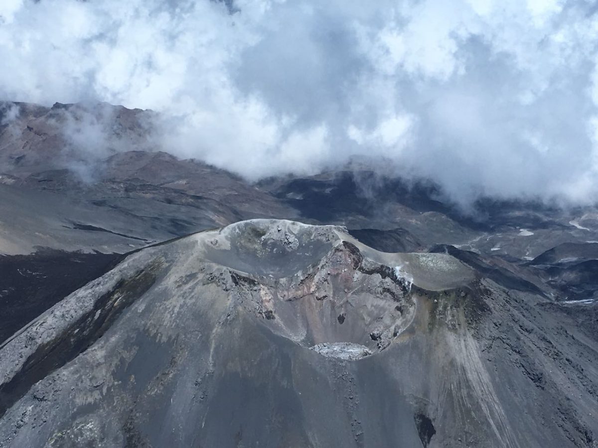
Kilauea , Hawai :
19°25’16 » N 155°17’13 » W,
Summit Elevation 4091 ft (1247 m)
Current Volcano Alert Level: WATCH
Current Aviation Color Code: ORANGE
Activity Summary:
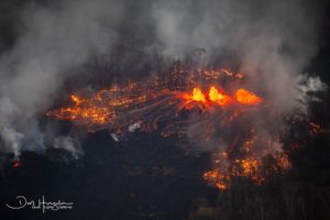
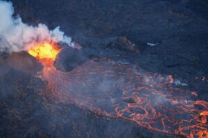
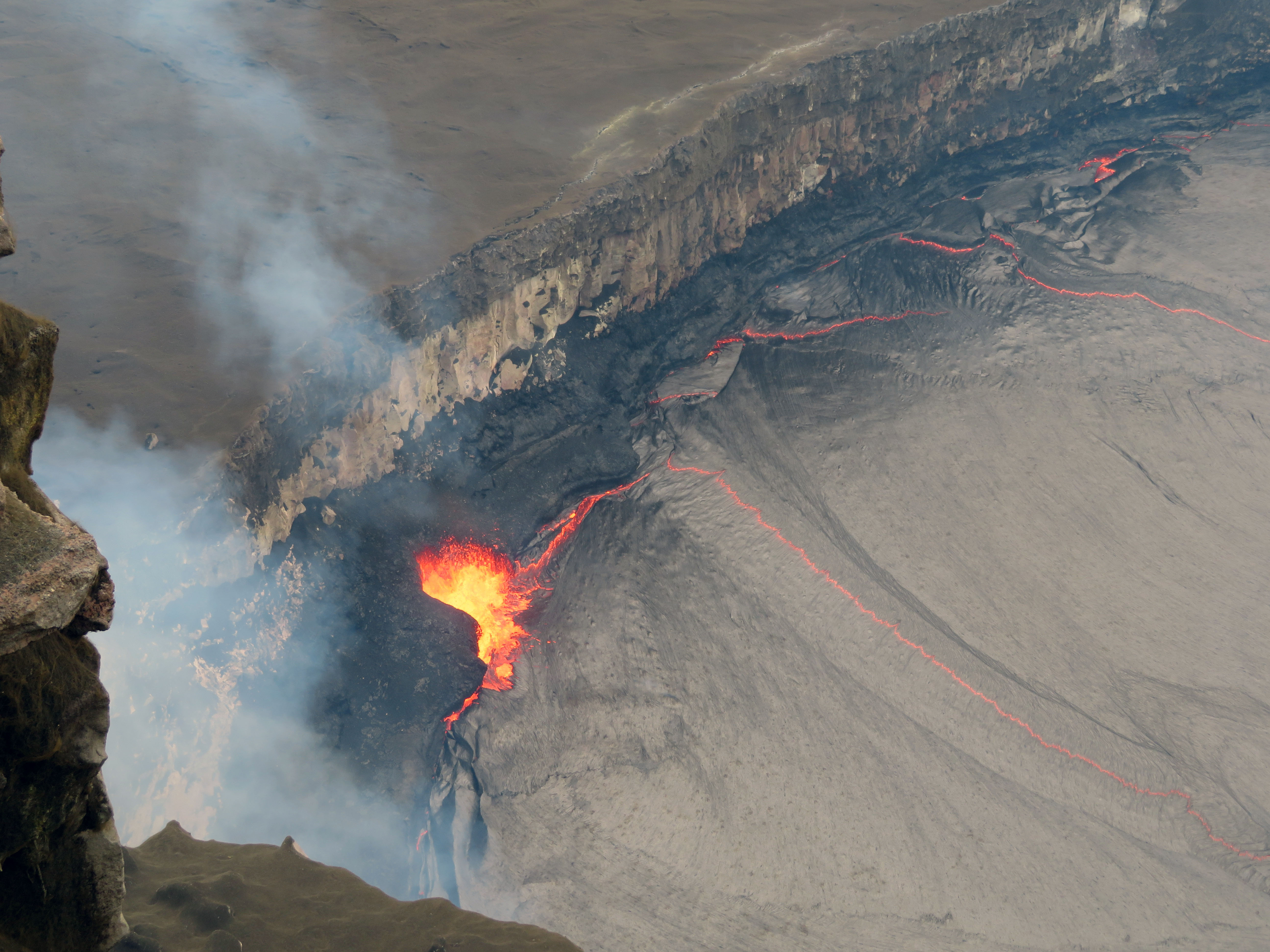
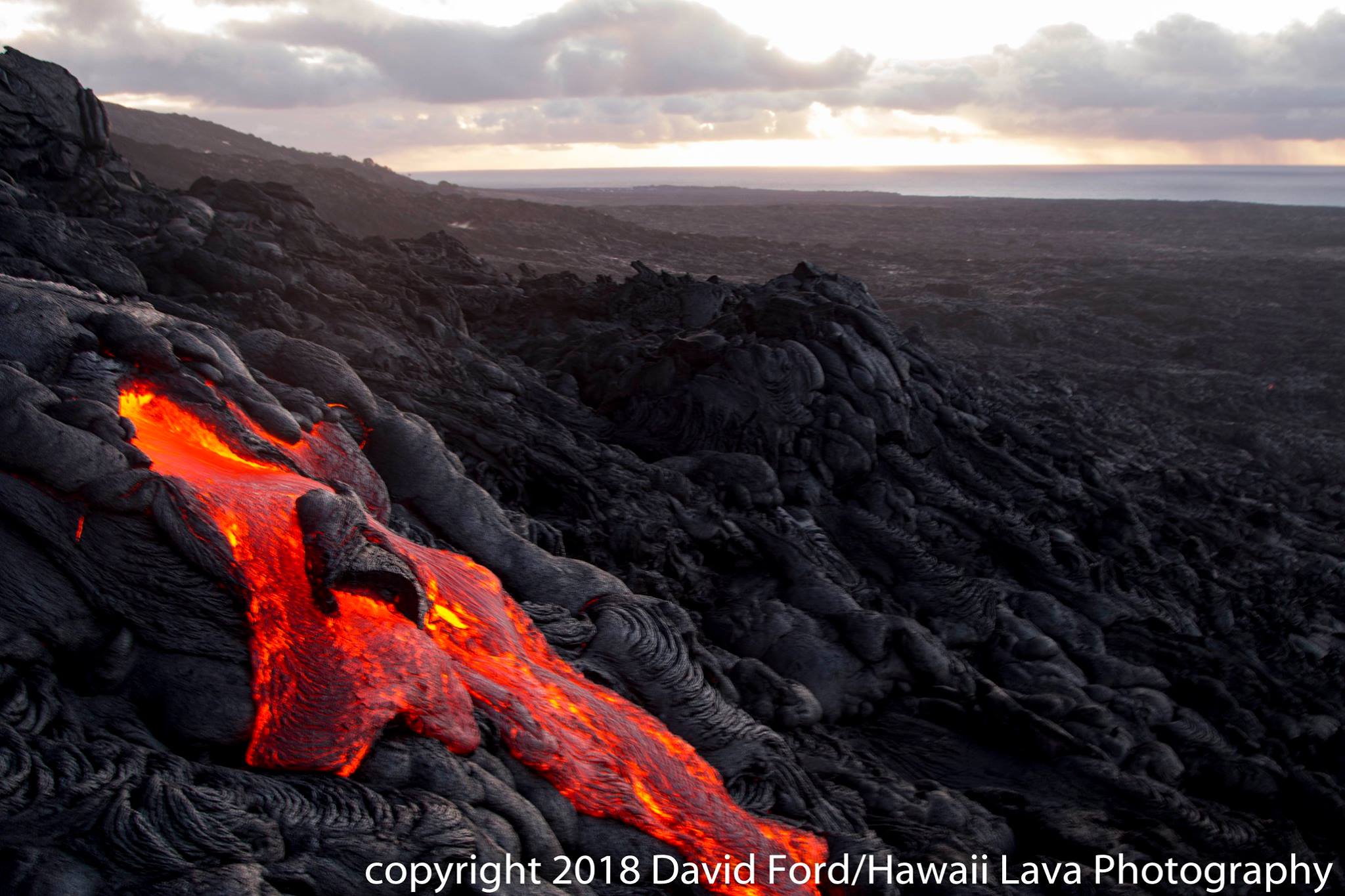
Eruptions at Kīlauea Volcano’s summit and East Rift Zone continue with no significant changes. The Episode 61g lava flow continues to produce surface flows on the upper portion of the flow field and on Pulama pali. Lava is not entering the ocean at this time. These lava flows pose no threat to nearby communities. The summit lava lake was 39 m (128 pi) below the floor of Halemaʻumaʻu this morning. Low rates of ground deformation and seismicity continue across the volcano.
Summit Observations:
Summit tiltmeters recorded deflationary tilt, consistent with the deflation phase of a summit DI event (see definitions below). The height of the summit lava lake fell to 39 m (128 pi) below the rim of the Overlook crater when measured this morning. An ongoing long-period earthquake swarm at 5-10 km depth beneath the caldera began last night. Otherwise, seismicity is within normal, background rates, with tremor fluctuations associated with lava lake spattering. Summit sulfur dioxide emission rates remain high.
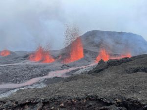
Puʻu ʻŌʻō Observations:
Available webcam images over the past 24 hours show persistent glow at long-term sources within the crater and from a small lava pond on the west side of the crater. A small amount of inflationary tilt was recorded over the past day. The sulfur dioxide emission rate from the East Rift Zone vents has been steady over the past several months and remains significantly lower than the summit emission rate.
Lava Flow Observations:
The episode 61g flow is still active, but no lava is flowing into the ocean. Webcams show continuing surface flow activity on the upper portion of the flow field and on Pulama pali. None of these flows poses any threat to nearby communities at this time.
DI event: « DI » is short for « deflation-inflation. » A DI event is an abrupt deflation of Kīlauea’s summit that lasts from several hours to 2-3 days, followed by an abrupt transition to inflation that effectively cancels the preceding deflation over the ensuing hours to days. DI events are best recorded by tiltmeters at Kīlauea’s summit, which typically measure a few microradians (see definition below) of change for individual events. DI events indicate a decrease and subsequent increase in pressure within a magma reservoir located about 1.5 km (1 mi) beneath the east margin of Halema‘uma‘u Crater. The level of the summit lava lake generally tracks tilt during DI events, with the lava level dropping during the deflation phase and rising during the inflation phase. Many DI events at Kīlauea’s summit are also recorded, after a delay of minutes to hours, by a tiltmeter on the north flank of Pu‘u ‘Ō‘ō on Kīlauea’s East Rift Zone, which is a sign that the pressure changes at the summit are being transmitted through the magma conduit to the East Rift Zone eruption site. DI events sometimes correlate with pauses and pulses in lava output from East Rift Zone eruptive vents.
7 MARCH 2018. An ongoing long-period earthquake swarm at 5-10 km depth began last night beneath the Kīlauea Volcano caldera, scientists report, noting that “otherwise, seismicity is within normal, background rates, with tremor fluctuations associated with lava lake spattering.”
On Tuesday, the USGS Hawaiian Volcano Observatory measured the level of the lava lake at 74 ft. below the floor, which meant excited visitors could catch a glimpse of lava spatter from the Jaggar Overlook inside Hawai‘i Volcanoes National Park. The next day, the height of the summit lava lake fell to 102 ft. below the rim of the Overlook crater.
The USGS Volcano Monitoring Data at Kīlauea shows a series of colored circles around the summit, tracking the quakes that ocurred in the last two days (orange) or the last two hours (red). The map illustrates the “long-period earthquake” that scientists say began Tuesday night.
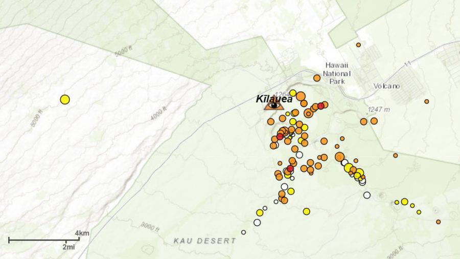
According to a USGS Volcano Hazards Program webpage: Long-period (LP) or low-frequency (LF) earthquakes are caused by cracks resonating as magma and gases move toward the surface. They are often seen prior to volcanic eruptions, but their occurrence is also part of the normal background seismicity at some volcanoes and their occurrence does not necessarily indicate that an eruption is imminent. LF events can also be produced by non-magmatic processes.
9/03 / 2018.The long-lasting type of earthquake swarm that started on Tuesday night under the Kīlauea volcano caldera seems to have ended.
The USGS Hawaiian Volcano Observatory found that the seismicity of the summit area had returned to normal background levels, with tremor fluctuations associated with splashing of the lava lake. The deflationary slope continues to be recorded.
Source : HVO , Big Island videonews.
Photos : HVO , David Ford.
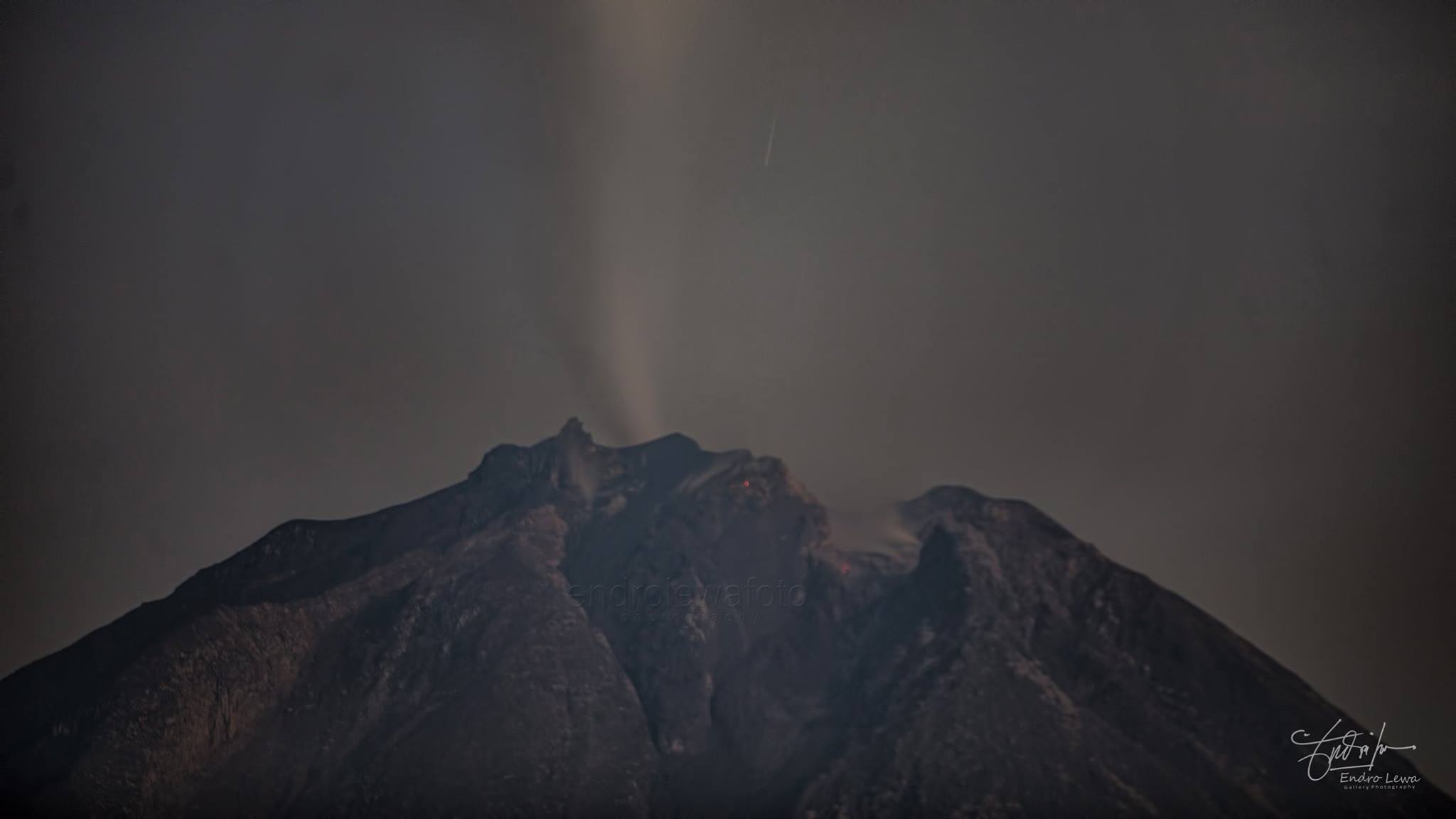
Shinmoedake , Japan :
Explosive eruptions are continuing on Mount Shinmoe in southwestern Japan.
The volcano is in the Kirishima range, straddling Kagoshima and Miyazaki prefectures.
The Meteorological Agency said the volcano first blew up on Tuesday afternoon. It was the first major eruption in 7 years, and 10 similar explosions have been recorded so far. One at midnight spewed large volcanic rocks as far as 900 meters away.
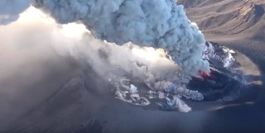
Agency officials said the smoke rose the highest ever at 3,000 meters above the crater just past 6 AM on Wednesday.
They said they are keeping the alert level at 3 on a scale of 1 to 5, advising people not to go near the mountain.
They are warning of flying rocks within 3 kilometers of the crater, and pyroclastic flows of hot ash and rocks within 2 kilometers.
Minor eruptions had been occurring at the volcano since Thursday last week.
Source : 3NHK
Photo : via Sherine France.
Nevados de Chillan , Chile:
During this period, 3537 seismic events, of which seventy (60) were classified as volcano-tectonics (type VT), associated with fracturing processes of rigid materials, of local magnitude (ML) less than or equal to m 1, 9 have been registered. The most energetic event was located 5.1 km southeast (SE) of the active crater at a depth of 1.4 km.
⦁ Similarly, 3477 earthquakes associated with fluid dynamics within the volcano, of which 2358 were classified as Long Period Type (LP) events, with a reduced maximum displacement value (DRC) of 205 cm2. have been registered. In addition, 1119 tremor (TR) events were recorded, the largest of which lasted approximately 3 minutes with a maximum reduced displacement value of 171 cm2.
⦁ From February 16 to 28 there was a total of 679 explosions associated mainly with magmatic gases and / or the recording of acoustic signals picked up by the network of microphones installed on the slopes of the volcano, which measured a maximum pressure reduced by 0.3 Pa at 1 km on the highest recorded seismic energy explosion.
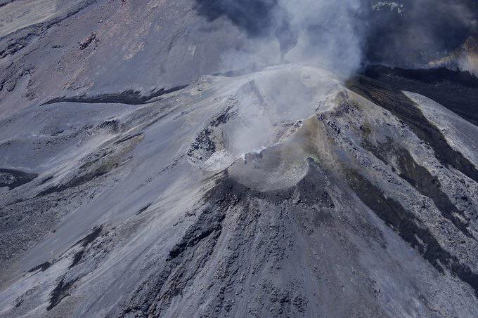
⦁ On 22 February, an overflight was carried out where no significant morphological changes were observed, but an increase in the volume of the dome was observed compared to previous observations, reaching about 92,500 m3 at that date and an equal growth rate at 0.02m3 / sec. .
⦁ From the geodetic data, there are very small changes, due to very subtle volume changes within the volcanic building produced in recent months, which is consistent with the activity recorded from 2016 to date.
⦁ Sulfur dioxide (SO2) emissions recorded by the Differential Absorption Spectrometry Equipment (DOAS) at the Chillán station, located 2.6 km southeast of the active crater, had an average monthly value of 463 ± 687 t / day and a daily maximum value of 3045 t / day, measured on February 22nd. S02 emissions are at low levels for this volcano, consistent with the presence of the lava dome.
⦁ The IP cameras installed near the volcano recorded a constant degassing of the active crater, characterized by sporadic emissions of ash and water vapor, mostly from a maximum height of 1080 m. For a few days, during the night, the incandescence was visualized when the weather conditions made it possible to observe the volcano.
No sulfur dioxide (SO 2) emissions have been reported in the area near the volcanic complex, according to data published by the Ozone Monitoring Instrument (OMI) Sulfur Dioxide Group (http: // so2.gsfc.nasa.gov/) and the National Environmental Satellite Information and Data Service (NESDIS) (http://satepsanoine.nesdis.noaa.gov).
No thermal alerts were reported from the data processed by the Medium Infrared Observation of Volcanic Activity (MIROVA) (http://www.mirovaweb.it/) and the near-real-time thermal monitoring. global hot spots (MODVOLC) (http://modis.higp.hawaii.edu/).
The explosive activity continues, associated with the growth of the Gil-Cruz lava dome, located in the Nicanor crater, with a quasi-uniform growth rate, which is reflected in the energy stability of the recorded seismic phase. The body of the dome continues to be stable, with no significant collapse of its structure, with the majority of explosions occurring across the south-east / northwest trending fracture. The destruction of this dome could be associated with a vulcanian-type explosion of greater magnitude than currently recorded, associated with pyroclastic flows and material falls in the volcano area.
For all this, the level of activity is maintained at the level: LEVEL YELLOW: Changes in the behavior of the volcanic activity – Probable time for an eruption: WEEKS / MONTH.
Observation: It is recommended to apply precautionary access restrictions in an area close to the crater with a radius of 4 kilometers around the active crater
Source : Sernageomin
Sinabung , Indonesia :
Level IV Activity Level (AWAS). The Sinabung (2460 m altitude) has been erupting constantly since 2013.
Since yesterday until this morning the volcano has been observed until it is covered with fog. The smoke coming out of the crater could be observed of white / gray color, of low pressure, with a height of 50 to 300 m above the summit. Surface activity was not accompanied by eruption. The wind is blowing low to moderate in the west.
According to the seismographs of March 08, 2018, it was recorded:
3 earthquakes of emission.
1 distant tectonic earthquakes.
1 low frequency earthquake
2 phase / hybrid earthquakes
8 shallow volcanic earthquakes (VB)
30 deep volcanic earthquakes (VA)
1 local tectonic earthquake.
Recommendations:
Communities / visitors should not do activities within 3 km of the summit, and by sector, 7 km to the South-South-East, 6 km East-South-East and 4 km to the South-East. km northeast.
The deposits formed a dam upstream on the Laborus River. People living in downstream river basins and around the Laborus River need to be vigilant because these dams can collapse at any time and no longer retain water volume, resulting in downstream lahars / floods .
Vona: The last Vona code issued was a color code ORANGE, published on February 26, 2018 at 18:44, associated with the eruption at 13:39 where the height of the ash column was observed up to 3160 m above the sea level, about 700 m above the summit, the wind blowing south-southeast.
Source : Magma , VSI.