November 9 , 2025.
Kamchatka , Krasheninnikov :
VOLCANO OBSERVATORY NOTICE FOR AVIATION (VONA)
Issued: November 9 , 2025
Volcano: Krasheninnikov (CAVW #300190)
Current aviation colour code: ORANGE
Previous aviation colour code: orange
Source: KVERT
Notice Number: 2025-132
Volcano Location: N 54 deg 35 min E 160 deg 16 min
Area: Kamchatka, Russia
Summit Elevation: 1856 m (6087.68 ft)
Volcanic Activity Summary:
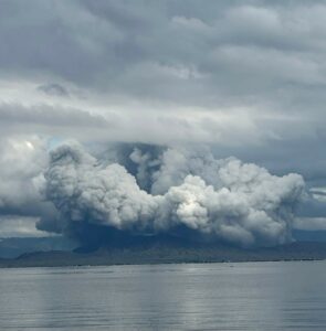
Satellite data by KVERT shows a strong wind lifts ash from the eastern slopes of Krasheninnikov volcano, and a plume of resuspended ash is extending for about 160 km to the east-south-east of the volcano.
There is NO eruption, but an resuspended ash. Ongoing activity could affect low-flying aircraft.
Volcanic cloud height:
2000-2500 m (6560-8200 ft) AMSL Time and method of ash plume/cloud height determination: 20251109/0300Z – Himawari-9 14m15
Other volcanic cloud information:
Distance of ash plume/cloud of the volcano: 160 km (99 mi)
Direction of drift of ash plume/cloud of the volcano: ESE / azimuth 122 deg
Time and method of ash plume/cloud determination: 20251109/0300Z – Himawari-9 14m15
Remarks:
The first historical eruption of the volcano began on 02 August, 2025. The explosive-effusive eruption of the volcano continues. The previous effusive eruption of the volcano occurred 400-600 years ago.
Source : Kvert.
Photo : Yuri Doubik (Institute of Volcanology, Petropavlovsk), via GVP.
Hawaii , Kilauea :
HAWAIIAN VOLCANO OBSERVATORY DAILY UPDATE , U.S. Geological Survey
Saturday, November 8, 2025, 9:03 AM HST (Saturday, November 8, 2025, 19:03 UTC)
19°25’16 » N 155°17’13 » W,
Summit Elevation 4091 ft (1247 m)
Current Volcano Alert Level: WATCH
Current Aviation Color Code: ORANGE
During the lapse in appropriations, the USGS Hawaiian Volcano Observatory (HVO) continues to maintain monitoring networks and issue updates and notifications of volcanic activity via the Hazard Notification Service. Volcano monitoring data will continue to be available on the HVO website. Static website content will not be updated until further notice and information may become outdated over time.
Activity Summary:
Overflows of degassed lava continued from the north vent throughout the past 24 hours. Inflation of Kīlauea’s summit continued at a slow rate yesterday.. However, periods of strong glow overnight from the north and south vents and the occurrence of overflows from the north vent indicate the start of episode 36 may be close. Inflation-based models suggest a likely forecast window of November 8–11 for episode 36.
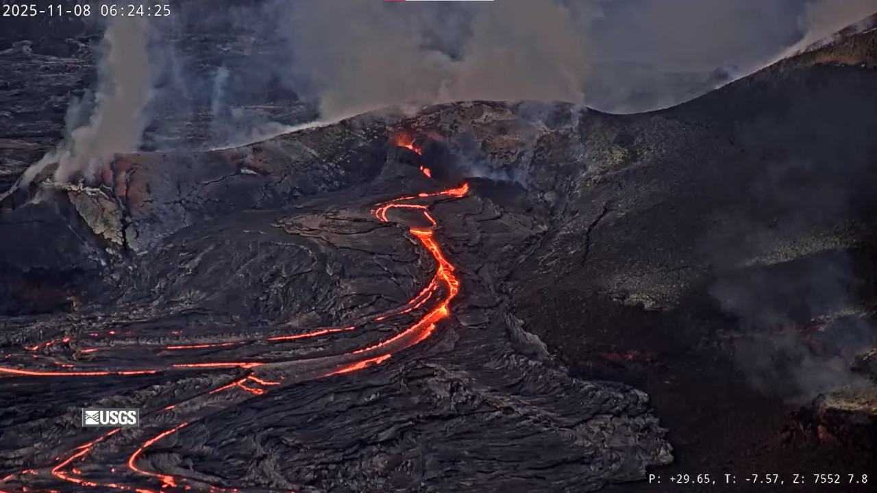
Summit Observations:
Intermittent overflows, lasting from a few minutes to 2 hours, from the north vent continued throughout yesterday and this morning. These overflows display limited spattering until drainback, indicating that mostly degassed magma is being erupted at this time. A cone has built around the vent on the back wall of the north vent, which at times erupts vigorously and main remain pouring lava back into the main vent during drainback events. A total of 135 precursory overflow events have occurred since early morning on November 3.
Summit inflation continued yesterday, but the rate has since reduced overnight. Overall, the Uēkahuna tiltmeter (UWD) has recorded approximately 0.6 microradian of inflationary tilt over the past 24 hours yielding 26.7 microradians of inflationary tilt since the end of episode 35. After overflow activity resumed at the north vent on November 6, periods of low tremor correlating with pond filling and/or overflows is followed by 1-2 minute long tremor spikes related to drainback.
Plumes of gas continue from both vents this morning and sulfur dioxide (SO2) gas emissions remain at background levels, typically between 1,200 and 1,500 tonnes per day. Current wind conditions at the summit are light and variable and could pose a problem for communities adjacent to Hawai’i Volcanoes National Park if high fountains began under these conditions.
Source et photo : HVO.
Chile , Planchón-Peteroa volcanic complex :
Special Volcanic Activity Report (REAV), Maule Region, Planchón-Peteroa Volcanic Complex
November 8, 2025, 5:00 PM local time (Mainland Chile)
The Chilean National Geological and Mining Service (Sernageomin) is publishing the following PRELIMINARY information, obtained through monitoring equipment of the National Volcanic Monitoring Network (RNVV), processed and analyzed at the Southern Andes Volcanological Observatory (OVDAS):
Today, Saturday, November 8, monitoring stations located near the Planchón-Peteroa Volcanic Complex recorded a long-period (LP) earthquake associated with internal fluid dynamics.

The earthquake’s characteristics after analysis are as follows:
TIME OF ORIGIN: 3:46 PM local time (6:46 PM UTC)
DISPLACEMENT: 42.5 cm
OBSERVATIONS:
The prevailing weather conditions in the region at the time of the earthquake prevented observation of surface activity at the volcanic complex.
The Yellow Volcano Alert remains in effect.
Source et photo : Sernageomin
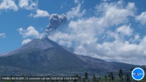
Ecuador , Sangay :
DAILY REPORT ON THE STATE OF SANGAY VOLCANO, Saturday, November 8, 2025.
Geophysical Information Institute – EPN.
Surface Activity Level: Moderate, Surface Trend: No Change
Internal Activity Level: Moderate, Internal Trend: No Change
Seismicity: From November 7, 2025, 11:00 AM to November 8, 2025, 11:00 AM:
Seismicity:
Below is the count of seismic events recorded at the reference station:
Explosion (EXP): 440
Rainfall/Lahars:
No rain has been recorded in the volcanic zone. **Heavy rainfall could remobilize accumulated material, generating mudflows and debris flows that would cascade down the volcano’s flanks and flow into adjacent rivers.**
Emission Column/Ash:
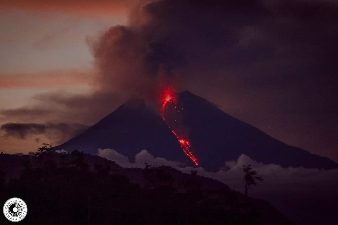
Several gas and ash emissions were observed by the monitoring camera system.
The plumes reached heights between 200 and 1,700 meters above the crater rim, all drifting southwest. The Washington VAAC agency issued four reports concerning gas and ash emissions, with plumes reaching 1,500 to 2,400 meters above the crater rim, drifting west-southwest and southwest.
Gas:
The MOUNTS satellite system detected 87.20 tons of SO₂ (sulfur dioxide), measured yesterday at 2:16 p.m. local time.
Other monitoring parameters:
Over the past 24 hours, the MIROVA MODIS and MIROVA VIIRS satellite systems recorded 3 and 6 thermal anomalies, respectively. The FIRMS satellite system detected 23.
Note:
From yesterday afternoon until the submission of this report, the volcano remained mostly cloud-covered. However, during the night and early this morning, incandescence was observed at the crater by the monitoring camera network, along with the descent of material to within 800 meters of the crater rim.
Alert level: Yellow
Source : IGEPN
Photo : Camara Rota / FB.
Colombia , Galeras :
San Juan de Pasto, November 4, 2025, 4:40 PM
Regarding the monitoring of activity at the Galeras volcano, the Colombian Geological Survey (SGC), an agency under the Ministry of Mines and Energy, reports the following:
During the week of October 28 to November 3, 2025, the main variations in monitored parameters compared to the previous week were as follows:
● Seismic activity and energy released decreased slightly, remaining at low levels. Seismicity associated with rock fracturing remains predominant.
● Seismicity was primarily localized to two sources. The first source was located within a 1 km radius of the Galeras volcano crater (4,200 m altitude), with low energy and a shallow depth (less than 4 km). The second source is located northeast of the Galeras volcano, at a distance of 13 km. Earthquakes in this area of activity occurred at depths between 6 and 11 km. The largest earthquake of this period (magnitude 1.7) occurred at this source, located northwest of the volcano’s crater, at a depth of 11 km. The remaining seismic activity was concentrated within the volcano’s sphere of influence.

● Low-altitude plumes of white gas were observed. These originated primarily from the fumarole fields of El Paisita (to the north) and Las Chavas (to the west). The dispersion of these plumes varied depending on wind direction and strength.
● Other volcanic monitoring parameters remained stable.
Given these factors, the Colombian Geological Survey (SGC) recommends closely monitoring the situation by consulting the weekly bulletins and other information disseminated through its official channels, as well as the instructions of local and departmental authorities and the National Unit for Disaster Risk Management (UNGRD).
Volcanic activity remains at the yellow alert level: active volcano exhibiting changes in the baseline behavior of monitored parameters and other manifestations.
Source et photo : SGC.