October 21 , 2025.
Iceland , Katla / Mýrdalsjökull :
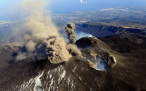
Today around 10:30 a strong seismic swarm began in Mýrdalsjökull glacier, four events over M3.0 and some aftershocks have followed. The largest event occurred at 10:51 of M4.4. Last time an earthquake of size over M3.0 in Mýrdalsjökull was detected on October 3rd 2025. In May and June 2023 a similar event occurred with few events larger than M3.0, where the largest events was M4,8. No signs of changes in water or conductivity levels in rivers draining the glacier.
The southern slopes of Mýrdalsjökull glacier.
Strong earthquake beneath Katla
On Monday, 20 October 2025, at 10:51:22 UTC, a magnitude 4.5 earthquake occurred beneath the Katla caldera. The hypocenter was located at a depth of 0.1 km, about 8.5 km east-northeast of Goðabunga.
This quake is the strongest event in an ongoing swarm that began at 10:27:49 UTC and has so far included 15 tremors. Two other clearly felt earthquakes reached magnitudes of 3.3 and 3.4.
A similarly strong earthquake last occurred on June 2023 when a tremors beneath Katla reached magnitude 4.8
Sources : IMO .
Photo : mbl.is/RAX
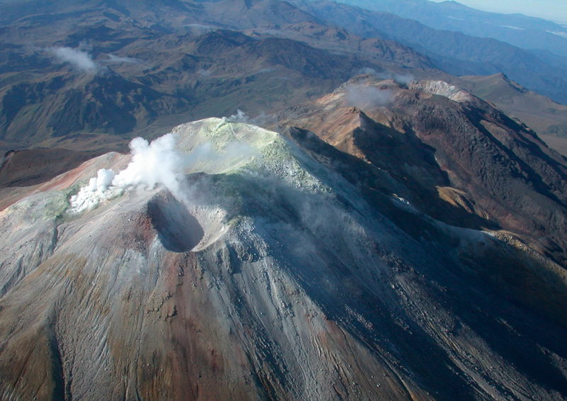
Colombia , Cumbal :
San Juan de Pasto, October 14, 2025, 2:40 p.m.
Regarding the monitoring of the activity of the Cumbal Volcanic Complex (CVC), the Colombian Geological Survey (SGC), an entity affiliated with the Ministry of Mines and Energy, reports that:
During the week of October 7 to 13, 2025, the main variations in the monitored parameters compared to the previous week were:
● An increase in seismic activity and energy release was recorded. The predominance of seismic activity associated with rock fracturing within the volcanic edifice continued.
● The earthquakes were located in different sectors of the summit of the volcanic complex, at distances less than 4.0 km and at depths less than 7.0 km from the summit (reference level around 4,700 m altitude) and with a maximum magnitude of 1.2.
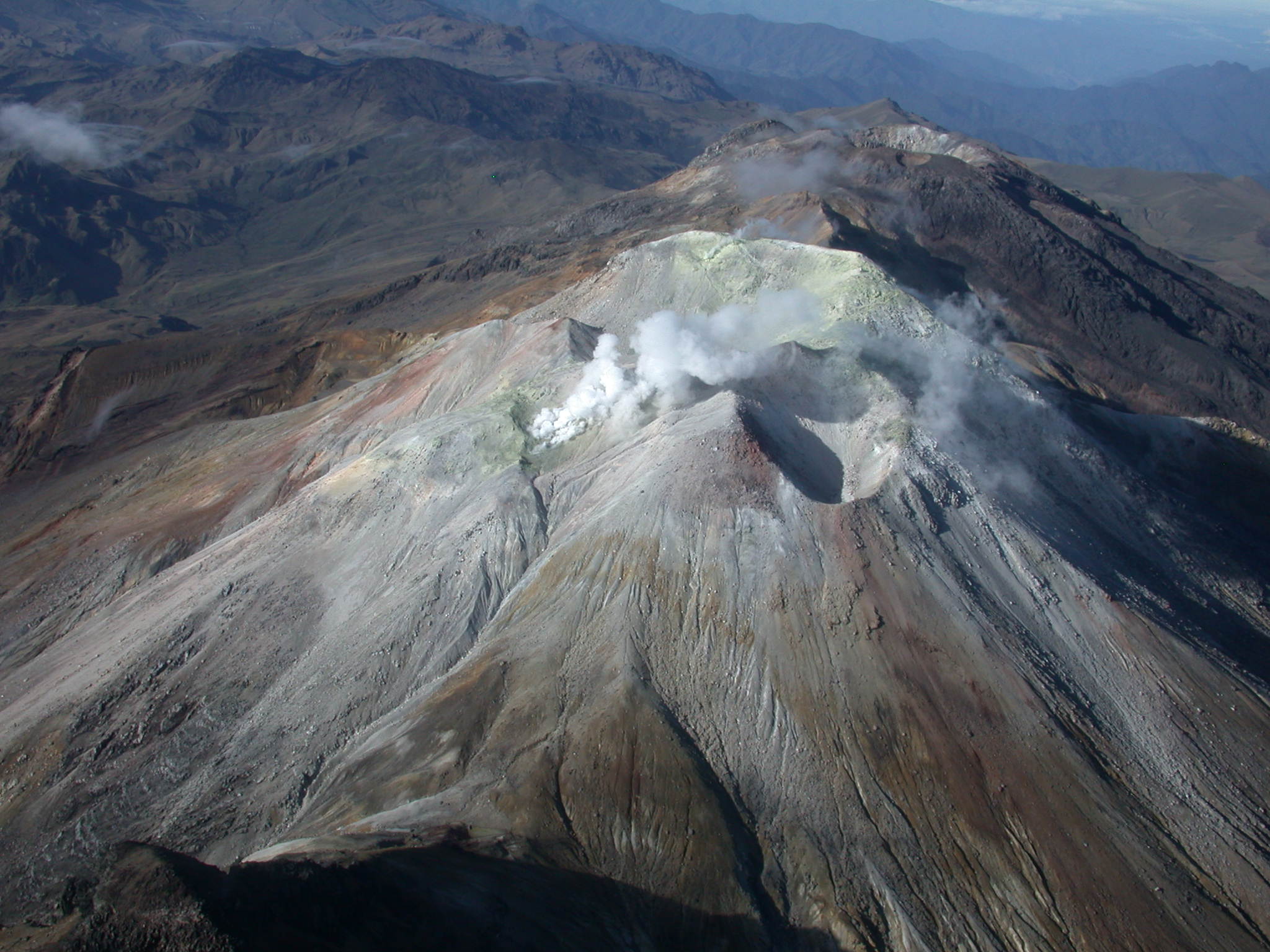
● White gas emissions were recorded, with variable dispersion depending on the wind, mainly coming from the El Verde fumarole field, located northeast of the CVC.
● Other volcanic monitoring parameters remained stable.
In view of the above, the SGC recommends closely monitoring their evolution through weekly bulletins and other information published through our official channels, as well as instructions from local and departmental authorities and the National Disaster Risk Management Unit (UNGRD).
Volcanic activity remains on alert. Yellow: Active volcano with changes in the baseline behavior of monitored parameters and other manifestations.
Source et photo : SGC.
Alaska , Shishaldin :
54°45’19 » N 163°58’16 » W,
Summit Elevation 9373 ft (2857 m)
Current Volcano Alert Level: ADVISORY
Current Aviation Color Code: YELLOW
Signs of volcanic unrest at Shishaldin continue this week. Sulfur dioxide gas emissions were detected in satellite data when viewing conditions were clear. Low-level seismicity is ongoing, and infrasound signals were detected on multiple days when the signals were not compromised by wind. The infrasound is probably associated with gas bubbles bursting deep within the crater. Steam emissions from the summit crater were observed in web camera images yesterday, but clouds have obscured the volcano for most of the week. Satellite data show no evidence of increased temperatures in the summit crater that would indicate lava at or near the surface.
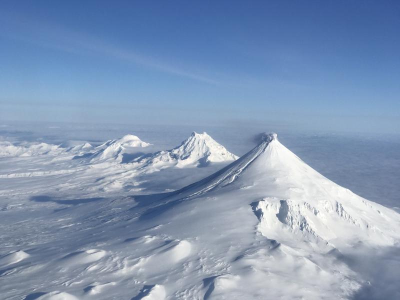
Shishaldin Volcano is monitored by local seismic and infrasound sensors, web cameras, and a telemetered geodetic network. In addition to the local monitoring network, AVO uses nearby geophysical networks, regional infrasound and lighting data, and satellite images to monitor the volcano.
Shishaldin Volcano, located near the center of Unimak Island in the eastern Aleutian Islands, is a conical stratovolcano with a base diameter of approximately 10 miles (16 km). It is one of the most active volcanoes in the Aleutian volcanic arc, with at least 54 episodes of unrest including over 28 confirmed eruptions since 1824. Most eruptions are relatively small, although activity during July – November 2023 generated ash columns that reached between 30,000 ft (9 km) and 42,000 ft (13 km) above sea level.
Source : AVO
Photo : Jacob, Ben David ( archive)
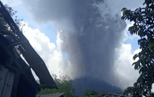
Guatemala , Santiaguito :
Atmospheric Conditions: Partly Cloudy
Wind: Northeast
Precipitation: 12.6 mm
Activity
Constant white and bluish outgassing is observed, reaching 200 meters above the Caliente Dome. Small explosions, occurring at a frequency of 2 to 5 per hour, lift columns of gas and ash up to 700 meters high, moving west and southwest with the wind. Incandescence is visible on the dome, as well as the detachment of incandescent rock blocks towards the west and southwest flanks.
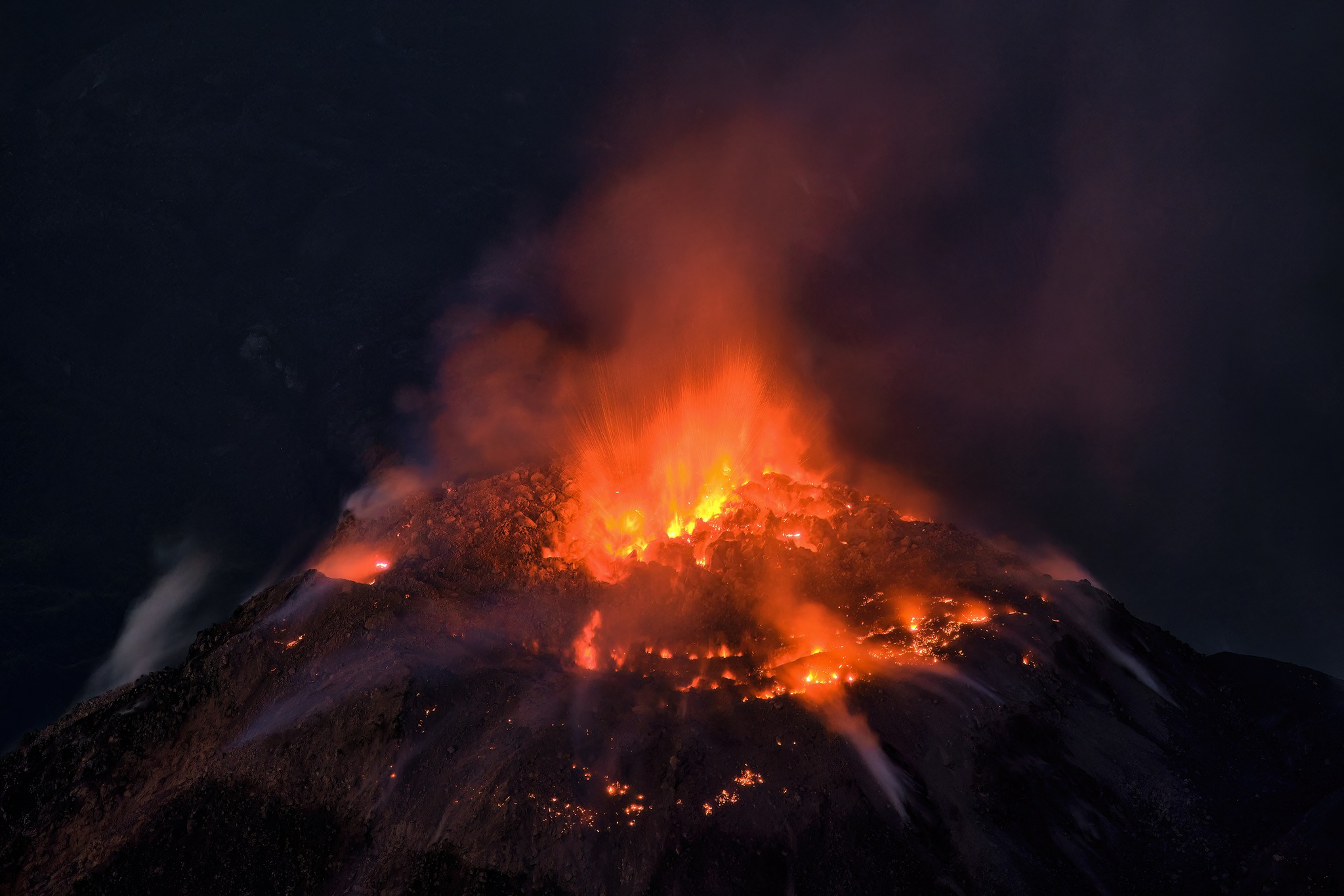
Due to the wind direction, fine ash particles are expected to fall on communities to the west and southwest. Due to the abundant accumulation of rocky material on the Caliente Dome and on the promontory above the lava flow on its southwest flank, long-distance pyroclastic density currents may be generated towards the southwest, south, southeast, and northeast. Precipitation around the volcanic edifice may generate currents and/or lahars in the various river channels. It is recommended to avoid staying in or near these ravines, especially in the afternoon and evening.
Source : Insivumeh
Photo : Thomas Spinner via FB . ( archive)
Hawaii , Kilauea :
HAWAIIAN VOLCANO OBSERVATORY DAILY UPDATE , U.S. Geological Survey
Monday, October 20, 2025, 9:44 AM HST (Monday, October 20, 2025, 19:44 UTC)
19°25’16 » N 155°17’13 » W,
Summit Elevation 4091 ft (1247 m)
Current Volcano Alert Level: WATCH
Current Aviation Color Code: ORANGE
During the lapse in appropriations, the USGS Hawaiian Volcano Observatory (HVO) continues to maintain monitoring networks and issue updates and notifications of volcanic activity via the Hazard Notification Service. Volcano monitoring data will continue to be available on the HVO website. Static website content will not be updated until further notice and information may become outdated over time.
Activity Summary:
Episode 35 of the ongoing Halemaʻumaʻu eruption ended on October 18 after 7.5 hours of continuous fountaining. Vent areas and lava flows continue to exhibit slow movement and/or incandescence as they cool and solidify. Kīlauea summit inflation immediately resumed following the end of episode 35 and continues along with tremor and vent glow. These observations indicate that another fountaining episode is probable, but likely at least two weeks away.
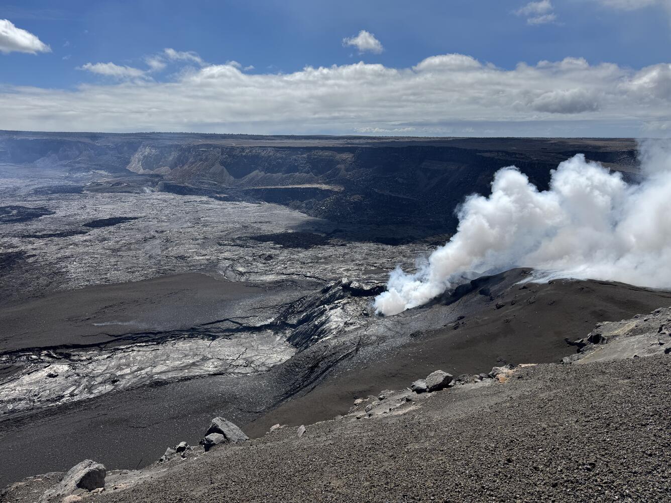
Summit Observations:
Intermittent glow, and possibly some flames, continued from both the north and south vents throughout the night, though the north vent was more persistent. Remobilized flows were sluggishly active through yesterday on the slopes around the cone. Additional secondary flows and creep of agglutinated tephra is possible in the coming days.
The summit continues to inflate. The Uēkahuna tiltmeter (UWD) recorded 2.5 microradians of inflationary tilt over the past 24 hours and 7.2 microradians of inflationary tilt since the end of episode 35. Tremor shows small spikes about every 5 minutes that are characteristic of gas pistoning of magma within the vents.
Plumes of gas are rising from both vents this morning and sulfur dioxide gas emissions remain at background levels, typically between 1,200 and 1,500 tonnes per day.
Episode 35 fountains began at approximately 8:05 p.m. HST on October 17 and ended at 3:32 a.m. on October 18. South vent fountains reached heights of nearly 1,500 feet (460 meters) and north vent fountains reached heights of about 1100 feet (330 meters). These were the highest single fountain and highest pair of fountains seen during this eruption so far. Episode 35 fountains produced an estimated 13 million cubic yards (10 million cubic meters) of lava. The combined average eruption rate was over 500 cubic yards per second (400 cubic meters per second) from the dual fountains. Lava flows from the fountains covered about two thirds of the floor of Halemaʻumaʻu crater.
Source : HVO
Photo : USGS / M. Patrick