October 13 , 2025.
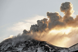
Kamchatka , Klyuchevskoy :
VOLCANO OBSERVATORY NOTICE FOR AVIATION (VONA)
Issued: October 13 , 2025
Volcano: Klyuchevskoy (CAVW #300260)
Current aviation colour code: ORANGE
Previous aviation colour code: orange
Source: KVERT
Notice Number: 2025-112
Volcano Location: N 56 deg 3 min E 160 deg 38 min
Area: Kamchatka, Russia
Summit Elevation: 4750 m (15580 ft)
Volcanic Activity Summary:
An ash plume is extending about 30 km to the east-south-east from the volcano during collapse inside the crater. KVERT continues to monitor Klyuchevskoy volcano.
A gas-steam activity with some amount of ash of the volcano continues. Ongoing activity could affect low-flying aircraft.
Volcanic cloud height:
6000-6500 m (19680-21320 ft) AMSL Time and method of ash plume/cloud height determination: 20251013/0230Z – Himawari-9 14m15
Other volcanic cloud information:
Distance of ash plume/cloud of the volcano: 30 km (19 mi)
Direction of drift of ash plume/cloud of the volcano: ESE / azimuth 117 deg
Time and method of ash plume/cloud determination: 20251013/0230Z – Himawari-9 14m15
Source : Kvert
Photo : Yu. Demyanchuk. IVyS Branche extrême-orientale de l’Académie des sciences de Russie, KVERT
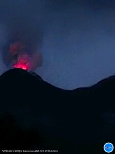
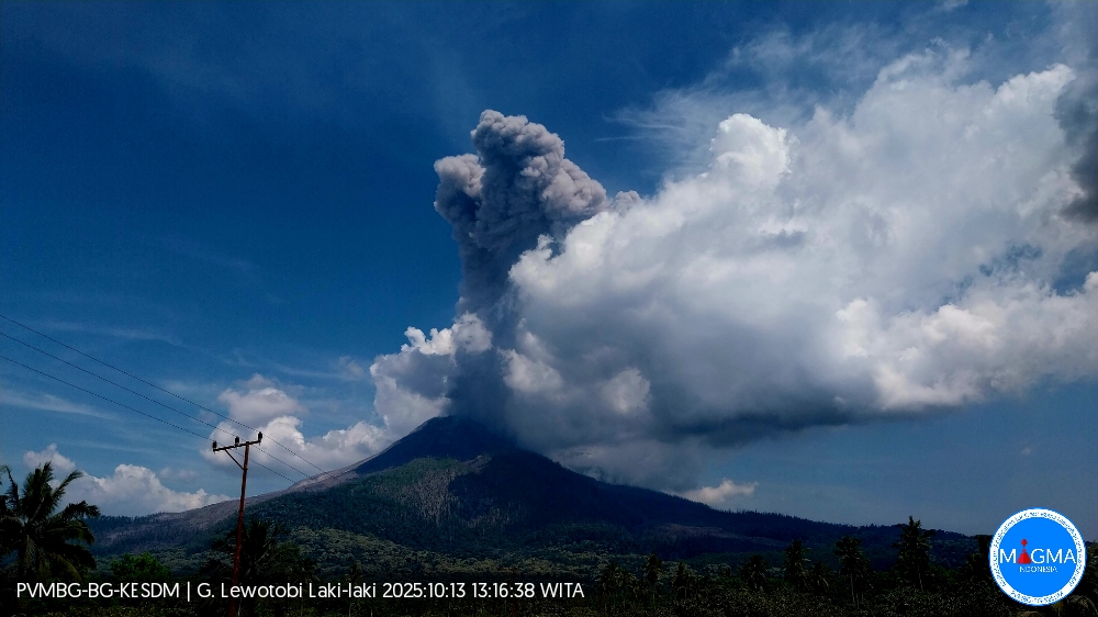
Indonesia , Lewotobi Laki-Laki :
An eruption of Mount Lewotobi Laki-laki occurred on Monday, October 13, 2025, at 1:13 PM WITA. An ash column was observed about 3,000 m above the summit (about 4,584 m above sea level). The ash column was gray and dense, oriented toward the west and northwest. This eruption was recorded by seismograph with a maximum amplitude of 18.5 mm and a duration of 91 seconds.
VOLCANO OBSERVATORY NOTICE FOR AVIATION – VONA
Issued : October 13 , 2025
Volcano : Lewotobi Laki-laki (264180)
Current Aviation Colour Code : ORANGE
Previous Aviation Colour Code : red
Source : Lewotobi Laki-laki Volcano Observatory
Notice Number : 2025LWK483
Volcano Location : S 08 deg 32 min 20 sec E 122 deg 46 min 06 sec
Area : East Nusa Tenggara, Indonesia
Summit Elevation : 5069 FT (1584 M)
Volcanic Activity Summary :
Eruption with volcanic ash cloud at 05h13 UTC (13h13 local).
Volcanic Cloud Height :
Best estimate of ash-cloud top is around 14669 FT (4584 M) above sea level or 9600 FT (3000 M) above summit. May be higher than what can be observed clearly. Source of height data: ground observer.
Other Volcanic Cloud Information :
Ash cloud moving from west to northwest. Volcanic ash is observed to be gray. The intensity of volcanic ash is observed to be thick.
Remarks :
Eruption recorded on seismogram with maximum amplitude 18.5 mm and maximum duration 91 second.
Source et photo : PVMBG.
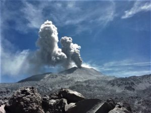
Guatemala , Fuego :
Atmospheric Conditions: Clear
Wind: Northeast
Precipitation: 21.7 mm
Activity
A white degassing fumarole is reported at an altitude of 4,100 meters. Between 7 and 12 weak and moderate explosions are generated per hour, projecting columns of gas and ash to altitudes of 4,300 to 4,800 meters (14,107 to 15,748 feet), which propagate southwestward for distances of up to 15 km. The explosions generate sounds, rumbles, and shock waves. At night, incandescent pulses are observed rising between 250 and 300 meters above the crater, covering the area with incandescent rock fragments.
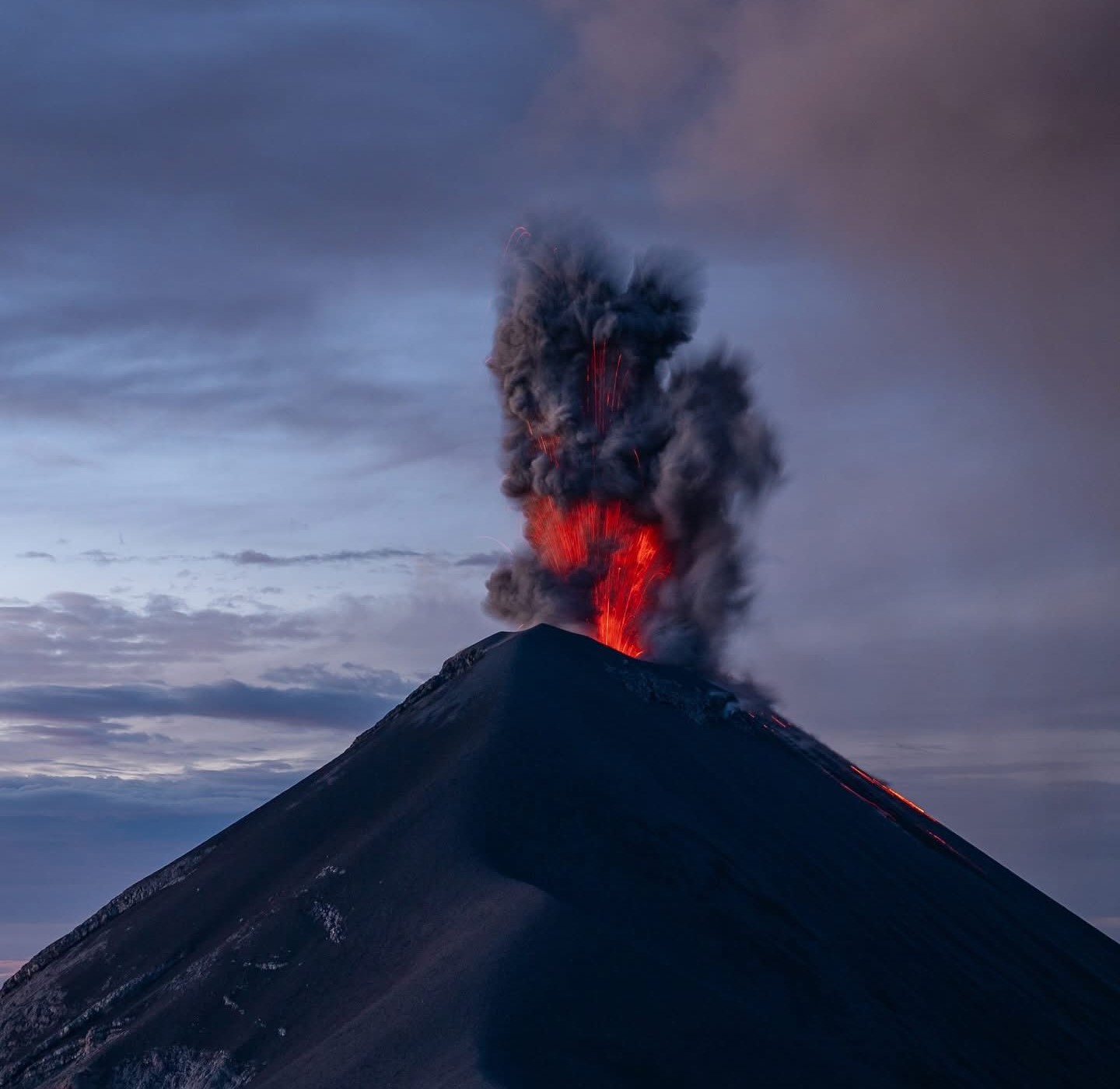
The Fuego Volcano Observatory (OVFGO) reports the collapse and fall of volcanic material from the vicinity of the crater. Ashfall is occurring in Panimaché I and II, Morelia, Sangre de Cristo, Finca Palo Verde, and other areas. In the afternoon and evening, rains could cause lahars in several ravines of the volcano. Therefore, it is recommended to follow the recommendations outlined in bulletin BEFGO-013-2025.
Source : Insivumeh
Photo : Diego Rizzo.
Hawaii , Kilauea :
HAWAIIAN VOLCANO OBSERVATORY DAILY UPDATE , U.S. Geological Survey
Sunday, October 12, 2025, 8:38 AM HST (Sunday, October 12, 2025, 18:38 UTC)
19°25’16 » N 155°17’13 » W,
Summit Elevation 4091 ft (1247 m)
Current Volcano Alert Level: WATCH
Current Aviation Color Code: ORANGE
During the lapse in appropriations, the USGS Hawaiian Volcano Observatory (HVO) continues to maintain monitoring networks and issue updates and notifications of volcanic activity via the Hazard Notification Service. Volcano monitoring data will continue to be available on the HVO website. Static website content will not be updated until further notice and information may become outdated over time.
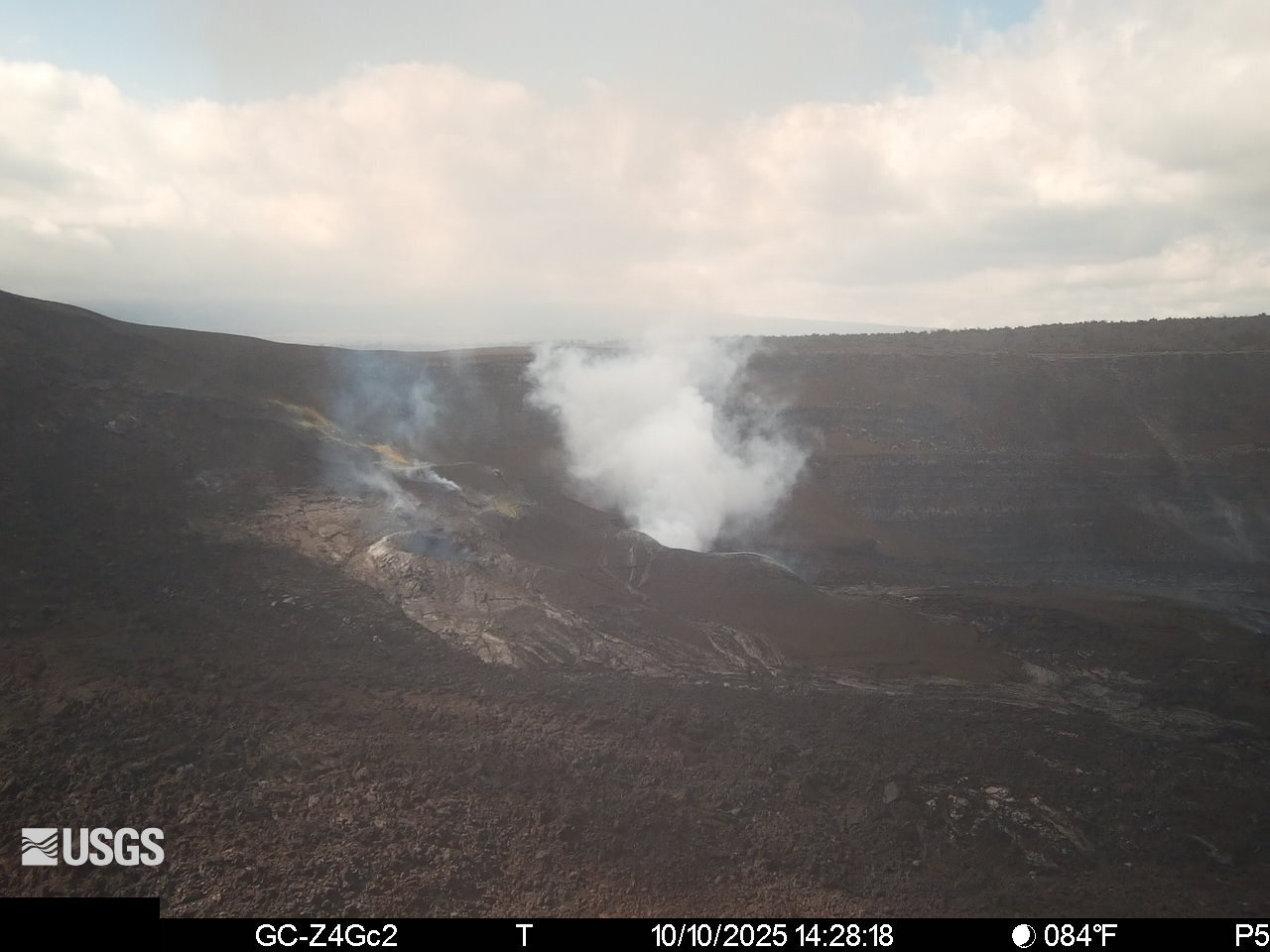
Activity Summary:
Episode 34 lava fountaining ended October 1 at 7:03 a.m. HST after approximately 6 hours of continuous activity. Variable incandescence was visible in both the north and south vents last night, indicating that magma remains within the conduits. Seismic tremor indicates that gas piston events continue within the vents, but are more irregular compared to the past several days. Kīlauea’s summit region continued to inflate over the past 24 hours, with rates indicating that the next fountaining episode is likely to start between October 17 and 21.
Summit Observations:
Halema’uma’u has been quiet again this morning with passive outgassing plumes rising from the north and south vents. Variable moderate to bright incandescence visible in the south vent last night was significantly more prominent than the less frequent weak to moderate incandescence visible in the north vent. The variable nature of the glow roughly correlates with irregular seismic tremor, but the patterns are less pronounced. This indicates that gas piston activity continues within both vents but at less regular intervals compared to the past several days. The UWD tiltmeter shows continued inflationary tilt after losing 0.5 microradians late last night. As of this morning, the tiltmeter has recovered a total of approximately 18 microradians since episode 34 ended.
Source and photo : HVO.
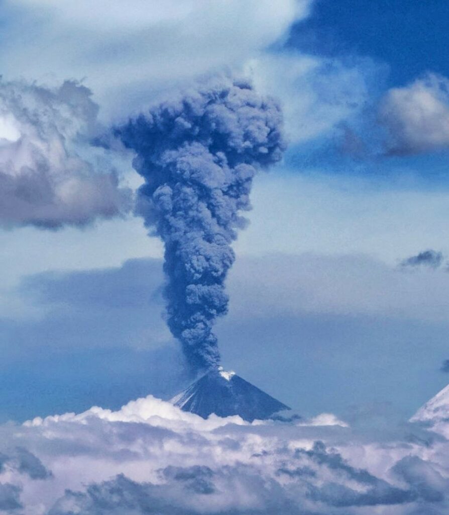
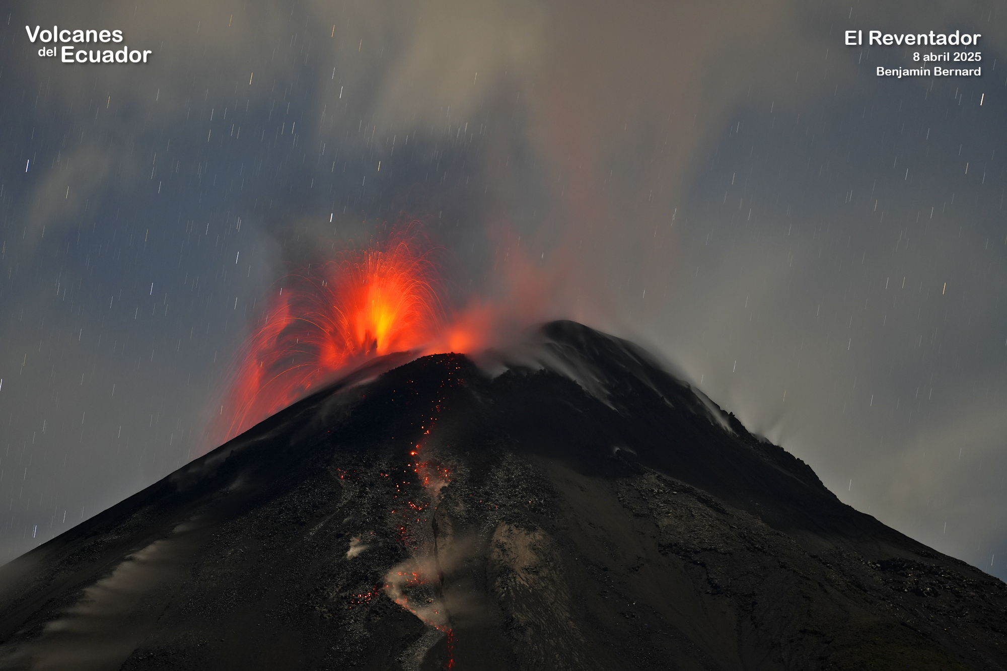
Ecuador , El Reventador :
DAILY STATUS REPORT OF REVENTADOR VOLCANO, Sunday, October 12, 2025.
Information Geophysical Institute – EPN.
Surface Activity Level: High, Surface Trend: Ascending
Internal Activity Level: Moderate, Internal Trend: Ascending
From October 11, 2025, 11:00 a.m. to October 12, 2025, 11:00 a.m.:
Seismicity:
Below is the count of seismic events recorded at the reference station.
Explosion (EXP) 22
Long Period (LP) 12
Emission Tremor (TREMI) 14
Harmonic Tremor (TRARM) 2
Rainfall / Lahars:
No rainfall has been recorded in the volcanic area. **Heavy rainfall could remobilize accumulated material, generating mud and debris flows that would cascade down the volcano’s flanks and flow into adjacent rivers.**
Emissions / Ash Plume:
Since yesterday afternoon, several gas and ash emissions have been observed by surveillance cameras, reaching heights of up to 1,500 meters above the crater, in a west and southwest direction. Regarding this activity, the Washington-based VAAC agency has published two emission reports, with heights of 1,000 and 1,600 meters above the crater, in a west direction, respectively.
Other monitoring parameters:
The FIRMS satellite system recorded 7 thermal anomalies, the MIROVA-VIIRS satellite system 4 thermal anomalies, and the MIROVA-MODIS satellite system 1 thermal anomaly over the past 24 hours.
Observation:
Last night and early this morning, surveillance cameras recorded several episodes of incandescent material falling on the volcano’s flanks, up to 1,100 meters below the crater level. At the time of writing, the volcano remains cloudy.
Alert Level – SGR: Orange
Source : IGEPN
Photo : Benjamin Bernard.