October 1 , 2025.
Italy / Sicily , Etna :
WEEKLY BULLETIN, September 22-28, 2025. (Publication date: September 30, 2025)
ACTIVITY STATUS SUMMARY
Monitoring data reveal the following:
1) VOLCANOLOGICAL OBSERVATIONS: Variable rate degassing in the summit craters. Low ash emissions in the Bocca Nuova crater.
2) SEISMOLOGICAL: Absence of seismic activity due to fracturing with Ml >=2.0; tremor amplitudes remained at average levels.
3) INFRASOUND: Moderate infrasound activity.
4) GROUND DEFORMATION: No significant variations were reported in the time series of ground deformation observation systems. 5) GEOCHEMISTRY: SO₂ fluxes at moderate levels.
CO₂ fluxes from the soil: low values.
Partial pressure of dissolved CO₂ in groundwater: no update available.
The helium isotope ratio is high at peripheral sites.
6) SATELLITE OBSERVATIONS: Thermal activity observed by satellite in the summit area was generally low.
VOLCANOLOGICAL OBSERVATIONS
Monitoring of Mount Etna’s volcanic activity was carried out through the analysis of images from the INGV Etneo Observatory (INGV-OE) surveillance camera network.
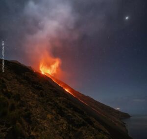
During the period studied, Etna’s activity was characterized by degassing of varying intensity and frequency at the summit craters and by low ash emissions from the Bocca Nuova crater. The presence of cloud cover or strong winds in the summit area for most of the week severely limited observations of volcanic activity.
Beginning at 5:00 UTC on September 23, a prolonged ash emission was observed from the Bocca Nuova crater, with dispersion limited to the summit area. Adverse weather conditions prevented monitoring of the phenomenon’s evolution in the hours that followed. With the restoration of good visibility on September 25, observations confirmed that ash emission had ceased; from dawn onward, activity was characterized by intense degassing, likely located near crater BN1.
Regarding the other summit craters, no significant changes were recorded compared to the previous week. The Northeast Crater (CNE) continued to show continuous degassing from a vent located on the crater floor. The Southeast Crater (CSE) and Voragine Crater (VOR) produced widespread degassing from several scattered fumaroles.
Source : INGV
Photo : Gio Giusa .
Italy , Stromboli :
WEEKLY BULLETIN, September 22-28, 2025. (Publication date: September 30, 2025)
ACTIVITY STATUS SUMMARY
Monitoring data reveal the following:
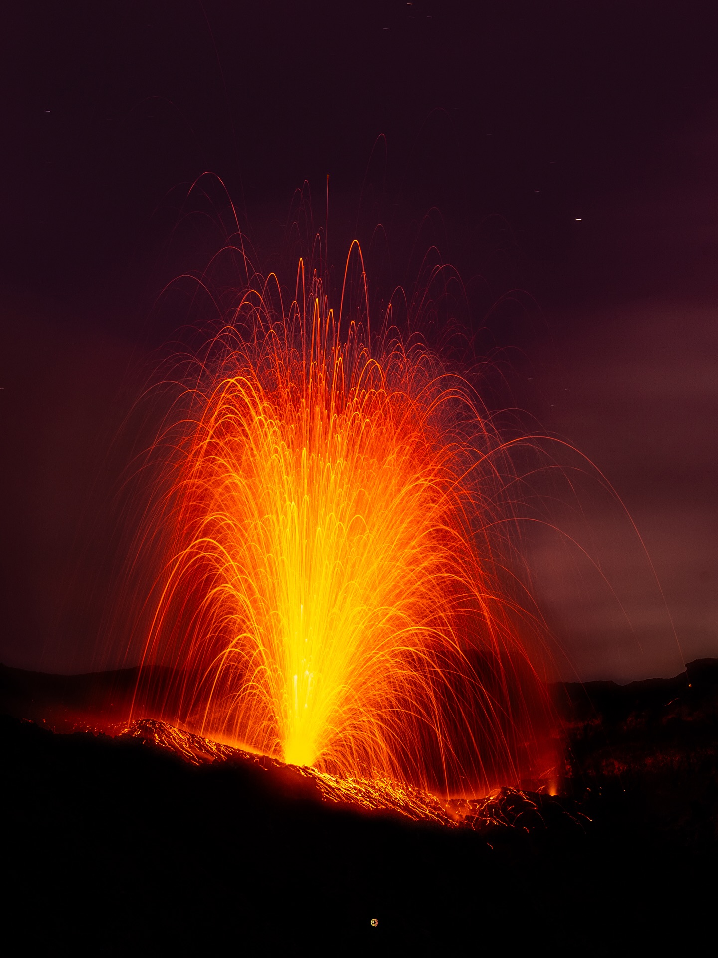
1) VOLCANOLOGICAL OBSERVATIONS: During this period, ordinary Strombolian eruptive activity was observed. The total hourly frequency fluctuated between high values (16 and 21 events/h).
Explosive intensity was low to medium in the North Crater area and low to high in the Center-South Crater area.
2) SEISMOLOGICAL: The monitored seismological parameters show no significant variation.
3) GROUND DEFORMATION: No significant variation is reported in the time series of ground deformation observation systems. 4) GEOCHEMISTRY: SO₂ flux at an average level
CO₂ flux from the soil in the Pizzo area (STR02): no update.
C/S ratio in the plume: no update. The most recent data are average values (September 9).
Helium isotope ratio (R/Ra): no update.
CO₂ flux in the soil in the San Bartolo area: low.
CO2 flux in the soil in the Scari area: high.
5) SATELLITE OBSERVATIONS: Thermal activity observed by satellite in the summit area was generally low, with some moderate thermal anomalies.
VOLCANOLOGICAL OBSERVATIONS
During the observation period, Stromboli’s eruptive activity was characterized by analyzing images recorded by the INGV-OE surveillance cameras located at an altitude of 190 m (SCT-SCV) and at Punta dei Corvi (SPCT). The cameras located at an altitude of 190 m (SCT-SCV) were active from 9:15 UTC on September 25 to 4:42 UTC on September 28. The explosive activity was mainly produced by four eruptive vents located in the North Crater area and at least two vents located in the Central-South area.
Observations of explosive activity captured by surveillance cameras
Four active vents were observed in the North (N) crater area, producing low-intensity explosive activity (less than 80 m in height) and occasionally medium-intensity explosive activity (less than 150 m in height). The eruptive products consisted mainly of coarse materials (bombs and lapilli). The average explosion frequency ranged between 9 and 12 events per hour.
In the South-Central (SC) crater area, two main vents were observed, exhibiting low- to high-intensity fine-material explosions and coarse-material explosions, respectively. The latter vent exhibited, during some explosions, a wide distribution of products reaching the edges of the crater terrace. The average explosion frequency ranged between 7 and 9 events per hour.
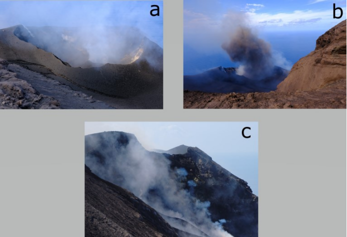
a) Central-South crater area CS, b) ash explosion in the CS area, c) North crater area N.
Observations following the inspection of September 25, 2025
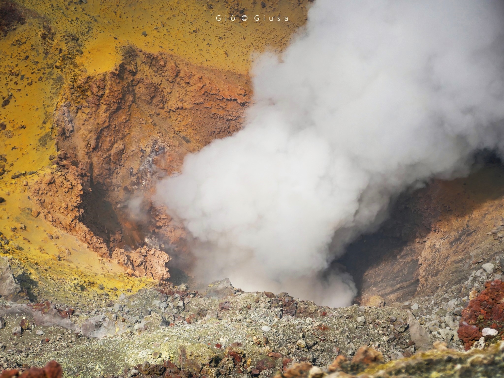
As part of the UNO Departmental Project and Annex A activities, on Thursday, September 25, INGV staff from the Etna Observatory inspected the summit area, where they observed the morphology of the crater terrace and eruptive activity, as well as the maintenance of the scientific instrumentation.
The crater terrace still exhibits craters in the northern area of the crater, located lower than the Central-South area. There is a large cone, the floor of which is clearly visible, having visibly enlarged since the last observations. At least three vents are recognizable, one of which formed a small cone exhibiting explosive activity interspersed with jets of mainly coarse but low-intensity material. During observations, the other two vents generated mainly ash emissions mixed with a small amount of coarse material. Between the cone and the southern rim of the crater terrace, numerous meter-sized bombs were clearly visible, in correlation with the strong episodic explosions that occurred last week. At least three vents with intense explosive activity are also visible in the northern area of the crater. In particular, a vent located near sector N1 produced vertical jets of incandescent material, while a vent in sector N2 produced a quasi-continuous emission of gas rings.
Source : INGV
Photos : Stromboli stati d’animo / Sebastiano Cannavo , INGV ( capture d’écran)
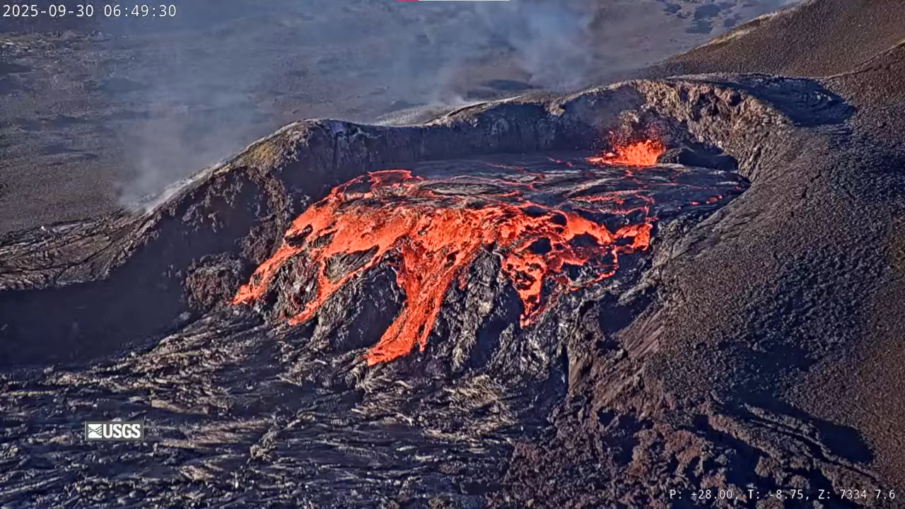
Hawaii , Kilauea :
HAWAIIAN VOLCANO OBSERVATORY DAILY UPDATE , U.S. Geological Survey
Tuesday, September 30, 2025, 8:50 AM HST (Tuesday, September 30, 2025, 18:50 UTC)
19°25’16 » N 155°17’13 » W,
Summit Elevation 4091 ft (1247 m)
Current Volcano Alert Level: WATCH
Current Aviation Color Code: ORANGE
Activity Summary:
Episode 33 lava fountaining ended on September 19. Glow from both north and south vents was observed overnight, with over 100 overflows from the north vent since September 28. The summit continues to inflate, and models indicate that episode 34 is most likely to start today, September 30, with small chance of starting tomorrow on October 1. No significant activity has been noted along Kīlauea’s East Rift Zone or Southwest Rift Zone.
Summit Observations:
Episode 33 lava fountaining ended at 12:08 p.m. HST on Friday, September 19. The UWD tiltmeter shows that the summit has been reinflating since the end of the fountaining episode, with 17 microradians of inflationary tilt. Overnight, HVO webcams showed persistent glow from north vent punctuated by over 200 gas piston cycles of lava filling and drainback, each lasting 2-10 minutes. Over 100 overflows were produced, mostly from 1:30 p.m. HST to just before midnight on September 29. There have only been 10 overflows since midnight with the last one occurring just before 6 a.m. HST. There was intermittent strong glow from south vent through the night and early morning. This morning, the caldera is quiet with a passive outgassing plume rising from the vents.
Elevated degassing continues from the vent. Average sulfur dioxide (SO2) emission rates during pauses are typically 1,200 to 1,500 t/d, though emission rates can vary on short time scales. Wind at Sand Hill, just south of Halemaʻumaʻu are blowing from the north to northeast direction, which suggests that volcanic gas emissions and volcanic material may be distributed south to southwest across the Ka’u desert within Hawaiʻi Volcanoes National Park.
Source : HVO
Photo : USGS
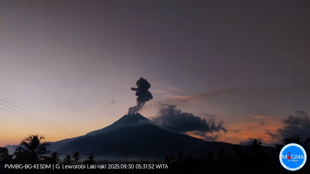
Indonesia , Lewotobi Laki-laki :
An eruption of Mount Lewotobi Laki-laki occurred on Tuesday, September 30, 2025, at 5:17 p.m. (local time). An ash column was observed about 2,000 m above the summit (about 3,584 m above sea level). The ash column was gray and dense, oriented toward the west and northwest. This eruption was recorded by seismograph with a maximum amplitude of 22.2 mm and a duration of 176 seconds.
VOLCANO OBSERVATORY NOTICE FOR AVIATION – VONA
Issued : September 30 , 2025
Volcano : Lewotobi Laki-laki (264180)
Current Aviation Colour Code : ORANGE
Previous Aviation Colour Code : orange
Source : Lewotobi Laki-laki Volcano Observatory
Notice Number : 2025LWK472
Volcano Location : S 08 deg 32 min 20 sec E 122 deg 46 min 06 sec
Area : East Nusa Tenggara, Indonesia
Summit Elevation : 5069 FT (1584 M)
Volcanic Activity Summary :
Eruption with volcanic ash cloud at 09h17 UTC (17h17 local).
Volcanic Cloud Height :
Best estimate of ash-cloud top is around 11469 FT (3584 M) above sea level or 6400 FT (2000 M) above summit. May be higher than what can be observed clearly. Source of height data: ground observer.
Other Volcanic Cloud Information :
Ash cloud moving from west to northwest. Volcanic ash is observed to be gray. The intensity of volcanic ash is observed to be thick.
Remarks :
Eruption recorded on seismogram with maximum amplitude 22.2 mm and maximum duration 176 second.
Source et photo : PVMBG
Colombia , Chiles/ Cerro Negro :
San Juan de Pasto, September 30, 2025, 4:10 p.m.
Regarding the monitoring of the activity of the Chiles-Cerro Negro Volcanic Complex (CVCCN), the Colombian Geological Survey (SGC), an entity affiliated with the Ministry of Mines and Energy,
reports that:
From September 23 to 29, 2025, the main variations in the monitored parameters compared to the previous week were:
● Seismic activity and energy release decreased compared to the previous week. Seismicity associated with rock fracturing within the volcanic edifice continued to predominate, followed by seismicity related to fluid dynamics.
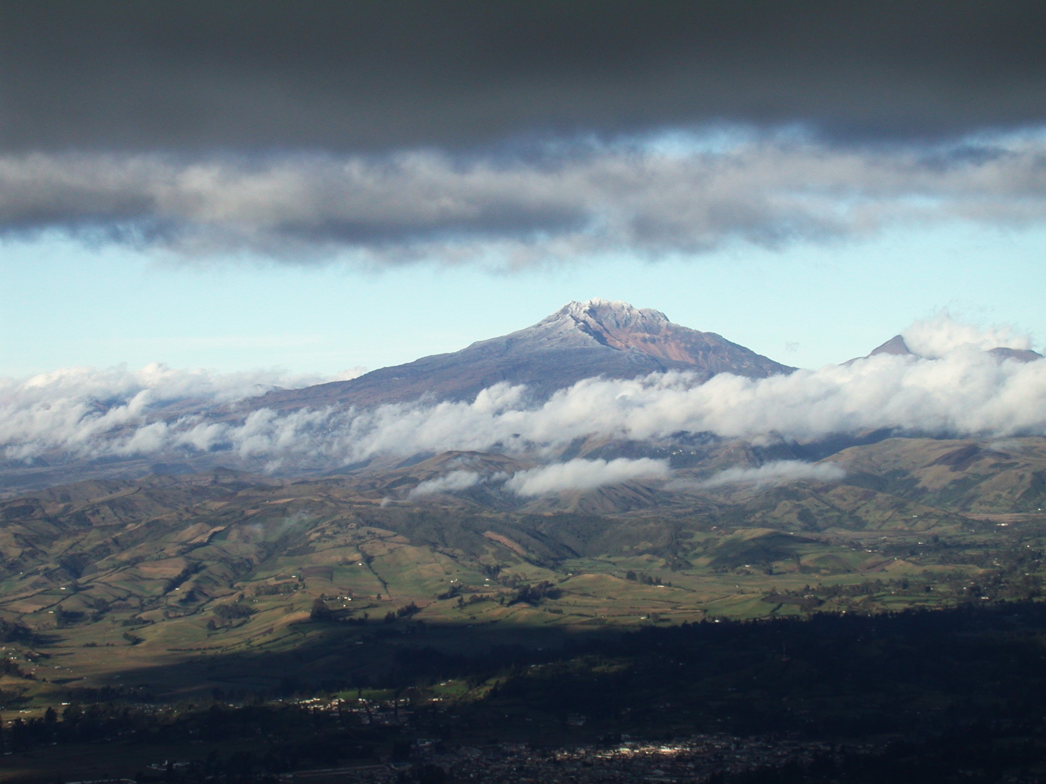
● Regarding seismic activity, the majority of localized earthquakes were concentrated primarily at the summit of Chiles Volcano, within the collapse zone, located within a radius of 1.0 km, at depths between 1.0 and 5.0 km from its summit (4,700 m above sea level), and with a maximum magnitude of 1.6. The remaining seismic activity was located scattered throughout the CVCCN’s area of influence, at depths between 0.3 and 4.2 km.
● Analysis of information obtained from satellite sensors and ground stations continues to indicate variations related to deformation processes in the volcanic area.
Based on the assessment and correlation of monitored parameters, the SGC recommends closely monitoring their developments through weekly bulletins and other information published through our official channels, as well as instructions from local and departmental authorities and the National Disaster Risk Management Unit (UNGRD).
Volcanic activity remains on yellow alert: active volcano with changes in the baseline behavior of monitored parameters and other manifestations.
Source et photo : SGC.