August 26 , 2025.
Alaska , Shishaldin :
AVO/USGS Volcanic Activity Notice
Current Volcano Alert Level: ADVISORY
Previous Volcano Alert Level: NORMAL
Current Aviation Color Code: YELLOW
Previous Aviation Color Code: GREEN
Issued: Monday, August 25, 2025, 11:48 AM AKDT
Source: Alaska Volcano Observatory
Notice Number: 2025/A516
Location: N 54 deg 45 min W 163 deg 58 min
Elevation: 9373 ft (2857 m)
Area: Aleutians
Volcanic Activity Summary:
Over the past month, signs of volcanic unrest at Shishaldin Volcano have been gradually increasing. Sulfur dioxide emissions have increased, a more vigorous vapor plume from the summit crater has been observed, and seismic and infrasound data have shown moderate increases in both the number of events and their amplitude.
These observations represent a departure from background behavior and the Aviation Color Code and Volcano Alert Level are thus being increased to YELLOW/ADVISORY.
An eruption is not certain, and this unrest could eventually decline over time. In the lead up to prior eruptions of Shishaldin, heat emissions were observed in satellite data as magma approached the floor of the summit crater. We have not detected elevated surface temperatures in the summit crater or observed anything else of significance, including during helicopter overflights by an AVO field crew on August 17 and 22, to indicate that magma is rising in the conduit.
Eruptions at Shishaldin are sometimes preceeded by days to weeks of seismic tremor (continuous shaking of the ground) that would provide warning of a possible explosive eruption.
Gas emissions from the summit crater have at times been mistaken by observers for ash emissions under certain viewing conditions (location of the sun relative to the observer), but there is no evidence for ash deposits on the snow around the summit crater in high resolution satellite data. The absense of ash deposits was confirmed by the close overflight observations of the summit crater made last week by an AVO field crew.
Local seismic and infrasound sensors, web cameras, and a geodetic network are used to monitor Shishaldin Volcano. In addition to the local monitoring network, AVO uses nearby geophysical networks, regional infrasound and lightning data, and satellite data to detect eruptions.
Recent Observations:
[Volcanic cloud height] typically less than 1000 ft above the summit
[Other volcanic cloud information] No ash emissions. Plume is steam and sulfur dioxide gas.
Remarks:
Shishaldin Volcano, located near the center of Unimak Island in the eastern Aleutian Islands, is a spectacular symmetric cone with a base diameter of approximately 10 miles (16 km). A 660 ft. (200 m) wide funnel-shaped summit crater typically emits a steam plume and occasional small amounts of ash. Shishaldin is one of the most active volcanoes in the Aleutian volcanic arc, with at least 54 episodes of unrest including over 26 confirmed eruptions since 1824. Most eruptions are relatively small, although activity during July–November, 2023 generated ash columns that reached between 30,000 ft (9 km) and 42,000 ft (13 km) above sea level.
Source et photo : AVO ( Capture d’écran )
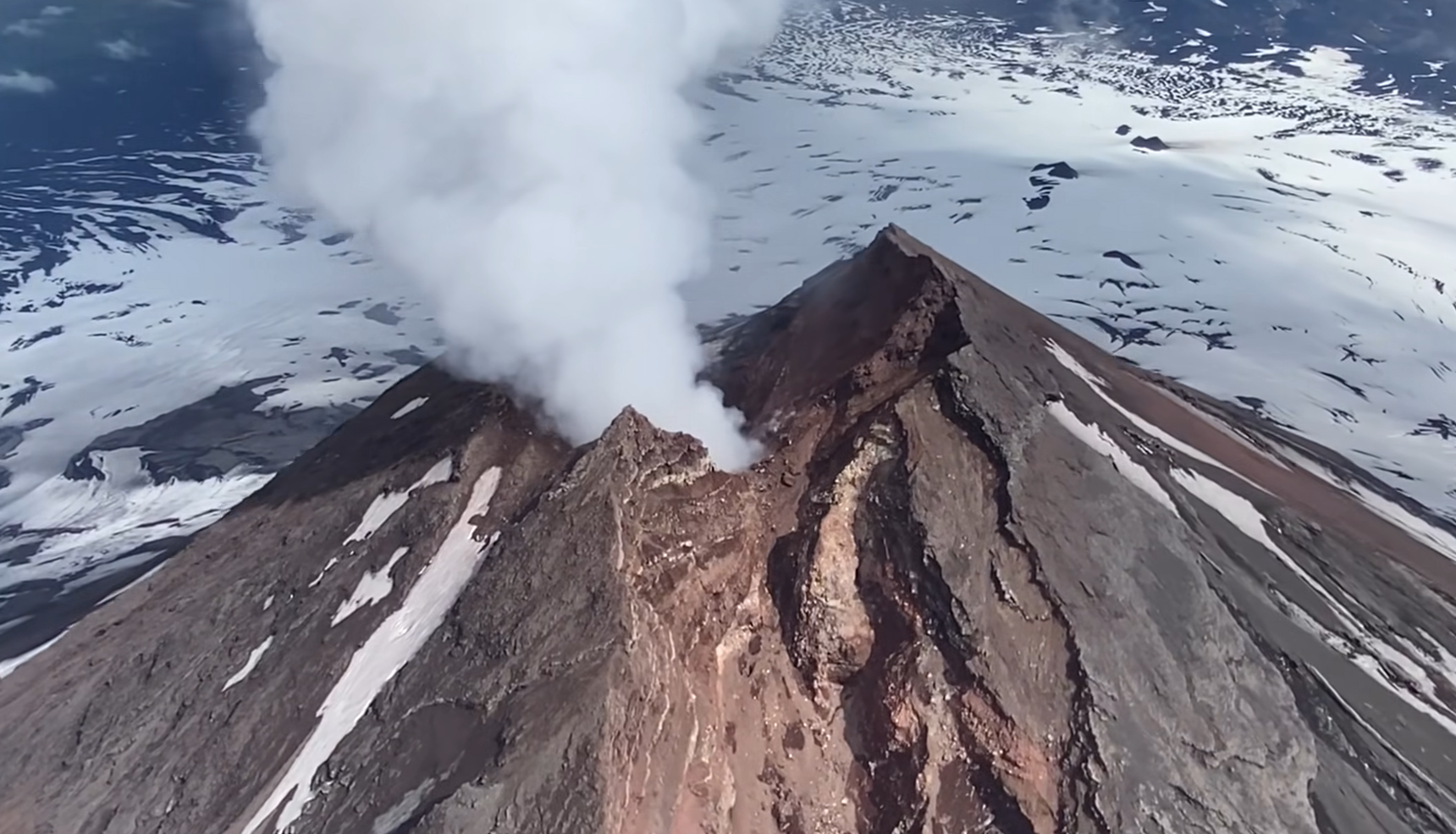
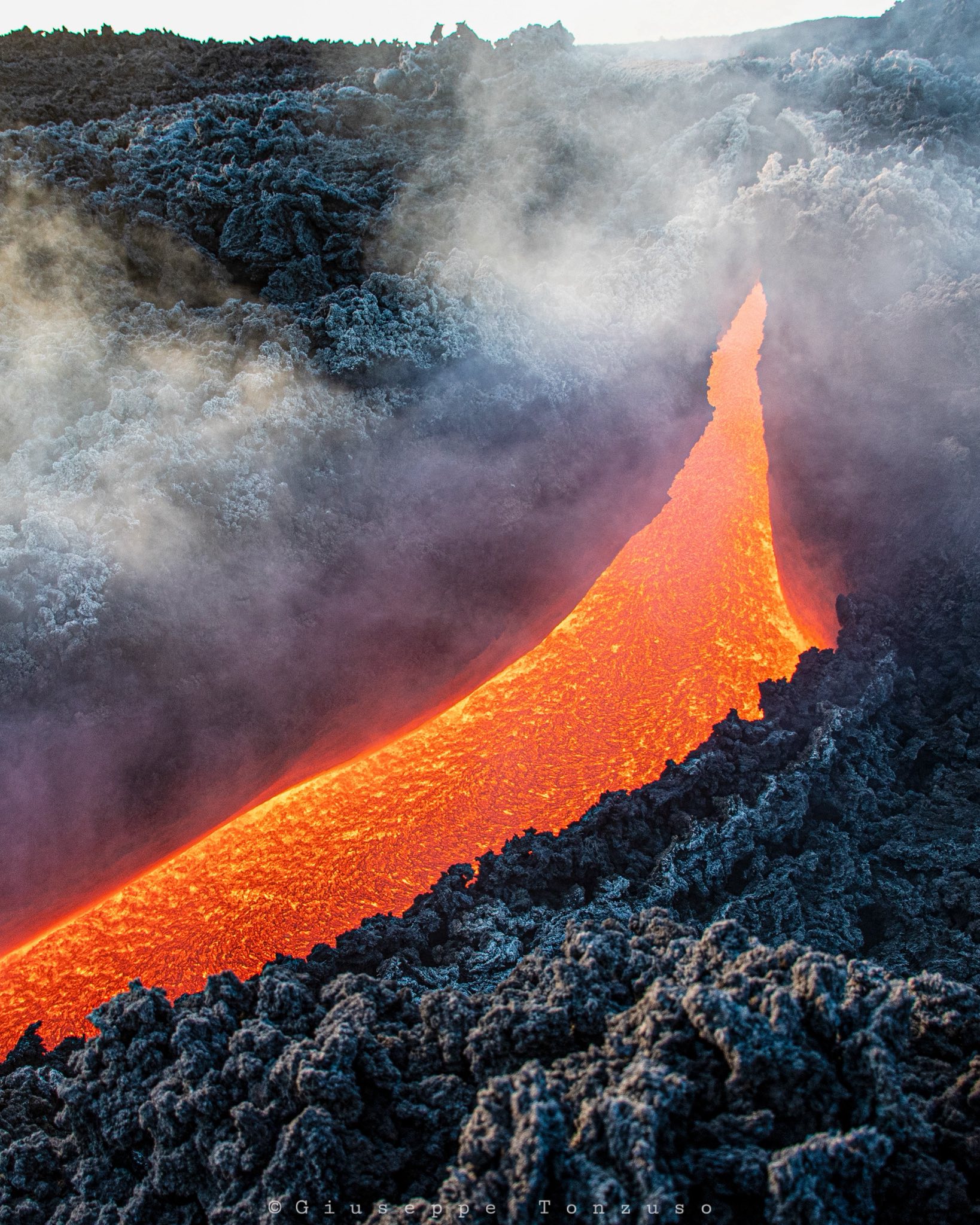
Italy / Sicily , Etna :
Etna Activity Update, August 25, 2025, 6:02 PM (16:02 UTC).
The National Institute of Geophysics and Volcanology, Osservatorio Etneo, reports that the effusive vent located at an altitude of 2,980 m has resumed feeding a southwestward-moving lava flow. Effusive activity continues from the vent located at an altitude of 3,100 m, which feeds a southwest-trending lava field, and from the vent located at an altitude of 3,200 m, on the southern flank of the Southeast Crater, which feeds a lava field composed of several southwest- and south-trending branches. Strombolian activity continues in the Southeast Crater, with pyroclastic fallout outside the crater rim. Sporadic low emissions of volcanic ash were also observed in the Southeast Crater, rapidly dispersed by high-altitude winds.
From a seismic perspective, after the decrease phase reported in the previous update, the average tremor amplitude began to gradually increase around 21:30 UTC yesterday, remaining in the high-value range. The centroid of the tremor sources remains located in the Southeast Crater area, at an altitude of approximately 3,000 meters above sea level. Infrasound activity, although discontinuous, has shown a slight decrease since the early hours of the day. The events, characterized by low and medium amplitude, are located in the Southeast Crater.
Ground deformation signals recorded by GNSS (HF) and inclinometer networks currently show no significant variation. The DRUV dilatometer station continues to display a slow variation in decompression, accumulating a total of approximately -35 nano-strains since the start of the current effusive activity.
Updates will be provided shortly.
Source : INGV
Photo : Giuseppe Tonzuso
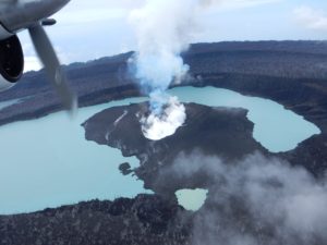
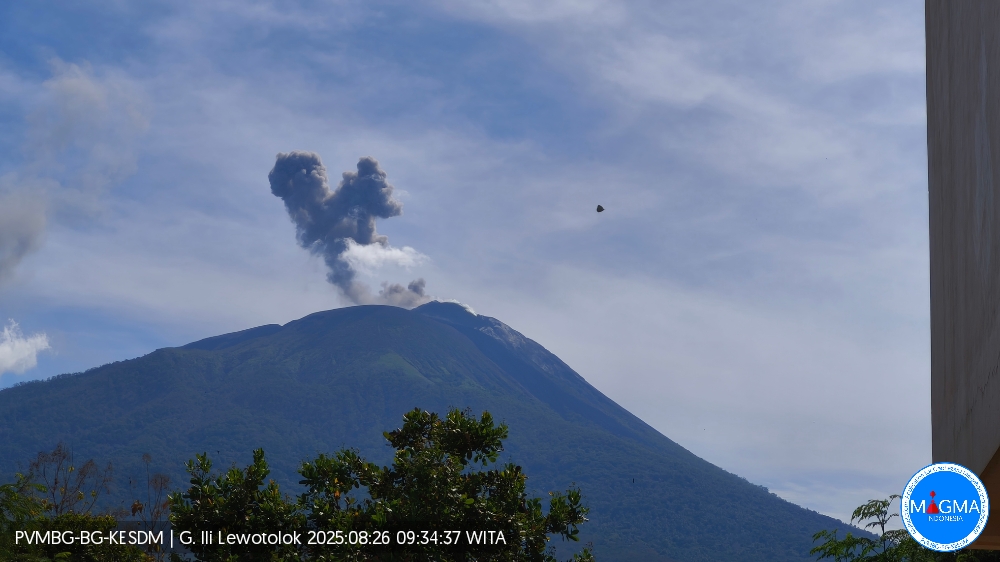
Indonesia , Ili Lewotolok :
An eruption of Mount Ili Lewotolok occurred on Tuesday, August 26, 2025, at 9:33 a.m. WITA. An ash column was observed about 600 m above the summit (about 2,023 m above sea level). The ash column was gray, of moderate intensity, and directed westward. This eruption was recorded by seismograph with a maximum amplitude of 7.8 mm and a duration of 48 seconds.
VOLCANO OBSERVATORY NOTICE FOR AVIATION – VONA
Issued : August 26 , 2025
Volcano : Ili Lewotolok (264230)
Current Aviation Colour Code : ORANGE
Previous Aviation Colour Code : orange
Source : Ili Lewotolok Volcano Observatory
Notice Number : 2025LEW053
Volcano Location : S 08 deg 16 min 19 sec E 123 deg 30 min 18 sec
Area : East Nusa Tenggara, Indonesia
Summit Elevation : 4554 FT (1423 M)
Volcanic Activity Summary :
Eruption with volcanic ash cloud at 01h33 UTC (09h33 local).
Volcanic Cloud Height :
Best estimate of ash-cloud top is around 6474 FT (2023 M) above sea level or 1920 FT (600 M) above summit. May be higher than what can be observed clearly. Source of height data: ground observer.
Other Volcanic Cloud Information :
Ash cloud moving to west. Volcanic ash is observed to be gray. The intensity of volcanic ash is observed to be medium.
Remarks :
Eruption recorded on seismogram with maximum amplitude 7.8 mm and maximum duration 48 second.
Source et photo : Magma Indonésie .
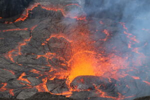
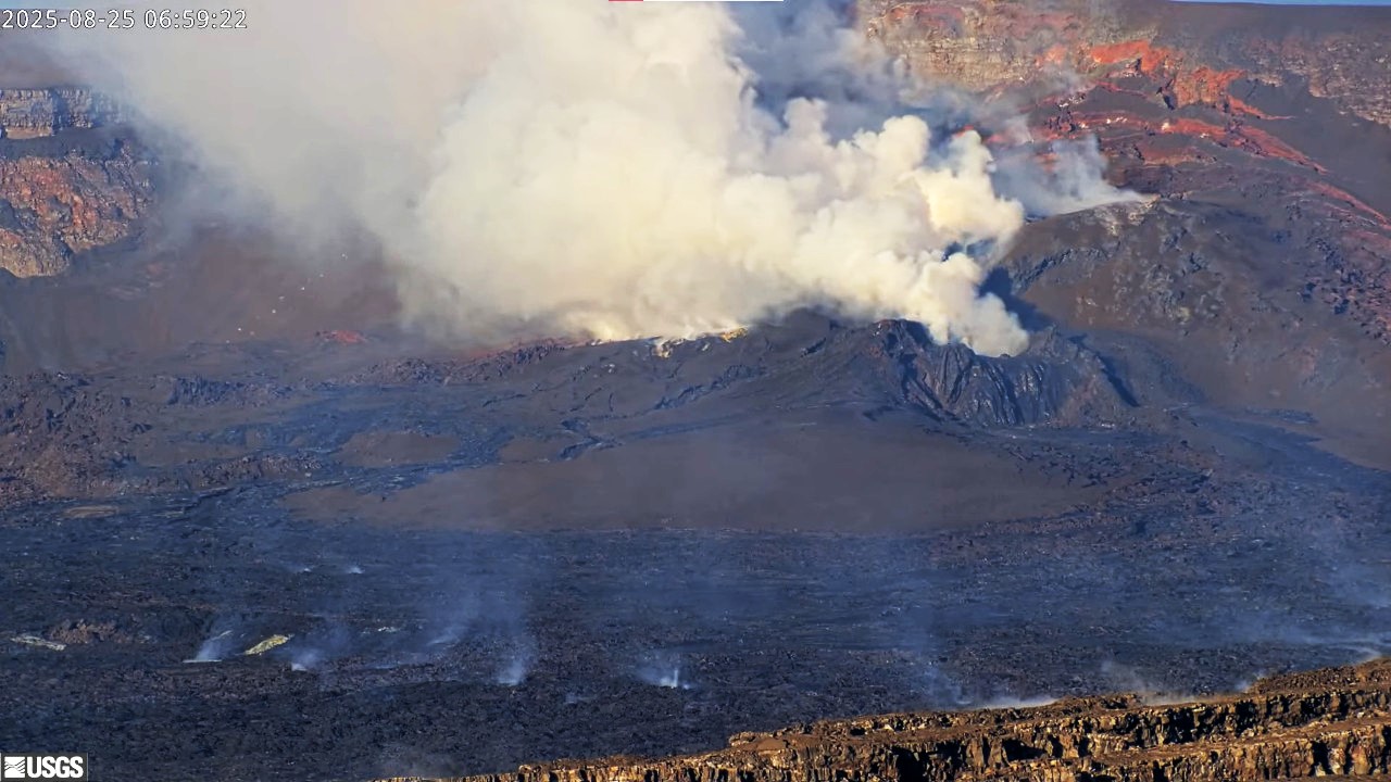
Hawaii , Kilauea :
HAWAIIAN VOLCANO OBSERVATORY DAILY UPDATE , U.S. Geological Survey
Monday, August 25, 2025, 12:49 PM HST (Monday, August 25, 2025, 22:49 UTC)
19°25’16 » N 155°17’13 » W,
Summit Elevation 4091 ft (1247 m)
Current Volcano Alert Level: WATCH
Current Aviation Color Code: ORANGE
Activity Summary:
Episode 31 of the ongoing Halemaʻumaʻu eruption ended abruptly at 2:52 a.m. HST on August 23 after 12.6 hours of continuous fountaining. Weak glow was present in the north vent overnight. Episode 32 is likely to begin in the first week of September or later if there are unexpected changes in the inflation rate.
Summit Observations:
Lava flows from episode 31 covered more than 75% of the floor of Halemaʻumaʻu within the southern part of Kaluapele (Kīlauea caldera) and continued to show incandescence overnight.
The Uēkahuna tiltmeter (UWD) recorded about 22 microradians of deflationary tilt during this episode. The end of the eruption was coincident with a rapid change from deflation to inflation at the summit and a decrease in seismic tremor intensity. The Uēkahuna tiltmeter (UWD) has recorded approximately 7.9 microradians of inflationary tilt since the episode ended. Patterns of tremor indicate that gas pistoning is continuing deeper within the vent and is marked by low frequency bursts every 2-5 minutes.
Elevated degassing continues from the vent. Average sulfur dioxide (SO2) emission rates during inter-episode pauses are typically 1,200 to 1,500 t/d, though emission rates vary on short time scales in association with gas-pistoning.
Strands of volcanic glass known as Pele’s hair are present throughout the summit area of Hawaiʻi Volcanoes National Park and surrounding communities and can be remobilized by wind even after fountaining has ceased.
Rift Zone Observations:
Rates of seismicity and ground deformation remain very low in the East Rift Zone and Southwest Rift Zone, with no significant earthquake activity in the past 24 hours outside of the summit. Sulfur dioxide (SO2) emissions from the East Rift Zone remain below the detection limit.
Source et photo : USGS.
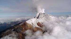
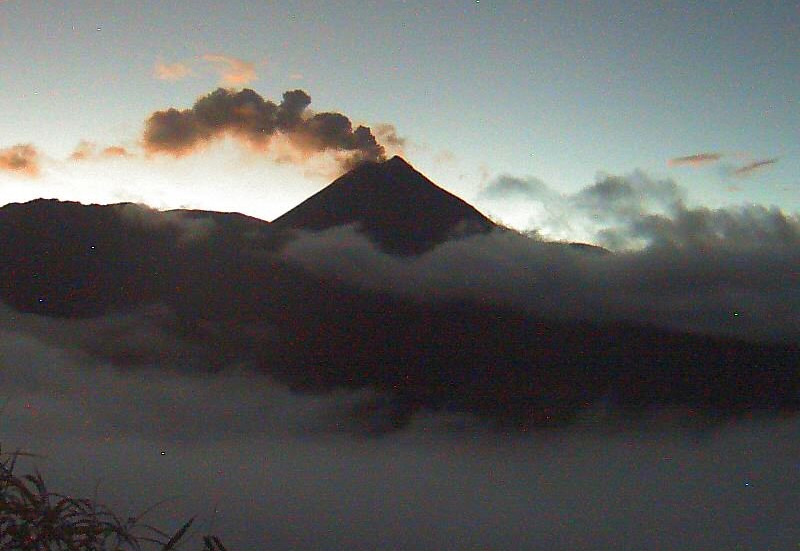
Ecuador , El Reventador :
DAILY STATUS REPORT OF REVENTADOR VOLCANO, Monday, August 25, 2025.
Information Geophysical Institute – EPN.
Surface Activity Level: High, Surface Trend: No Change
Internal Activity Level: Moderate, Internal Trend: Descending
From August 24, 2025, 11:00 a.m. to August 25, 2025, 11:00 a.m.:
Seismicity:
Below is the count of seismic events recorded at the reference station.
Explosion (EXP) 63
Long Period (LP) 13
Emission Tremor (TREMI) 8
Harmonic Tremor (TRARM) 5
Rainfall/Lahars:
Since yesterday afternoon, rainfall has been recorded in the volcanic area, but it has not generated mudflows or debris flows. *Heavy rainfall could remobilize accumulated material, generating mudflows and debris flows that would cascade down the volcano’s flanks and flow into adjacent rivers.*
Emission Column/Ash:
Yesterday afternoon, surveillance cameras recorded several ash columns in northwest and southwest directions, at heights between 400 and 800 meters above the crater. Regarding this activity, the Washington-based VAAC agency issued two reports of ash clouds reaching 700 meters above the crater, moving westward.
Other monitoring parameters:
The MIROVA-VIIRS 375 satellite system recorded one thermal anomaly, the MIROVA-VIIRS 750 satellite system one thermal anomaly, and the FIRMS satellite system five thermal anomalies over the past 24 hours.
Observation:
Despite cloud cover in the volcanic area, surveillance cameras observed several episodes of incandescent material falling on the volcano’s flanks, up to 1,000 meters below the crater level, last night and early this morning. At the time of writing, the volcano remains entirely cloudy.
Alert Level – SGR: Orange
Source : IGEPN
Photo : archive igepn