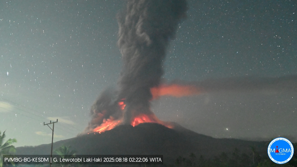
August 18 , 2025.
Indonesia , Lewotobi Laki-laki :
An eruption occurred at Mount Lewotobi Laki-laki on Monday, August 18, 2025, at 2:21 a.m. (local time). The observed ash column rose about 8,000 m above the summit (about 9,584 m above sea level). The ash column was gray and dense, oriented toward the west and northwest. At the time of writing, the eruption was still ongoing.
VOLCANO OBSERVATORY NOTICE FOR AVIATION – VONA
Issued : August 18 , 2025
Volcano : Lewotobi Laki-laki (264180)
Current Aviation Colour Code : RED
Previous Aviation Colour Code : red
Source : Lewotobi Laki-laki Volcano Observatory
Notice Number : 2025LWK370
Volcano Location : S 08 deg 32 min 20 sec E 122 deg 46 min 06 sec
Area : East Nusa Tenggara, Indonesia
Summit Elevation : 5069 FT (1584 M)
Volcanic Activity Summary :
Eruption with volcanic ash cloud at 18h21 UTC (02h21 local).
Volcanic Cloud Height :
Best estimate of ash-cloud top is around 30669 FT (9584 M) above sea level or 25600 FT (8000 M) above summit. May be higher than what can be observed clearly. Source of height data: ground observer.
Other Volcanic Cloud Information :
Ash cloud moving from west to northwest. Volcanic ash is observed to be gray. The intensity of volcanic ash is observed to be thick.
Remarks :
Eruption recorded on seismogram with maximum amplitude 47.3 mm and maximum duration 321 second.
Source et photo : Magma Indonésie .
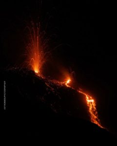
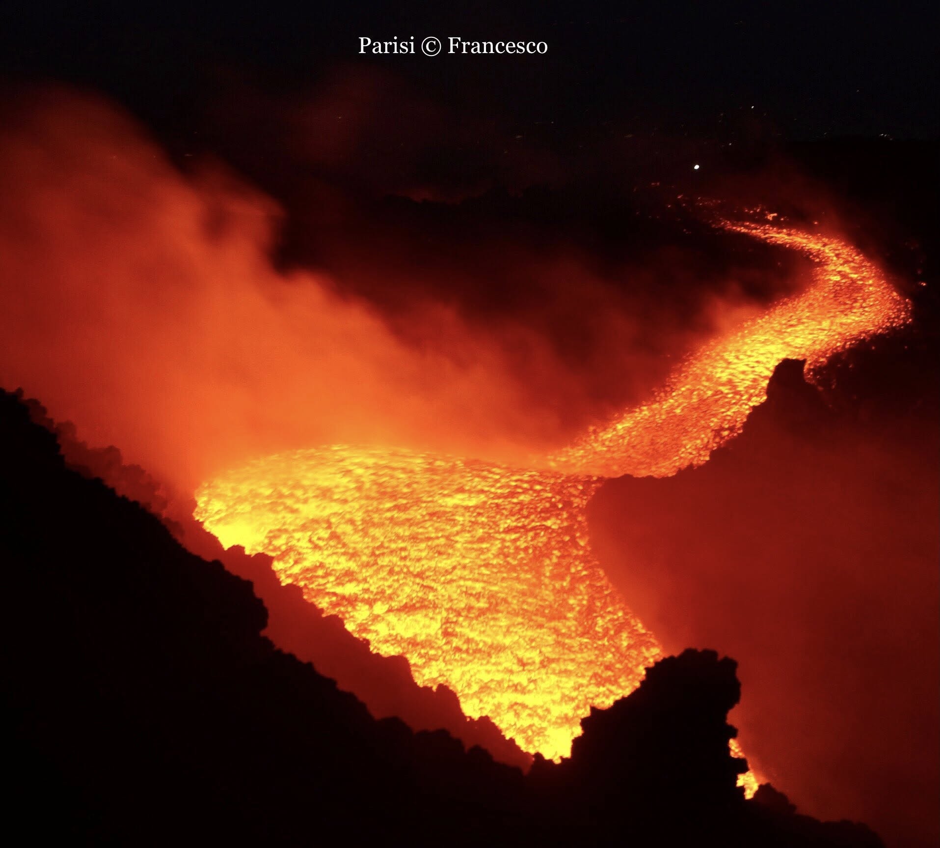
Italy / Sicily , Etna :
Etna Activity Update, August 16, 2025, 7:45 PM (5:45 PM UTC).
The Etna Observatory, National Institute of Geophysics and Volcanology, reports that, based on analysis of satellite images and volcanological observations, the lava flow at 9:40 GMT was still active, spreading slowly southward. The most advanced front was located at an altitude of approximately 2,450 meters.
Moderate explosive activity continued in the southeast crater, with varying intensity.
Volcanic tremor remained average, with its sources located just north of the Southeast Crater, at approximately 3,000 meters above sea level.
Infrasound activity was moderate, with events mainly located in the Southeast Crater. Weather conditions could affect the counting and localization of infrasound events.
Signals from tiltmeter and deformation meter networks for ground deformation monitoring show no significant changes.
Further updates will be provided shortly.
Source : INGV
Photo : Francesco Parisi / FB.
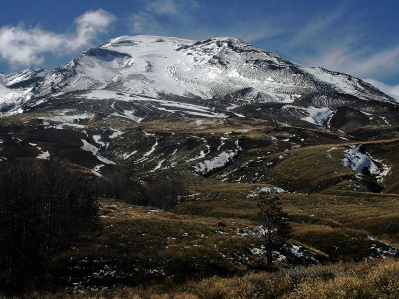
Chile , Puyehue / Cordon Caulle :
Seismology
The seismological activity during this period was characterized by:
228 VT-type earthquakes, associated with rock fracturing (volcano-tectonics). The most energetic earthquake, with a local magnitude (LM) of 2.5, occurred 4.4 km south-southwest of the volcanic edifice, at a depth of 4.5 km from the 2011 emission center.
8 LP-type earthquakes, associated with fluid dynamics within the volcanic system (long period). The most energetic earthquake had a reduced displacement (RD) of 6.7 cm².
2 TO-type earthquakes, associated with fluid dynamics within the volcanic system, characterized by their distinctive waveform (Tornillo). The most powerful earthquake (RD) measured 12.3 cm².
Fluid Geochemistry
No anomalies in atmospheric sulfur dioxide (SO2) emissions have been reported in the area near the volcanic complex, according to data published by the Tropospheric Monitoring Instrument (TROPOMI) and the Sulfur Dioxide Group of the Ozone Monitoring Instrument (OMI).
Geodesy
The geodetic activity for the period was characterized by:
– The continuation of the inflationary process in the graben area, northwest of the emission center in 2011, with a slight increase in uplift rates, reaching a maximum of 0.80 cm/month.
This process was observed in previous years, suggesting a seasonal process that does not affect the trend recorded since 2021, adjusted for uplift rates of 13 cm/year.
– The continuation of the deflationary process in the area of the 2011 emission center. This process has been observed since the installation of GNSS stations in the area and has experienced a deflation rate with maximums exceeding -2.0 cm/month, which is considered a high magnitude.
– According to the deformation models obtained by the geodesy group, two distinct sources of deformation could be suggested: one in the graben area, which would respond to deeper processes, and the other in the area of the 2011 emission center, which would respond to a more superficial and localized process in this area.
These behaviors reflect the expected dynamics of the volcanic system, with seasonal variations without significant alterations to the long-term trend.
Satellite Thermal Anomalies
During the period, low-power thermal anomalies were recorded in the area where the laccolith is located, northeast of the 2011 emission center. These recorded a maximum volcanic radiative power (VRP) of 1.8 MW on July 23, according to data processed by the VIIRS 750 and VIIRS 375 sensors of the Mid-Infrared Volcanic Activity Observation Platform (MIROVA). Sentinel 2-L2A and Landsat 8-9 satellite images did not detect any.
During this period, the volcanic complex continued to show signs of activity, evidenced by deformation processes: inflationary in the trench area and deflationary near the 2011 emission center. This deformation is accompanied by low-energy volcanic seismicity, the variations of which remain within the limits considered normal for the system.
In view of the above, the Volcanic Technical Alert remains in effect:
YELLOW TECHNICAL ALERT: Changes in the behavior of volcanic activity.
Source : Sernageomin
Photo : Huella Andina Expeditions
Guatemala , Santiaguito :
THE CONRED SYSTEM REPORTS SANTIAGUITO VOLCANO ACTIVITY
Written by Media Monitoring on August 16, 2025.
According to the Special Volcanological Bulletin (BESAN 075-2025) published by INSIVUMEH, pyroclastic density currents are descending from the western rim of the Santiaguito volcano dome and moving toward the southwest flank. This activity is associated with the collapse of material accumulated on the volcanic complex, following the course of the San Isidro River and the lava flow active since 2022. This pyroclastic flow has moved over a distance of 4 km.
These currents could continue in the coming weeks or months.
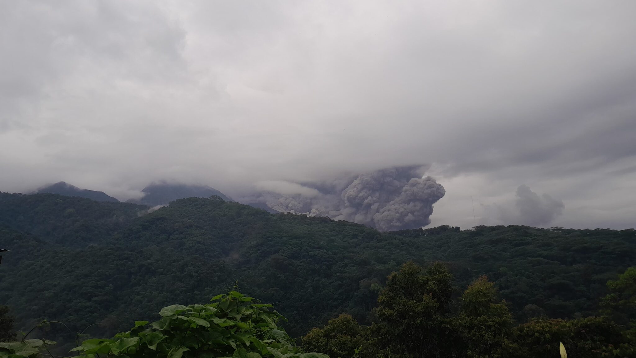
Additionally, gas and ash clouds are observed rising up to 1,000 meters in altitude and moving west and southwest, carried by the wind, over distances of between 30 and 60 kilometers.
Ashfall has been reported in communities such as San Marcos Palajunoj, Loma Linda, San Martín Sacatepéquez, and Colomba, as well as fine particle fall in more remote areas such as La Reforma, El Quetzal, Coatepeque, and Pajapita.
Through disaster reduction coordinators at various levels, in coordination with INSIVUMEH, volcanic activity is being continuously monitored, in accordance with established response plans and protocols.
Recommendations for the public:
If you live in an area affected by ashfall, cover water tanks, wear a mask, and avoid outdoor activities.
Stay informed through the official CONRED and INSIVUMEH accounts.
Follow the instructions of local authorities and prepare your family response plan.
Source et photo : Conred
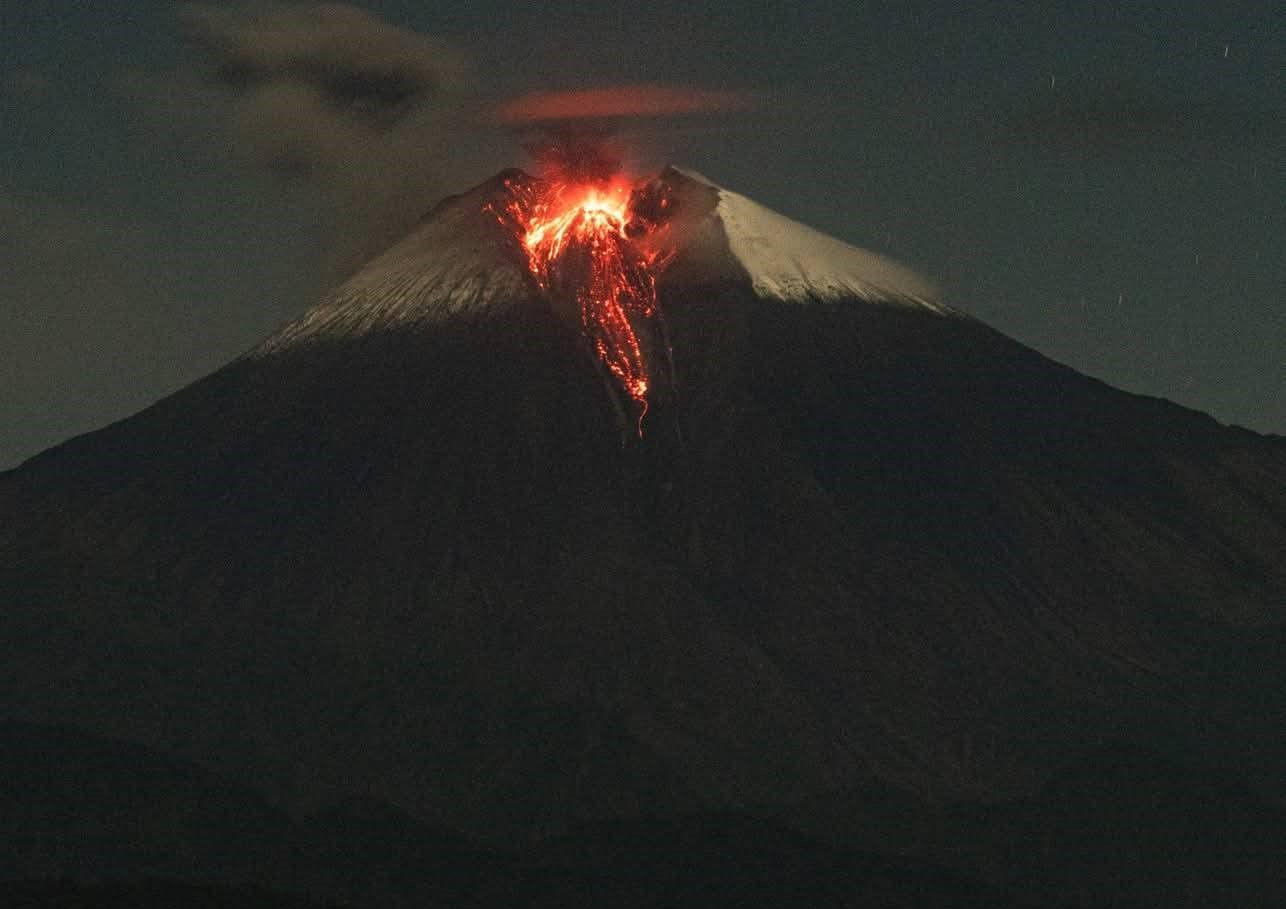
Ecuador , Sangay :
DAILY STATUS REPORT OF SANGAY VOLCANO, Sunday, August 17, 2025.
Information Geophysical Institute – EPN.
Surface Activity Level: High, Surface Trend: Descending
Internal Activity Level: Moderate, Internal Trend: No Change
Seismicity: From August 16, 2025, 11:00 a.m. to August 17, 2025, 11:00 a.m.:
Seismicity:
Below is the count of seismic events recorded at the reference station.
Explosion (EXP): 74
Rainfall/Lahars:
No rainfall has been recorded in the volcanic area. **Heavy rainfall could remobilize accumulated material, generating mud and debris flows that would cascade down the volcano’s flanks and flow into adjacent rivers.**
Emissions/Ash Plume:
Over the past 24 hours, several gas and ash emissions were observed by surveillance cameras at an altitude between 300 and 2,000 meters above the crater, in a southwesterly direction. Regarding this activity, the Washington-based VAAC agency has published two reports of ash emissions, at an altitude between 870 meters above the crater, in a west and southwesterly direction.
Gas:
The MOUNTS satellite system reported 25.5 tons of sulfur dioxide (SO2), measured on 08/16/2025 at 1:33 PM LT.
Other monitoring parameters:
Over the past 24 hours, the FIRMS satellite system recorded 15 thermal anomalies. The MIROVA-MODIS satellite system recorded one thermal anomaly, while MIROVAVIIRS (375 and 750) recorded two, respectively.
Observation:
During last night and early this morning, several episodes of incandescent material falling up to 1,400 meters below the crater level were recorded. In addition, the volcano remained partially or completely cloudy.
Alert level: Yellow
Source : IGEPN
Photo : Cristopher Cárdenas , 12/06/2025