August 15 , 2025.
Italy / Sicily , Etna :
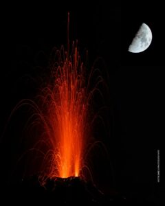
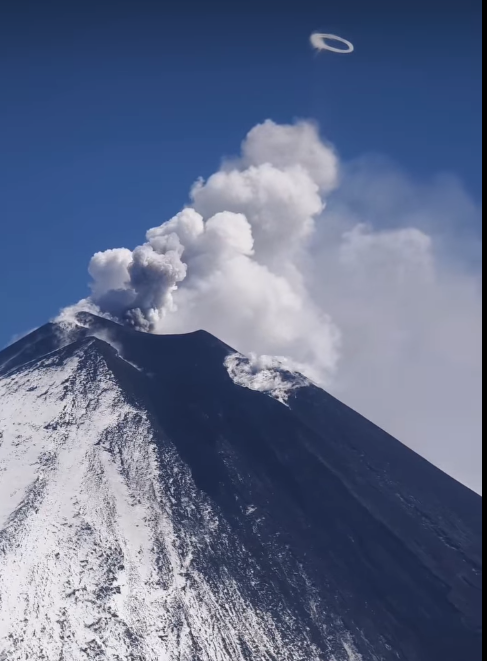
Etna Activity Report, August 14, 2025, 12:13 PM (10:13 UTC).
The National Institute of Geophysics and Volcanology, Osservatorio Etneo, reports that during field surveys currently being carried out by INGV personnel, it has been observed
that the vent is located between the Bocca Nuova crater and the Southeast crater, at an estimated altitude of approximately 2,980 m above sea level. Although at a lower altitude, the current vent opened along the alignment delimited by the eruptive vents that fueled the February-March and August 10, 2025, vents located at 3,100 m and 3,050 m above sea level, respectively.
Currently, the lava flow is moderately active, and explosive activity is underway in the Southeast Crater. Ejected lava fragments are falling on the crater rim and, sporadically, along the cone slopes.
Volcanic tremor remains at average values, with an increasing trend.
The sources are located at approximately 3,000 m altitude, near the Southeast Crater.
Infrasound activity remains moderate and localized near the Northeast Crater.
Signals from ground deformation monitoring networks show no significant changes.
Updates will be provided shortly.
Source : INGV.
Photo : Etna Walk / Giuseppe Distefano/ FB .
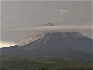
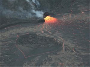
Kamchatka , Klyuchevskoy :
VOLCANO OBSERVATORY NOTICE FOR AVIATION (VONA)
Issued: August 15 , 2025
Volcano: Klyuchevskoy (CAVW #300260)
Current aviation colour code: RED
Previous aviation colour code: orange
Source: KVERT
Notice Number: 2025-77
Volcano Location: N 56 deg 3 min E 160 deg 38 min
Area: Kamchatka, Russia
Summit Elevation: 4750 m (15580 ft)
Volcanic Activity Summary:
A summit explosive-effusive eruption of the volcano continues. Video and satellite data by KVERT showed explosions sent ash up to 9 km a.s.l., and ash plume is extending for 35 km to the north-east of the volcano.
An explosive-effusive eruption of the volcano continues. The danger of ash explosions up to 10 km (32,800 ft) a.s.l. remains. Ongoing activity could affect international and low-flying aircraft.
Volcanic cloud height:
9000 m (29520 ft) AMSL Time and method of ash plume/cloud height determination: 20250815/0330Z – Video data
Other volcanic cloud information:
Distance of ash plume/cloud of the volcano: 35 km (22 mi)
Direction of drift of ash plume/cloud of the volcano: NE / azimuth 53 deg
Time and method of ash plume/cloud determination: 20250815/0340Z – Himawari-9 14m15
Source : Kvert
Photo : Vulcaniya / FB. (capture d’écran)
Guatemala , Agua :
Insivumeh confirms cracks at the summit of Agua Volcano; Conred issues a warning
Agua Volcano is showing signs of instability after weeks of earthquakes and rains that could trigger dangerous mudflows.
After a seismic sequence that left dozens of tremors in a month, Agua Volcano is showing cracks in its structure and signs of wear under the pressure of rain and tectonic activity. The threat is not eruptive, but it is dangerous: landslides, rockfalls, and mudflows could descend through eight vulnerable points, where hundreds of people live. According to the Special Volcanic Bulletin of Agua Volcano number 72, published by the National Institute of Seismology, Volcanology, Meteorology and Hydrology (Insivumeh), this volcano records multiple mass movements and fissures associated with the seismic sequence of Santa María de Jesús, Sacatepéquez, for which the authorities make several recommendations.
The bulletin states that the conditions of the most affected sites have been verified: Malpaso, Los Zanjones, La Piche, and La Bolsa, as well as the ascent route to the summit of the volcanic complex, affected by fissures in the ground and rockfalls. It adds that due to the rainy season, lahars could be recorded.
Seismic Sequence
The seismic sequence began on July 8, 2025, with a magnitude 5.2 earthquake, followed by another of magnitude 5.6, both with their epicenter in Sacatepéquez. Since then, dozens of earthquakes have been recorded, according to data from Insivumeh and Conred.
The scientific entity clarified that these events are of tectonic origin and are not related to volcanic activity. However, fissures and rockfalls have occurred around the Agua volcano. The activity is associated with the Jalpatagua fault and other geological structures parallel to the volcanic arc, in a region characterized by the interaction of the Cocos, Caribbean, and North American plates.
Insivumeh technicians explain that some of the rumbling noises heard by the population are due to a resonance effect in the volcano’s vents, but do not imply magmatic reactivation.
Conred points out that this area was the scene of similar seismic sequences in 2019, 2021, and 2024, although of shorter duration. Currently, constant monitoring is maintained, and preventive measures have been recommended against possible lahars due to the rainy season.
Sources : Prensa Libre , Conred .
Photo : César Pérez Marroquín
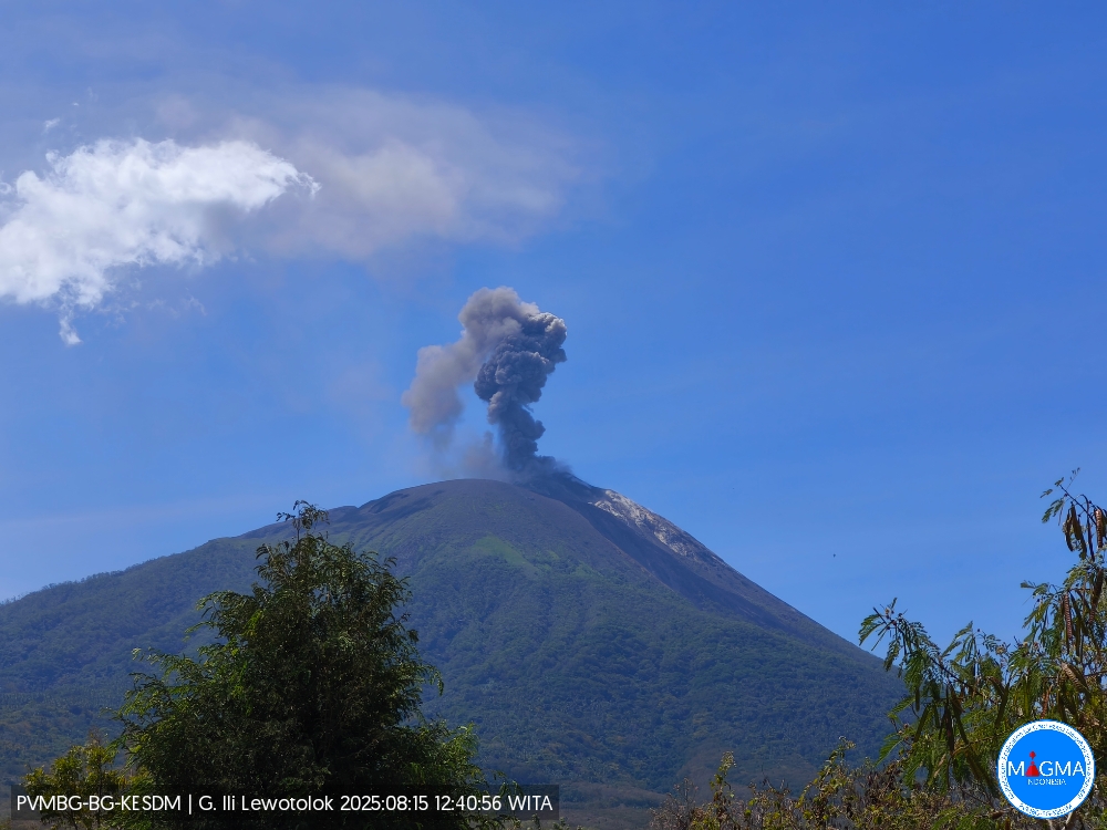
Indonesia , Ili Lewotolok :
An eruption of Mount Ili Lewotolok occurred on Friday, August 15, 2025, at 12:40 WITA. An ash column was observed about 500 m above the summit (about 1,923 m above sea level). The ash column was gray and of strong intensity, moving westward. This eruption was recorded by seismograph with a maximum amplitude of 32.9 mm and a duration of 35 seconds.
Seismic Observations
51 eruption earthquakes with amplitudes ranging from 6.7 to 26.9 mm and lasting from 29 to 59 seconds.
29 emission earthquakes with amplitudes ranging from 2 to 5.9 mm and lasting from 27 to 30 seconds.
1 non-harmonic tremor with amplitude of 4.1 mm and lasting 89 seconds.
Recommendations
At activity level III (SIAGA):
People living near Mount Ili Lewotolok, as well as visitors, mountaineers, and tourists, are advised to refrain from entering and carrying out activities within a 3 km radius of the activity center of Mount Ili Lewotolok. Be aware of the potential dangers of lava avalanches and pyroclastic flows originating from the south, southeast, west, and northeast sectors of Mount Ili Lewotolok.
The public is advised not to panic if they hear a rumbling or roaring noise coming from the crater of Mount Ili Lewotolok, as this noise is characteristic of volcanic activity during an eruption. This powerful rumbling can cause severe vibrations in several parts of the building, including windows and glass doors.
Source et photo : Magma Indonésie .
Colombia , Galeras :
San Juan de Pasto, August 12, 2025, 2:50 p.m.
Regarding the monitoring of the activity of the Galeras Volcano, the Colombian Geological Survey (SGC), an entity affiliated with the Ministry of Mines and Energy, reports that:
During the week of August 5 to 11, 2025, the main variations in the monitored parameters compared to the previous week were:
● In areas of low volcanic activity, an increase in seismic activity and a decrease in the released seismic energy were observed. The predominance of seismic activity associated with rock fracturing processes within the volcanic edifice continued. ● The earthquakes showed low energy levels and were mainly located near the main crater, at distances of less than 1.5 km, at depths of less than 3.0 km from the Galeras summit (4,200 m a.s.l.) and with magnitudes of less than 0.4. A few other events were scattered at distances between 5 and 19 km, at depths between 4 and 18 km, and with a maximum magnitude of 1.2.
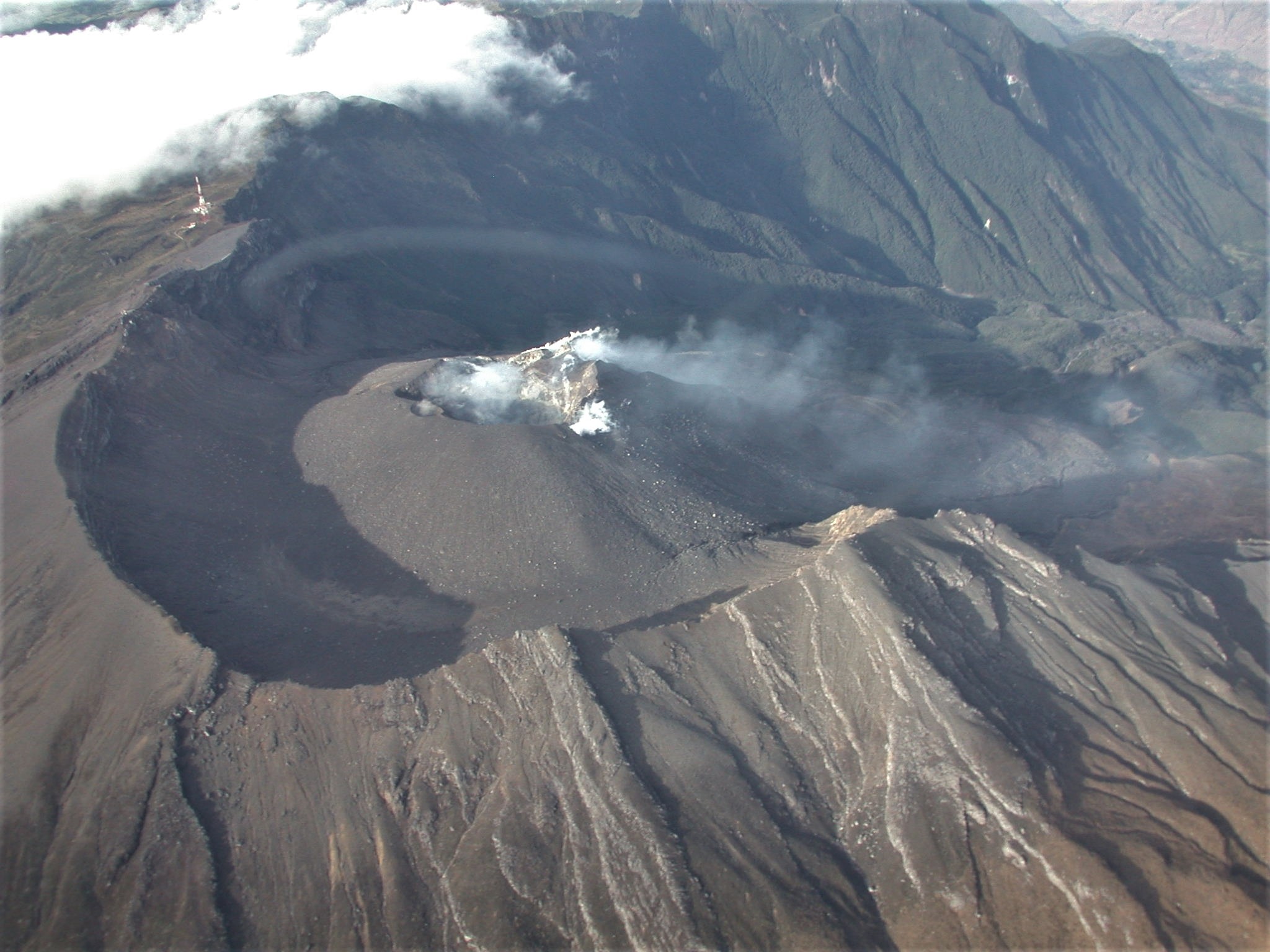
● During the week, low-altitude columns of white gas were observed, with variable dispersion depending on the wind, coming from the fumarole fields of El Paisita, to the north, and Las Chavas, to the west. Very low activity was detected at Deformes, located southeast of the active cone.
● Other volcanic monitoring parameters remained stable.
Based on the above, the SGC recommends closely monitoring developments through weekly bulletins and other information published through our official channels, as well as instructions from local and departmental authorities and the National Disaster Risk Management Unit (UNGRD).
Volcanic activity remains on yellow alert: active volcano with changes in the baseline behavior of monitored parameters and other manifestations.
Source et photo : SGC.