June 25 , 2025 .
Italy / Sicily , Etna :
WEEKLY BULLETIN, from June 16, 2025 to June 22, 2025 (publication date: June 24, 2025)
ACTIVITY STATUS SUMMARY
Based on monitoring data, the following points are highlighted:
1) VOLCANOLOGICAL OBSERVATIONS: Intense Strombolian activity at the Southeast Crater, with volcanic ash emission; variable-rate degassing activity at the Bocca Nuova, Voragine, and Northeast Craters.
2) SEISMOLOGICAL: Low seismic activity due to fracturing, with Ml > 2.0; tremor amplitude ranged from medium to low to high, similar to the lava fountaining event at the Southeast Crater. 3) INFRASOUND: Moderate infrasound activity
4) GROUND DEFORMATION: Ground deformation monitoring networks measured variations associated with the eruptive activity on June 19.
5) GEOCHEMISTRY: Average SO2 flux
CO2 flux from the ground (EtnaGas Network): Average to low values.
Dissolved CO2 in groundwater (EtnaAcque Network): No update.
Helium isotope ratio at peripheral sites: No update; the last data were at average values (June 4).
6) SATELLITE OBSERVATIONS: Thermal activity observed by satellite in the summit area was generally moderate, with high to very high values corresponding to the eruptive activity of the southeast crater on June 19, 2025.
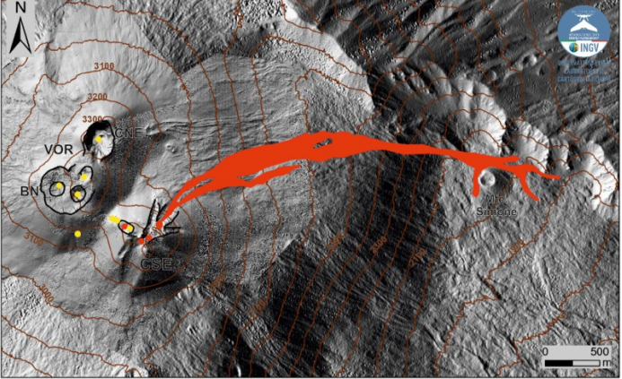
Map of the June 19th lava flow superimposed on the shaded relief of the summit area of Mount Etna, obtained from the processing of drone images acquired on June 4th. Geoidic contours are plotted every 100 meters.
CSE = Southeast Crater, CNE = Northeast Crater, VOR = Voragine, BN = Bocca Nuova.
VOLCANOLOGICAL OBSERVATIONS
During the week, volcanic activity in Mount Etna’s summit craters was monitored through the analysis of images acquired by surveillance cameras of the National Institute of Geophysics and Volcanology (INGV-OE), as well as through direct observations by INGV-OE personnel. However, adverse weather conditions limited the continuity of observations via the camera network. During the studied period, the Southeast Crater (CSE) showed intense Strombolian activity accompanied by volcanic ash emissions, while the Bocca Nuova (BN), Voragine (VOR) and Northeast (CNE) craters showed variable rate degassing activity.
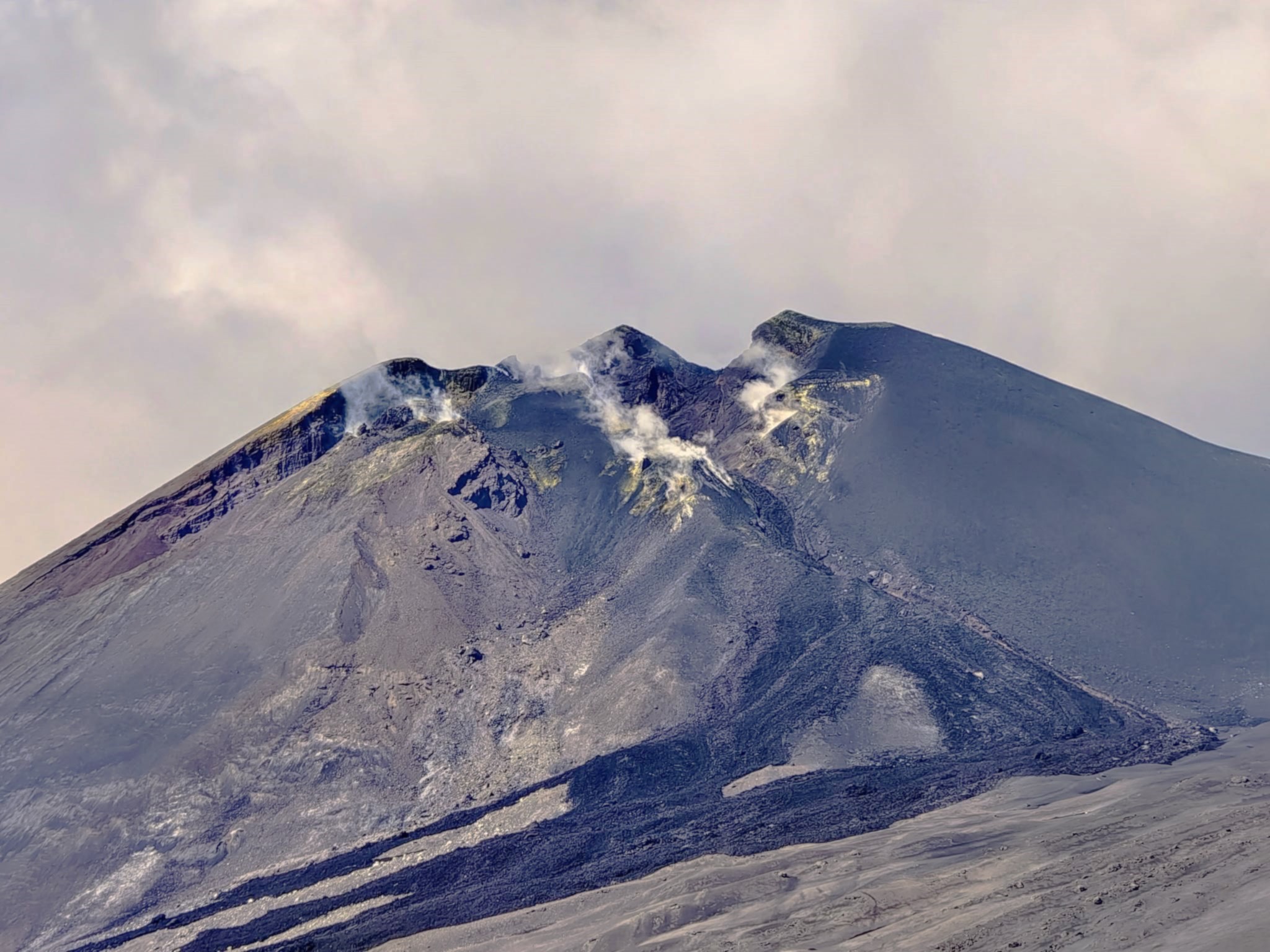
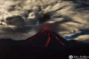
From 23:23 UTC on 18 June, the Southeast Crater (CSE) showed weak and discontinuous explosive activity, with a gradual increase in intensity over time. Although adverse weather conditions made observation discontinuous, images acquired by surveillance cameras allowed detecting an increase in the intensity of Strombolian activity between 10:00 and 11:00 UTC on 19 June. This activity generated a volcanic cloud which, in moments of visibility, reached an altitude estimated between 6,000 and 7,000 m above sea level, dispersing mainly towards the North. During a study carried out by the INGV-OE team, the presence of volcanic ash on the ground was detected in Randazzo. Low ash fallout was also reported in the municipality of Gioiosa Marea. Additionally, a lava flow was observed from the Southeast Crater, feeding a lava flow visible on cameras beginning around 3:55 UTC on June 19. The lava flow reached a height of approximately 1930 m above sea level, with a total length of 3.9 km, covering an area of approximately 6 × 10^5 m² and an estimated volume of 1.2 × 10^6 m³. These data are preliminary and subject to a margin of error of up to 40%.
During the week, due to adverse weather conditions, degassing activity of varying intensity was observed in the other summit craters. Beginning on June 21, images acquired by surveillance cameras highlighted the presence of intermittent lightning flashes inside the Northeast Crater (NEC).
Source : INGV .
Photos : INGV , Thor Luculus .
Italy , Stromboli :
WEEKLY BULLETIN, from June 16, 2025 to June 22, 2025 (publication date: June 24, 2025)
SUMMARY OF ACTIVITY STATUS
Based on monitoring data, the following points are highlighted:
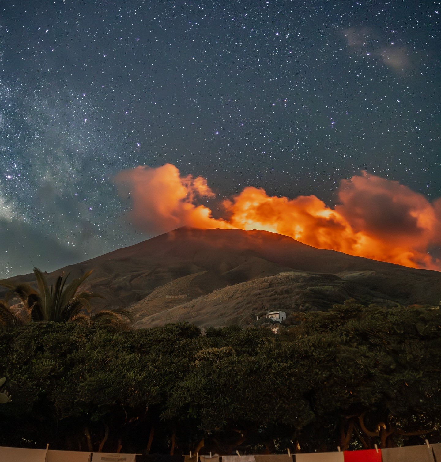
1) VOLCANOLOGICAL OBSERVATIONS: During the period studied, ordinary Strombolian eruptive activity was observed, accompanied by spattering in the northern zone. The total hourly frequency of explosions ranged from medium (9 events/hour) to high (16 events/hour).
The intensity was low and medium in both the northern and central-southern crater areas.
2) SEISMOLOGICAL: The monitored seismological parameters do not show any significant variations.
3) GROUND DEFORMATION: The ground deformation monitoring networks did not measure any significant variations. 4) GEOCHEMISTRY: SO2 flux: medium level.
CO2 flux from the soil in the Pizzo area (STR02) at high values.
C/S ratio in the plume: medium values.
Helium isotope ratio (R/Ra) dissolved in the thermal aquifer: no update.
Soil CO2 flux in the San Bartolo area: no update.
Soil CO2 flux in the Scari area: medium to high values.
5) SATELLITE OBSERVATIONS: Thermal activity observed by satellite in the summit area was generally of low intensity, with some moderate thermal anomalies.
VOLCANOLOGICAL OBSERVATIONS
During the observation period, Stromboli’s eruptive activity was characterized by analyzing images recorded by INGV-OE surveillance cameras located at an altitude of 190 m (SCT-SCV) and at Punta dei Corvi (SPCT). Explosive activity was mainly produced by four eruptive vents located in the North Crater area and by at least two vents located in the Central-South Crater area.
Observations of explosive activity recorded by surveillance cameras
In the North (N) Crater area, four active vents were observed, producing low-intensity explosive activity (the eruptive products reached a height of less than 80 m) and sometimes medium-intensity explosive activity (the height of the products ranged from 80 to 150 m). Furthermore, from June 20 to 22, intense and prolonged explosive activity was observed in the N1 sector. The eruptive products were mainly coarse materials (bombs and lapilli). The average explosion frequency ranged from 7 to 16 events/hour.
In the South-Central (SC) area, explosive activity was produced by at least two vents and was observed only during the first three days of the period (June 16–18); the explosions were mainly of low and medium intensity, with the emission of fine materials (ash) sometimes mixed with coarse materials (lapilli and bombs). The average explosion frequency ranged from 0 to 3 events/hour.
Source : INGV .
Photos : Stromboli stati d’animo / Sebastiano Cannavo .
Indonesia , Ibu :
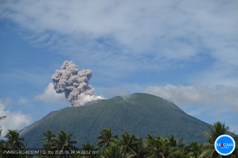
An eruption of G. Ibu occurred on Tuesday, June 24, 2025, at 2:28 PM WIT. The observed ash column was ± 600 m above the summit (± 1925 m above sea level). The ash column was gray and of strong intensity, oriented northeast. This eruption was recorded by seismograph with a maximum amplitude of 28 mm and a duration of 61 seconds.
VOLCANO OBSERVATORY NOTICE FOR AVIATION – VONA
Issued : June 25 , 2025
Volcano : Ibu (268030)
Current Aviation Colour Code : ORANGE
Previous Aviation Colour Code : orange
Source : Ibu Volcano Observatory
Notice Number : 2025IBU868
Volcano Location : N 01 deg 29 min 17 sec E 127 deg 37 min 48 sec
Area : North Maluku, Indonesia
Summit Elevation : 4240 FT (1325 M)
Volcanic Activity Summary :
Eruption with volcanic ash cloud at 05h28 UTC (14h28 local).
Volcanic Cloud Height :
Best estimate of ash-cloud top is around 6160 FT (1925 M) above sea level or 1920 FT (600 M) above summit. May be higher than what can be observed clearly. Source of height data: ground observer.
Other Volcanic Cloud Information :
Ash cloud moving to northeast. Volcanic ash is observed to be gray. The intensity of volcanic ash is observed to be thick.
Remarks :
Eruption recorded on seismogram with maximum amplitude 28 mm and maximum duration 61 second.
Source et photo : Magma Indonésie .
Colombia , Chiles / Cerro Negro :
San Juan de Pasto, June 24, 2025, 4:40 p.m.
Regarding the monitoring of the activity of the Chiles-Cerro Negro Volcanic Complex (CVCCN), the Colombian Geological Survey (SGC), an entity affiliated with the Ministry of Mines and Energy, reports that:
From June 17 to 23, 2025, the main variations in the monitored parameters compared to the previous week were:
● A decrease in seismic activity was observed, but with an increase in the energy released. The predominance of seismic activity associated with rock fractures remained, and a greater contribution from events related to fluid dynamics was also highlighted.
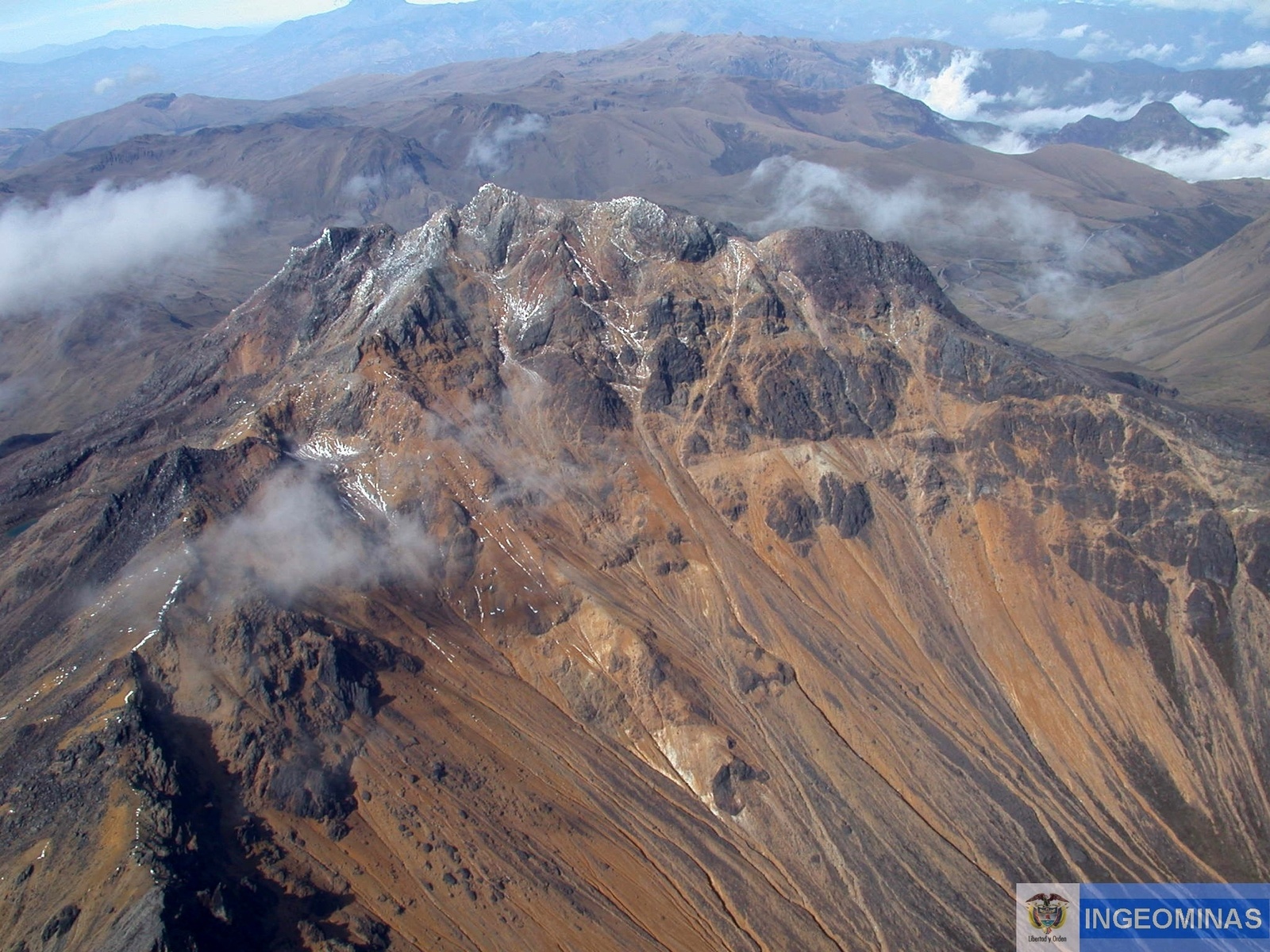
● The earthquakes were located mainly 2 km apart, in an area equidistant from the summits of Cerro Negro and Chiles, aligned from south to north, with depths ranging from 2 to 4 km from the summit of Chiles (4,700 m above sea level) and a maximum magnitude of 2.1. The other earthquakes were scattered throughout the region of the two volcanoes, at distances ranging from 0 to 18 km, with depths ranging from 2 to 14 km from the summit of Chiles (4,700 m above sea level) and a maximum magnitude of 2.5. No felt earthquakes were reported.
● Satellite sensors and ground stations measuring crustal deformation continue to show changes related to inflation processes in the volcanic zone. Based on the assessment and correlation of monitored parameters, the SGC recommends closely monitoring developments through weekly bulletins and other information published through our official channels, as well as instructions from local and departmental authorities and the National Disaster Risk Management Unit (UNGRD).
Volcanic activity remains on yellow alert: active volcano with changes in the baseline behavior of monitored parameters and other manifestations.
Source : SGC
Photo : Ingeominas .
Hawaii , Kilauea :
HAWAIIAN VOLCANO OBSERVATORY DAILY UPDATE , U.S. Geological Survey
Tuesday, June 24, 2025, 9:46 AM HST (Tuesday, June 24, 2025, 19:46 UTC)
19°25’16 » N 155°17’13 » W,
Summit Elevation 4091 ft (1247 m)
Current Volcano Alert Level: WATCH
Current Aviation Color Code: ORANGE
Activity Summary:
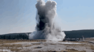
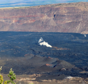
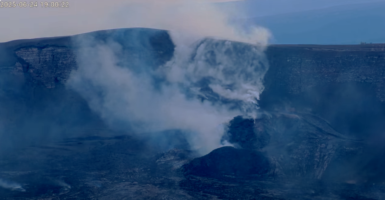
The ongoing Halema’uma’u eruption is paused. The preliminary forecast window for the start of episode 27 lava fountaining is between June 28 and July 4. This window is subject to change due to variations in summit inflation rate and other factors and will be refined as more data become available. Summit inflation continues, along with persistent and slightly elevated seismic tremor. Vigorous degassing continues from both vents. Magma remains close to the surface in both the north and south conduits and strong glow is visible from both vents at night.
Summit Observations:
Overnight, incandescence at both the north and south vents in Halemaʻumaʻu crater was visible in Kīlauea summit webcams. Lava flows from episode 26 on the floor of Halemaʻumaʻu within the southern part of Kaluapele (Kīlauea caldera) continue to exhibit minor incandescence as they cool and solidify.
The tiltmeter near Uēkahuna (UWD) has recorded nearly 10 microradians of inflationary tilt since the end of episode 26. UWD recorded more than 18 microradians of deflationary tilt during episode 26. Seismic tremor continues at slightly elevated levels beneath Halemaʻumaʻu crater.
Vigorous degassing also continues from both the north and south vents. The average Sulfur dioxide (SO2) emission rate during inter-episode pauses, such as the current pause, is typically around 1,200 t/d.
Source et photo : HVO