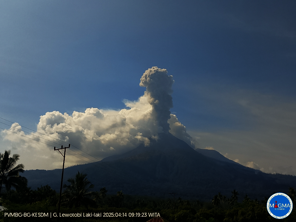
April 14 , 2025.
Indonesia , Lewotobi Laki-laki :
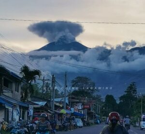
An eruption of Mount Lewotobi Laki-laki occurred on Monday, April 14, 2025, at 09:15 WITA with an observed ash column height of ± 1500 m above the peak (± 3084 m above sea level). The ash column was observed to be gray in color with a thick intensity, oriented toward the west and northwest. At the time of writing, the eruption was still ongoing.
VOLCANO OBSERVATORY NOTICE FOR AVIATION – VONA
Issued : April 14 , 2025
Volcano : Lewotobi Laki-laki (264180)
Current Aviation Colour Code : ORANGE
Previous Aviation Colour Code : orange
Source : Lewotobi Laki-laki Volcano Observatory
Notice Number : 2025LWK193
Volcano Location : S 08 deg 32 min 20 sec E 122 deg 46 min 06 sec
Area : East Nusa Tenggara, Indonesia
Summit Elevation : 5069 FT (1584 M)
Volcanic Activity Summary :
Eruption with volcanic ash cloud at 01h15 UTC (09h15 local).
Volcanic Cloud Height :
Best estimate of ash-cloud top is around 9869 FT (3084 M) above sea level or 4800 FT (1500 M) above summit. May be higher than what can be observed clearly. Source of height data: ground observer.
Other Volcanic Cloud Information :
Ash cloud moving from west to northwest. Volcanic ash is observed to be gray. The intensity of volcanic ash is observed to be thick.
Remarks :
Eruption and ash emission is continuing. Eruption recorded on seismogram with maximum amplitude 14.8 mm. Tremor recorded on seismogram with maximum amplitude 7.4 mm.
Source et photo : Magma Indonésie.
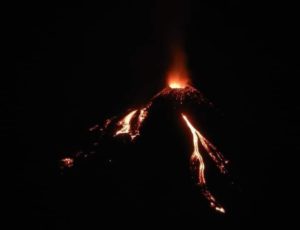
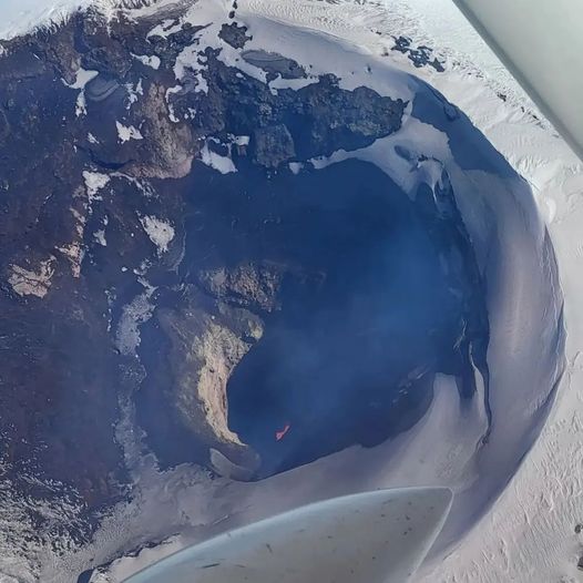
Chile , Villarica :
Seismology
The seismological activity for the period was characterized by the recording of:
9 VT-type seismic events, associated with rock fracturing (Volcano-Tectonic). The most energetic earthquake had a local magnitude (LM) value of 2.0, located 5.6 km south-southeast of the volcanic structure, at a depth of 4.6 km.
3,268 LP-type seismic events, associated with fluid dynamics within the volcanic system (Long Period). The size of the largest earthquake, evaluated using the reduced displacement (RD) parameter, was 26 cm².
102 TR-type seismic events, associated with sustained fluid dynamics within the volcanic system (TRemor). The size of the largest earthquake, evaluated using the reduced displacement (RD) parameter, was 4.6 cm². One VLP-type seismic event, associated with the dynamics of large fluid volumes within the volcanic system (Very Long Period). The earthquake size, estimated using the reduced displacement (DR) parameter, was 3.9 cm².
Fluid Geochemistry
Sulfur dioxide (SO2) emission data obtained using differential optical absorption spectroscopy (DOAS) equipment, corresponding to the Los Nevados and Tralco stations, installed 10 km east-northeast and 6 km east-southeast of the active crater, respectively, showed an average value of 312 ± 54 t/d for the month of March. These values are considered normal for this volcanic system. The maximum daily average for the month was 726 t/d on March 19. No anomalies in sulfur dioxide (SO2) emissions into the atmosphere have been reported in the area near the volcano, according to data published by the Tropospheric Monitoring Instrument (TROPOMI) and the Ozone Monitoring Instrument (OMI) Sulfur Dioxide Group.
Geodesy
According to data provided by the GNSS network, which measures the volcano’s deformation, a period of stability can be observed in the system, as evidenced by its low displacement rates, both horizontally and vertically. Vertical variations did not exceed 0.5 cm/month and are consistent with the annual cyclical process historically observed in the network. Using radar interferometry (InSAR) data, no obvious deformation was observed on the volcano.
Thermal anomalies from satellites
During this period, a thermal alert was recorded in the area associated with the volcano, with a maximum volcanic radiative power (VRP) of 19.4 MW, according to data processed by the MODIS sensor of the Mid-Infrared Volcanic Activity Observation Platform (MIROVA). Furthermore, according to analytical processing of Sentinel 2-L2A and Landsat 8-9 satellite images, in combination with false-color bands, thermal radiation from the crater is intermittently identified, with a maximum area of 1,600 m² on March 18, according to the Normalized Hotspot Indices algorithm (Marchese et al., 2019).
Activity has remained at levels considered low, suggesting the volcano’s stability. The technical volcanic alert remains in effect for:
GREEN TECHNICAL ALERT: Active volcano with stable behavior – No immediate risk
Observation:
Monitoring of the volcano’s surface and instrumental activity indicates a decrease in the frequency of explosions with the emission of high-temperature volcanic material outside the crater. As this is an open-conduit volcanic system, sudden explosions without precursors cannot be ruled out. Consistent with previous observations, the impact of these explosions is mainly concentrated at distances less than 500 m, measured from the crater center. However, in the current scenario, the low surface activity combined with the decline in monitoring parameters suggests a low probability of this type of activity occurring.
Source : Sernageomin
Photo : Richard L. ( 2022)
Colombia , Galeras :
San Juan de Pasto, April 8, 2025, 4:20 p.m.
Monitoring the activity of the Galeras Volcano, the Colombian Geological Survey (SGC), an entity affiliated with the Ministry of Mines and Energy, reports that:
Between April 1 and 7, 2025, volcanic activity showed similar levels to those of previous weeks in terms of seismicity. The main variations in the monitored parameters were:
• A slight increase in seismic occurrence was recorded, while the energy levels released decreased. Both in terms of occurrence and energy release, the predominance of seismicity associated with rock fracture processes within the volcanic system remained.
• The most recurrent seismic source was concentrated near the main crater, at distances of less than 1 km and at depths of up to 2.5 km from the Galeras summit (4,200 m above sea level). Other events were located scattered throughout the volcanic area, at distances of up to 10.6 km, at depths between 3 and 10 km, and with a maximum magnitude of 2.
• Gas emissions were observed, mainly from the fumarole fields of El Paisita, to the north, and Las Chavas, to the west of the active cone, with low white columns and variable dispersion depending on the wind direction.
• Other volcanic monitoring parameters showed stability.
Based on the above, the SGC recommends closely monitoring developments through weekly bulletins and other information published through our official channels, as well as instructions from local and departmental authorities and the National Disaster Risk Management Unit (UNGRD).
Volcanic activity remains on alert. Yellow: Active volcano with changes in the baseline level of monitored parameters and other manifestations.
Source et photo : SGC
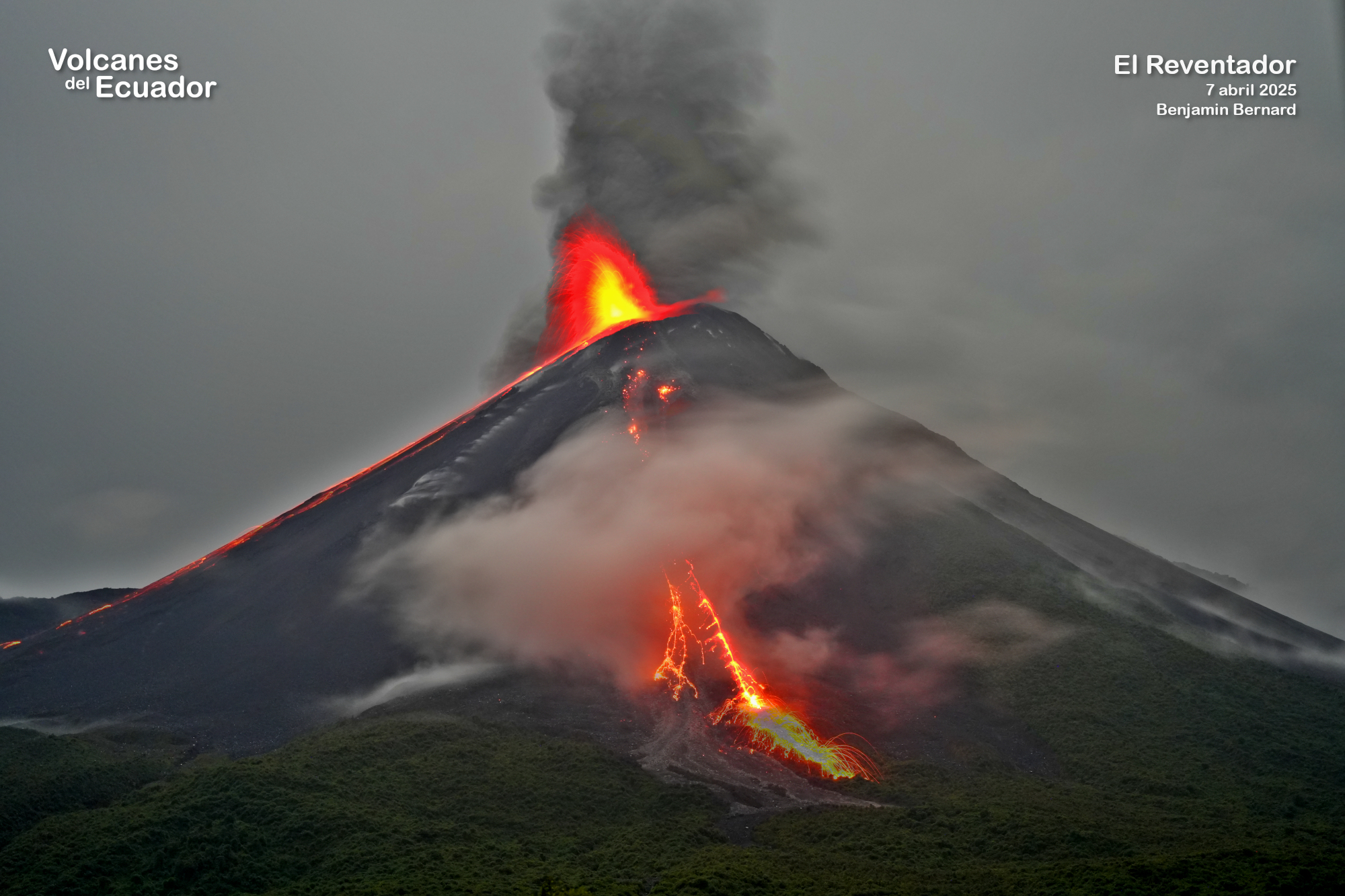
Ecuador , El Reventador .
DAILY STATUS REPORT OF REVENTADOR VOLCANO, Sunday, April 13, 2025.
Information Geophysical Institute – EPN.
Surface Activity Level: High, Surface Trend: Ascending
Internal Activity Level: Moderate, Internal Trend: No change
From April 12, 2025, 11:00 a.m. to April 13, 2025, 11:00 a.m.:
Seismicity:
Below is the count of seismic events recorded at the reference station.
Explosion (EXP) 87
Long Period (LP) 7
Emission Tremor (TREMI) 14
Harmonic Tremor (TRARM) 2
Rainfall/Lahars:
Precipitation was recorded in the volcano area without generating mudflows or debris flows. **Heavy rainfall could remobilize accumulated material, generating mudflows and debris flows that would cascade down the volcano’s flanks and flow into adjacent rivers.**
Emission/Ash Column:
Since yesterday afternoon, the surveillance camera network has recorded several gas and ash emissions, reaching heights between 300 and 500 meters above the crater level in west and southwest directions. Associated with this activity, the Washington-based VAAC agency has released three reports of ash emissions reaching heights of 1,000 meters above the crater level in southwest and west directions.
Other monitoring parameters:
Over the past 24 hours, the FIRMS satellite system recorded four thermal anomalies, the MIROVA-MODIS system detected one thermal anomaly, and the MIROVA-VIIRS system recorded two thermal anomalies.
Observation:
Early in the morning, several pyroclastic flows were observed descending the southwest flank of the volcano, up to 1,000 meters below the crater level. Furthermore, yesterday evening and early this morning, several descents of incandescent material were recorded on the flanks of the volcano, up to 1,000 meters below the crater level. At the time of writing, the volcano remains cloudy.
Alert Level – SGR: Orange
Source : IGEPN
Photo : 7 avril 2025 , Benjamin Bernard / Volcanes del Ecuador / FB.
Guatemala , Santiaguito :
Weather Conditions: Clear.
Wind: West, Northwest.
Precipitation: 1.2 mm.
Activity:
During the night and early morning, an incandescent glow was observed in the crater. This morning, Dome Caliente is emitting sustained white and blue fumes at an altitude of 3,000 meters. Santiaguito activity continues with weak, moderate, and strong explosions, accompanied by ash plumes at an altitude of 3,700 meters, extending southeast, east, and northeast for approximately 20 kilometers.
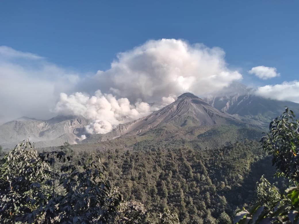
Ashfall is being recorded in the communities of Las Marías, Calaguache, and Belén, with the risk of spreading to Santa María de Jesús and other areas. The activity described is accompanied by constant avalanches, some of which are accompanied by short-range pyroclastic flows. The southwest flank is the most active, with avalanches fueling the growth of promontories and possibly a new lava flow. This causes incandescence and ash upwelling. Due to the activity described, larger pyroclastic flows, similar to those of 2022, may be generated. Therefore, it is recommended not to approach the dome areas or remain near or in the ravines near the volcanic complex. Please note that rain is occurring in the volcanic area and lahars may be generated.
Source : Insivumeh.
Photo : Noticias la Red GT San José del Golfo