October 16 , 2024 .
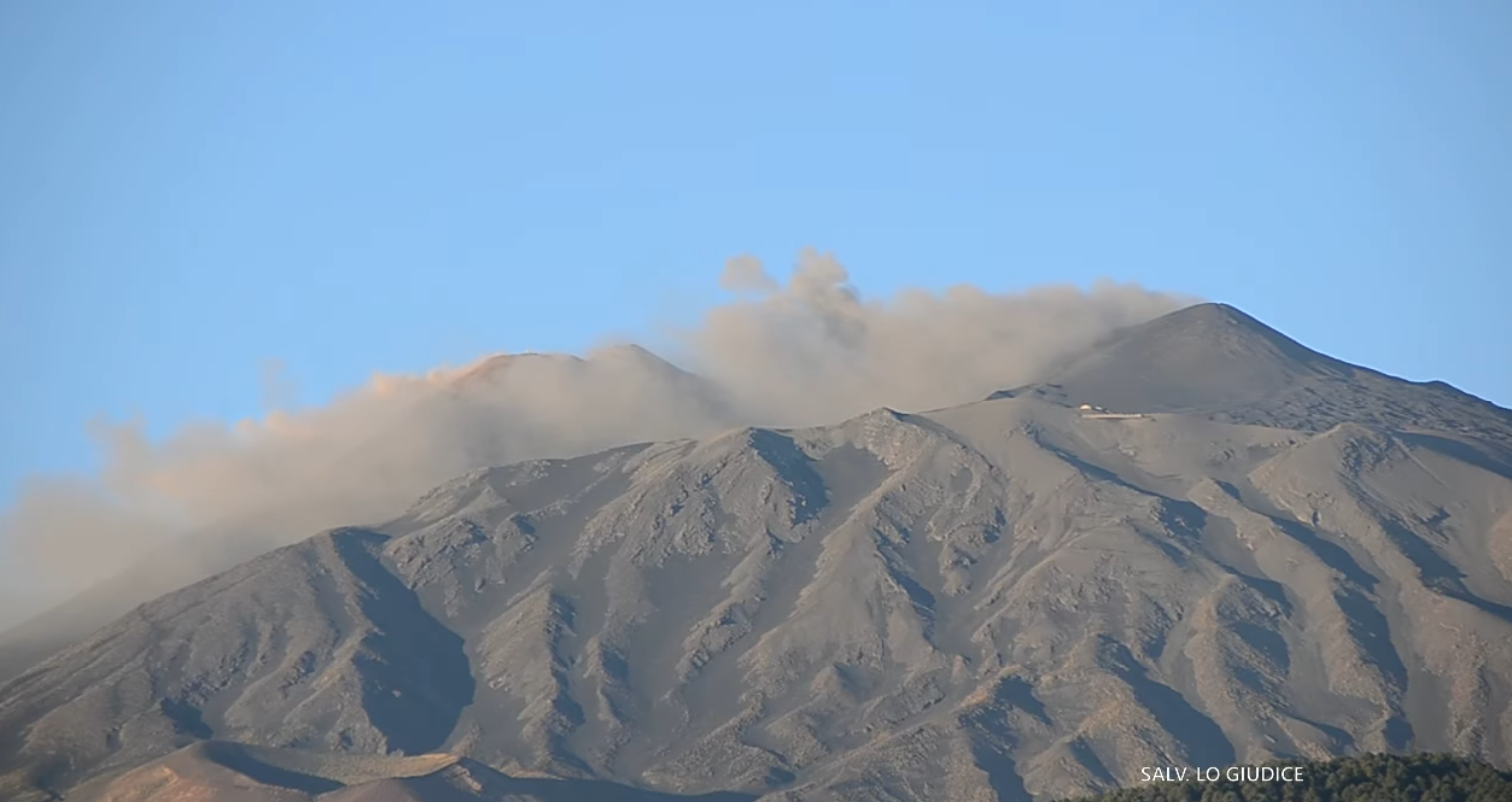
Italy / Sicily , Etna :
WEEKLY BULLETIN, from October 07, 2024 to October 13, 2024. (issue date October 15, 2024)
SUMMARY STATUS OF ACTIVITY
In light of the monitoring data, it emerges:
1) VOLCANOLOGICAL OBSERVATIONS: Degassing activity at the summit craters, low intra-crater explosive activity at the Northeast Crater and light and sporadic emission of volcanic ash at the Southeast Crater.
2) SEISMOLOGY: Absence of seismic fracturing activity with Ml>=2.0. Average amplitude of volcanic tremor at the average level.
3) INFRASOUND: Moderate infrasound activity with sources located mainly in correspondence with the Southeast Crater crater.
4) GROUND DEFORMATIONS: Over the past week, ground deformation monitoring networks have not recorded significant changes
5) GEOCHEMISTRY: SO2 flux at an average and increasing level
The CO2 flux from the soil remains low.
The partial pressure of dissolved CO2 in groundwater shows values within the seasonal variability.
Helium isotope ratio: No update available
6) SATELLITE OBSERVATIONS: The thermal activity observed by satellite in the summit area was generally low with some isolated thermal anomalies of moderate level.
VOLCANOLOGICAL OBSERVATIONS
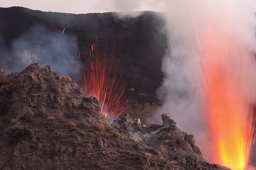
During the week, the monitoring of the volcanic activity of Etna was carried out through the analysis of images from the surveillance camera network of the National Institute of Geophysics and Volcanology, Osservatorio Etneo (INGV-OE) and through field observations carried out by the INGV-OE staff present in the summit area. During the period under review, the activity was a continuous degassing of variable intensity affecting all the summit craters. In addition, intra-crater explosive activity was observed at the North-East crater and light and sporadic emissions of volcanic ash at the South-East crater.
In particular, the activity of the North-East crater remains unchanged compared to what was reported in the bulletin of 8 October and was characterized by intra-crater explosive activity visible on 12 October. During the week, they were also observed, both by the INGV-OE staff present in the summit area and by the analysis of the images of the INGV-OE surveillance cameras, light and sporadic emissions of volcanic ash produced by a vent located on the northern rim of the South-East crater. Finally, a degassing activity of varying intensity was observed on all the summit craters during the week.
Source : INGV
Photo : Capture d’écran 15/10/2024 , Salvatore Lo Giudice
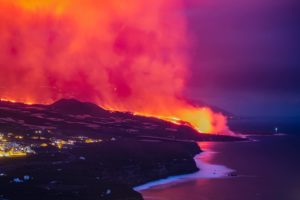
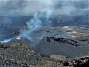
Italy , Stromboli :
WEEKLY BULLETIN, from October 07, 2024 to October 13, 2024. (issue date October 15, 2024)
SUMMARY STATUS OF ACTIVITY
In light of the monitoring data, it emerges:
1) VOLCANOLOGICAL OBSERVATIONS: During this period, intense eruptive activity was observed with splashes coming from the North crater area with two lava flows on October 8 and 9. The total hourly frequency fluctuated between average values (7-15 events/h). The intensity of the explosions was low in the North crater area and medium to high in the South Center area.
2) SEISMOLOGY: The monitored seismological parameters do not show significant variations.
3) GROUND DEFORMATIONS: The island’s ground deformation monitoring networks did not show any significant changes to report for the period under review.
4) GEOCHEMISTRY: SO2 flux at medium level
The CO2 flux from the ground in the STR02 summit area is at medium values.
The CO2/SO2 ratio in the plume during the last week oscillates between medium and high values.
The helium isotope ratio in the thermal aquifer is at medium values (R/Ra = 4.34) given on 29/09/2024
CO2 flux at Mofeta, in the San Bartolo area: it is at medium values.
CO2 flux at Scari: medium-high values around 150 g/m2/day.
5) SATELLITE OBSERVATIONS: The thermal activity observed by satellite in the summit area was generally low. Moderate level values were observed in correspondence with the spatter activity in the crater area on 8 and 9 October 2024.
VOLCANOLOGICAL OBSERVATIONS
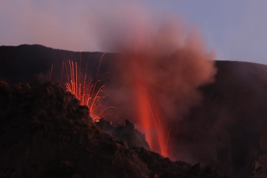
During the observed period, the eruptive activity of Stromboli was characterized through the analysis of images recorded by the INGV-OE surveillance cameras located at altitude 190 m (SCT-SCV) and at Punta dei Corvi (SPCT). The explosive activity was mainly produced by 2 (two) eruptive vents located in the North area of the crater and by 2 (two) vents located in the Central South area.
On 8 and 9 October, two lava flows were produced in the North crater area.
Observations of explosive activity captured by surveillance cameras
In the North Crater (N) area, two active vents characterized by low-intensity explosive activity (less than 80 m high) were observed. In addition, variable spatter activity was observed, intense and continuous for long periods on 8-9 and 13 October. The eruption products were mainly coarse materials (bombs and lapilli). The average explosion frequency ranged from 7 to 14 events/h.
In the Centre-South (CS) area, explosive activity was produced by at least two vents, the explosions were of variable intensity ranging from medium (less than 150 m high) to high (more than 250 m high) emitting fine materials mixed with coarse materials. The average explosion frequency ranged from 1 to 1 event/h.
Lava flows on 8 and 9 October.
On 8 October, after intense spattering activity in the North Crater area, at around 16:43 UTC, a lava flow started that flowed into the pre-existing canyon, accumulating in the central area of the Sciara without reaching the coastline. By 19:30 UTC, the lava flow was underfed and cooling.
On 9 October, after intense spattering activity in the North Crater area, at around 12:20 UTC, a lava flow started that flowed into the pre-existing canyon, accumulating in the central area of the Sciara without reaching the coastline. By 14:32 UTC, the lava flow was underfed and cooling
Source : INGV
Photos : Stromboli stati d’animo / Sebastiano Cannavo.
Kamchatka , Karymsky :
VOLCANO OBSERVATORY NOTICE FOR AVIATION (VONA)
Issued: October 15 , 2024
Volcano: Karymsky (CAVW #300130)
Current aviation colour code: ORANGE
Previous aviation colour code: orange
Source: KVERT
Notice Number: 2024-85
Volcano Location: N 54 deg 2 min E 159 deg 26 min
Area: Kamchatka, Russia
Summit Elevation: 1486 m (4874.08 ft)
Volcanic Activity Summary:
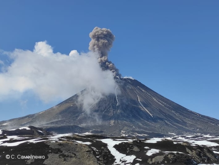
The explosive activity of the Karymsky volcano continues. Satellite data by KVERT showed explosions sent ash 2.5 km from the volcano, and an ash plum is drifting for 50 km to the eastnortheast of the volcano.
A moderate activity of the volcano continues. Ash explosions up to 10 km (32,800 ft) a.s.l. could occur at any time. Ongoing activity could affect international and low-flying aircraft.
Volcanic cloud height:
2500-3000 m (8200-9840 ft) AMSL Time and method of ash plume/cloud height determination: 20241015/2250Z – Himawari-9 14m15
Other volcanic cloud information:
Distance of ash plume/cloud of the volcano: 50 km (31 mi)
Direction of drift of ash plume/cloud of the volcano: ENE / azimuth 62 deg
Time and method of ash plume/cloud determination: 20241015/2250Z – Himawari-9 14m15
Source : KVERT
Photo : S. Samoylenko ( 05/2022)
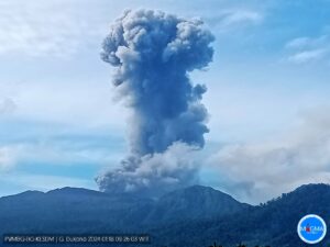
Indonesia , Ibu :
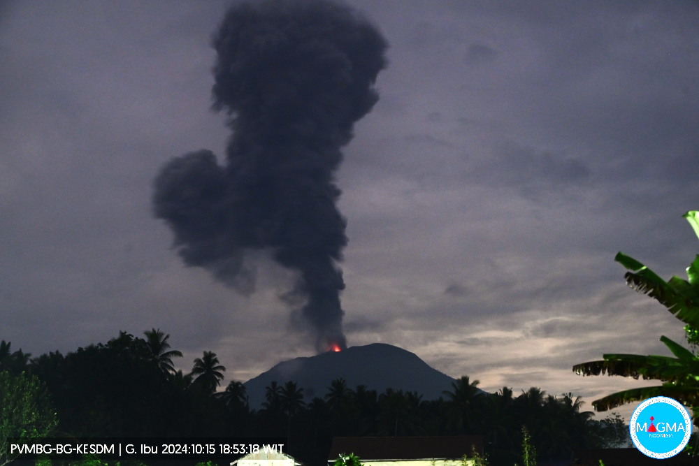
Ibu erupted on Tuesday, 15 October 2024 at 18:49 WIT with the height of the ash column observed at ±2,000 m above the summit (±3,325 m above sea level). The ash column was observed to be grey with a thick intensity, oriented towards the West. This eruption was recorded on a seismograph with a maximum amplitude of 28 mm and a duration of 220 seconds.
VOLCANO OBSERVATORY NOTICE FOR AVIATION – VONA
Issued : October 15 , 2024
Volcano : Ibu (268030)
Current Aviation Colour Code : ORANGE
Previous Aviation Colour Code : orange
Source : Ibu Volcano Observatory
Notice Number : 2024IBU944
Volcano Location : N 01 deg 29 min 17 sec E 127 deg 37 min 48 sec
Area : North Maluku, Indonesia
Summit Elevation : 4240 FT (1325 M)
Volcanic Activity Summary :
Eruption with volcanic ash cloud at 09h49 UTC (18h49 local).
Volcanic Cloud Height :
Best estimate of ash-cloud top is around 10640 FT (3325 M) above sea level or 6400 FT (2000 M) above summit. May be higher than what can be observed clearly. Source of height data: ground observer.
Other Volcanic Cloud Information :
Ash cloud moving to west. Volcanic ash is observed to be gray. The intensity of volcanic ash is observed to be thick.
Remarks :
Eruption recorded on seismogram with maximum amplitude 28 mm and maximum duration 220 second.
Source and photo : Magma Indonésie .
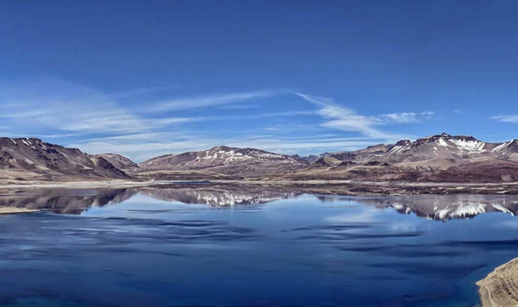
Chile , Laguna del Maule :
Seismology
The seismological activity of the period was characterized by the recording of:
2388 VT type seismic events, associated with rock fracturing (Volcano-Tectonic). The most energetic earthquake had a Local Magnitude (ML) value equal to 2.0, located 3.5 km to the South-Southeast of the center of the lagoon, at a depth of 9.3 km.
1 LP type seismic event, associated with fluid dynamics inside the volcanic system (Long Period). The size of the earthquake evaluated from the Reduced Displacement (DR) parameter was equal to 0.5 cm2.
1 TR type seismic event, associated with the dynamics maintained over time of fluids inside the volcanic system (TRemor). The size of the earthquake evaluated from the Reduced Displacement (DR) parameter was equal to 1.7 cm2.
Fluid Geochemistry
No anomalies were reported in sulfur dioxide (SO2) emissions into the atmosphere in the area near the volcanic complex, according to data published by the Tropopheric Monitoring Instrument (TROPOMI) and the Ozone Monitoring Instrument (OMI) Sulphur Dioxide Group.
Thermal anomalies by satellites
During the period, no thermal alerts were recorded in the area associated with the volcanic complex, according to the analytical processing of Sentinel 2-L2A satellite images, in combination with false-color bands.
Geodesy
Data provided by the geodetic monitoring network, composed of 5 GNSS stations, indicate that the swelling process of the volcanic complex is continuing. For this period, a maximum rise rate, greater than 2.0 cm/month, slightly higher than the previous period.
Activity remained at levels considered low, suggesting stability of the volcanic system. The volcanic technical alert is maintained at:
GREEN TECHNICAL ALERT: Active volcano with stable behavior – There is no immediate risk
Observation:
The area concerned is considered to be that located within a radius of 2 km around the passive CO2 degassing zone.
Source : Sernageomin
Photo : Senapred / Rayen Gho. (05/2024)