September 27 , 2024.
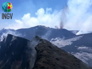
Chile , Laguna del Maule :
Special Report on Volcanic Activity (REAV), Maule Regions, Laguna del Maule Volcanic Complex, September 26, 2024, 23:50 local time (Continental Chile)
The National Geology and Mining Service of Chile (Sernageomin) announces the following PRELIMINARY information, obtained through the monitoring equipment of the National Volcanic Monitoring Network (RNVV), processed and analyzed at the Southern Andean Volcano Observatory (Ovdas):
On Thursday, September 26 at 21:26 (00:26 UTC), the monitoring stations installed near the Laguna del Maule volcanic complex recorded a volcano-tectonic seismic swarm (associated with rock fracturing). At the time of issuing this report, there are more than 120 classified events.
The characteristics of the most significant earthquake after its analysis are as follows:
TIME OF ORIGIN: 22:39 local time (01:39 UTC on September 27)
LATITUDE: 36.060° S
LONGITUDE: 70.478° West
DEPTH: 5.5 km
LOCAL MAGNITUDE: 1.1 (ML)
Observation:
At the time of this report, a volcano-tectonic seismicity of lower energy and occurrence is observed.
The volcanic technical alert is maintained at GREEN level.
Source et photo : Sernageomin
Kamchatka , Sheveluch :
VOLCANO OBSERVATORY NOTICE FOR AVIATION (VONA)
Issued: September 26 , 2024
Volcano: Sheveluch (CAVW #300270)
Current aviation colour code: ORANGE
Previous aviation colour code: orange
Source: KVERT
Notice Number: 2024-77
Volcano Location: N 56 deg 38 min E 161 deg 18 min
Area: Kamchatka, Russia
Summit Elevation: 3283 m (10768.24 ft), the dome elevation ~2500 m (8200 ft)
Volcanic Activity Summary:
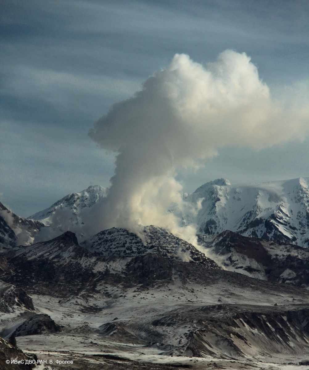
Video and satellite data by KVERT shows a strong wind lifts ash from the southern slopes of Sheveluch volcano, and a plume of resuspended ash is extending about 256 km to the east-southeast of the volcano.
An extrusive-effusive eruption of the Sheveluch volcano continues. The danger of ash explosions up to 10 km (32,800 ft) a.s.l. remains. Ongoing activity could affect international and low-flying aircraft.
Volcanic cloud height:
2500-3000 m (8200-9840 ft) AMSL Time and method of ash plume/cloud height determination: 20240926/2155Z – Video data
Other volcanic cloud information:
Distance of ash plume/cloud of the volcano: 256 km (159 mi)
Direction of drift of ash plume/cloud of the volcano: ESE / azimuth 121 deg
Time and method of ash plume/cloud determination: 20240926/2120Z – Himawari-9 14m15
Source : Kvert.
Photo : V. Frolov. IVS FEB RAS ( 04/2024)
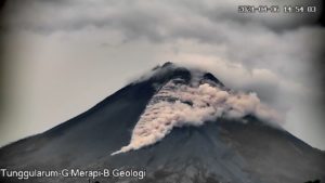
Indonesia , Ibu :
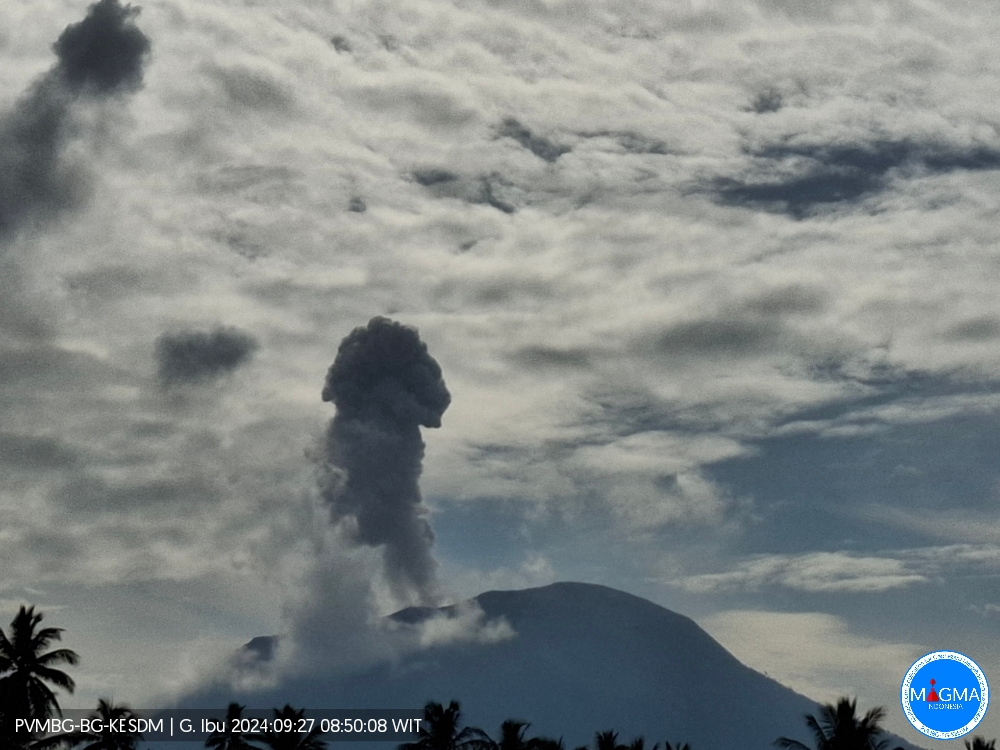
An eruption of Ibu occurred on Friday, 27 September 2024 at 08:48 WIT with the height of the ash column observed at ± 600 m above the summit (± 1925 m above sea level). The ash column was observed to be grey with a thick intensity, oriented towards the northwest. This eruption was recorded on a seismograph with a maximum amplitude of 28 mm and a duration of 59 seconds.
VOLCANO OBSERVATORY NOTICE FOR AVIATION (VONA)
Issued : September 27 , 2024
Volcano : Ibu (268030)
Current Aviation Colour Code : ORANGE
Previous Aviation Colour Code : orange
Source : Ibu Volcano Observatory
Notice Number : 2024IBU899
Volcano Location : N 01 deg 29 min 17 sec E 127 deg 37 min 48 sec
Area : North Maluku, Indonesia
Summit Elevation : 4240 FT (1325 M)
Volcanic Activity Summary :
Eruption with volcanic ash cloud at 23h48 UTC (08h48 local).
Volcanic Cloud Height :
Best estimate of ash-cloud top is around 6160 FT (1925 M) above sea level or 1920 FT (600 M) above summit. May be higher than what can be observed clearly. Source of height data: ground observer.
Other Volcanic Cloud Information :
Ash cloud moving to northwest. Volcanic ash is observed to be gray. The intensity of volcanic ash is observed to be thick.
Remarks :
Eruption recorded on seismogram with maximum amplitude 28 mm and maximum duration 59 second.
Source et photo : Magma Indonésie
Colombia , Galeras :
San Juan de Pasto, September 24, 2024, 4:15 p.m.
From the monitoring of the activity of the Galeras volcano, the Colombian Geological Survey (SGC), an entity attached to the Ministry of Mines and Energy, reports that:
During the week of September 17 to 23, 2024, the activity of the volcano maintained a stable behavior. Compared to the previous week, the main variations in the monitored parameters were:
● An increase in the frequency and energy of earthquakes was recorded.
● The predominance of seismicity associated with rock fracturing within the volcanic system persisted.
● Fracture earthquakes were located dispersedly in the volcanic area, at distances between 1 and 16 km and at depths between 1 and 14 km from the summit of Galeras. The seismic source is distinguished to the northeast of the volcano and in particular the earthquake of September 22 at 05:16, located about 15 km northeast of Galeras, 10 km deep and with a magnitude of 2.6, which was reported to have been felt by some residents of Pasto.

● Gas emissions were observed from the main crater and the fumarole fields of Las Chavas, to the west, and El Paisita, to the north of the active cone, with small white columns of variable height and dispersion due to the action of the winds.
● The other volcanic monitoring parameters showed stability.
Based on the above, the SGC recommends closely monitoring the evolution through the weekly bulletins and other information published through our official channels, as well as the instructions of the local and departmental authorities and the National Disaster Risk Management Unit (UNGRD).
Volcanic activity remains in yellow alert status: active volcano with changes in the behavior of the base level of the monitored parameters and other manifestations.
Source et photo : SGC
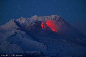
Guatemala , Fuego :
Weather conditions: Clear.
Wind: North-West
Rainfall: 18.4 mm.
Activity:
A white degassing fumarole is reported at an altitude of 4,200 metres above sea level that is dispersing towards the east and southeast. Between 5 and 8 explosions of weak to moderate characteristics are generated per hour that raise columns of gas and ash to heights of 4,100 to 4,300 metres above sea level (13,451.44 to 14,107.61 ft), which move towards the east and southeast at distances of up to 30 km. The explosions generate slight rumbling sounds.
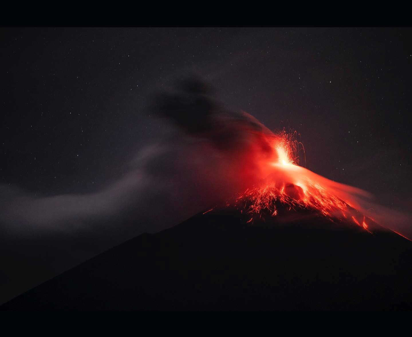
At night, incandescent pulses are observed rising between 100 and 200 meters above the crater level, covering the crater area with fragments of incandescent rocks. The Fuego Volcano Observatory (OVFGO) reports the collapse and descent of volcanic material from the crater rim. Due to the wind direction, ash falls are reported on Rochela, Ceilán, El Zapote, El Rodeo and others. In the afternoon and at night, rains could cause lahars to descend into different ravines of the volcano.
Source : Insivumeh
Photo : Diego Rizzo ( 12/2022)