August 26 , 2024 .
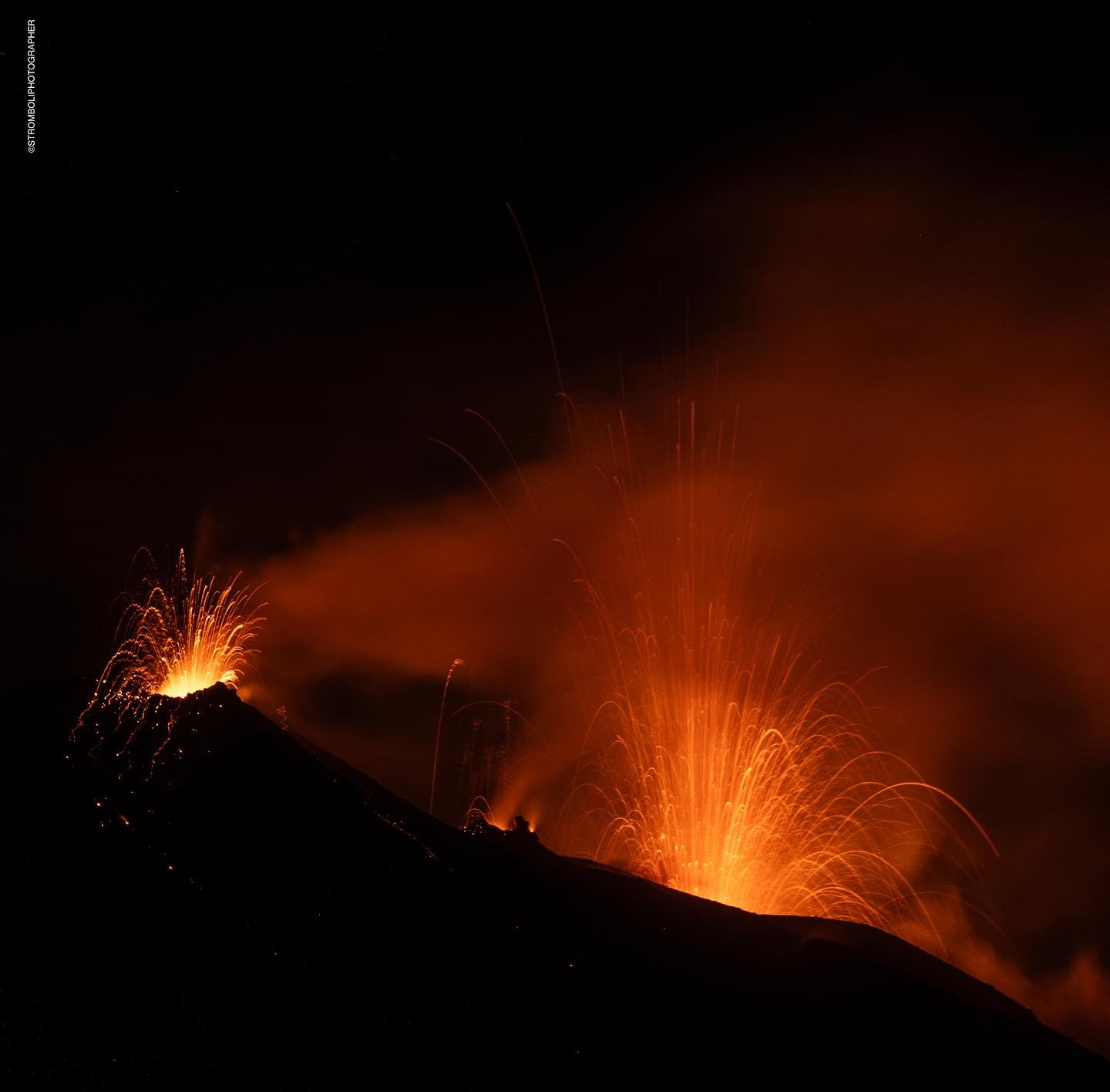
Italy , Stromboli :
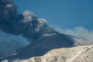
Statement on the activity of Stromboli, 25 August 2024 14:21 (12:21 UTC) .
The National Institute of Geophysics and Volcanology, Osservatorio Etneo, reports that at 09:40 UTC, a more energetic explosion than usual was detected from the images of the surveillance cameras, causing the fall of coarse pyroclastic material on the upper part of the Sciara del Fuoco.
The INGV seismic network of Stromboli recorded at 09:40 UTC an event with an amplitude higher than the average of the last weeks and a duration of about 2 minutes.
The average amplitude of the volcanic tremor was within the average range and no changes were observed after the 09:40 UTC event. The amplitude of the explosion earthquakes remains low.
The inclinometer network recorded a transient deformation of 0.1 microradians at the TDF station at 09:40 UTC. No significant changes were recorded on the deformation data from the high-frequency GNSS network.
Further updates will be provided shortly.
Source : INGV
Photo : Stromboli stati d’animo / Sebastiano Cannavo. (06/2024)
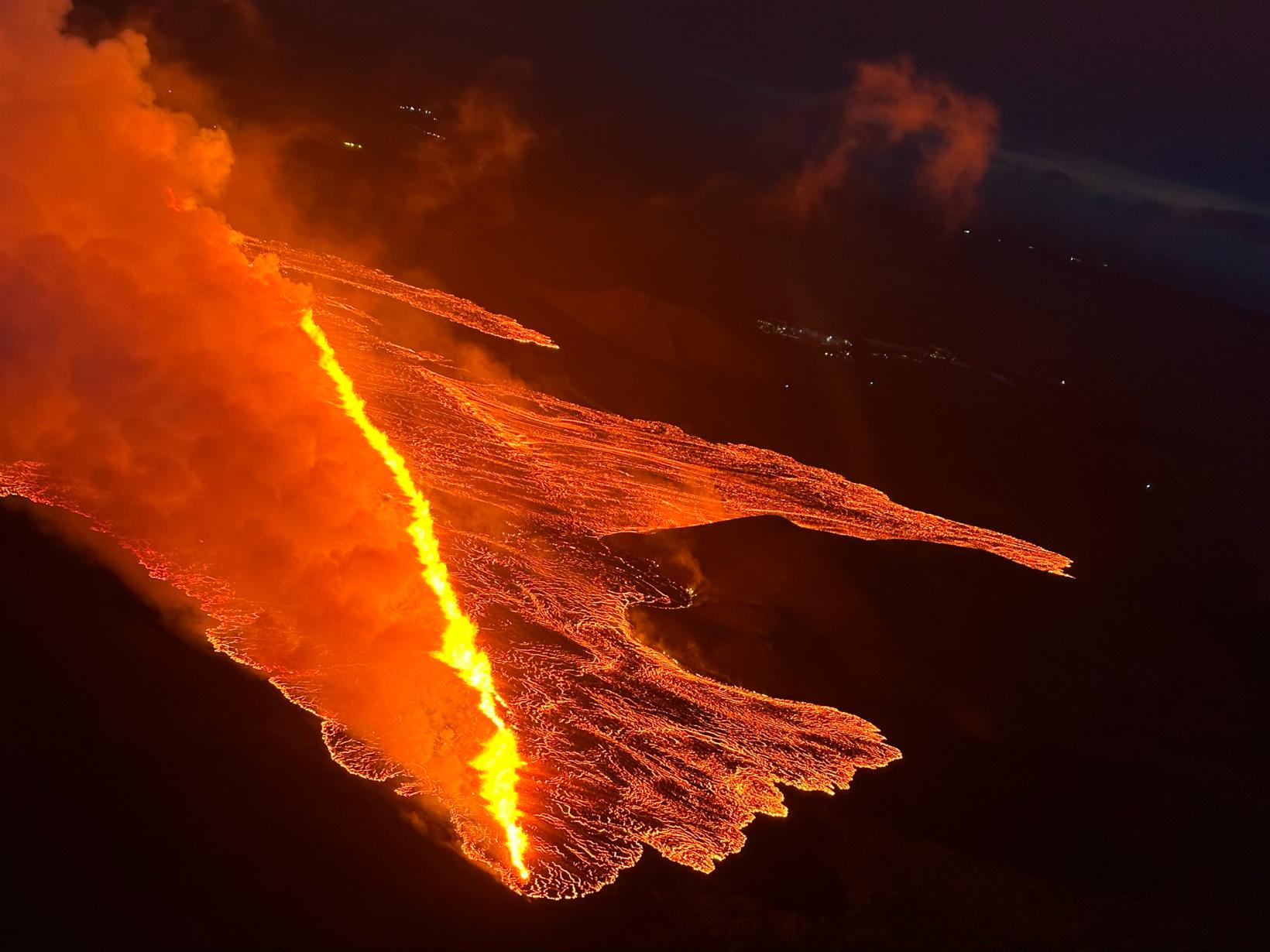
Iceland , Reykjanes Peninsula :
An earthquake of magnitude 2.2 was measured in the magma tunnel north of Stóra-Skógfell at 2 a.m. This is the largest earthquake in the area since Thursday.
This is what Bryndís Ýr Gísladóttir, a natural disaster expert at the Icelandic Meteorological Office, says in an interview with mbl.is.
On Thursday evening, an earthquake of magnitude 4.1 was measured and its source was located 3 km northeast of Stóra-Skógfell.
Byrndís says there is still constant activity in the eruption that started on Thursday night. She says little has changed since yesterday.
Seismic activity in the area has been low since the eruption began, with occasional earthquakes recorded north of Stóra-Scógfell and at Fagradalsfjall.
The lava flow towards Grindavíkurveg appears to have stopped
Source : Mbl.is
Photo : The Icelandic Coast Guard
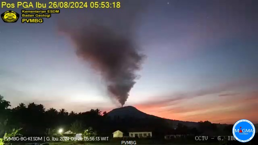
Indonesia , Ibu :
An eruption of Mount Ibu occurred on Monday, 26 August 2024 at 05:52 WIT with the height of the ash column observed at ± 600 m above the summit (± 1925 m above sea level). The ash column was observed to be grey with a thick intensity, oriented towards the West. This eruption was recorded on a seismograph with a maximum amplitude of 15 mm and a duration of 41 seconds.
VOLCANO OBSERVATORY NOTICE FOR AVIATION – VONA
Issued : August 26 , 2024
Volcano : Ibu (268030)
Current Aviation Colour Code : ORANGE
Previous Aviation Colour Code : orange
Source : Ibu Volcano Observatory
Notice Number : 2024IBU553
Volcano Location : N 01 deg 29 min 17 sec E 127 deg 37 min 48 sec
Area : North Maluku, Indonesia
Summit Elevation : 4240 FT (1325 M)
Volcanic Activity Summary :
Eruption with volcanic ash cloud at 20h52 UTC (05h52 local).
Volcanic Cloud Height :
Best estimate of ash-cloud top is around 6160 FT (1925 M) above sea level or 1920 FT (600 M) above summit. May be higher than what can be observed clearly. Source of height data: ground observer.
Other Volcanic Cloud Information :
Ash cloud moving to west. Volcanic ash is observed to be gray. The intensity of volcanic ash is observed to be thick.
Remarks :
Eruption recorded on seismogram with maximum amplitude 15 mm and maximum duration 41 second.
Source et photo : Magma Indonésie
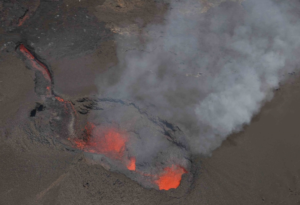
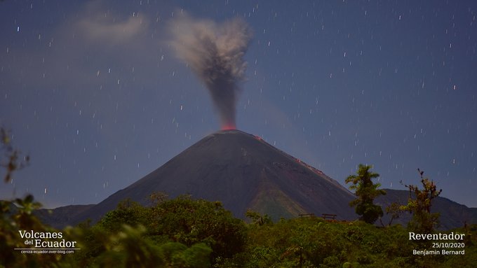
Ecuador , Reventador :
DAILY REPORT ON THE STATE OF THE REVENTADOR VOLCANO, Sunday, August 25, 2024.
Information Geophysical Institute – EPN.
Surface Activity Level: High, Surface Trend: No Change
Internal Activity Level: Moderate, Internal Trend: No Change
From August 24, 2024, 11:00 a.m. to August 25, 2024, 11:00 a.m.:
Seismicity:
Below is the count of seismic events recorded at the reference station
Explosion (EXP): 62
Rainfall / Lahars:
No rain has been recorded in the volcano area. **In case of heavy rain, it could remobilize the accumulated materials and generate mud and debris flows that would descend the sides of the volcano and flow into the rivers downstream.**
Emissions/ash column:
Due to transmission problems, it was not possible to observe emissions via the surveillance camera system. However, the Washington VAAC agency has not published reports for this volcano.
Other monitoring parameters:
In the last 24 hours, the FIRMS satellite system recorded 2 thermal anomalies.
Observation:
From yesterday afternoon until the closing of this report, the volcano remained mostly cloudy.
Alert level: Orange
Source : IGEPN.
Photo : Benjamin Bernard
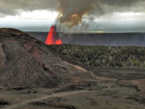
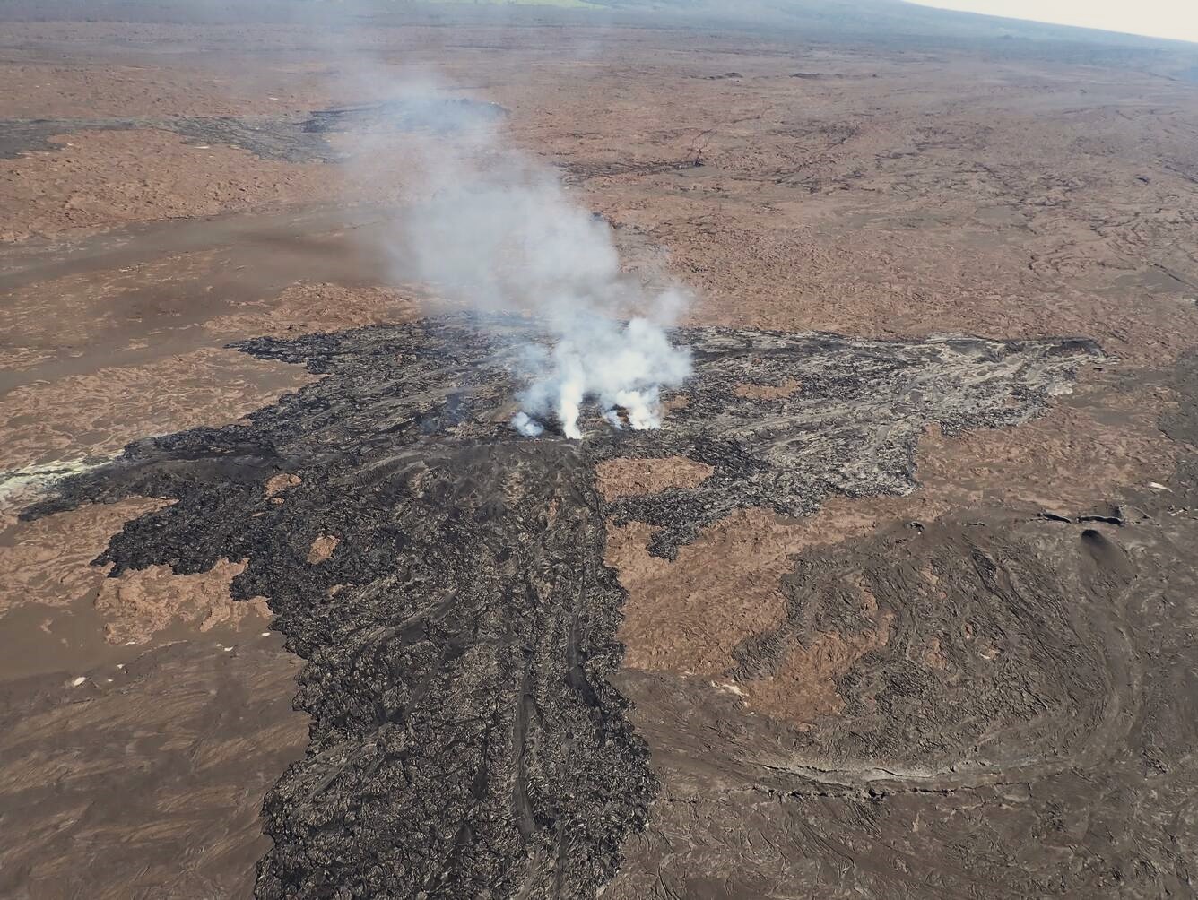
Hawaii , Kilauea :
Sunday, August 25, 2024, 9:07 AM HST (Sunday, August 25, 2024, 19:07 UTC)
19°25’16 » N 155°17’13 » W,
Summit Elevation 4091 ft (1247 m)
Current Volcano Alert Level: ADVISORY
Current Aviation Color Code: YELLOW
Activity Summary:
Kīlauea is not erupting. Increased earthquake activity and rates of ground deformation at Kīlauea’s upper East Rift Zone (UERZ) began early Tuesday morning (8/20). Activity has progressively decreased over the past several days. Changes in the character and location of unrest can occur quickly, as can the potential for eruption, but there are no signs of imminent eruption at this time. There are no significant changes in activity in the lower East Rift Zone and Southwest Rift Zone.
Summit Observations:
Approximately 5 earthquakes were detected beneath Kaluapele (Kīlauea’s summit caldera) over the past 24 hours at depths of 1–3 km (0.6–1.9 mi) below the ground surface with magnitudes of less than M2.0. Rates of deformation at the summit remained relatively low. An overall gradual inflationary trend continues to be seen on GPS instruments around the summit region. The most recent measurement of the summit’s SO2 emission rate was approximately 75 tonnes per day on August 20, 2024.
Rift Zone Observations:
Over the past 24 hours, there have been approximately 21 earthquakes beneath Kīlauea’s UERZ region, extending from Puhimau Crater southeast to Maunaulu. Most earthquakes have been smaller than M2.0. Events have remained at depths of 1–3 km (0.6–1.8 miles) beneath the surface. Currently, deformation remains stable and level over the past 24 hours.
Activity in the middle East Rift Zone (MERZ) remains low. Changes in the POC tiltmeter overnight appear to be due to ongoing heavy rainfall. GPS instruments continue to record inflation in the region.
Measurements from continuous gas monitoring stations downwind of Puʻuʻōʻō in the middle East Rift Zone—the site of 1983–2018 eruptive activity—remain below detection limits for SO2, indicating that SO2 emissions from this area are negligible.
At this time, there is no evidence of elevated seismicity or ground deformation beneath the lower East Rift Zone, and Southwest Rift Zone activity remains low. Current activity is restricted to the summit and upper East Rift Zone region.
Source : HVO
Photo : USGS / A.R. Nalesnik.( 06/2024)