July 25 , 2024.
Italy / Sicily , Etna :
WEEKLY BULLETIN, from July 15, 2024 to July 21, 2024. (issue date July 23, 2024)
SUMMARY STATEMENT OF ACTIVITY
In light of the monitoring data, it appears:
1) VOLCANOLOGICAL OBSERVATIONS: Degassing activity at the Bocca Nuova crater and at the South-East crater. Strombolian activity and lava fountain event on July 15 at the Voragine crater.
Explosive activity and ash emission at the Northeast crater.
2) SISMOLOGY: Absence of seismic fracturing activity with Ml>=2.0. Strong volcanic tremor during the lava fountain of July 15. In the following days, the amplitude of the tremor oscillated between the medium value and the low value.
3) INFRASOUND: Strong infrasound activity during the lava fountain of July 15. Low infrasound activity for the rest of the week.
4) GROUND DEFORMATIONS: During the last week of observation, the ground deformation monitoring networks recorded variations during the paroxysmal episode of the
July 15-16.
5) GEOCHEMISTRY: The flow of SO2 at a low to medium level
The soil CO2 flux is at average values.
CO2 dissolved in groundwater does not show significant variations.
There is no update on the helium isotope ratio, the latest data from July 9 is at high levels.
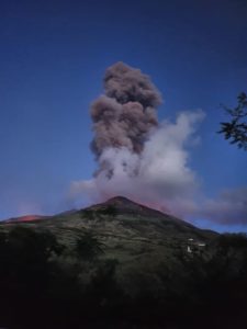
6) SATELLITE OBSERVATIONS: The thermal activity observed by satellite in the summit area was generally of a moderate level with high to very high values corresponding to the activity of the lava fountains of July 15 and July 23, 2024.
7) OTHER OBSERVATIONS: Drone flights carried out on July 17 made it possible to map and quantify the products erupted during the paroxysm of July 15.
VOLCANOLOGICAL OBSERVATIONS
Monitoring of the volcanic activity of Etna was carried out through the analysis of images from the INGV surveillance camera network, Osservatorio Etneo (INGV-OE) and various inspections carried out by INGV staff in the summit area.
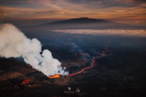
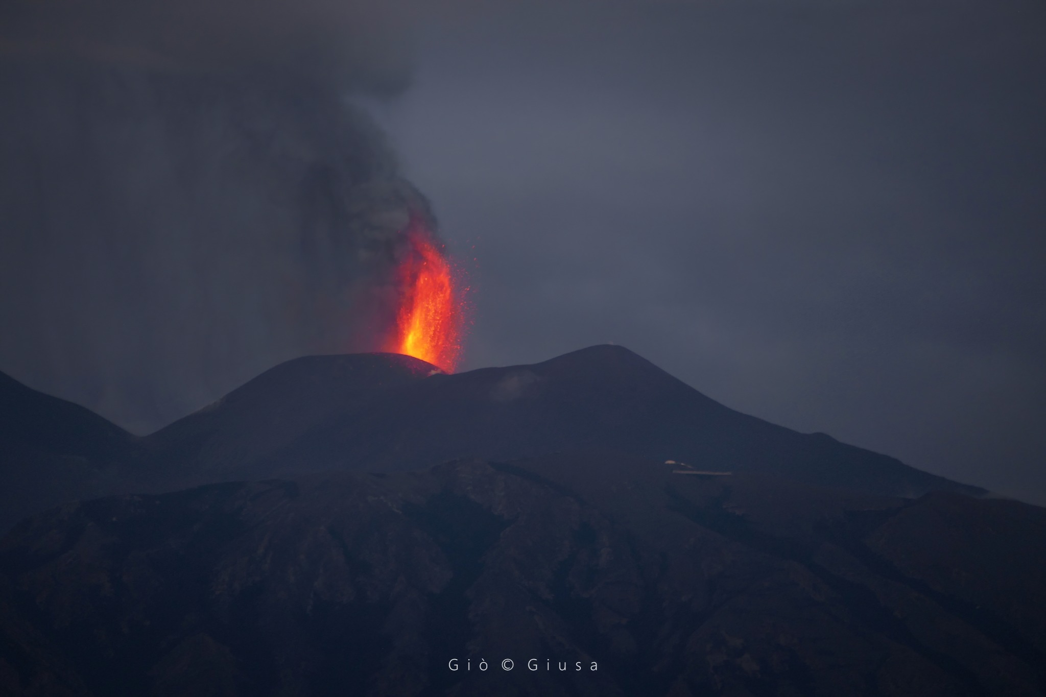
During the period under review, the activity of the summit craters of Etna was characterized by a lava fountain at the Voragine crater, which occurred on July 15. In particular, after days of discontinuous and modest Strombolian explosive activity, on July 15 the Voragine crater produced a third lava fountain event later (hereinafter UTC times) than those that occurred on July 5 and Approximately July 7. Strombolian activity gradually begins to intensify from around 4 p.m., further increasing the frequency and energy of the explosions from 6 p.m. Between 6:45 p.m. and 7 p.m., Strombolian activity evolves rapidly towards a lava fountain, producing an eruptive column which rises to approximately 8 km altitude and disperses towards the South-East, producing ash fallout on various areas in the southern and eastern sectors of the volcano. The explosive activity of the lava fountain gradually subsides from 11 p.m. then ceases completely around 11:40 p.m., maintaining weak Strombolian activity until around 03:00 UTC. The activity also produces a lava flow which overflows from the northwest edge of the Bocca Nuova crater and which, on July 16 at noon, was weakly active, the lava front reaching an altitude of approximately 3,000 m above sea level. above sea level.
Starting on July 16, impulsive explosive events are observed that produce dense emissions of reddish ash from Crater Northeast (CNE), which disperse rapidly in the atmosphere. Starting around 21:00 UTC on July 16, the Northeast Crater shows occasional Strombolian activity, with large bombs being launched even several tens of meters high on the crater rim. Strombolian activity interspersed with impulsive emissions of ash continues until July 19.
On July 20, Strombolian activity resumed at the Voragine crater and continued until the end of the analyzed period. During the period studied, the bottom of the Bocca Nuova crater (BN) was affected by widespread fumarole-type degassing, while the South-East crater (CSE) produced continuous degassing and rare ash emissions which disperse quickly in the atmosphere.
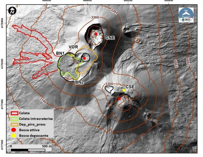
Fig. 3.1 Map of flows and proximal deposition emitted during the paroxysm of July 15, 2024, superimposed on the shaded terrain model obtained from drone surveys of May, June and July 2024. CSE = South-East Crater, CNE = North-East, BN=Bocca Nuova, VOR=Voragine. The contour lines every 100 m have an ellipsoid altitude.
On July 17, drone surveys were carried out on the North and South sides of Etna to map the volcanics from the July 15 eruptive event and update the topography of the summit craters. The surface covered by the additional flow of the crater is equal to 1.7 x 10^5 m2 (in red in Fig. 3.1); the surface covered by the intra-crater flow is equal to 0.8 x 10^5 m2 (in green in Fig. 3.1); the surface covered by the proximal pyroclastic deposit is equal to 0.8 x 10^5 m2 (in orange in Fig. 3.1). The front which has reached the minimum altitude is that of the North-West arm which rises to 2976 m above sea level (geoidal elevation obtained by subtracting 43 m from the ellipsoid elevation). The total volume, between flows and proximal pyroclastic deposit, is approximately 2 x 10^6 m3.
Images acquired by drone in the visible and thermal infrared domain made it possible to observe the state of the VOR and BN and CSE and CNE craters. In particular, on the CSE, the fumaroles located on the South-East and North-West spurs are clearly visible; the CNE images were acquired just before an explosion.
Source : INGV
Photos : Gio Giusa ( 23/07/2024) , INGV.
Japan , Sumisujima :
The Japan Coast Guard reported that an area of discolored water, brown to yellow-green in color, was visible about 300 m E of the E coast of Sumisujima on 18 July. The report noted that areas of discolored water had occasionally been seen in the vicinity of the island since 2017, though usually characterized as pale blue to white and smaller in size. Sailors were warned to exercise caution in the area.
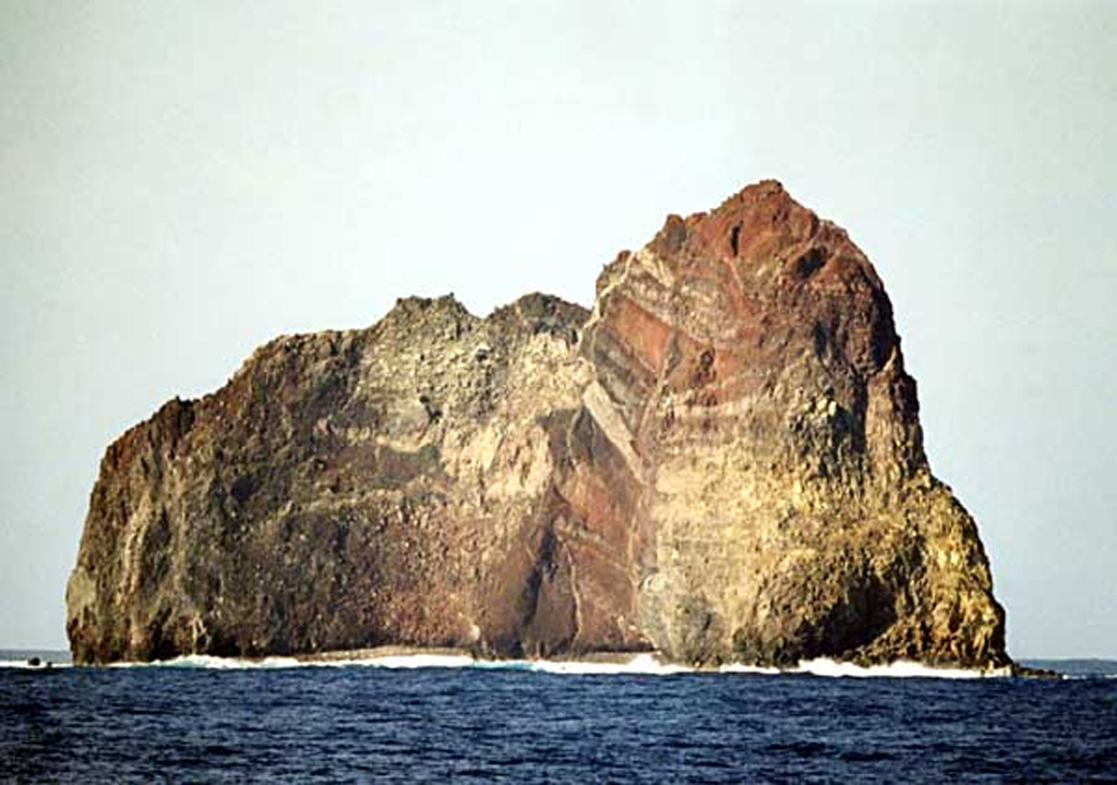
Wave erosion has exposed the spectacular stratigraphy of Sumisujima, a steep-sided pinnacle that is a remnant of the outer southern flank of a submarine caldera 6-9 km wide. Intrusive rocks, dikes, tephra layers, and breccias are visible in this view of the eastern side of the pinnacle.
Sumisujima (also known as Smith Rocks) is a steep-sided basaltic pinnacle that forms part of the outer southern flank of a 8-9 km wide submarine caldera that truncates a 20-km-wide seamount. The caldera was formed between about 60,000 and 30,000 years ago. The Shirane dacitic central cone, 3 km wide and 800 m high, rises to within 8 m of the ocean surface in the eastern side of the caldera, whose 600-700 m walls and outer flanks expose basaltic, andesitic, and rhyolitic rocks. Two large submarine cones, Sumisu Knolls No. 1 and 2, lie west of the caldera. Submarine eruptions have been reported from a number of locations near Sumisujima, the last of which occurred in 1916. Water discoloration has frequently been observed since the 1970’s. In October 1992 a 6-km-long zone of discolored water was seen extending from the shallow Shirane rock mass near the eastern rim of the caldera, which rises to within 7 m of the ocean surface and is the youngest feature of the volcanic complex.
Sources: Japan Coast Guard , GVP
Photo : Copyrighted photo by Kenichiro Tani, 2002 (Japanese Quaternary Volcanoes database, RIODB, http://riodb02.ibase.aist.go.jp/strata/VOL_JP/EN/index.htm and Geol Surv Japan, AIST, http://www.gsj.jp/).
Kamchatka , Bezymianny :
VOLCANO OBSERVATORY NOTICE FOR AVIATION (VONA)
Issued: July 24 , 2024
Volcano: Bezymianny (CAVW #300250)
Current aviation colour code: RED
Previous aviation colour code: orange
Source: KVERT
Notice Number: 2024-44
Volcano Location: N 55 deg 58 min E 160 deg 35 min
Area: Kamchatka, Russia
Summit Elevation: 2882 m (9452.96 ft)
Volcanic Activity Summary:
The strong explosive eruption of the Bezymianny volcano began at 15:10 UTC on 24 July. Explosions sent ash up to 9.6 km a.s.l., and later up to 12 km a.s.l. The large ash plume continues to move to the east-southeast of the volcano. Ashfalls do not threaten populated areas of the Kamchatka Kray.
The explosive eruption of the volcano continues. Ongoing activity could affect international and low-flying air craft.
Volcanic cloud height:
10000-12000 m (32800-39360 ft) AMSL Time and method of ash plume/cloud height determination: 20240724/1520Z – Himawari-9 14m15
Other volcanic cloud information:
Distance of ash plume/cloud of the volcano: 300 km (186 mi)
Direction of drift of ash plume/cloud of the volcano: ESE / azimuth 109 deg
Time and method of ash plume/cloud determination: 20240724/1930Z – Himawari-9 14m15
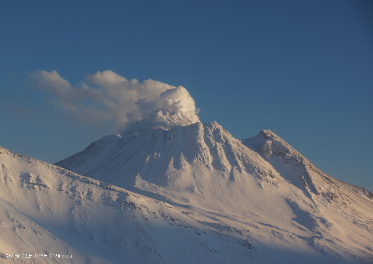
KVERT reported that lava extrusion at Bezymianny significantly increased on 21 July, causing collapses of the E part of the lava dome and subsequent hot avalanches of material. Ash plumes from the collapses rose 2-3 km a.s.l. On 22 July the Aviation Color Code was raised to Orange (the third level on a four-color scale). Activity was sustained at least through 24 July, and by then ash plumes were drifting 70 km SW. Dates and times are reported in UTC; specific events are in local time where noted.
Issued: July 25 , 2024
Volcanic Activity Summary:
The explosive eruption of the volcano ended, but the activity of the volcano continues. The ash plume, in a strip of 80 km width, continues to move to the southwest and southeast of the volcano. According to satellite data Himawari-9, at 23:40 UTC, the frontal parts of the plume were located at distances of 130 km to the southwest and 926 km to the southeast from the volcano.
Source : Kvert , GVP.
Photo : S. Chirkov, IVS FEB RAS ( archive 2023)
Indonesia , Ibu :
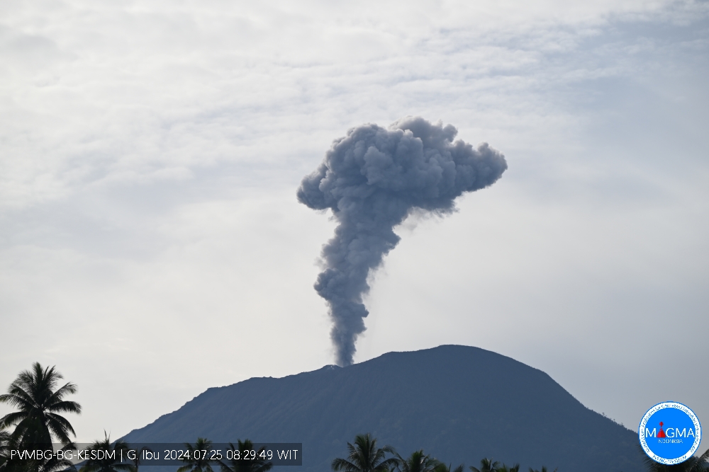
An eruption of Mount Ibu occurred on Thursday 25 July 2024 at 08:28 WIT with the height of the ash column observed at ±1000 m above the summit (±2325 m above sea level). The ash column was gray in color with a thick intensity, oriented towards the South-East. This eruption was recorded on a seismograph with a maximum amplitude of 28 mm and a duration of 141 seconds.
VOLCANO OBSERVATORY NOTICE FOR AVIATION – VONA
Issued : July 25 , 2024
Volcano : Ibu (268030)
Current Aviation Colour Code : ORANGE
Previous Aviation Colour Code : orange
Source : Ibu Volcano Observatory
Notice Number : 2024IBU173
Volcano Location : N 01 deg 29 min 17 sec E 127 deg 37 min 48 sec
Area : North Maluku, Indonesia
Summit Elevation : 4240 FT (1325 M)
Volcanic Activity Summary :
Eruption with volcanic ash cloud at 23h28 UTC (08h28 local).
Volcanic Cloud Height :
Best estimate of ash-cloud top is around 7440 FT (2325 M) above sea level or 3200 FT (1000 M) above summit. May be higher than what can be observed clearly. Source of height data: ground observer.
Other Volcanic Cloud Information :
Ash cloud moving to southeast. Volcanic ash is observed to be gray. The intensity of volcanic ash is observed to be thick.
Remarks :
Eruption recorded on seismogram with maximum amplitude 28 mm and maximum duration 141 second.
Source et photo : Magma Indonésie .
Hawaii , Kilauea :
Wednesday, July 24, 2024, 4:21 PM HST (Thursday, July 25, 2024, 02:21 UTC)
19°25’16 » N 155°17’13 » W,
Summit Elevation 4091 ft (1247 m)
Current Volcano Alert Level: ADVISORY
Current Aviation Color Code: YELLOW
SUMMARY OF ACTIVITY
An abrupt increase in seismicity accompanied by local deformation on July 22 at 11 a.m. HST marked the initial stage of magma intruding underground in the upper East Rift Zone (UERZ) of Kīlauea. This activity is concentrated between Pauahi Crater and Maunaulu along Chain of Craters Road in Hawaiʻi Volcanoes National Park.
A stronger pulse of seismicity and local deformation began on July 23 at 3:30 a.m. HST and was coincident with deflation of Kīlauea summit. The summit has been steadily deflating since then as magma moves into the vertical, sheet-like body (dike) beneath the UERZ near Pauahi Crater.
A third pulse of activity began today on July 24 at 10 a.m. HST as dike emplacement continues. Each pulse lasted approximately 2–3 hours, but seismicity and deformation continued at levels well above normal between the pulses.
In total, there have been nearly 1,000 earthquakes located in the UERZ of Kīlauea over the past 3 days; 250 of those earthquakes exceeded magnitude-2 and the largest event was a magnitude-3.6. Earthquakes have remained 1–3 km (0.6–1.8 miles) beneath the surface. As of 4:30 p.m. on July 24, the dike continues to grow, and unrest may continue to wax and wane with changes to the input of magma into the area. An eruption is not currently imminent, but conditions could change rapidly.
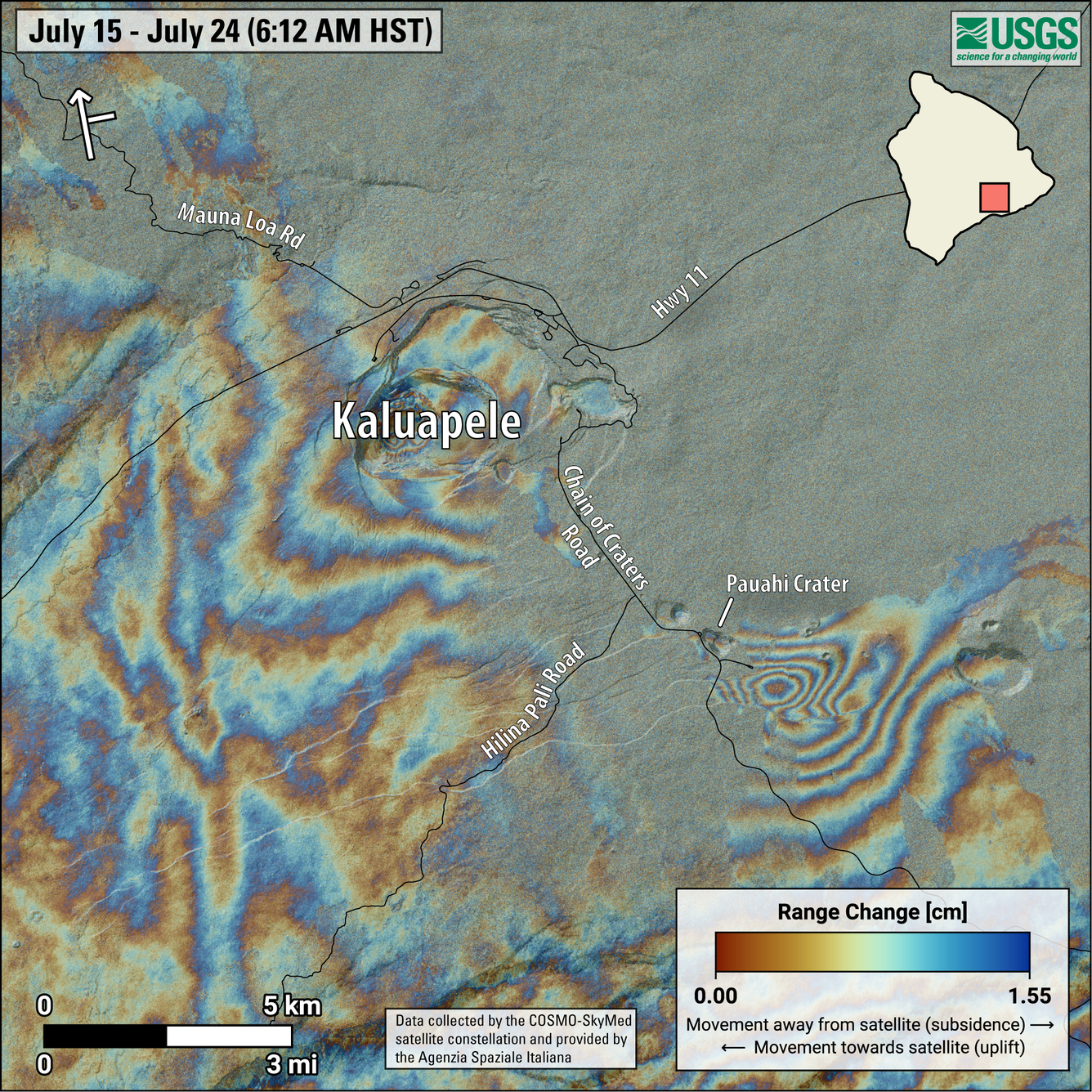
This map shows recent deformation at Kīlauea, over the timeframe of July 15-24, 2024. Data were recorded by the Italian Space Agency’s (ASI) Cosmo-SkyMED satellite. Colored fringes denote areas of ground deformation, with more fringes indicating more deformation. Each color cycle represents 1.5 cm (0.6 in) of ground motion. The bullseye feature southeast of Pauahi Crater on the upper East Rift Zone indicates inflation over this time period due to magma accumulation underground. Arrow in the upper left indicates satellite orbit direction (arrow) and look direction (bar).
Unrest has been restricted to UERZ; no unusual activity has been noted along Kīlauea’s middle and lower East Rift Zones or the Southwest Rift Zone. The USGS Hawaiian Volcano Observatory (HVO) continues to closely monitor Kīlauea for changes.
INTERPRETATION
The rapid onset and concentrated intensity of the July 22–24 UERZ swarm, coupled with abrupt changes in UERZ ground deformation patterns, show that an intrusion of magma is occurring in the area of Pauahi Crater. Deformation associated with emplacement of this dike is apparent on a satellite interferogram of the area, confirming ground-based observations. Ongoing seismicity, local deformation, and steady deflation of the summit region indicate that magma is continuing to move underground into the UERZ. The pulsing nature of this recent activity may represent fluctuations in the amount of magma moving underground from the summit to the UERZ.
Source et photo : HVO