July 08 , 2024.
Italy / Sicily , Etna :
DECLARATION OF VOLCANIC ACTIVITY of July 7, 2024 10:48:17 (UTC).
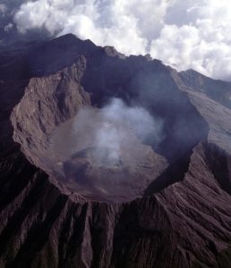
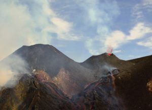
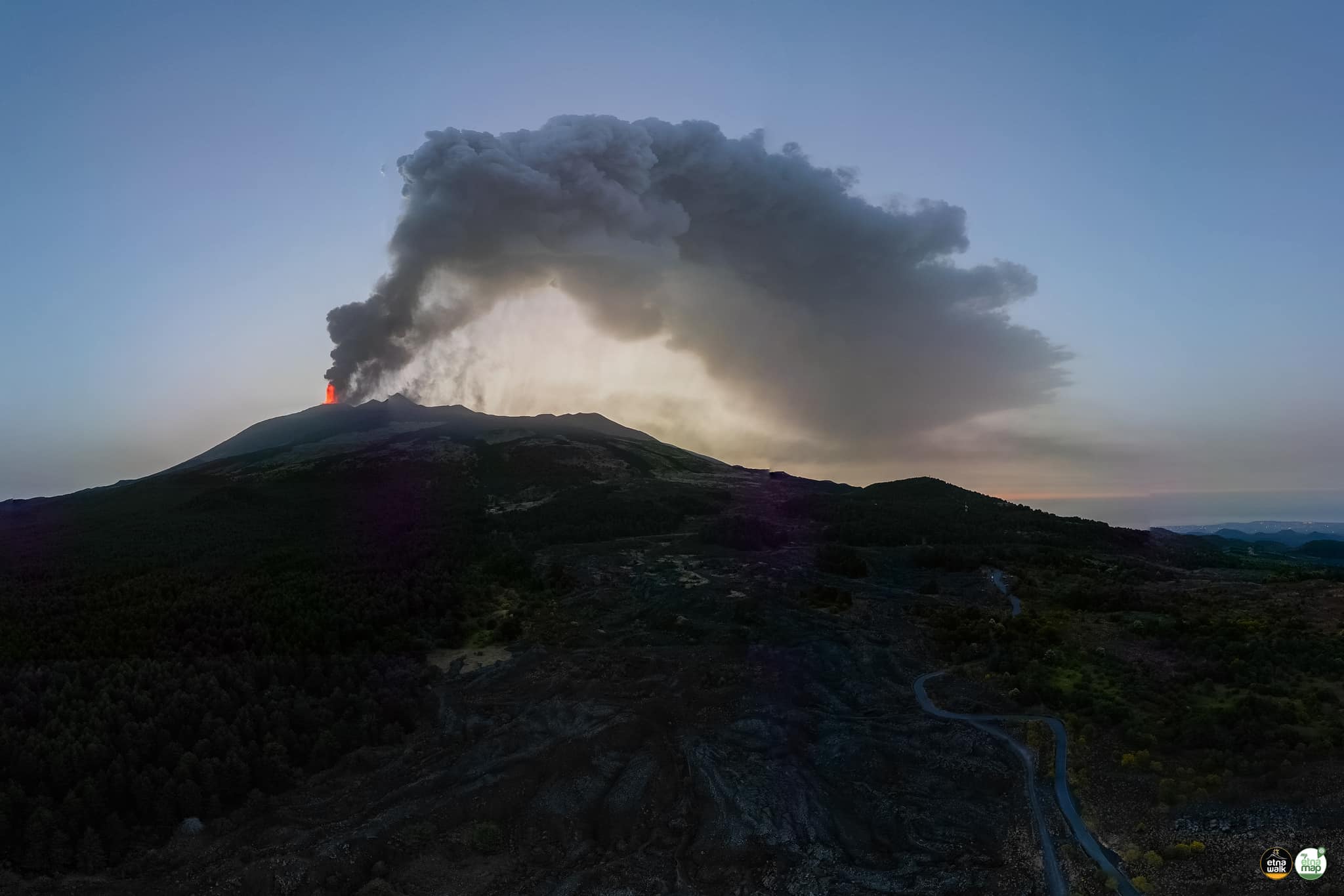
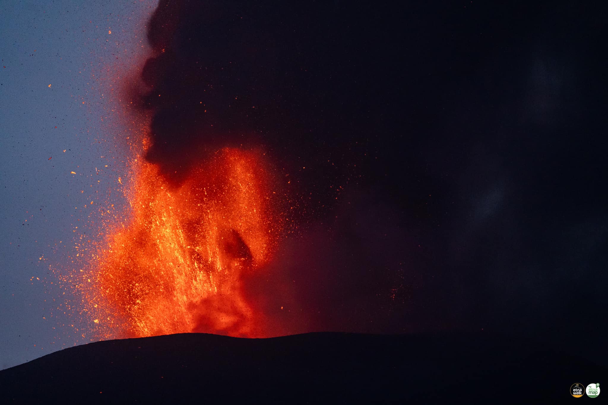
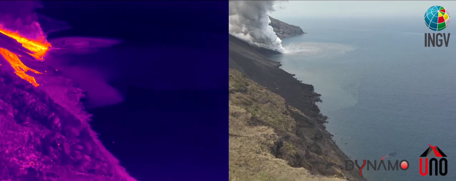
The National Institute of Geophysics and Volcanology, Osservatorio Etneo, communicates that, from the analysis of the INGV-OE surveillance cameras, it was observed that the activity of the lava fountain of the Voragine crater began around 02:00 UTC and, as noted in a previous announcement, has gradually weakened. then ceased around 08:00 UTC. After the end of paroxysmal activity, Strombolian activity continued for about an hour, which also gradually weakened. The paroxysmal activity produced an eruptive column at around 9,000 m altitude, which propagated eastwards, causing significant ash fall on several villages in the eastern area of Etna, along the Zafferana Etnea – Giarre axis. The activity also produced, at 06:50 UTC, a lava flow which currently appears to be fed and which overflowed from the northwest edge of the Bocca Nuova crater. The altitude of the front is approximately 3000 m above sea level. Sporadic emissions of ash from the Southeast crater were also observed, including one at 9:41 UTC, which quickly dispersed in the ‘atmosphere. Field investigations by INGV staff are underway.
The average amplitude of the volcanic tremor reached its maximum values between 03:00 and 06:20 UTC today. Subsequently, a rapid decrease in values was observed which, after some fluctuations, reached an average level at 09:50 UTC, where they are currently maintained with a downward trend. The center of the sources of the volcanic tremor during the phase of maximum amplitude was located in a volume to the east of the Voragine crater, at an altitude between approximately 2700 and 2900 m above sea level. Currently, the centroid is located in a joint area to the east of the Voragine-Southeast craters, at an altitude of approximately 2700-2800 m above sea level, with a tendency to move towards the South-East.
The amplitude of the infrasound events and the infrasound tremor remained at a high level until around 06:30 and were located in the Voragine crater. Subsequently, a rapid decrease was observed, also in the frequency of occurrence, until the cessation of infrasound events around 07:15 UTC and infrasound tremor around 08:50 UTC. Weak infrasound activity is currently observed at the Southeast crater.
Ground deformation analyzes reveal a cumulative decompression of approximately 190 nano-strains, measured by the Monte Ruvolo dilatometer from 01:30 UTC to approximately 06:30 UTC. The inclinometer network observes a deflation of the volcano which accompanied the activity, at numerous stations in the network, from medium altitudes (for example around 0.5 microradians at Monte Denza) to the summit stations, where a maximum of approximately 3.5 microradians is observed at Crater del Piano, from 02.00UTC to 06.30UTC with a more complex trend from 06.30UTC to 07.00UTC. The GNSS network seems to show a slight shift towards the southwest of the stations on the north side of the summit cone, compatible with a contraction of the crater zone.
Source : INGV
Photos : Etna Walk / Giuseppe Distefano / Marco Restivo.
Italy , Stromboli :
DECLARATION OF VOLCANIC ACTIVITY of July 7, 2024, 12:05:48 (UTC).
The National Institute of Geophysics and Volcanology, Osservatorio Etneo, communicates that INGV staff in the field observed an intensification of effusive activity on the Sciara del Fuoco, produced by two chimneys at an altitude of 485 m above sea level. above sea level and that the well-fed flow, reaching the coast, formed a small lava delta, currently expanding. The lava flow, coming into contact with seawater, causes the formation of a cloud of steam. We can also observe the rolling of incandescent blocks of lava which, falling into the sea, cause small phreatic explosions and modest oscillations of the water surface.
The average seismic tremor amplitude remained stable at medium-low values until approximately 10:25 UTC, when it showed a peak at medium values. Analysis of seismograms continues to highlight a low level of activity characterized essentially by signals linked to continuous episodes of rock rolling. Since yesterday late afternoon, low energy events have also been recorded, clearly visible at the STRA seismic station, with a maximum frequency around 5-6 Hz, which is currently under investigation.
Analyzes of ground deformation data show no changes other than ambient and background noise oscillations on the monitoring networks.
Source : INGV
Photos : INGV ( capture d’écran)
Kamchatka , Karymsky :
VOLCANO OBSERVATORY NOTICE FOR AVIATION (VONA)
Issued: July 07 , 2024
Volcano: Karymsky (CAVW #300130)
Current aviation colour code: ORANGE
Previous aviation colour code: orange
Source: KVERT
Notice Number: 2024-38
Volcano Location: N 54 deg 2 min E 159 deg 26 min
Area: Kamchatka, Russia
Summit Elevation: 1486 m (4874.08 ft)
Volcanic Activity Summary:
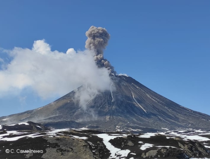
The explosive activity of the Karymsky volcano continues. Satellite data by KVERT showed explosions sent ash up to 4 km a.s.l., and an ash plume is extending for 36 km to the northeast of the volcano.
A moderate explosive activity of the volcano continues. Ash explosions up to 10 km (32,800 ft) a.s.l. could occur at any time. Ongoing activity could affect international and low-flying aircraft.
Volcanic cloud height:
4000 m (13120 ft) AMSL Time and method of ash plume/cloud height determination: 20240707/2140Z – Himawari-9 14m15
Other volcanic cloud information:
Distance of ash plume/cloud of the volcano: 36 km (22 mi)
Direction of drift of ash plume/cloud of the volcano: NE / azimuth 40 deg
Time and method of ash plume/cloud determination: 20240707/2220Z – Himawari-9 14m15
Source : Kvert
Photo : S. Samoylenko.
Indonesia , Marapi :
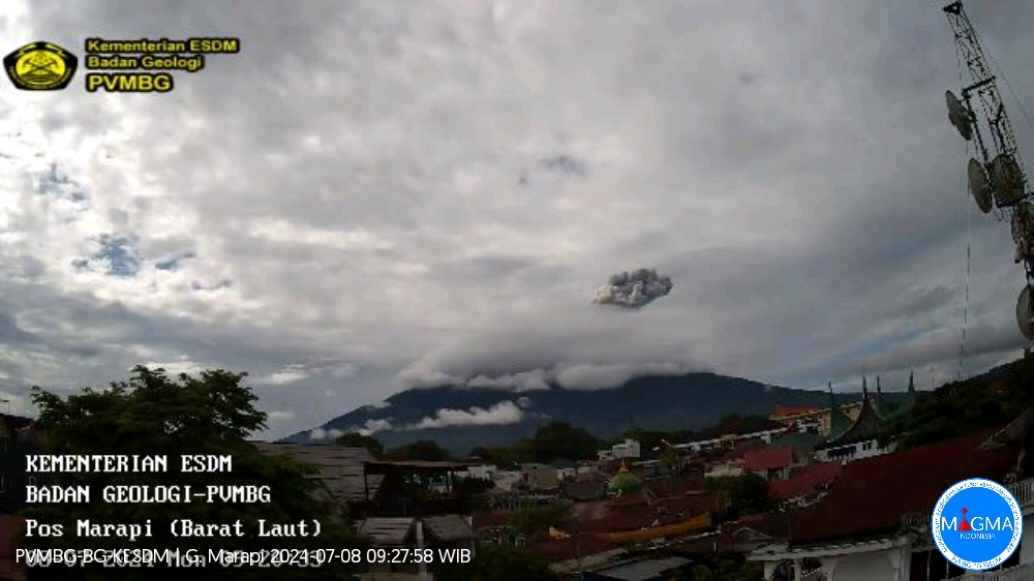
An eruption of Mount Marapi occurred on Monday, July 8, 2024 at 09:17 WIB with the height of the ash column observed at ± 1000 m above the summit (± 3891 m above sea level). The ash column was observed to be gray with thick intensity, oriented towards the South-West. This eruption was recorded on a seismograph with a maximum amplitude of 15.9 mm and a duration of 34 seconds.
VOLCANO OBSERVATORY NOTICE FOR AVIATION – VONA
Issued : July 08 , 2024
Volcano : Marapi (261140)
Current Aviation Colour Code : ORANGE
Previous Aviation Colour Code : orange
Source : Marapi Volcano Observatory
Notice Number : 2024MAR069
Volcano Location : S 0 deg 22 min 52 sec E 100 deg 28 min 23 sec
Area : West Sumatra, Indonesia
Summit Elevation : 9251 FT (2891 M)
Volcanic Activity Summary :
Eruption with volcanic ash cloud at 02h17 UTC (09h17 local).
Volcanic Cloud Height :
Best estimate of ash-cloud top is around 12451 FT (3891 M) above sea level or 3200 FT (1000 M) above summit. May be higher than what can be observed clearly. Source of height data: ground observer.
Other Volcanic Cloud Information :
Ash cloud moving to southwest. Volcanic ash is observed to be gray. The intensity of volcanic ash is observed to be thick.
Remarks :
Eruption recorded on seismogram with maximum amplitude 15.9 mm and maximum duration 34 second.
Source et photo : Magma Indonésie
Ecuador , Reventador :
DAILY REPORT ON THE STATE OF REVENTADOR VOLCANO, Sunday July 7, 2024.
Information Geophysical Institute – EPN.
Surface activity level: High, Surface trend: No changes
Internal activity level: Moderate, Internal trend: No changes
Seismicity: From July 6, 2024, 11:00 a.m. to July 7, 2024, 11:00 a.m.:
Seismicity:
Below is the count of seismic events recorded at the reference station
Explosion (EXP) 75
Long Period (LP) 5
Transmitting Tremor (TREMI) 6
Harmonic Tremor (TRARM) 5
Precipitation/Lahars:
Yesterday afternoon, rain was recorded in the volcano area without generating mud or debris flows. **In the event of heavy rains, these could remobilize the accumulated materials, generating mud and debris flows which would descend the sides of the volcano and flow into adjacent rivers.
Emissions/ash column:
It was not possible to identify gas and/or ash emissions using the surveillance camera system or satellite images, due to poor weather conditions. For its part, the Washington VAAC agency has not published any reports for this volcano either.
Observation:
During the night of yesterday and early today, thanks to the surveillance camera system, several episodes of incandescence and descent of incandescent materials on the flanks of the volcano were recorded, up to 800 meters below the level of the crater. . At the time of closing this report, the volcano remains cloudy
Alert Level: Orange
Source et photo : IGEPN.
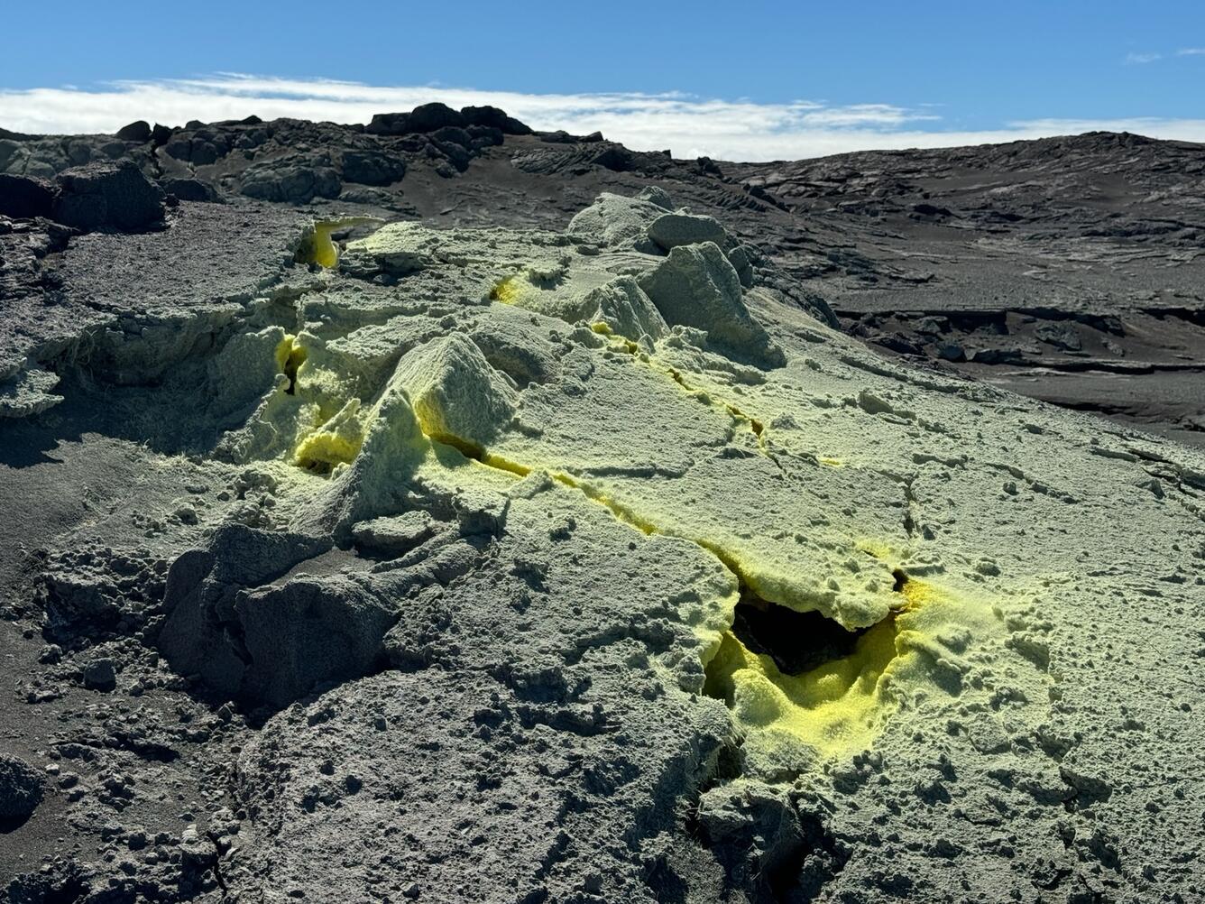
Hawaii , Kilauea :
Sunday, July 7, 2024, 8:05 AM HST (Sunday, July 7, 2024, 18:05 UTC)
19°25’16 » N 155°17’13 » W,
Summit Elevation 4091 ft (1247 m)
Current Volcano Alert Level: ADVISORY
Current Aviation Color Code: YELLOW
Activity Summary:
Kīlauea volcano is not erupting. Aftershocks continue following the M4.1 Kīlauea south flank earthquake that occurred at 8:47 p.m. HST last night. Earthquake counts in the upper East Rift Zone remain above background and increased slightly over the past 24 hours. Longer-term, gradual inflation of the summit and upper rift zones persists since the end of the June 3, 2024, eruption. Any substantial increases in seismicity and/or deformation could result in a new eruptive episode, but there are no signs of an imminent eruption at this time.
Summit and Upper Rift Zone Observations:
Over the past 24 hours, there were approximately 25 earthquakes detected beneath Kaluapele (Kīlauea caldera) and 95 earthquakes detected beneath the upper East Rift Zone, mostly at depths of 1–3 km (0.6–1.8 mi) beneath the ground surface. The number of upper East Rift Zone events is increased compared to the past several days (which each had around 20 events per day) but remains well below the counts recorded during the June 27–July 1 upper East Rift Zone swarm. Tiltmeters in Kīlauea summit region show no change in inflationary ground deformation rates over the past day: the SDH instrument southwest of the summit recorded approximately 4 microradians of inflationary tilt and the UWE instrument northwest of the summit qualitatively shows minor inflationary tilt (about a microradian, see the monitoring notice below). GPS instruments around the summit region continue to show longer-term, gradual inflation since the end of the June 3, 2024, eruption. The most recent measurement of the summit’s SO2 emission rate was approximately 75 tonnes per day on June 28, 2024.
Source : HVO
Photo : USGS / M. Patrick.