September 26 , 2025.
Kamchatka , Karymsky :
VOLCANO OBSERVATORY NOTICE FOR AVIATION (VONA)
Issued: September 26 , 2025
Volcano: Karymsky (CAVW #300130)
Current aviation colour code: YELLOW
Previous aviation colour code: orange
Source: KVERT
Notice Number: 2025-95
Volcano Location: N 54 deg 2 min E 159 deg 26 min
Area: Kamchatka, Russia
Summit Elevation: 1486 m (4874.08 ft)
Volcanic Activity Summary:
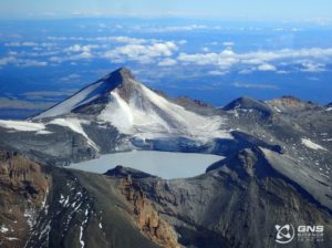
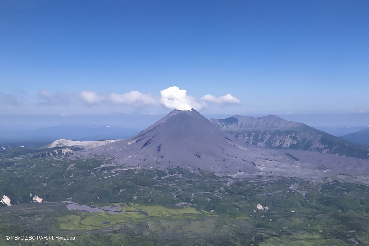
Moderate gas-steam activity of the volcano continues. Last explosions of the volcano were ovserving on 13-14, and 26-27 August, 2025. Only a gas-steam activity, and a weak thermal anomaly on the volcano were observed in September. KVERT continues to monitor Karymsky volcano.
Moderate activity of the volcano continues. The danger of ash explosions up to 6 km (19,700 ft) a.s.l. remains. Ongoing activity could affect low-flying aircraft.
Volcanic cloud height:
NO ASH CLOUD PRODUSED
Other volcanic cloud information:
NO ASH CLOUD PRODUSED
Source : Kvert .
Photo : Ivan Nuzhdaev, IVS FEB RAS.
Hawaii , Kilauea :
HAWAIIAN VOLCANO OBSERVATORY DAILY UPDATE , U.S. Geological Survey
Thursday, September 25, 2025, 7:55 AM HST (Thursday, September 25, 2025, 17:55 UTC)
19°25’16 » N 155°17’13 » W,
Summit Elevation 4091 ft (1247 m)
Current Volcano Alert Level: WATCH
Current Aviation Color Code: ORANGE
Activity Summary:
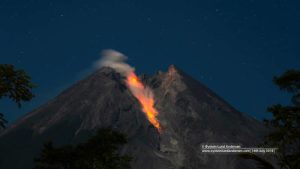
Episode 33 lava fountaining ended on Friday, September 19. Glow from the vents was observed overnight, especially from south vent. The summit is reinflating, and models indicate that episode 34 is likely to start between September 28 and October 1. No significant activity has been noted along Kīlauea’s East Rift Zone or Southwest Rift Zone.
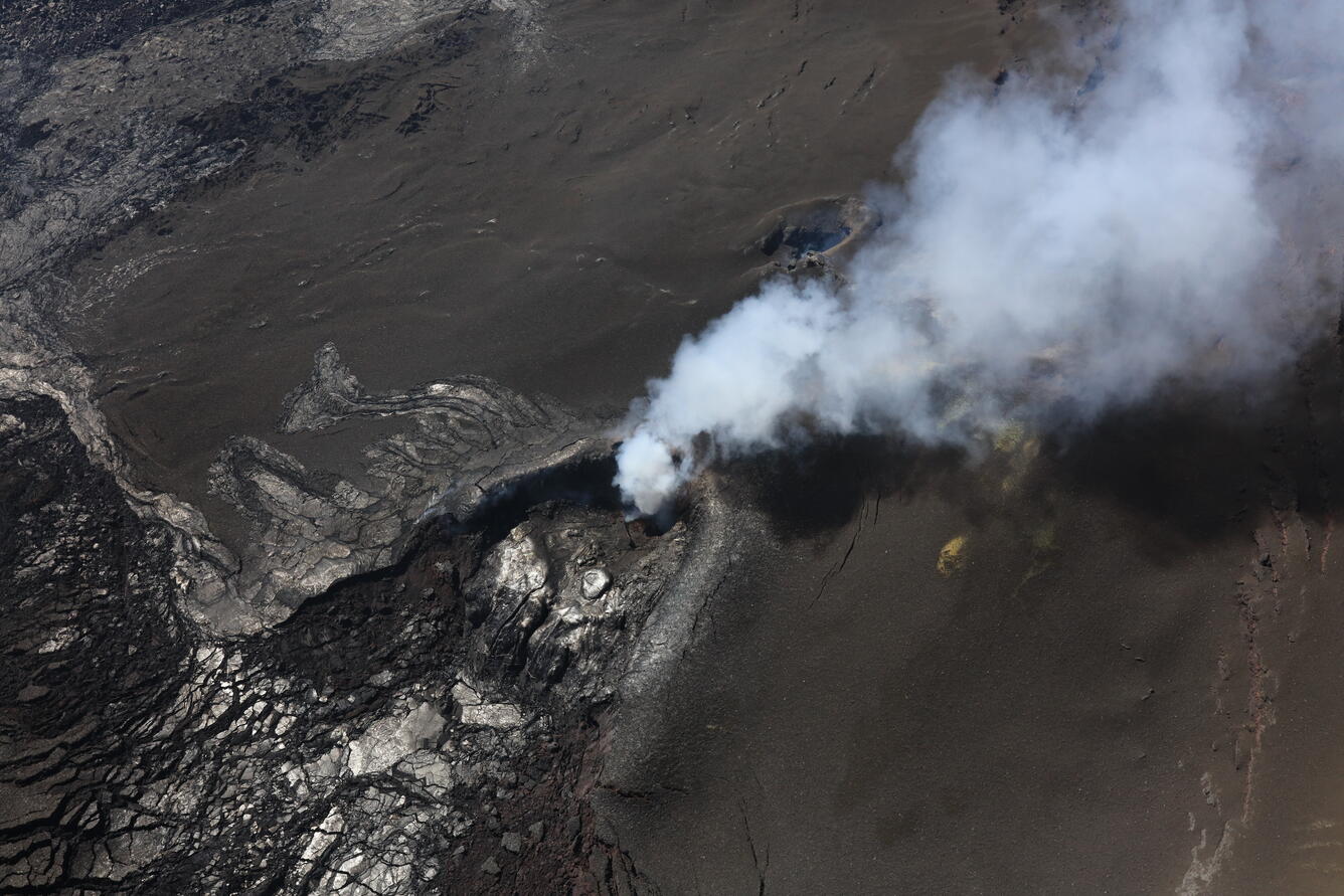
USGS Hawaiian Volcano Observatory scientists took this oblique angle view of north (center) and south vents (to the right and closer to top of photo) during a Kīlauea summit monitoring overflight on September 24. The brown sand-like material that covers the right and top parts of the photo are tephra erupted during episode 33. South vent was only active towards the beginning of the episode 33, and so north vent tephra from the later portion of episode 33 covers the lava flow from south vent. No lava was seen at the bottom of either vent.
Summit Observations:
Episode 33 lava fountaining ended at 12:08 p.m. HST on Friday, September 19. The UWD tiltmeter shows that the summit has been reinflating since the end of the fountaining episode, with a bit more than 11 microradians of inflationary tilt. A helicopter overflight yesterday morning reported no visible lava within the vents. Overnight, HVO webcams showed that intermittent glow was present in the south and north vents. This morning, the caldera is quiet with a passive outgassing plume rising from the vents.
Elevated degassing continues from the vent. Average sulfur dioxide (SO2) emission rates during pauses are typically 1,200 to 1,500 t/d, though emission rates can vary on short time scales.
Source : HVO
Photo : USGS / N. Deligne
Indonesia , Ili Lewotolok :
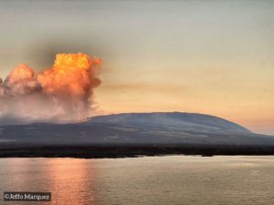
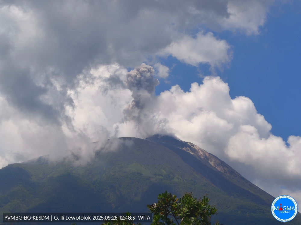
An eruption of Mount Ili Lewotolok occurred on Friday, September 26, 2025, at 12:47 WITA. An ash column was observed about 500 m above the summit (about 1,923 m asl). The observed ash column was white to gray, with a strong intensity directed toward the west. This eruption was recorded by seismograph with a maximum amplitude of 15.2 mm and a duration of 63 seconds.
Seismic Observations
72 eruption earthquakes with amplitudes ranging from 4.3 to 32.3 mm and durations ranging from 36 to 84 seconds.
70 emission earthquakes with amplitudes ranging from 1.4 to 6.3 mm and durations ranging from 25 to 45 seconds.
3 nonharmonic tremors with amplitudes ranging from 1.5 to 15.6 mm and durations ranging from 125 to 244 seconds.
1 deep volcanic earthquake with an amplitude of 30 mm and durations ranging from 10 seconds.
Recommendations
At Activity Level III (SIAGA):
[1] Residents of the vicinity of Mount Ili Lewotolok, as well as visitors, climbers, and tourists, are advised not to enter or participate in activities within a 3 km radius of the Mount Ili Lewotolok activity center. Residents are advised to be aware of the potential dangers of lava avalanches and hot clouds emanating from the southern, southeast, western, and northeast sectors of Mount Ili Lewotolok.
(2) The public is advised not to panic if they hear rumbling sounds coming from the crater of Mount Ili Lewotolok, as these sounds are a sign of volcanic activity in the eruptive phase. These rumbling sounds can cause severe vibrations in some parts of buildings, particularly windows and glass doors.
Source et photo : Magma Indonésie .
Chile , Tupungatito :
Special Volcanic Activity Report (REAV)
Santiago Metropolitan Region, Tupungatito Volcano, September 24, 2025, 8:40 PM local time (Continental Chile)
The National Geology and Mining Service of Chile (Sernageomin) releases the following preliminary information, obtained using the monitoring equipment of the National Volcanic Monitoring Network (RNVV), processed and analyzed at the Volcanological Observatory of the Southern Andes (OVDAS):
Today, Wednesday, September 24, at 8:19 PM local time (23:19 UTC), monitoring stations installed near the Tupungatito Volcano recorded an earthquake associated with the movement of very low-frequency (Very Long Period) fluids.
The earthquake characteristics, after analysis, are as follows:
TIME OF ORIGIN: 8:19 PM local time (11:19 PM UTC)
LOCATION: Origin of the volcanic edifice
DEPTH: Undetermined
Frequency: 0.31 Hz
Reduced Displacement (RD): 99 cm²
OBSERVATIONS:
At the time of this email, no other seismic events associated with the volcano’s internal dynamics have been recorded.
The technical volcanic alert is still in effect at:
Technical Volcanic Alert GREEN
Source et photo: Sernageomin
Colombia , Galeras :
San Juan de Pasto, September 23, 2025, 3:00 p.m.
Regarding the monitoring of the activity of the Galeras Volcano, the Colombian Geological Survey (SGC), an entity attached to the Ministry of Mines and Energy, reports that:
During the week of September 16 to 22, 2025, the main variations in the monitored parameters compared to the previous week were:
• An increase in seismic activity and energy release was recorded, but the latter remained low. Seismicity associated with rock fracturing
remains predominant.
• Most events were located near the main crater, less than 7.0 km and at a depth of less than 8.0 km from the summit, at an altitude of 4,200 m, and with low energy levels. The largest event occurred 6.2 km to the west, at a depth of 7.3 km, and its magnitude was 1.9.
• Low-lying columns of white gas were observed, mainly coming from the fumarole fields of El Paisita (North) and Las Chavas (West). Their dispersion varied depending on wind direction and speed.
• Other volcanic monitoring parameters showed stability.
In view of the above, the SGC recommends closely monitoring developments through weekly bulletins and other information published through our official channels, as well as instructions from local and departmental authorities and the National Disaster Risk Management Unit (UNGRD).
Volcanic activity remains on yellow alert: active volcano with changes in the baseline behavior of monitored parameters and other manifestations.
Source et photo : SGC