June 17 , 2025.
Hawaii , Kilauea :
Monday, June 16, 2025, 8:49 AM HST (Monday, June 16, 2025, 18:49 UTC)
19°25’16 » N 155°17’13 » W,
Summit Elevation 4091 ft (1247 m)
Current Volcano Alert Level: WATCH
Current Aviation Color Code: ORANGE
Activity Summary:
The ongoing Halema‘uma‘u eruption is currently paused. Summit inflation continues, along with persistent, low level seismic tremor. Glow was visible overnight at the north and south vents. The fountaining phase of episode 26 will likely begin between June 18 and 20, 2025, based on current rates of summit inflation. This window is subject to change depending on changes in the rate of inflationary tilt. The fountaining phase could be preceded by hours to days of precursory gas-pistoning activity.
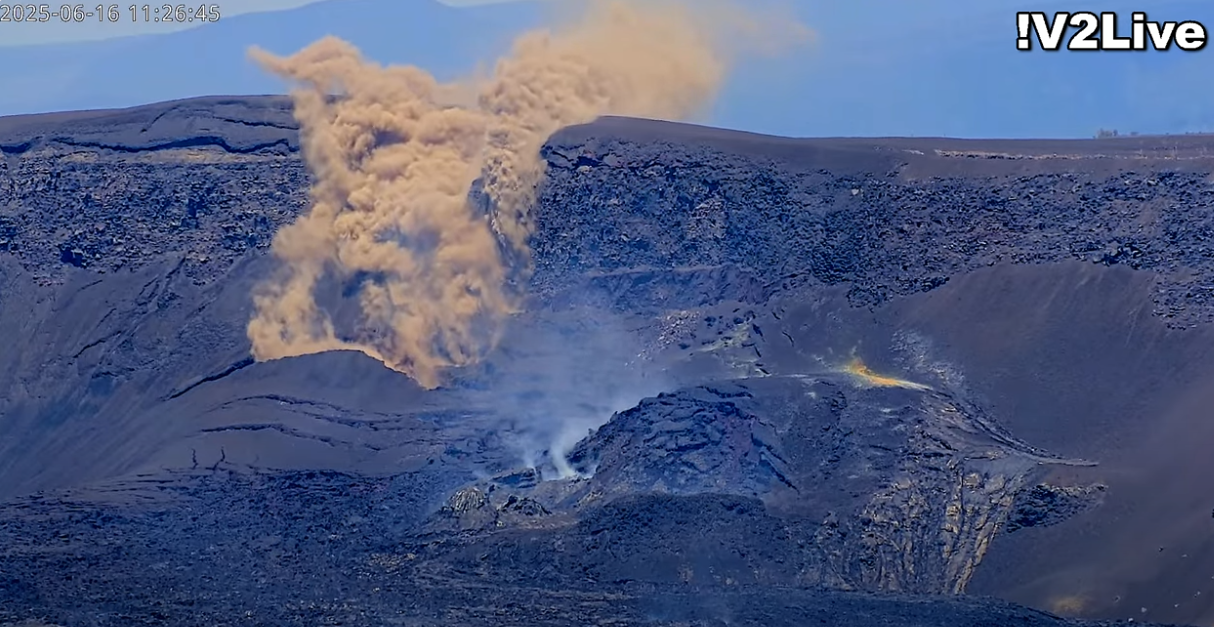
Large Rock Slide/Fall captured on USGS V2 Live Camera
Fountaining episodes have occurred approximately once per week since the start of the eruption on December 23, 2024. All eruptive activity remains within Hawaiʻi Volcanoes National Park. No significant activity has been noted along Kīlauea’s East Rift Zone or Southwest Rift Zone. Current hazards include ongoing volcanic gas emissions and potential remobilization volcanic glass (Pele’s hair) and tephra deposited during past episodes in the Kīlauea summit region of Hawaiʻi Volcanoes National Park and nearby communities.
Summit Observations:
Overnight, incandescence at both the north and south vents in Halemaʻumaʻu was visible in the V3cam. Degassing also continues from both the north and south vents.
The average sulfur dioxide (SO2) emission rate during inter-episode pauses, such as the ongoing pause, is typically around 1,200 tonnes per day (t/d).
Summit tiltmeters have continued to record inflationary tilt following the end of episode 25. A tiltmeter near Uēkahuna (UWD) has recovered about 10 microradians of inflationary tilt since the end of episode 25.
Source et photo : HVO.
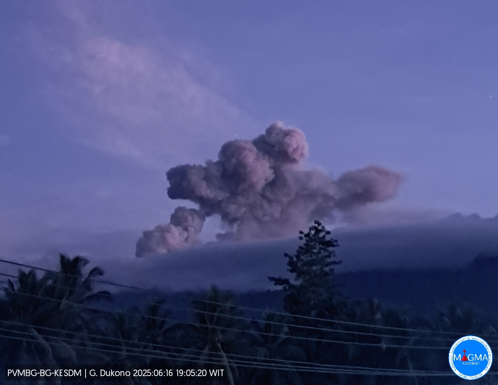
Indonesia , Dukono :
Mount Dukono erupted on Sunday, June 15, 2025, at 5:25 PM (local time). The observed ash column was ± 2,500 m above the summit (± 3,587 m above sea level). The ash column was gray and of strong intensity, oriented northwest. At the time of this report, the eruption was still ongoing.
VOLCANO OBSERVATORY NOTICE FOR AVIATION – VONA
Issued : June 15 , 2025
Volcano : Dukono (268010)
Current Aviation Colour Code : ORANGE
Previous Aviation Colour Code : orange
Source : Dukono Volcano Observatory
Notice Number : 2025DUK150
Volcano Location : N 01 deg 41 min 35 sec E 127 deg 53 min 38 sec
Area : North Maluku, Indonesia
Summit Elevation : 3478 FT (1087 M)
Volcanic Activity Summary :
Eruption with volcanic ash cloud at 08h25 UTC (17h25 local).
Volcanic Cloud Height :
Best estimate of ash-cloud top is around 11478 FT (3587 M) above sea level or 8000 FT (2500 M) above summit. May be higher than what can be observed clearly. Source of height data: ground observer.
Other Volcanic Cloud Information :
Ash cloud moving to southwest. Volcanic ash is observed to be white to gray. The intensity of volcanic ash is observed to be thick.
Remarks :
Eruption and ash emission is continuing. Eruption recorded on seismogram with maximum amplitude 15 mm. Tremor recorded on seismogram with maximum amplitude 3 mm.
Source et photo : Magma Indonésie .
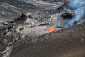
Alaska , Great Sitkin :
Lava continues to erupt slowly in the summit crater of Great Sitkin Volcano. Seismicity remains at low levels with occasional small earthquakes detected, including signals possibly caused by small rockfalls from the growing summit lava dome. Weakly elevated surface temperatures were seen in one satellite view over the last 24 hours. Webcam views were obscured by clouds.
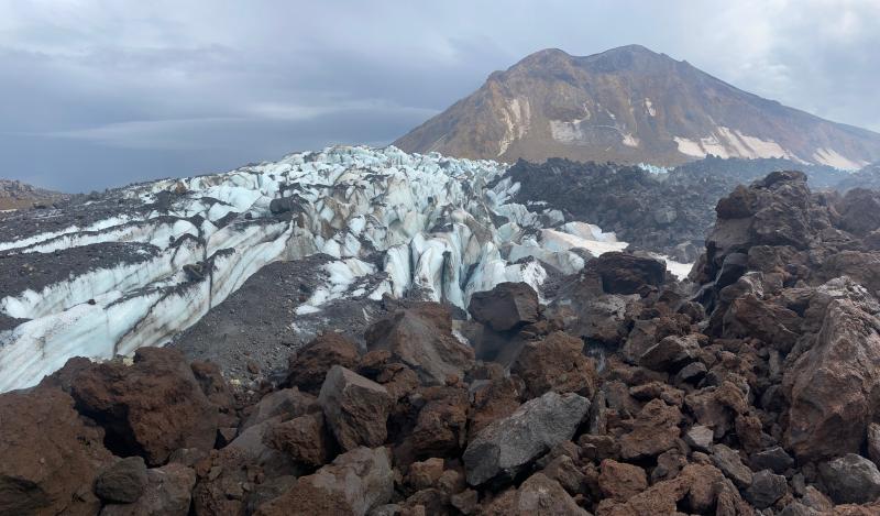
Lava-ice contact of the 2021-2023 Great Sitkin lava flows. Foreground lavas were inactive and emplaced in Fall 2021 through mid 2022, while the darker lobe in the middle-right was active and emplaced mid 2022-2023. The summit of Great Sitkin is visible in the upper right.
The current eruption of Great Sitkin Volcano began with a single explosive event in May 2021. The ongoing eruption of lava at the summit began shortly afterward, in July 2021. The volcano is monitored using local seismic and infrasound sensors, satellite data and web cameras, and regional infrasound and lightning networks.
Source : AVO
Photo : Loewen, Matthew AVO/USGS.
Guatemala , Fuego :
Weather conditions: Cloudy.
Wind: East.
Precipitation: 26.2 mm.
Activity:
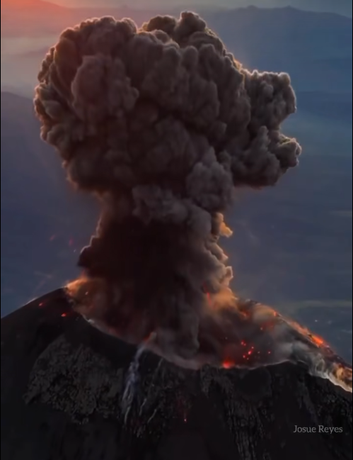
The Fuego Volcano Observatory reports cloudy weather, making observation of volcanic activity difficult. No rumbling or other noise has been heard. Seismic and infrasound sensors have not recorded any explosions since the night of June 10. Webcams revealed a glow in the crater for brief periods in the early morning. No ashfall has been reported in the communities surrounding the volcano.
Explosive activity could occur again at any time, ejecting columns of gas and ash. It could also cause incandescent rock fragments to fall around the crater. It is therefore recommended to stay away from this area to avoid burns and other serious or even fatal injuries. In the afternoon and evening, rains could cause lahars in the volcano’s various ravines, particularly in Ceniza, Santa Teresa, and El Jute.
Source : Insivumeh .
Photo : Josue Reyes ( capture d’écran).
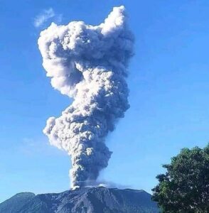
Peru , Sabancaya :
Analysis period: June 1, 2025 to June 15, 2025, Arequipa, June 16, 2025
Alert level: YELLOW
The Peruvian Geophysical Institute (IGP) reports that eruptive activity at the Sabancaya Volcano remains at a low level. During this period, an average of 0 daily explosions was recorded, with only columns of ash and gas up to 1,500 m above the volcano’s summit. Therefore, the volcanic alert level remains at Yellow.
The IGP recorded and analyzed the occurrence of 79 volcanic earthquakes, associated with the circulation of magmatic fluids within the Sabancaya Volcano, as well as earthquakes related to rock fracturing. No explosions were recorded during this period.

Columns of ash and gas were observed up to 1,500 m above the volcano’s summit. The predominant direction of these emissions was toward the northeast, east, and southeast of the volcano over a distance of less than 10 km.
No significant deformation of the volcanic edifice was recorded.
No thermal anomalies were identified.
Moderate emissions (235 tons/day) of sulfur dioxide (SO2) were observed.
RECOMMENDATIONS
• Maintain the Yellow Volcanic Alert Level.
• Do not approach within a radius of 6 km of the crater.
Source et photo : Cenvul