April 19 , 2025 .
Italy / Sicily , Etna :
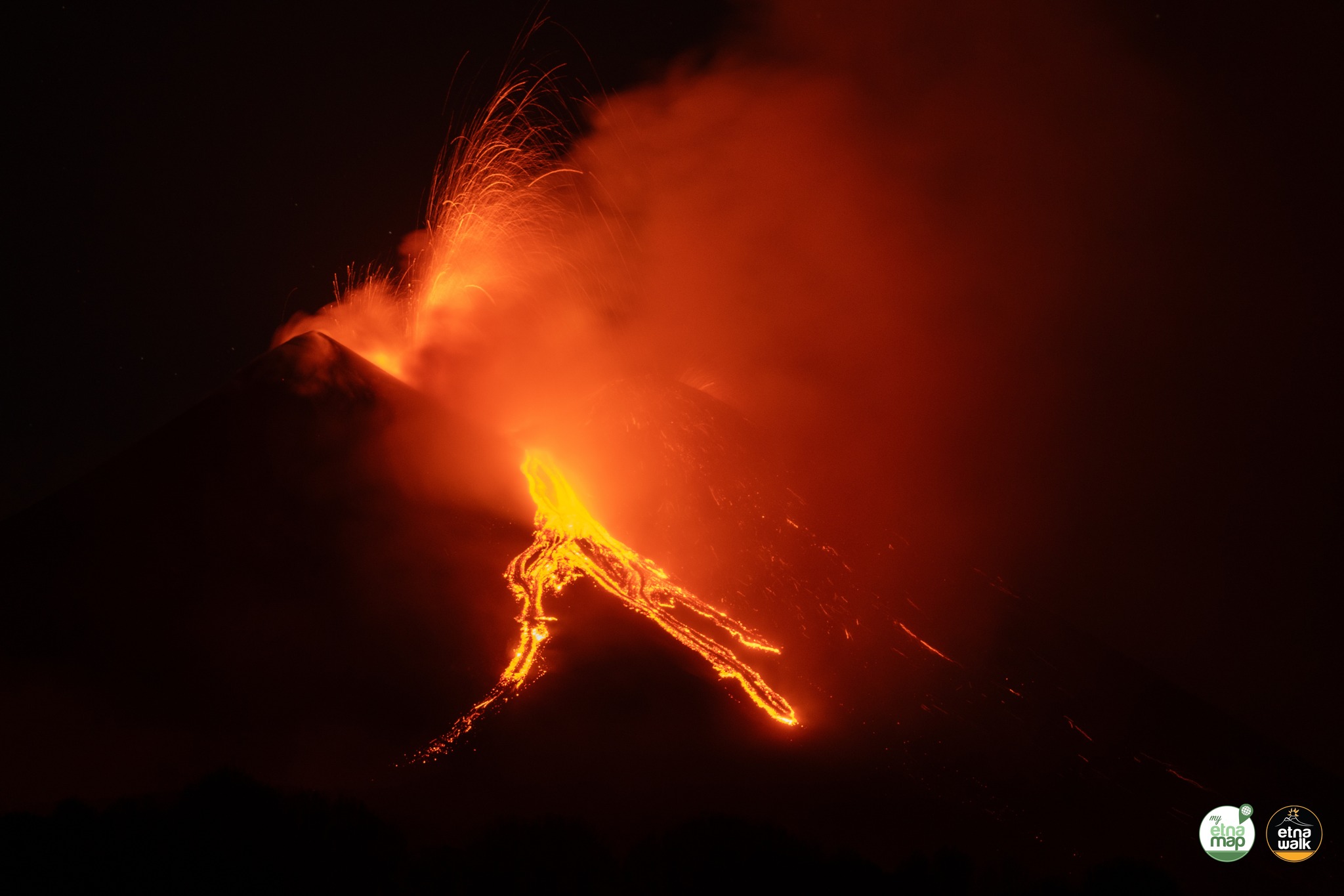
Etna Activity Report, April 18, 2025, 7:40 PM (5:40 PM UTC).
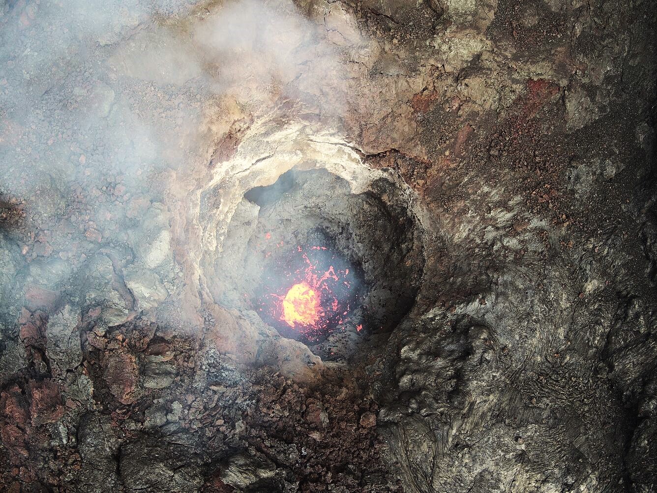
The National Institute of Geophysics and Volcanology, Osservatorio Etneo, announces that, starting around 5:05 PM GMT, Strombolian activity was observed by INGV-OE surveillance cameras at the Southeast Crater. The forecast model indicates that any eruptive clouds produced by the ongoing activity would disperse in an east-southeast direction.
From a seismic perspective, the amplitude of the volcanic tremor from 12:00 PM UTC today showed a continuous increase, reaching high values at 5:00 PM UTC. Tremor source locations are not available due to technical issues, but the tremor trend is consistent with movement toward the southeast crater at an altitude of approximately 2,900 meters above sea level. Counting and localizing infrasound events is unreliable due to strong winds in the summit area.
At the time of writing, ground deformation monitoring networks show no significant changes in GNSS and inclinometer sensors.
Further updates will be provided shortly.
Source : INGV
Photos : Etna walk / Giuseppe Distefano / Marco Restivo .
Hawaii , Kilauea :
Friday, April 18, 2025, 9:22 AM HST (Friday, April 18, 2025, 19:22 UTC)
19°25’16 » N 155°17’13 » W,
Summit Elevation 4091 ft (1247 m)
Current Volcano Alert Level: WATCH
Current Aviation Color Code: ORANGE
Activity Summary:
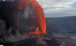
The ongoing Halemaʻumaʻu eruption remains paused, with glow visible from its vents over night. Episode 18 precursory activity of spattering and a north vent overflow occurred on April 16 from 9:10 p.m. to 11:21 p.m. HST. The main lava fountaining phase of episode 18 is most likely to start sometime on Saturday or Sunday, but could start as early as today or as late as Monday. It is possible that more lava flows could precede the fountaining phase.
Kīlauea’s current eruption in Halemaʻumaʻu crater within Kaluapele (the summit caldera) began on December 23, 2024. There have now been 18 episodes separated by pauses in activity. All eruptive activity remains within Hawaiʻi Volcanoes National Park. No significant activity has been noted along Kīlauea’s East Rift Zone or Southwest Rift Zone. Current hazards include volcanic gas emissions and windblown volcanic glass (Pele’s hair) and tephra that have impacted Hawaiʻi Volcanoes National Park and nearby communities.
Summit Observations:
The south and north vents had significant glow for most of last night, but no spattering was observed. Strong degassing is currently occurring from both vents.
Low level activity began around 9:10 p.m. HST on April 16, with bursts of spatter every 10-20 seconds from the north vent, reaching up to a few meters (several feet) high. Spatter bursts continued to increase in size and frequency until about 9:30 p.m. HST when 10-15 foot high (3-5 meters high) dome fountains began. Lava overflowed from the north vent around 10:01 p.m. HST and fed a small lava flow that reached about 100 meters (a few hundred feet) from the vent. This activity ended abruptly at 11:21 p.m. HST. Glow from south vent disappeared when north vent had overflows but returned once north vent flows ceased. This is considered precursory activity to the main fountaining phase of episode 18 and there could be more lava flows preceding the fountaining phase.
The UWD and SDH tiltmeters continue to show an inflationary signal that has been persistent since the end of episode 17. The main fountaining phase of episode 18 is not expected to begin until deflation starts at the UWD and SDH tiltmeters. As of this morning, UWD has measured approximately 14 microradians of inflationary tilt since 9:45 a.m. HST April 9. Seismic tremor rapidly increased in intensity on April 16 with the north vent spattering and lava overflows but has since dropped to pre-overflow levels. Cyclic tremor patterns with 30-60 minute periods began at this time and continue to the present. These tremor patterns are reminiscent of cyclic patterns due to gas pistoning seen prior to episodes 14 and 15 but are longer period.
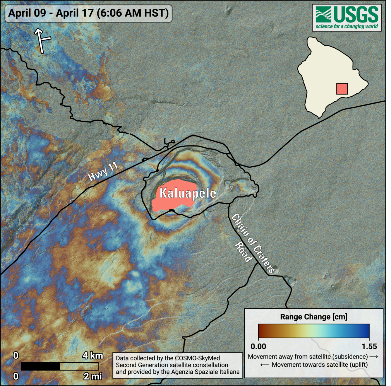
This map shows deformation at Kīlauea volcano associated with the ongoing summit eruption that started on December 23, 2024. The image covers the timespan from April 9–17, 2025, using data recorded by the Italian Space Agency’s (ASI) COSMO-SkyMed Second Generation satellite constellation. Colored fringes denote areas of ground deformation, with more fringes indicating more deformation. Each color cycle represents 1.5 centimeters (0.6 inches) of range change. The symbol in the upper left indicates the satellite’s orbit direction (arrow) and look direction (bar). The round fringes within and around Kaluapele (Kīlauea summit caldera) indicate ground surface inflation over this time period (during the pause between episodes 17 and 18) as magma accumulates in the Halemaʻumaʻu magma chamber at a depth of approximately 1.5 kilometers (1 mile) below the ground surface. The vents for the ongoing eruption are located near the southwestern corner of the active lava flow field (pink area)
Volcanic gas emissions remain elevated and at heightened levels due to lava fountaining. The last sulfur dioxide (SO2) emission rate measured on April 10 was approximately 1,200 tonnes per day. Typical levels of Sulfur dioxide (SO2) emission have been about 1,000 tonnes per day during previous pauses. This morning, the plume is being carried towards the south to southwest.
Source : HVO
Photos : USGS / M. Zoeller , USGS.
Indonesia , Marapi :
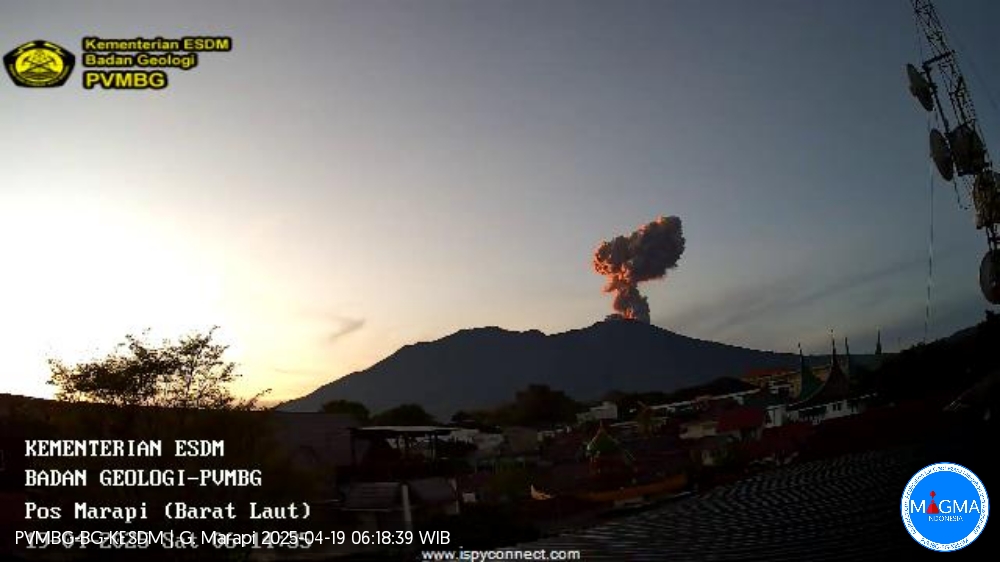
An eruption of Mount Marapi occurred on Saturday, April 19, 2025, at 06:11 WIB with an observed ash column height of ± 1000 m above the peak (± 3891 m above sea level). The ash column was observed to be gray in color with a thick intensity, oriented toward the south. This eruption was recorded on a seismograph with a maximum amplitude of 30.3 mm and a duration of 42 seconds.
VOLCANO OBSERVATORY NOTICE FOR AVIATION – VONA
Issued : April 19, 2025
Volcano : Marapi (261140)
Current Aviation Colour Code : ORANGE
Previous Aviation Colour Code : yellow
Source : Marapi Volcano Observatory
Notice Number : 2025MAR029
Volcano Location : S 0 deg 22 min 52 sec E 100 deg 28 min 23 sec
Area : West Sumatra, Indonesia
Summit Elevation : 9251 FT (2891 M)
Volcanic Activity Summary :
Eruption with volcanic ash cloud at 23h11 UTC (06h11 local).
Volcanic Cloud Height :
Best estimate of ash-cloud top is around 12451 FT (3891 M) above sea level or 3200 FT (1000 M) above summit. May be higher than what can be observed clearly. Source of height data: ground observer.
Other Volcanic Cloud Information :
Ash cloud moving to south. Volcanic ash is observed to be gray. The intensity of volcanic ash is observed to be thick.
Remarks :
Eruption recorded on seismogram with maximum amplitude 30.3 mm and maximum duration 42 second.
Source et photo : Magma Indonésie .
Guatemala , Santiaguito :
Weather conditions: Clear.
Wind: East.
Precipitation: 0.0 mm.
Activity:
Activity is reported from the Caliente dome of the Santa María-Santiaguito volcanic complex, characterized by white outgassing reaching an approximate height of 500 meters above the crater level. Weak to moderate explosions are recorded at a frequency of 1 to 2 events per hour, generating columns of gas and ash that rise up to 300 meters and are carried westward by the wind. During the night and early morning, intense incandescence was observed in the dome’s crater. Ashfall has also been reported on farms and communities near the volcano.
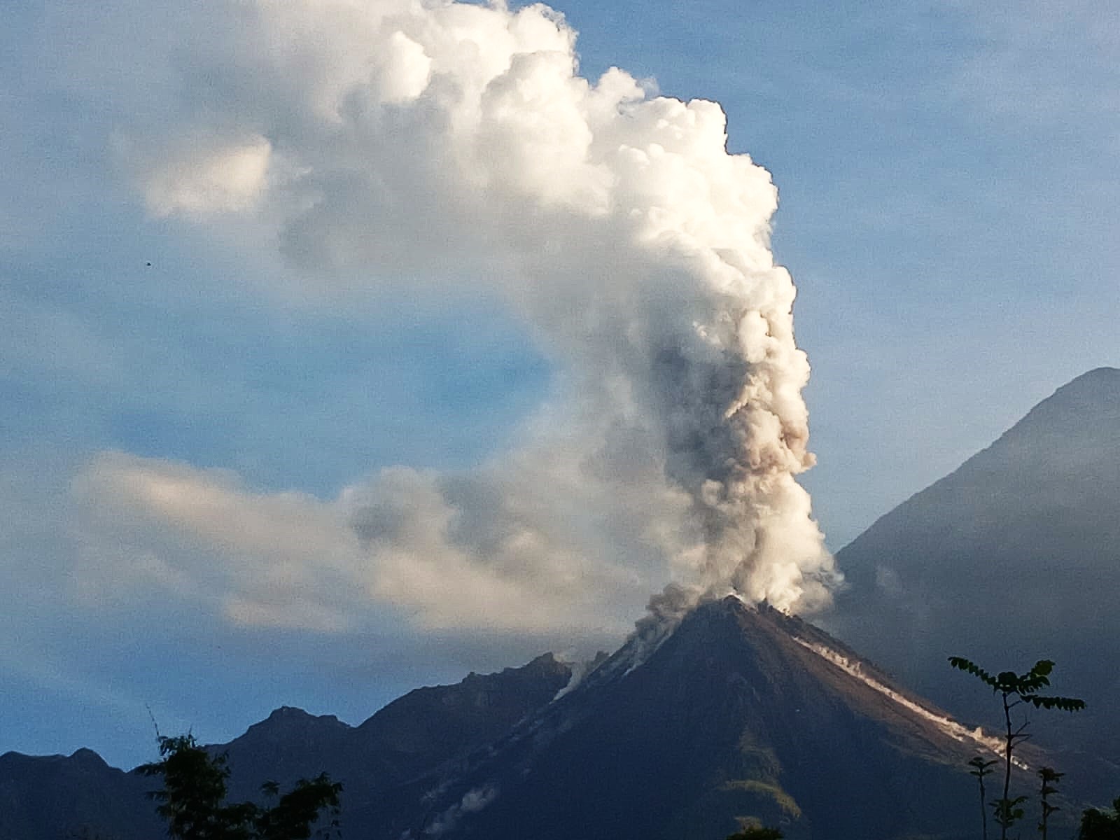
Collapses and falls of flaming volcanic material have occurred towards the southeast, south, and southwest flanks of the dome. Activity remains high, so it is possible that due to the accumulation of material, explosions, or the action of gravity, further collapses could occur, generating large-scale pyroclastic flows towards the southwest, south, and southeast.
Source : Insivumeh .
Photo : Conred ( 10/2024).
Mexico , Popocatepetl :
April 18, 11:00 AM (April 18, 5:00 PM GMT)
Activity over the past 24 hours
43 exhalations accompanied by water vapor and volcanic gases were detected. In addition, 34 minutes of exhalation sequences and 493 minutes of low-amplitude tremor were recorded, including 45 minutes of high-frequency tremor and 448 minutes of harmonic tremor.
At the time of writing, and during the early morning hours, a slight, continuous emission of water vapor and volcanic gases was observed, moving northwestward.
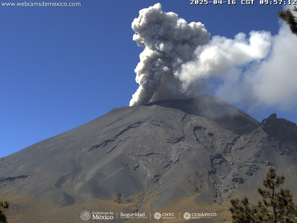
The Popocatépetl volcano fire alert is at Yellow Phase 2.
The scenarios predicted for this phase are:
A few minor to moderate explosions
Occurrence of tremors of varying amplitude
Light to moderate ashfall in surrounding towns and some more distant towns
Ejection of incandescent fragments within a 12-kilometer exclusion radius
Lahars could tumble down ravines due to ash accumulation on the slopes and their interaction with the rains expected in the coming weeks.
Possibility of pyroclastic flows not affecting populations
Source : Cenapred .