March 03 , 2019. EN. La Réunion : Piton de la Fournaise , Indonesia : Dukono , Chile : Copahue / Nevados de Chillan , Guatemala : Pacaya .

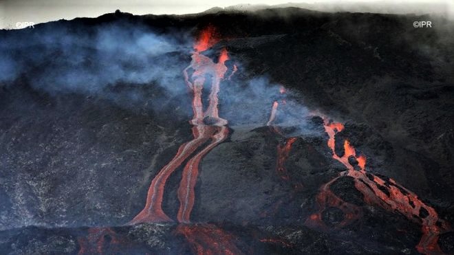
March 03 , 2019.


La Réunion , Piton de la Fournaise :

Activity Bulletin from Saturday, March 2, 2019 to 12:00 (local time).

The eruptive activity that resumed on February 19, 2019 at Piton de la Fournaise around 7:10 pm local time continues. Despite slight fluctuations in intensity and relative stability since February 25, an upward trend seems to have emerged in recent days (Figure 1)

Figure 1: Evolution of the RSAM (indicator of the volcanic tremor and the intensity of the eruption) between 09h48 (05h48 UTC) on February 18th and 11h30 (7h30 UTC) on March 2nd on the seismic station of FLR. (© OVPF / IPGP)

– Over the last 36 hours, 3 superficial volcano-tectonic earthquakes (above sea level) have been recorded.
– After a deflation of the building related to the transfer of magma that occurred on 18/02/2019, the deformations of the summit zone do not show any particular signals.
– The CO2 concentrations in the near-field soil (Cottage volcano area) remain high.

-Over the last 36 hours, surface flows estimated from satellite data, via the HOTVOLC platform (OPGC – University of Auvergne), fluctuated between <1 and 10 m3 / s. Note that low values (or zero values) are recorded when cloud cover does not allow acquisition.
– The total SO2 emissions to the atmosphere recorded by the OVPF NOVAC network (Figure 2) since the beginning of the eruption are estimated at 2.5 kton, a value in the norm of the average eruptions of Piton de la Fournaise.

Figure 2: Assessment of SO2 emissions deduced from NOVAC stations after treatment by Santiago Arellano and Bo Galle, NOVAC project managers, between 18 and 27/02/2019.

– A cartography of the lava flow dated 01/03/2018 carried out by the platform OI2 (OPGC – Clermont Auvergne University) from satellite data shows that a third flow arm was set up in the north between the 28/02/2018 and the 01/03/2018 (Figure 3). During this time the other two arms already in place do not seem to have progressed.


Figure 3: Contours of the lava flows associated with the eruptive episode of 19/02/2019 determined from satellite data by the OI2 platform (Université Clermont Auvergne), dated 20 (green), 21 (red), 22 (blue), 27 (turquoise), 28/02/2019 (pink), 01/03/2019 (white).

A new satellite acquisition from March 1st shows that this new arm split in two during the day of March 1st (Figure 4).


Figure 4: Contours of the lava flows associated with the eruptive episode of 19/02/2019 determined from satellite data by the platform OI2 (University Clermont Auvergne), dated March 1st. Evolution during the day of March 1st (morning in white and evening in purple).

Alert level: Alert 2-2

Source : OVPF

Photo : Richar Bouhet / Imaz Press 


Indonesia , Dukono :

VOLCANO OBSERVATORY NOTICE FOR AVIATION – VONA.

Issued: March 01 , 2019 
Volcano: Dukono (268010)
Current Aviation Colour Code: ORANGE
Previous Aviation Colour Code: orange
Source: Dukono Volcano Observatory
Notice Number: 2019DUK12
Volcano Location: N 01 deg 41 min 35 sec E 127 deg 53 min 38 sec
Area: North Maluku, Indonesia
Summit Elevation: 3933 FT (1229 M)

Volcanic Activity Summary:
Eruption with volcanic ash cloud at 22h55 UTC (07h55 local).

Volcanic Cloud Height:
Best estimate of ash-cloud top is around 6173 FT (1929 M) above sea level, may be higher than what can be observed clearly. Source of height data: ground observer.

Other Volcanic Cloud Information:
Ash cloud moving to South – southeast.

Remarks:
Eruption and ash emission is continuing.


Activity Level at Level II (WASPADA). the Dukono (1229 m altitude) undergoes continuous eruptions.
Since yesterday and until this morning, the volcano was clearly visible then covered with fog. It was observed that the smoke from the main crater was white / gray with a high intensity rising between 300 and 700 meters on the summit. The wind is blowing weakly to moderately in the Southeast and South.

The seismographs dated March 2, 2019 recorded:
5 distant tectonic earthquakes
Tremor continuous amplitude 0.5 to 2 mm, dominant value 0.5 mm

Recommendation: People around G. Dukono and visitors / tourists should not have activity, climb or approach the Malupang Warirang crater within 2 km.

Source : Magma Indonesia , PVMBG.

Photo : Photovolcanica.


Chile , Copahue / Nevados de Chillan :

Copahue Volcano :

Special Report on Volcanic Activity (REAV), Bio-Bio Region, Copahue Volcano, 02 March 2019, 19:00 Local Time (Continental Chile).

The National Geological and Mining Service of Chile (Sernageomin) publishes the following PRELIMINARY information, obtained through monitoring equipment of the National Volcanic Monitoring Network (NVRN), processed and analyzed at the Volcanological Observatory of the Southern Andes (OVDAS) :

Today, Saturday 02 March 2019 at 18:17 local time (21:17 UTC), the monitoring stations installed near the Copahue volcano recorded an explosive event, associated with the occurrence of an earthquake associated with a fracturing process of rocks . This event was located 11.8 Km north-east of the crater El Agrio.

The characteristics of the most important event, after its analysis, are as follows:
TIME OF ORIGIN: 18h17 (GMT -3)
LATITUDE: -37.779 ° S
LONGITUDE: -71.066 ° W
DEPTH: 7.5 KM
LOCAL MAGNITUDE: 3.5 (ML)

OBSERVATIONS:
At the time of issuing this report, no increase in seismic activity is observed. During the times when it was possible to observe the crater of the volcano, no change in surface activity was noted.
Volcanic Technical Alert Level Remains at Level: Green

Sernageomin continues online monitoring and will inform in a timely manner about any changes observed.


Nevados de Chillan Volcano :

Nuble Region, Nevados Volcano of Chillan, 01 March 2019, 23:23 local time (mainland Chile)

The National Geological and Mining Service of Chile (Sernageomin) publishes the following PRELIMINARY information, obtained from monitoring equipment of the National Volcanic Monitoring Network (RNVV), processed and analyzed at the Volcanological Observatory of the Southern Andes (OVDAS) :

Today, Friday 01 March 2019 at 23:23 local time (02:23 UTC 2 March), monitoring stations near the Nevados volcano of Chillan recorded an explosive event, associated with the occurrence of a long earthquake period (LP), which was associated with fluid dynamics within the volcanic system.

The location of the earthquake after its analysis is:
TIME OF ORIGIN: 23h23 Local time (02h23 UTC)
LATITUDE: 36.8496 ° S
LONGITUDE: 71.3891 ° W
DEPTH: 2.44 KM
REDUCED MOVEMENT: 665.36 cm2
ACOUSTIC SIGNAL: 2.89 Pa reduced to 1 KM

OBSERVATIONS:
The explosion was associated with the recording of a seismic signal having a reduced displacement value (seismic energy) of 665.36 cm2 considered high. Also, it was possible to observe an incandescence associated with emissions of gas and particulate materials at high temperatures, falling on the surroundings of the active crater. The preceding events make it possible to envisage a partial destruction of the dome located in the crater. This event is consistent with the scenario of the current level of activity present. At the time of this report, no other abnormal signals were recorded.
The level of volcanic technical alert remains at the level: ORANGE.

Sernageomin continues online monitoring and will inform in a timely manner about any changes observed.

Source : Sernageomin

Photos :  clarin.com , Ovdas.


Guatemala , Pacaya .

Type of activity: Strombolian
Morphology: Composite Stratovolcano
Geographical location: 14 ° 22’50˝ Latitude N; 90 ° 36’00˝ Longitude O.
Height: 2,552msnm.
Weather Conditions: Clear
Wind: South West at 3 km / h
Precipitation: 0.0 mm

Activity:
Presence of white degassing fumarole with an approximate height of 900 meters above the crater and a lava flow towards the north with an approximate length of 150 meters. There are avalanches in the direction of the lava flow. The seismic station records the internal tremors due to the rise of the magma and the presence of lava flows.

Source : Insivumeh

Photo : tn8.tv

03 Mars 2019. FR. La Réunion : Piton de la Fournaise , Indonesie : Dukono , Chili : Copahue / Nevados de Chillan , Guatemala : Pacaya .

03 Mars 2019.


La Réunion , Piton de la Fournaise :

Bulletin d’activité du samedi 2 mars 2019 à 12h00 (Heure locale) .

L’activité éruptive qui a repris le 19 février 2019 au Piton de la Fournaise aux alentours de 19h10 heure locale se poursuit. Malgré de légères fluctuations dans son intensité et une relative constance depuis le 25 février, une tendance à la hausse semble se dessiner depuis quelques jours (Figure 1).

Figure 1 : Evolution du RSAM (indicateur du trémor volcanique et de l’intensité de l’éruption) entre 09h48 (05h48 UTC) le 18 février et 11h30 (7h30 UTC) le 2 mars sur la station sismique de FLR. (© OVPF/IPGP)

– Sur les dernières 36 heures, 3 séismes volcano-tectoniques superficiels sommitaux (au dessus du niveau de la mer) ont été enregistrés.
– Après une déflation de l’édifice liée au transfert de magma qui s’est produit le 18/02/2019, les déformations de la zone sommitale ne montrent pas de signaux particuliers.
– Les concentrations en CO2 dans le sol en champ proche (secteur gîte du volcan) restent élevées.

– Sur les dernières 36 heures, les débits de surface estimés à partir des données satellites, via la plateforme HOTVOLC (OPGC – université d’Auvergne), fluctuaient entre <1 et 10 m3/s. A noter que les faibles valeurs (ou valeur nulle) sont enregistrées lorsque la couverture nuageuse ne permet pas d’acquisition.
– Les émissions totales de SO2 dans l’atmosphère enregistrées par le réseau NOVAC de l’OVPF (Figure 2) depuis le début de l’éruption sont estimées à 2,5 kton, valeur dans la norme de la moyenne des éruptions du Piton de la Fournaise.


Figure 2: Bilan des émissions de SO2 déduits des stations NOVAC après post traitement par Santiago Arellano et Bo Galle, responsables du projet NOVAC, entre le 18 et le 27/02/2019.

– Une cartographie de la coulée de lave en date du 01/03/2018 réalisée par la plateforme OI2 (OPGC – Université Clermont Auvergne) à partir de données satellites montre qu’un troisième bras de coulée s’est mis en place au nord entre le 28/02/2018 et le 01/03/2018 (Figure 3). Pendant ce laps de temps les deux autres bras déjà en place ne semblent pas avoir progressé.


Figure 3 : Contours des coulées de lave associées à l’épisode éruptif du 19/02/2019 déterminés à partir de données satellites par la plateforme OI2 (Université Clermont Auvergne), en date du 20 (vert), 21 (rouge), 22 (bleu), 27 (turquoise), 28/02/2019 (rose), 01/03/2019 (blanc).

Une nouvelle acquisition satellite datant du 1er mars soir montre que ce nouveau bras s’est scindé en deux lors de la journée du 1er mars (Figure 4).


Figure 4 : Contours des coulées de lave associées à l’épisode éruptif du 19/02/2019 déterminés à partir de données satellites par la plateforme OI2 (Université Clermont Auvergne), en date du 1er mars. Evolution au cours de la journée du 1er mars (matin en blanc et soir en violet).

Niveau d’alerte : Alerte 2-2

Source : OVPF

Photo : Richar Bouhet / Imaz Press 


Indonésie , Dukono :

AVIS D’OBSERVATION DU VOLCAN POUR L’AVIATION – VONA.

Émis: 01 Mars  2019 
Volcan: Dukono (268010)
Code couleur de l’aviation actuel : ORANGE
Code couleur d’aviation précédent: orange
Source: Observatoire du volcan Dukono
Numéro de l’avis: 2019DUK12
Emplacement du volcan: N 01 ° C 41 min 35 sec E 127 ° C 53 min 38 s
Région: Maluku Nord, Indonésie
Élévation du sommet: 3933 FT (1229 M)

Résumé de l’activité volcanique:
Eruption avec nuage de cendres volcaniques à 22h55 UTC (07h55 locale).

Hauteur du nuage volcanique:
La meilleure estimation du sommet des nuages de cendres est d’environ 1929 M (6173 FT) au-dessus du niveau de la mer, ce qui peut être plus élevé que ce qui peut être observé clairement. Source des données de hauteur: observateur au sol.

Autres informations sur les nuages volcaniques:
Nuage de cendres se déplaçant vers le Sud-Sud-Est.

Remarques:
L’éruption et les émissions de cendres se poursuivent.


Niveau d’activité de niveau II (WASPADA). le Dukono (1229 m d’altitude) subit des éruptions continues.
Depuis hier et jusqu’à ce matin, le volcan était clairement visible puis recouverts de brouillard. On a observé que la fumée issue du cratère principal était de couleur blanche / grise avec une intensité élevée s’élevant entre 300 et 700 mètres sur le sommet. Le vent souffle faiblement à modérément au Sud-Est et au Sud.
Les sismographes en date du 2 mars 2019 ont enregistré:
5 tremblements de terre tectoniques lointains
Tremor continu d’amplitude 0,5 à 2 mm, valeur dominante 0,5 mm
Recommandation: Les gens autour du G. Dukono et les visiteurs / touristes ne doivent pas avoir d’activité, escalader ni s’approcher du cratère Malupang Warirang dans un rayon de 2 km.

Source : Magma Indonesia , PVMBG.

Photo : Photovolcanica.


Chili , Copahue / Nevados de Chillan :

Volcan Copahue :

Rapport spécial sur l’activité volcanique (REAV) , Région del Bio-Bio , Volcan Copahue , 02 Mars 2019, 19h00 Heure locale (Chili continental).

Le Service national de géologie et des mines du Chili (Sernageomin) publie les informations PRELIMINAIRES suivantes, obtenues grâce aux équipements de surveillance du Réseau national de surveillance volcanique (RNVV), traitées et analysées à l’Observatoire volcanologique des Andes du Sud (OVDAS) :

Aujourd’hui , Samedi 02 Mars 2019 à 18h17 Heure locale (21h17 UTC   ), les stations de surveillance installées à proximité du volcan Copahue ont enregistré un évènement explosif , associé à l’occurrence d’un séisme  associés à un processus de fracturation de roches. Cet évènement a été localisé à 11,8 Km au Nord-Est du cratère El Agrio.

Les caractéristiques de l’évènement le plus important , après son analyse, sont les suivantes:
TEMPS D’ ORIGINE : 18h17 (GMT -3)
LATITUDE: -37.779 ° S
LONGITUDE : -71.066 °O
PROFONDEUR: 7,5 KM
MAGNITUDE LOCALE : 3,5 ( ML)

OBSERVATIONS:
Au moment de l’émission de ce rapport , on n’observe pas d’augmentation de l’activité  sismique . Pendant les moments ou il a été possible d’observer le cratère du volcan , il n’a pas été noté de changement de l’activité superficielle .

Le niveau d’alerte technique volcanique reste au niveau : Vert
Le Sernageomin poursuit la surveillance en ligne et informera de manière opportune sur les changements éventuels observés.

Volcan Nevados de Chillan :

Région De Nuble , Volcan Nevados de Chillan , 01 Mars 2019, 23h23  Heure locale (Chili continental)

Le Service national de géologie et des mines du Chili (Sernageomin) publie les informations PRELIMINAIRES suivantes, obtenues grâce au matériel de surveillance du Réseau national de surveillance volcanique (RNVV), traitées et analysées à l’Observatoire volcanologique des Andes du Sud (OVDAS):

Aujourd’hui , Vendredi 01 Mars 2019 à 23h23 Heure locale (02h23 UTC le 2 Mars ), les stations de surveillance installées à proximité du volcan Nevados de Chillan ont enregistré un évènement explosif , associé à l’occurrence d’un séisme de type longue période (LP ), lequel était associé à la dynamique des fluides à l’intérieur du système volcanique .

La localisation du séisme après son analyse est :
TEMPS D’ ORIGINE : 23h23 Heure locale (02h23 UTC)
LATITUDE: 36,8496° S
LONGITUDE : 71,3891° O
PROFONDEUR: 2,44 KM
DEPLACEMENT REDUIT : 665,36 cm2
SIGNAL ACOUSTIQUE : 2,89 Pa réduits à 1 KM

OBSERVATIONS:
L’ explosion a été associée avec l’enregistrement d’un signal sismique ayant une valeur de déplacement réduit ( énergie sismique) de 665,36 cm2 considérée comme haute . Egalement , il a été possible d’observer une incandescence associée aux émissions de gaz et de matériaux particulaires à hautes températures , retombant sur les alentours du cratère actif . Les évènements précédents permettent d’envisager une destruction partielle du dôme localisé dans le cratère. Cet évènement est conforme au scenario de l’actuel niveau d’activité présent . Au moment de ce rapport , il n’a pas été enregistré d’autres signaux anormaux.
Le niveau d’alerte technique volcanique reste au niveau : ORANGE .

Le Sernageomin poursuit la surveillance en ligne et informera de manière opportune sur les changements éventuels observés.

Source : Sernageomin

Photos :  clarin.com , Ovdas.


Guatemala , Pacaya .

Type d’activité: Strombolienne
Morphologie: Stratovolcan composite
Localisation géographique: 14 ° 22’50˝ Latitude N; 90 ° 36’00˝ Longitude O.
Hauteur: 2,552msnm.
Conditions météorologiques: Claires
Vent: Sud à 3 km / h
Précipitations: 0.0 mm

Activité:
Présence de fumerole blanche de dégazage d’une hauteur approximative de 900 mètres au-dessus du cratère et d’une coulée de lave en direction du Nord avec une longueur approximative de 150 mètres. On note des avalanches dans le sens de la coulée de lave. La station sismique enregistre les tremors internes dus à la remontée du magma et à la présence de coulées de lave.

Source : Insivumeh

Photo : tn8.tv