April 04 , 2018. EN. Piton de la Fournaise , Chiles / Cerro Negro , Ticsani , Ambae .

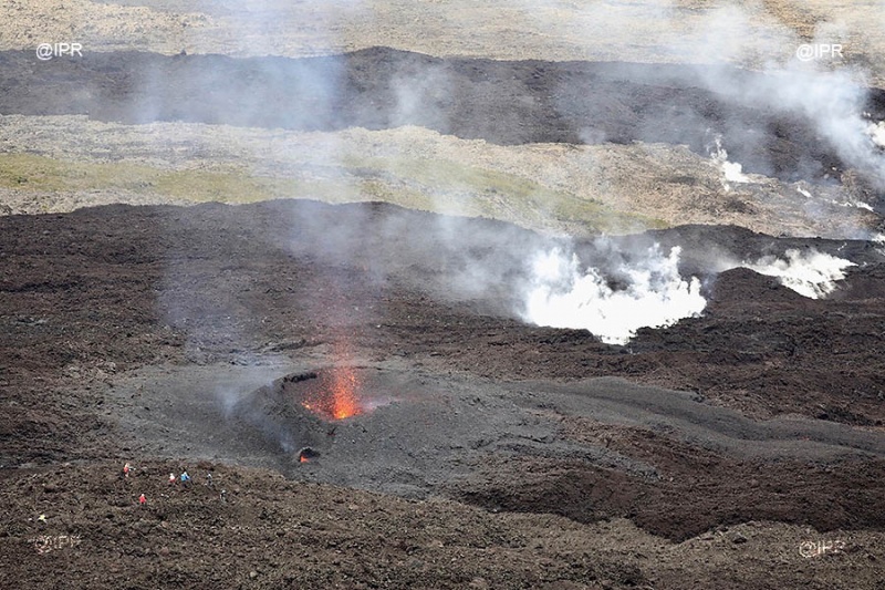
April 04 , 2018.


Piton de la Fournaise , La Réunion :

Volcano – Flight over the first eruption of the year. (Update 03/04, 16h00).

The volcano erupted on Tuesday, April 3, 2018 at 11 o’clock. « According to the information provided by the Volcanological Observatory of Piton de la Fournaise, the eruption occurs on the North flank near the Nez Coupé de Sainte-Rose. » No visual confirmation of an eruption onset. ‘could be done for now’ indicates the prefecture that triggered triggered the 2-2 alert of the « Orsec * Volcano » plan: eruption in progress. Despite bad weather, Imaz Press Réunion was able to fly over the eruption to offer you breathtaking images (Photo rb / www.ipreunion.com).

Since 6 am on Tuesday the volcano had been placed on alert 1 meaning that an eruption is likely or imminent. « The volcanological observatory of Piton de la Fournaise records since 5h50, Tuesday an increase in the number of earthquakes of increasing intensity and persistent deformations at the top of the volcano, » said the prefecture in its statement.

Just before 11:00, the apparatus of the volcanological observatory recorded an eruptive tremor towards the rampart at the level of the Nez Coupé de Sainte-Rose. A strong seismic signal indicating that the lava is close to the surface recorded by the observatory
Public access to the  Enclos Fouqué, whether from the Pas de Bellecombe Trail or any other trail, as well as placing aircraft in the volcano area is prohibited until further notice.

Activity Bulletin from Tuesday, April 3, 2018 at 5:30 pm (local time)
The eruption started on April 3, 2018 at 10:40 am continues. The volcanic tremor (indicator of surface eruptive intensity) continues to intensify, especially on the seismological stations located north of the volcano (Figure 1).


Figure 1: Evolution of the RSAM (indicator of the volcanic tremor and the intensity of the eruption) between 3:00 (23:00 UTC 02) and 15:30 (11:30 UTC) on 3 April 2018 on the NSR seismic station, located on the flank north of the volcano (© OVPF / IPGP)

Following a reconnaissance made by a team of the OVPF at the ramparts of the Enclos, the eruptive activity could be confirmed. It is located on the north flank of the volcano at the top of the broken slopes (Figure 2).

Figure 2: Photograph of the eruptive site in the late morning (11h50) (© OVPF / IPGP)

A helicopter overflight of the eruptive site by a second team of the OVPF in the middle of the afternoon allowed to locate more precisely the eruption. A long crack about 1km long opened in 7 distinct segments, two with emissions of lava fountains. The last active segment is just below the rampart below the Nez Coupé de Sainte Rose (Figure 3).
At 16:00 local time, many landslides were recorded by the OVPF network in the rampart at the Nez Coupé de Sainte Rose area, and many fumaroles were observed on site at this level.
Given these observations and the location of the downstream point at the foot of the rampart, further propagation (inside or outside the Enclos) of new eruptive fissures in the next few hours remains possible.


Figure 3: Axis according to which opened the eruptive crack. (© OVPF / IPGP)

Activity Bulletin from Wednesday, April 4, 2018 to 08:30 (local time)
Following a very sharp fall in the volcanic tremor (indicator of surface eruptive intensity) at 1 o’clock (local time, 21h UTC), the surface eruptive activity started on April 3, 2018 at 10:40 am local time stopped. day, April 4, 2018 at 4:00 am (local time, 00h GMT), after a gas piston phase.


Figure 1: Evolution of RSAM (Indicator of Volcanic Tremor and Intensity of Eruption) between April 3 at 3:00 pm (23:00 UTC) and April 4 at 6:00 (2:00 UTC) 2018 at the NSR seismic station, located on the North flank of the volcano. (© OVPF / IPGP)

No assumptions are made about the evolution of the future situation (permanent shutdown, resumption of activity on the same site, resumption of activity further downstream whether it is inside or outside Enclos Fouqué), taking into account the following observables:
• Many earthquakes under the Plaine des Osmondes sector.
• Many landslides in the rampart of the Nez Coupé de Sainte Rose.
• The location near the rampart of the eruptive fissure (Figure 2).


Figure 2: Location of eruptive fissures and lava flows emitted during the eruptive phase of April 3, 2018. (© OVPF / IPGP)


Figure 2b: Zoom on the location of eruptive fissures and flows from the eruptive phase of 03 April 2018. (© OVPF / IPGP)


Source : Imaz Press Réunion , OVPF.

Photos : Imaz Press Réunion . 


Chiles / Cerro Negro , Colombia :

Subject: Activity bulletin of Chiles and Cerro Negro volcanoes

The level of activity of volcanoes is maintained at the level:
YELLOW LEVEL ■ (III): CHANGES IN THE CONDUCT OF VOLCANIC ACTIVITY

Following the activity of VOLCANS CHILES and CERRO NEGRO, the COLOMBIAN GEOLOGICAL SERVICE (SGC) reports that:

The increase in seismic activity recorded on March 21 and reported the previous week continues, accumulating to date about 17,000 earthquakes, with a daily maximum frequency of 1,740 events on April 1. The nominal seismic activity is mainly associated with the fracture of solid materials, preferentially localized to the south and south-east of the cone of the Chiles volcano, with distances of up to 11 km and depths of less than 10 km under the summit. (4700 m). The maximum local amplitude reached was M4.0 on the Richter scale. It is highlighted the presence of earthquakes that have been reported as felt by the inhabitants of the municipalities of Cumbal, Túquerres, Pupiales and Ipiales.

Although it is true, as mentioned above, that the predominant activity corresponds to fracture processes, it should be noted that there have been earthquakes that suggest a movement of fluid inside the volcano at a certain depth, without, for the moment, observed volcanic manifestations on the surface.

The Colombian Geological Survey and the Institute of Geophysics of the National Polytechnic School of Ecuador closely monitor the evolution of this seismic and volcanic activity and report without delay on the changes detected.

Source : SGC


Ticsani , Peru :

The Ticsani volcano is a stratovolcano whose main characteristic is to have presented very large avalanches. A possible eruption of this volcano is a potential threat to nearby cities such as Calacoa (8 km from the recent crater), Carumas (11 km) and others. Here is the summary of the activity between March 16 and March 31, 2018.

Analysis of the period:
The Ticsani volcano has low levels of activity. Earthquakes of typeVT, related to rock fractures, have an average rate of 31 events per day. On March 17, a group (swarm) of distal earthquakes was observed. This seismic swarm was located 11 km southeast of the Ticsani volcano, as well as scattered seismicity in the region. Earthquakes had amplitudes between 1.6 ML and 3.6 ML (local magnitude).

SO2 levels maintain low values. Similarly, no thermal anomaly has been detected.

Recommendation:
Implement prevention and mitigation measures in the face of increased activity.
Always stay informed about the activity of the Ticsani volcano through the reports published by the OVS-IGP. The next report will be published on April 16th.

Source : IGP


Ambae , Vanuatu.

VANUATU VOLCANO ALERT BULLETIN N°3 – AMBAE ACTIVITY
Wednesday April 4th 2018

AMBAE VOLCANO
15°24’0”S 167°50’0”E
Summit 4908ft (1496m)
Current Vanuatu Volcano Alert Level: Level 3

Ambae volcano is continuing in the minor eruption state; Its Volcanic Alert Level remains at Level 3 .

The volcanic eruption at Ambae confined inside the Lake Voui is stable at Alert Level 3. The volcanic activity is likely to remain at the minor eruptive activity or decrease to a major level of unrest at any time. The restricted area of risk is limited to the area of 3 km from the active vent and areas located in the Yellow Zone (See Map below).

Observations of March and early April 2018 confirm that the Ambae eruption style has changed, the volcano emitted more and sustained volcanic ash or/and gases. The presence of accumulated ash that is falling around the volcanic area could change the behaviour of streams and creeks when it rains. The creeks and streams could produce floods and carry a lot more debris (sands, gravel and boulders). The flow path of streams and creeks could change due to the flood debris. Landslide may occur at some areas during heavy rain fall.

These observations and the analysis of seismic data confirm that the volcano activity is in the level of minor eruption state. The volcano activity consist of ongoing emission of ashes, gases and volcanic bombs.

The possibility that the Ambae volcano activity escalate to the level of moderate eruption is low .

Ambae volcano is a very large volcano and is frequently active. In the recorded history, there have been many eruptions, every 10-50 years over the past 150 years. All have been from the summit craters, except one recorded in 1670’s when a lava flow occurred in the Ndui Ndui area. The current eruption is focused in the summit crater and there are no indications of activity elsewhere on Ambae Island.

Advise to all tourism agencies, local authorities, people of Ambae and the general public not to access the Danger Zone which is about 3 km radius from the eruptive vents. Volcanic gases, ashes and projectiles are expected in this area . Villages in the Yellow color may expect occurrence of dangerous flow (See map below). Villages from Ambae island may experience impacts of volcanic gases, ashes and acid rain especially those exposed to prevailing trade winds direction .

The Vanuatu Meteorological and Geohazard Department will continue to monitor this volcanic activity closely. More information will be provided if available.

Source : Geohazard