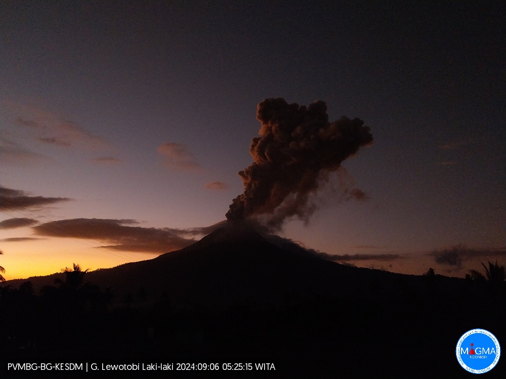
18 Mai 2023. FR. Alaska : Semisopochnoi , Indonésie : Semeru , Japon : Sakurajima , Hawaii : Kilauea , Colombie : Chiles / Cerro Negro .

18 Mai 2023.


Alaska , Semisopochnoi :

Avis d’activité volcanique AVO/USGS

Niveau d’alerte volcanique actuel : AVIS
Niveau d’alerte volcanique précédent : SURVEILLANCE
Code couleur actuel de l’aviation : JAUNE
Code couleur aviation précédent : ORANGE

Émis : mercredi 17 mai 2023, 13 h 25 AKDT
Source : Observatoire du volcan d’Alaska
Numéro d’avis : 2023/A694
Emplacement : N 51° 55 min E 179° 35 min
Altitude: 2625 pieds (800 m)
Zone : Aléoutiennes

Résumé de l’activité volcanique :
Le niveau d’activité éruptive sur le Semisopochnoi a diminué au cours de la semaine dernière. La dernière preuve d’émissions de cendres du volcan a été observée le 5 mai et consistait en un léger saupoudrage de cendres sur le flanc Nord-Ouest du mont Young. Le code couleur de l’aviation et le niveau d’alerte volcan sont abaissés à JAUNE/AVIS.

De petites éruptions produisant des dépôts de cendres mineurs à proximité du cratère Nord actif du mont Young et des nuages ​​de cendres généralement à moins de 10 000 pieds (3 km) au-dessus du niveau de la mer ont caractérisé l’activité récente et davantage d’événements producteurs de cendres pourraient se reproduire sans avertissement.

Le Semisopochnoi est surveillé par un réseau de capteurs sismiques et infrasonores local, des caméras Web locales, des capteurs régionaux de foudre et d’infrason et des données satellitaires.

Remarques:
Le volcan éloigné Semisopochnoi occupe la plus grande et jeune île volcanique des Aléoutiennes occidentales. L’île inhabitée fait partie de l’Alaska Maritime National Wildlife Refuge. Il est situé à 65 km (40 mi) au Nord-Est de l’île d’Amchitka et à 200 km (130 mi) à l’Ouest d’Adak, en Alaska. Le volcan Semisopochnoi est dominé par une caldeira de 8 km (5 miles) de diamètre qui contient un petit lac et plusieurs cônes et cratères post-caldeira. L’âge de la caldeira n’est pas connu avec certitude mais est probablement du début de l’Holocène. Le cône Nord du mont Young, dans la partie Sud-Ouest de la caldeira, est le site de l’éruption actuelle, qui a commencé en 2018. La dernière éruption connue avant 2018 remonte à 1987 depuis Sugarloaf Peak sur la côte Sud de l’île.

Source : USGS

Photo : Loewen, Matt / Alaska Volcano Observatory / U.S. Geological Survey.


Indonésie , Semeru :

AVIS D’OBSERVATION DU VOLCAN POUR L’AVIATION – VONA

Publié : 18 mai 2023 .
Volcan : Semeru (263300)
Code Couleur Aviation Actuel : ORANGE
Code Couleur Aviation précédent : orange
Source : Observatoire du volcan Semeru
Numéro d’avis : 2023SMR184
Emplacement du volcan : S 08 deg 06 min 29 sec E 112 deg 55 min 12 sec
Région : Java oriental, Indonésie
Altitude du sommet : 11763 FT (3676 M)

Résumé de l’activité volcanique :
Eruption avec nuage de cendres volcaniques à 01h22 UTC (08h22 locale).

Hauteur des nuages volcaniques :
La meilleure estimation du sommet du nuage de cendres est d’environ 14323 FT (4476 M) au-dessus du niveau de la mer ou 2560 FT (800 M) au-dessus du sommet. Peut être plus élevé que ce qui peut être observé clairement. Source des données de hauteur : observateur au sol.

Autres informations sur les nuages volcaniques :
Nuage de cendres se déplaçant vers le Sud. On observe que les cendres volcaniques sont blanches à grises. On observe que l’intensité des cendres volcaniques est épaisse.

Remarques :
Eruption enregistrée sur sismogramme avec une amplitude maximale de 22 mm et une durée maximale de 79 secondes.

Source : Magma Indonésie.

Photo : Andi volcanist


Japon , Sakurajima :

Le JMA a signalé une activité continue à la fois dans le cratère Minamidake et dans le cratère Showa (sur le volcan Sakurajima  ) du 8 au 15 mai. L’incandescence du cratère a été observée la nuit dans le cratère Minamidake. Le 8 mai, les émissions de dioxyde de soufre étaient extrêmement élevées à 3 900 tonnes par jour. À 13 h 15 le 9 mai, une explosion dans le cratère Minamidake a généré un panache de cendres qui s’est élevé à 1,2 km au-dessus du bord du cratère et a dérivé vers le Sud-Ouest, et a éjecté des blocs à 1,1 km de l’évent. Les événements éruptifs à 15h27, 17h24 et 18h17 le 11 mai ont produit des panaches de cendres qui se sont élevés jusqu’à 1,3 km et ont dérivé vers le Nord-Ouest et l’Ouest.

Dans le cratère Showa , les événements éruptifs enregistrés à 10h09, 13h03 et 14h01 le 8 mai, à 05h50, 07h26, 22h04 et 23h21 le 11 mai, à 18h31 le 12 mai et à 08h59 le 14 mai ont produit des panaches de cendres qui se sont élevés jusqu’à 1,7 km au-dessus du bord du cratère et ont dérivé dans plusieurs directions. Les émissions de dioxyde de soufre étaient quelque peu élevées le 12 mai, avec une moyenne de 1 800 tonnes par jour. Le niveau d’alerte est resté à 3 (sur une échelle de 5 niveaux) et les résidents ont été avertis de rester à 2 km des deux cratères.

Sources : Agence météorologique japonaise (JMA) , GVP

Photo : Deniss García Mendoza


Hawaii , Kilauea :

Mercredi 17 mai 2023, 9 h 06 HST (mercredi 17 mai 2023, 19 h 06 UTC)

19°25’16 » N 155°17’13 » O,
Altitude du sommet : 4091 pieds (1247 m)
Niveau d’alerte volcanique actuel : AVIS
Code couleur actuel de l’aviation : JAUNE

Résumé de l’activité :
Le volcan Kīlauea n’est pas en éruption et aucune lave active n’a été observée depuis le 7 mars 2023. La sismicité du sommet reste élevée. Les inclinomètres sont revenus à une inflation progressive. Aucun changement significatif n’a été observé le long de l’une ou l’autre des zones de faille du volcan au cours de la dernière journée.

Observations du cratère Halema’uma’u :
Aucune lave active n’a été observée au cours de la dernière journée.

Observations du sommet :
Les inclinomètres du sommet montrent une inflation progressive au cours de la dernière journée. Dans l’ensemble, l’inflation au sommet du Kīlauea est toujours plus élevée que les conditions précédant l’éruption du sommet du 5 janvier 2023. De petites rafales de tremblements de terre se poursuivent de manière irrégulière sous Halemaʻumaʻu, le cratère Keanakākoʻi et la marge Sud de Kaluapele (Kīlauea caldera) depuis le 16 avril. Dans l’ensemble, les taux de tremblements de terre au sommet restent élevés et d’autres rafales de tremblements de terre sont possibles. Le taux d’émission le plus récent de dioxyde de soufre (SO2) d’environ 151 tonnes par jour a été mesuré le 16 mai 2023.

Observations de la zone de rift :
Aucune activité inhabituelle n’a été notée le long de la zone de rift Est ou de la zone de rift Sud-Ouest ; des taux constants de déformation du sol et de sismicité se poursuivent le long des deux. Les mesures des stations de surveillance continue des gaz dans la zone du Rift du sud-Est – le site de l’activité éruptive de 1983 à 2018 – restent inférieures aux limites de détection du SO2.

Source : HVO

Photo : USGS / M. Patrick.


Colombie , Chiles / Cerro Negro :

Bulletin d’activité hebdomadaire du complexe volcanique de Chiles et Cerro Negro (CVCCN)

Concernant le suivi de l’activité des VOLCANS CHILES ET CERRO NEGRO, le MINISTÈRE DES MINES ET DE L’ÉNERGIE à travers le SERVICE GÉOLOGIQUE COLOMBIEN (SGC) informe que :

Par rapport à la semaine précédente, l’évaluation de l’activité volcanique dans la période comprise entre le 9 et le 15 mai 2023, a montré une augmentation, à la fois de l’occurrence et de l’énergie sismique libérée, sans atteindre les niveaux observés pour les mois de mars ou avril. Les tremblements de terre associés aux fractures rocheuses continuent de prédominer à l’intérieur du volcan et des fluctuations sont enregistrées dans les événements liés à la dynamique des fluides à l’intérieur du système volcanique.
La plupart des tremblements de terre de fracture continuent d’être situés à proximité et au Sud du volcan Chiles, à des distances allant jusqu’à 4 km, avec des profondeurs inférieures à 10 km, par rapport à son sommet.


Dans la période évaluée, le séisme de magnitude 4,1 du 12 mai à 01h06 est mis en évidence, rapporté comme ressenti par les habitants des régions proches du CVCCN. De plus, cette semaine
huit événements de magnitude supérieure ou égale à 2 se sont produits, bien qu’aucun d’entre eux n’ait été signalé comme ressenti par les habitants de la zone.
Les processus de déformation enregistrés se poursuivent, à la fois par des capteurs installés sur les volcans et par des capteurs satellites à distance.
Il est important de rappeler qu’en raison du comportement fluctuant du CVCCN, la possibilité de séismes de haute énergie pouvant être ressentis par les habitants de la zone d’influence n’est pas exclue.

Le niveau d’activité des volcans reste au NIVEAU JAUNE ■ (III) : MODIFICATIONS DU COMPORTEMENT DE L’ACTIVITÉ VOLCANIQUE

Source : SGC

Photo : IGEPN


May 12, 2023. EN. Indonesia : Anak Krakatau , Kamchatka : Sheveluch , Italy : Vulcano , Chile : Copahue , Colombia : Chiles / Cerro Negro.

May 12 , 2023.


Indonesia , Anak Krakatau :

An eruption of Mount Anak Krakatau occurred on Friday May 12, 2023 at 09:20 WIB with the height of the ash column observed at ± 2500 m above the summit (± 2657 m above sea level). The ash column was observed to be gray with a thick intensity, oriented to the southwest. This eruption was recorded on a seismograph with a maximum amplitude of 70 mm and a duration of 42 seconds.

VOLCANO OBSERVATORY NOTICE FOR AVIATION – VONA

Issued : May 12 , 2023
Volcano : Anak Krakatau (262000)
Current Aviation Colour Code : ORANGE
Previous Aviation Colour Code : orange
Source : Anak Krakatau Volcano Observatory
Notice Number : 2023KRA049
Volcano Location : S 06 deg 06 min 07 sec E 105 deg 25 min 23 sec
Area : Lampung, Indonesia
Summit Elevation : 502 FT (157 M)

Volcanic Activity Summary :
Eruption with volcanic ash cloud at 02h20 UTC (09h20 local).

Volcanic Cloud Height :
Best estimate of ash-cloud top is around 8502 FT (2657 M) above sea level or 8000 FT (2500 M) above summit. May be higher than what can be observed clearly. Source of height data: ground observer.

Other Volcanic Cloud Information :
Ash cloud moving to southwest. Volcanic ash is observed to be gray. The intensity of volcanic ash is observed to be thick.

Remarks :
Eruption recorded on seismogram with maximum amplitude 70 mm and maximum duration 42 second

Source : Magma Indonésie.


Kamchatka , Sheveluch :

56.64 N, 161.32 E;
Elevation 3283 m (10768 ft),
the dome elevation ~2500 m (8200 ft)
Aviation Colour Code is ORANGE

An extrusive eruption of the volcano continues. A danger of ash explosions up to 10 km (32,800 ft) a.s.l. is remains. Ongoing activity could affect international and low-flying aircraft.

The growth of the lava dome in the explosive crater, formed during the paroxysmal eruption of the Sheveluch volcano on April 10-13, 2023, continues.

The extrusive volcanic eruption continues: lava blocks are squeezed out in the explosive crater of the Young Sheveluch, it is accompanied by powerful gas-steam activity, an incandescence of the lava dome, and sometimes hot avalanches and explosions. In the area of the Karan dome, powerful gas-steam activity is also observed, probably associated with the growth of a new lava dome. According to KVERT satellite data, on 08-09 May, the plume of resuspended ash, lifted by the wind from the field of pyroclastic flow deposits formed on the southeastern slope of the volcano during the April 10-13, 2023 eruption, extended 60 km west of the volcano; thermal anomalies were observed in the area of the active volcano crater and Karan dome all week.

Source : Kvert

Photo : Yu. Demyanchuk, IVS FEB RAS, KVERT

Italy , Vulcano :

WEEKLY BULLETIN, from May 01, 2023 to May 07, 2023. (issue date 09 May 2023)

ACTIVITY STATUS SUMMARY
In the light of the monitoring data, it is highlighted:
1) Temperature of the crater fumaroles: The temperature signal recorded on the edge of the crater is strongly disturbed by the intense rainfall events but always remains at high values.
2) CO2 fluxes in the crater area: CO2 fluxes in the summit area show a downward trend with values around 6000 g/m2/day
3) SO2 flux in the crater area: decreasing towards an average level
4) Geochemistry of fumarolic gases: There are no updates.
5) CO2 fluxes at the base of the La Fossa cone and in the Vulcano Porto area: The CO2 fluxes recorded at the sites of Rimessa, C. Sicilia show stable values, always above background levels. The P4max site displays medium-low values, while values close to the background noise are recorded on the Faraglione site.
6) Geochemistry of thermal aquifers: stable but still high temperature values are recorded in the Camping Sicilia well and do not show variations in conductivity values; in the Bambara well, no significant change in the monitored parameters was observed.
7) Local seismicity: Very low values of the event occurrence rate.

8) Regional seismicity: Low fracturing activity, only one earthquake was recorded, with a magnitude of 1.5.
9) Deformations – GNSS: The network of permanent GNSS stations has not recorded any significant variations
10) Deformations – Inclinometry: The inclinometric network did not record any significant variations.
11) Gravimetry: No significant change was recorded.
12) Other Comments: Mobile GNSS.
The time series acquired so far by the mobile GNSS network do not show significant variations around the Porto di Levante area.

CO2 FLOW IN THE CRATER AREA
Data from the VSCS station updated to May 03, 2023 show decreasing average values with values around 6000 g/m2/day.
The monthly average for April was 5206 g/m2/day, down from the previous month but still anomalous compared to average background values assessed over the past decade of observations and monitoring. . In the following months we will verify this drop to rule out that it was not caused by the unfavorable weather conditions recorded in April.

Source : INGV.

Photo : Emanuel Raffaele Photography


Chile , Copahue :

Seismology
The seismological activity of the period was characterized by the recording of:
27 VT-type seismic events, associated with rock fracturing (Volcano-Tectonics). The most energetic earthquake presented a local magnitude value (ML) equal to 1.5, located 8.6 km to the East-North-East and with a depth of 5.2 km from the crater .
2 LP-type seismic events, associated with fluid dynamics within the volcanic system (Long Period). The size of the largest earthquake assessed from the Reduced Displacement (DR) parameter was equal to 2 cm2.
1 HB-type seismic event, associated with both rock fracture and fluid dynamics within the volcanic system (Hybrid). This earthquake presented a reduced displacement value (DR) of 13 cm2 and a local magnitude value (ML) equal to 1.1, located 4.4 km to the West-South-West and with a depth 15.5 km from the crater.

Fluid Geochemistry
The sulfur dioxide (SO2) emission data obtained by the optical differential absorption spectroscopy (DOAS) equipment, corresponding to the Mellizas station, installed 6 km east-northeast of the active crater, have presented an average value of 376 ± 52 t/d, with a maximum value of 1173/d on April 18. According to the activity of the volcano, these values remain at levels considered low.
No anomalies in sulfur dioxide (SO2) emissions into the atmosphere have been reported in the area near the volcano, according to data published by the Tropospheric Monitoring Instrument (TROPOMI) and the Ozone Monitoring Instrument.

Satellite thermal anomalies
During the period, no thermal alert was recorded in the area associated with the volcanic edifice, according to data processed by Middle Infrared Observation of Volcanic Activity MIROVA, and by analytical processing of Sentinel 2-L2A satellite images, in combination of false color bands.

Geodesy
According to data provided by 4 GNSS stations in the volcanic area, no significant variation associated with volcanic deformation is observed during the evaluated period. The vertical displacement rates are almost nil, while the horizontal displacement rates remain at values below 0.5 cm/month.

Surveillance cameras
The images provided by the fixed camera, installed near the volcano, recorded regular degassing during the evaluated period, with a maximum column height of 80 meters on April 19.
Activity remained at levels considered low, suggesting stability of the volcanic system. The volcanic technical alert is maintained at:

GREEN TECHNICAL ALERT: Active volcano with stable behavior – There is no immediate risk

Source : Sernageomin

Photo : Carpediem1971


Colombia , Chiles / Cerro Negro :

Weekly activity bulletin of the Chiles and Cerro Negro Volcanic Complex (CVCCN)

Regarding the monitoring of the activity of the VOLCANOES CHILES AND CERRO NEGRO, the MINISTRY OF MINES AND ENERGY through the COLOMBIAN GEOLOGICAL SERVICE (SGC) informs that:

In the period between May 2 and May 8, 2023, and compared to previous weeks, a decrease in occurrence and released seismic energy was recorded, although high seismicity levels remain. Earthquakes associated with rock fractures continue to predominate inside the volcano, with fluctuations in events related to fluid dynamics within the volcanic system.

The vast majority of fracture earthquakes continued to be located in the immediate vicinity and south of the Chiles volcano, at distances of up to 4 km, with depths less than 7 km, from its summit. During the period evaluated, there were three events of magnitude greater than or equal to 2, one of which was reported as felt by inhabitants residing in the areas close to the CVCCN (sectors of the municipalities of Cumbal, Guachucal and Túquerres), corresponding to the event recorded on May 5 at 01:05, with a magnitude of 3.8.
Deformation processes recorded by sensors installed on volcanoes and by satellite remote sensing also continue.
It is important to remember that due to the fluctuating behavior of the CVCCN, the possibility of high-energy earthquakes that can be felt by the inhabitants of the area of influence is not excluded.

The activity level of the volcanoes remains at:
YELLOW LEVEL ■ (III): CHANGES IN THE BEHAVIOR OF VOLCANIC ACTIVITY.

Source : SGC.

Photo : Benjamin Bernard.


12 Mai 2023. FR. Indonésie : Anak Krakatau , Kamchatka : Sheveluch , Italie : Vulcano , Chili : Copahue , Colombie : Chiles / Cerro Negro .

12 Mai 2023.


Indonésie , Anak Krakatau :

Une éruption du mont Anak Krakatau s’est produite le vendredi 12 mai 2023 à 09h20 WIB avec la hauteur de la colonne de cendres observée à ± 2500 m au-dessus du sommet (± 2657 m au-dessus du niveau de la mer). La colonne de cendres a été observée comme étant grise avec une intensité épaisse , orientée au Sud-Ouest. Cette éruption a été enregistrée sur un sismographe avec une amplitude maximale de 70 mm et une durée de 42 secondes.

AVIS D’OBSERVATION DU VOLCAN POUR L’AVIATION – VONA.

Publié : 12 mai 2023
Volcan : Anak Krakatau (262000)
Code Couleur Aviation Actuel : ORANGE
Code Couleur Aviation précédent : orange
Source : Observatoire du volcan Anak Krakatau
Numéro d’avis : 2023KRA049
Emplacement du volcan : S 06 deg 06 min 07 sec E 105 deg 25 min 23 sec
Région : Lampung, Indonésie
Altitude du sommet : 502 FT (157 M).

Résumé de l’activité volcanique :
Eruption avec nuage de cendres volcaniques à 02h20 UTC (09h20 locale).

Hauteur des nuages volcaniques :
La meilleure estimation du sommet du nuage de cendres est d’environ 8502 FT (2657 M) au-dessus du niveau de la mer ou 8000 FT (2500 M) au-dessus du sommet. Peut être plus élevé que ce qui peut être observé clairement. Source des données de hauteur : observateur au sol.

Autres informations sur les nuages volcaniques :
Nuage de cendres se déplaçant vers le Sud-Ouest. On observe que la cendre volcanique est grise. On observe que l’intensité des cendres volcaniques est épaisse.

Remarques :
Eruption enregistrée sur sismogramme avec une amplitude maximale de 70 mm et une durée maximale de 42 secondes

Source : Magma Indonésie.


Kamchatka , Sheveluch :

56,64 N, 161,32 E;
Altitude :3283 m (10768 pieds),
Altitude du dôme ~ 2500 m (8200 pieds)
Code couleur de l’aviation : ORANGE

L’ éruption extrusive du volcan se poursuit. Un danger d’explosion de cendres jusqu’à 10 km (32 800 pieds) d’altitude persiste. L’activité en cours pourrait affecter les aéronefs internationaux   volant à basse altitude.

La croissance du dôme de lave dans le cratère explosif, formé lors de l’éruption paroxystique du volcan Sheveluch du 10 au 13 avril 2023, se poursuit.

L’éruption volcanique extrusive se poursuit : des blocs de lave sont expulsés depuis le cratère explosif du Young Sheveluch, elle s’accompagne d’une puissante activité gaz-vapeur, d’une incandescence du dôme de lave, et parfois d’avalanches chaudes et d’explosions. Dans la zone du dôme Karan, une puissante activité gaz-vapeur est également observée, probablement associée à la croissance d’un nouveau dôme de lave. Selon les données satellitaires du KVERT, du 08 au 09 mai, le panache de cendres remises en suspension, soulevé par le vent depuis le champ de dépôts de coulée pyroclastique formé sur le versant Sud-Est du volcan lors de l’éruption du 10 au 13 avril 2023, s’est étendu sur 60 km à l’Ouest du volcan; des anomalies thermiques ont été observées dans la zone du cratère du volcan actif et du dôme Karan toute la semaine.

Source : Kvert

Photo : Yu. Demyanchuk, IVS FEB RAS, KVERT

Italie , Vulcano :

BULLETIN HEBDOMADAIRE , du 01 Mai 2023 au 07 Mai 2023 . (date d’émission 09 Mai 2023)

RÉSUMÉ DE L’ÉTAT DE L’ACTIVITÉ
A la lumière des données de suivi, il est mis en évidence :
1) Température des fumerolles du cratère : Le signal de température enregistré sur le bord du cratère est fortement perturbé par les événements pluvieux intenses mais reste toujours sur des valeurs élevées.
2) Flux de CO2 dans la zone du cratère : Les flux de CO2 dans la zone du sommet montrent une tendance à la baisse avec des valeurs autour de 6000 g/m2/jour
3) Flux de SO2 dans la zone du cratère : décroissant vers un niveau moyen
4) Géochimie des gaz fumeroliens : Il n’y a pas de mises à jour.
5) Flux de CO2 à la base du cône de La Fossa et dans la zone de Vulcano Porto : Les flux de CO2 enregistrés sur les sites de Rimessa, C. Sicilia montrent des valeurs stables, toujours au-dessus des niveaux de fond. Le site P4max affiche des valeurs moyennes-faibles, tandis que des valeurs proches du bruit de fond sont enregistrées sur le site Faraglione.
6) Géochimie des aquifères thermiques : des valeurs de température stables mais toujours élevées sont enregistrées dans le puits de Camping Sicilia et ne montrent pas de variations des valeurs de conductivité ; dans le puits Bambara, aucun changement significatif dans les paramètres surveillés n’a été observé.
7) Sismicité locale : Valeurs très faibles du taux d’occurrence des événements.

8) Sismicité régionale : Faible activité de fracturation, un seul séisme a été enregistré, d’une magnitude de 1,5.
9) Déformations – GNSS : Le réseau de stations GNSS permanentes n’a pas enregistré de variations significatives
10) Déformations – Inclinométrie : Le réseau inclinométrique n’a pas enregistré de variations significatives.
11) Gravimétrie : Aucun changement significatif n’a été enregistré.
12) Autres commentaires : GNSS mobile.
Les séries temporelles acquises jusqu’à présent par le réseau GNSS mobile ne montrent pas de variations significatives autour de la zone de Porto di Levante.

FLUX DE CO2 DANS LA ZONE DU CRATÈRE
Les données de la station VSCS actualisées au 03 mai 2023 montrent des valeurs moyennes décroissantes avec des valeurs autour de 6000 g/m2/jour.
La moyenne mensuelle du mois d’avril s’est établie à 5206 g/m2/jour, en baisse par rapport au mois précédent mais toujours anormale par rapport aux valeurs moyennes de fond évaluées au cours de la dernière décennie d’observations et de suivi. Dans les mois suivants, nous vérifierons cette baisse pour exclure qu’elle n’ait pas été causée par les conditions météorologiques défavorables enregistrées au mois d’avril.

Source : INGV.

Photo : Emanuel Raffaele Photography


Chili , Copahue :

Sismologie
L’activité sismologique de la période a été caractérisée par l’enregistrement de :
27 Evénements sismiques de type VT, associés à la fracturation des roches (Volcano-Tectonique). Le tremblement de terre le plus énergétique a présenté une valeur de magnitude locale (ML) égale à 1,5, situé à 8,6 km à l’Est-Nord-Est et avec une profondeur de 5,2 km par rapport au cratère.
2 événements sismiques de type LP, associés à la dynamique des fluides au sein du système volcanique (Longue Période). La taille du plus grand tremblement de terre évaluée à partir du paramètre Déplacement réduit (DR) était égale à 2 cm2.
1 Evénement sismique de type HB, associé à la fois à la fracture de la roche et à la dynamique des fluides au sein du système volcanique (Hybride). Ce tremblement de terre a présenté une valeur de déplacement réduit (DR) de 13 cm2 et une valeur de magnitude locale (ML) égale à 1,1, situé à 4,4 km à l’Ouest-Sud-Ouest et avec une profondeur de 15,5 km par rapport au cratère.

Géochimie des fluides
Les données d’émission de dioxyde de soufre (SO2) obtenues par l’équipement de spectroscopie optique à absorption différentielle (DOAS), correspondant à la station Mellizas, installée à 6 km à l’Est-Nord-Est du cratère actif, ont présenté une valeur moyenne de 376 ± 52 t/j , avec une valeur maximale de 1173 /j le 18 avril. Selon l’activité du volcan, ces valeurs restent à des niveaux considérés comme faibles.
Aucune anomalie dans les émissions de dioxyde de soufre (SO2) dans l’atmosphère n’a été signalée dans le secteur proche du volcan, selon les données publiées par le Tropospheric Monitoring Instrument (TROPOMI) et le Ozone Monitoring Instrument .

Anomalies thermiques satellitaires
Au cours de la période, aucune alerte thermique n’a été enregistrée dans la zone associée à l’édifice volcanique, selon les données traitées par Middle Infrared Observation of Volcanic Activity  MIROVA ,  et par le traitement analytique des images satellite Sentinel 2-L2A, en combinaison de bandes de fausses couleurs.

Géodésie
Selon les données fournies par 4 stations GNSS dans la zone volcanique, aucune variation significative associée à la déformation volcanique n’est observée au cours de la période évaluée. Les taux de déplacements verticaux sont quasiment nuls, tandis que les taux de déplacements horizontaux restent à des valeurs inférieures à 0,5 cm/mois.

Caméras de surveillance
Les images fournies par la caméra fixe, installée à proximité du volcan, ont enregistré un dégazage régulier durant la période évaluée, avec une hauteur de colonne maximale de 80 mètres le 19 avril.
L’activité est restée à des niveaux considérés comme faibles, suggérant une stabilité du système volcanique. L’alerte technique volcanique est maintenue à :

ALERTE TECHNIQUE VERTE : Volcan actif au comportement stable – Il n’y a pas de risque immédiat

Source : Sernageomin

Photo : Carpediem1971


Colombie , Chiles / Cerro Negro :

Bulletin d’activité hebdomadaire du Complexe Volcanique Chiles et Cerro Negro (CVCCN)

Concernant le suivi de l’activité des VOLCANS CHILES ET CERRO NEGRO, le MINISTÈRE DES MINES ET DE L’ÉNERGIE à travers le SERVICE GÉOLOGIQUE COLOMBIEN (SGC) informe que :

Dans la période comprise entre le 2 et le 8 mai 2023, et par rapport aux semaines précédentes, une diminution de l’occurrence et de l’énergie sismique libérée a été enregistrée, bien que des niveaux de sismicité élevés subsistent. Les tremblements de terre associés aux fractures rocheuses continuent de prédominer à l’intérieur du volcan, avec des fluctuations des événements liés à la dynamique des fluides à l’intérieur du système volcanique.

La grande majorité des séismes de fracture ont continué à se situer à proximité immédiate et au Sud du volcan Chiles, à des distances allant jusqu’à 4 km, avec des profondeurs inférieures à 7 km, par rapport à son sommet. Au cours de la période évaluée, il y a eu trois événements de magnitude supérieure ou égale à 2, dont un a été signalé comme ressenti par des habitants résidant dans les régions proches du CVCCN (secteurs des municipalités de Cumbal, Guachucal et Túquerres), correspondant à l’évènement enregistré le 5 mai à 01h05, avec une magnitude de 3,8.
Les processus de déformation enregistrés par les capteurs installés sur les volcans et par la télédétection par satellite se poursuivent également.
Il est important de rappeler qu’en raison du comportement fluctuant du CVCCN, la possibilité de séismes de haute énergie pouvant être ressentis par les habitants de la zone d’influence n’est pas exclue.

Le niveau d’activité des volcans reste au :
NIVEAU JAUNE ■ (III) : MODIFICATIONS DU COMPORTEMENT DE L’ACTIVITÉ VOLCANIQUE.

Source : SGC.

Photo : Benjamin Bernard.


May 05, 2023. EN. Iceland : Katla , Guatemala : Fuego , Italy : Vulcano , Colombia : Chiles / Cerro Negro , Ecuador : Reventador .

May 05 , 2023.


Iceland , Katla :

Aviation warning level raised to yellow over Katla volcano

A powerful series of earthquakes has begun in the caldera of the Katla volcano. A yellow alert for air traffic has been declared.
A swarm of powerful earthquakes began in the caldera of the Katla volcano, covered by the Mýrdalsjökull glacier. The colour of the aviation warning alert has been changed to yellow.

The Icelandic Met Office reports that the tremors began at 09:41 a.m. The strongest recorded tremor reached a magnitude of 4.8 on the Richter scale. All four major tremors exceeded 4 degrees: the other three were 4.5, 4.3 and 4.2 degrees on the Richter scale. It should be noted that thorough analysis is still being done, and the final strength of the tremors will be confirmed.

So far, no volcanic unrest (editor’s note: the phenomenon immediately preceding the eruption) has been reported, and earthquakes regularly occur under the Mýrdalsjökull glacier.

Páll Einarsson, a geophysicist, said in an interview with RÚV this morning that there had been a lot of activity in Katla over the past few weeks.

« It’s all interesting because it’s a rather unusual time of year for this seismic activity, » he said. What’s unusual about Katla is that its activity has been limited to specific months, and tremors usually occur in August, September and October. »

Páll believes there is no need to worry about these tremors, but it is something to pay attention to. Einar Freyr Elínarson, mayor of the Mýrdalshreppur municipality, who was not affected by today’s earthquakes, made a similar statement. « No one is stressed by it, » – he says.

Morning tremors in the Reykjanestá area
A 3.4 earthquake occurred near Cape Reykjanestá (editor’s note: the southern cape of the Reykjanes Peninsula) at 8 a.m. today. The tremors began around 7:30 this morning; about 20 have been recorded there since then. The Met Office reports that the quake calmed as the morning progressed.

Update: since the article was published, there has been a tremor of 4.8 on the Richter scale. The article has been corrected, as it was previously reported that the strongest tremor had a magnitude of 4.5.

Source  : RUV.

Photo : RÚV – Einar Rafnsson


Guatemala , Fuego :

This morning at 02.00 hrs, Fuego entered a new eruptive stage. A report published this morning at 05.10 hrs by the INSIVUMEH (Guatemalan Institute of seismology, volcanology, meteorology, and hydrology) stated this new stage was punctuated by a lava flow in the Ceniza Canyon, followed by constant incandescent activity and gas and ash emissions, forming avalanches to the south and southwest.

An additional report at 05.45 hrs noted a 5 km exclusion zone around the volcano and provided recommendations for the public on how to handle the increased volcanic activity. Recommendations included wearing a face covering to prevent inhaling ash and being aware of evacuation routes.

This morning, at 06.50 hrs, strong explosive activity produced an eruptive column of ash and gas that reached 5,500 – 5,800 m asl (1,737 – 2,037 m above the crater summit).

The violent ash explosion has produced pyroclastic flows extending town the Ceniza and Las Lajas canyons but it is possible pyroclastic activity could extend beyond these volcanic gullies.

At 09.45 hrs CONRED announced the closure of the RN14 road in two locations as a preventative measure.

As of 10.00 hrs, pyroclastic flows have also reached the Seca and Santa Teresa canyons, situated on the western volcanic flank. The eruptive column is now over 6,000 m asl (2,237 m above the crater summit)and has spread over 70 km, expected to reach over 100 km within the next six hours.

Source : Volcanodiscovery / Lois. https://www.volcanodiscovery.com/fuego/news/210717/Fuego-Volcano-South-Central-Guatemala-Strong-explosive-activity-triggers-new-eruptive-phase-and-pyro.html?fbclid=IwAR0ZyXlA6vU1TGij7hzdU8GkMGoEJ7vt-KH-0uTB5DB48-JIy8kxcLVYa14

Photo : Crelosa.

Italy , Vulcano :

WEEKLY BULLETIN, from April 24, 2023 to April 30, 2023. (issue date 02 May 2023)

ACTIVITY STATUS SUMMARY
In the light of the monitoring data, it is highlighted:
1) Temperature of the crater fumaroles: along the summit rim, the emission temperatures are homogeneous and do not show significant variations
2) CO2 flux in the crater area: The CO2 flux in the crater area is stable on average degassing values (less than 10,000 g/m2/day).
3) SO2 flux in the crater area: at an average level
4) Geochemistry of fumarolic gases: The chemical composition of fumarolic gases indicates constant values on the average levels of the concentration of magmatic species. The helium isotope ratio continues a slightly decreasing trend.
5) CO2 fluxes at the base of the La Fossa cone and in the Vulcano Porto area: The CO2 fluxes recorded at the sites of Rimessa, C. Sicilia show stable values, always above background levels. The P4max site displays medium-low values, while values close to the background level are recorded at the Faraglione site.
6) Geochemistry of thermal aquifers: stable but still high temperature values are recorded in the Camping Sicilia well and do not show variations in conductivity values; in the Bambara well, no significant change in the monitored parameters was observed.
7) Local seismicity: Low occurrence rate of local micro-seismicity.

8) Regional seismicity: No earthquake with Ml>=1.0 was located, during the week in question, in the area of the island of Vulcano.
9) Deformations – GNSS: No significant change in Vulcano GNSS network data
10) Deformations – Inclinometry: No significant variation is visible in the data from the Vulcano inclination network
11) Gravimetry: No significant change was recorded.
12) Other Comments: Mobile GNSS.
The time series acquired so far by the mobile GNSS network do not show significant variations around the Porto di Levante area.

CO2 FLOW IN THE CRATER AREA
The CO2 flux values emitted from the ground in the uppermost zone to the east of the fumarolic field (VSCS), updated on May 1, show slightly lower values, below 10,000 g m-2 d-1, but always abnormal compared to the average values of the background noise evaluated over the last decade of observations.

Source  et photo : INGV.


Colombia , Chiles / Cerro Negro :

Weekly activity bulletin of the volcanic complex of Chiles and Cerro Negro (CVCCN)

Regarding the monitoring of the activity of the VOLCANOES CHILES AND CERRO NEGRO, the MINISTRY OF MINES AND ENERGY through the COLOMBIAN GEOLOGICAL SERVICE (SGC) informs that:

In the period between April 25 and May 1, 2023, there was an increase in occurrence and released seismic energy, compared to previous weeks. The prevailing seismicity continued associated with the fracture of the rock inside the volcano. On the contrary, earthquakes associated with fluid dynamics within the volcanic system showed a decrease in number and energy compared to the previous week.

The vast majority of fracture earthquakes continued to be located in the immediate vicinity and south of the Chiles volcano, at distances of up to 4 km, with depths less than 6 km, from its summit. In the period evaluated, eight events of magnitude greater than or equal to 2.5 occurred, three of which were reported as felt by inhabitants residing in the regions near the CVCCN, corresponding to those recorded on April 25 at 22:16. and at 10:20 p.m., with magnitudes of 4.3 and 3.5, respectively; and that recorded on May 1 at 2:16 p.m., with a magnitude of 3.6.
Deformation processes recorded by sensors installed in volcanoes and by satellite remote sensing also continue.
It is important to clarify that the fluctuating behavior of the CVCCN does not exclude the possibility of high energy earthquakes that could be felt by the inhabitants of the area of influence.

The activity level of the volcanoes remains at:
YELLOW LEVEL ■ (III): CHANGES IN THE BEHAVIOR OF VOLCANIC ACTIVITY.

Source : SGC

Photo : IGEPN


Ecuador , Reventador :

DAILY REPORT OF THE STATE OF THE REVENTADOR VOLCANO, Wednesday May 03, 2023.
Information Geophysical Institute – EPN.

Surface Activity Level: High, Surface Trend: Unchanged
Internal activity level: Moderate, Internal trend: No change

Seismicity: From May 02, 2023, 11:00 a.m. to May 03, 2023, 11:00 a.m.:

Due to transmission problems from the seismic reference station, data from the volcano’s internal seismic records are not available.

Rains / Lahars:
There was rain last night and tomorrow today which did not generate any reports.

Emission / Ash Column:
No emissions have been observed by cameras, nor has the VAAC in Washington released reports of emissions observed by satellites for this volcano.

Other Monitoring Parameters:
There have been no thermal alerts for Reventador Volcano on satellite data in the past 24 hours.

Observation:
According to reports from the Reventador’s caretaker (Freddy Rodríguez), the volcano has remained completely cloudy for the past 24 hours.

Alert level: Orange.

Source : IGEPN.

Photo : Henry Vasconez

05 Mai 2023. FR. Islande : Katla , Guatemala : Fuego , Italie : Vulcano , Colombie : Chiles / Cerro Negro , Equateur : Reventador .

05 Mai 2023.


Islande , Katla :

Le niveau d’avertissement de l’aviation est passé au jaune au-dessus du volcan Katla

Un essaim de puissants tremblements de terre a commencé dans la caldeira du volcan Katla, recouverte par le glacier Mýrdalsjökull. La couleur de l’alerte d’avertissement de l’aviation a été changée en jaune.

Le Met Office islandais rapporte que les tremblements ont commencé à 09h41. Le tremblement enregistré le plus fort a atteint une magnitude de 4,8 sur l’échelle de Richter. Les quatre tremblements majeurs dépassaient 4 degrés : les trois autres étaient de 4,5, 4,3 et 4,2 degrés sur l’échelle de Richter. Il convient de noter qu’une analyse approfondie est toujours en cours et que la force finale des secousses sera confirmée.

Jusqu’à présent, aucune agitation volcanique n’a été signalée, et des tremblements de terre se produisent régulièrement sous le glacier Mýrdalsjökull.

Páll Einarsson, un géophysicien, a déclaré dans une interview avec RÚV ce matin qu’il y avait eu beaucoup d’activité sur le Katla au cours des dernières semaines.

« Tout cela est intéressant car c’est une période de l’année plutôt inhabituelle pour cette activité sismique », a-t-il déclaré. Ce qui est inhabituel à propos du Katla, c’est que son activité a été limitée à des mois spécifiques et que des secousses se produisent généralement en août, septembre et octobre. »

Páll pense qu’il n’y a pas lieu de s’inquiéter de ces tremblements, mais c’est quelque chose auquel il faut faire attention. Einar Freyr Elínarson, maire de la municipalité de Mýrdalshreppur, qui n’a pas été touché par les tremblements de terre d’aujourd’hui, a fait une déclaration similaire. « Personne n’est stressé par cela, » – dit-il.

Secousses matinales dans la région de Reykjanestá
Un tremblement de terre de magnitude 3,4 s’est produit près du cap Reykjanestá (ndlr : le cap sud de la péninsule de Reykjanes) à 8 heures du matin aujourd’hui. Les secousses ont commencé vers 7h30 ce matin ; environ 20 y ont été enregistrées depuis lors. Le Met Office rapporte que le tremblement de terre s’est calmé au fur et à mesure que la matinée avançait.

Mise à jour : depuis la publication de l’article, il y a eu un tremblement de 4,8 sur l’échelle de Richter. L’article a été corrigé, car il a été précédemment rapporté que la secousse la plus forte  avait une magnitude de 4,5.

Source  : RUV.

Photo : RÚV – Einar Rafnsson


Guatemala , Fuego :

Ce matin à 02h00, le Fuego est entré dans une nouvelle étape éruptive. Un rapport publié ce matin à 05h10 par l’INSIVUMEH (Institut guatémaltèque de sismologie, volcanologie, météorologie et hydrologie) indique que cette nouvelle étape a été ponctuée par une coulée de lave dans le canyon de Ceniza, suivie d’une activité incandescente constante et d’émissions de gaz et de cendres, formant des avalanches au Sud et au Sud-Ouest.

Un rapport supplémentaire à 05h45 a noté une zone d’exclusion de 5 km autour du volcan et a fourni des recommandations au public sur la façon de gérer l’activité volcanique accrue. Les recommandations comprenaient le port d’un couvre-visage pour éviter d’inhaler des cendres et la connaissance des voies d’évacuation.

Ce matin, à 06h50, une forte activité explosive a produit une colonne éruptive de cendres et de gaz qui a atteint 5 500 – 5 800 m d’altitude (1 737 – 2 037 m au-dessus du sommet du cratère).

La violente explosion de cendres a produit des coulées pyroclastiques s’étendant aux canyons de Ceniza et Las Lajas, mais il est possible que l’activité pyroclastique puisse s’étendre au-delà de ces ravines volcaniques.

A 09h45, la CONRED annonce la fermeture de la RN14 en deux endroits à titre préventif.

A partir de 10h00, des coulées pyroclastiques ont également atteint les canyons Seca et Santa Teresa, situés sur le flanc volcanique Ouest. La colonne éruptive est maintenant à plus de 6 000 m d’altitude (2 237 m au-dessus du sommet du cratère) et s’est étendue sur 70 km, devrait atteindre plus de 100 km dans les six prochaines heures.

Source : Volcanodiscovery / Lois. https://www.volcanodiscovery.com/fuego/news/210717/Fuego-Volcano-South-Central-Guatemala-Strong-explosive-activity-triggers-new-eruptive-phase-and-pyro.html?fbclid=IwAR0ZyXlA6vU1TGij7hzdU8GkMGoEJ7vt-KH-0uTB5DB48-JIy8kxcLVYa14

Photo : Crelosa.

Italie , Vulcano :

BULLETIN HEBDOMADAIRE , du 24 Avril 2023 au 30 Avril 2023 . (date d’émission 02 Mai 2023)

RÉSUMÉ DE L’ÉTAT DE L’ACTIVITÉ
A la lumière des données de suivi, il est mis en évidence :
1) Température des fumerolles du cratère : le long du bord sommital, les températures d’émission sont homogènes et ne présentent pas de variations significatives
2) Flux de CO2 dans la zone du cratère : Le flux de CO2 dans la zone du cratère est stable sur les valeurs moyennes de dégazage (moins de 10 000 g/m2/jour).
3) Flux de SO2 dans la zone du cratère : à un niveau moyen
4) Géochimie des gaz fumeroliens : La composition chimique des gaz fumeroliens indique des valeurs constantes sur les niveaux moyens de la concentration des espèces magmatiques. Le rapport isotopique de l’hélium poursuit une tendance légèrement décroissante.
5) Flux de CO2 à la base du cône de La Fossa et dans la zone de Vulcano Porto : Les flux de CO2 enregistrés sur les sites de Rimessa, C. Sicilia montrent des valeurs stables, toujours au-dessus des niveaux de fond. Le site P4max affiche des valeurs moyennes-faibles, tandis que des valeurs proches du niveau de fond sont enregistrées sur le site Faraglione.
6) Géochimie des aquifères thermiques : des valeurs de température stables mais toujours élevées sont enregistrées dans le puits de Camping Sicilia et ne montrent pas de variations des valeurs de conductivité ; dans le puits Bambara, aucun changement significatif dans les paramètres surveillés n’a été observé.
7) Sismicité locale : Faible taux d’occurrence de micro-sismicité locale.

8) Sismicité régionale : Aucun séisme avec Ml>=1.0 n’a été localisé, dans la semaine en question, dans la zone de l’île de Vulcano.
9) Déformations – GNSS : Aucun changement significatif dans les données du réseau Vulcano GNSS
10) Déformations – Inclinométrie : Aucune variation significative n’est visible dans les données du réseau d’inclinaison de Vulcano
11) Gravimétrie : Aucun changement significatif n’a été enregistré.
12) Autres commentaires : GNSS mobile.
Les séries temporelles acquises jusqu’à présent par le réseau GNSS mobile ne montrent pas de variations significatives autour de la zone de Porto di Levante.

FLUX DE CO2 DANS LA ZONE DU CRATÈRE
Les valeurs de flux de CO2 émis depuis le sol dans la zone sommitale à l’Est du champ fumerolien (VSCS), actualisées au 1er mai, montrent des valeurs en légère baisse, inférieures à 10 000 g m-2 j-1, mais toujours anormales par rapport à la moyenne valeurs du bruit de fond évaluées sur la dernière décennie d’observations.

Source  et photo : INGV.


Colombie , Chiles / Cerro Negro :

Bulletin d’activité hebdomadaire du complexe volcanique de Chiles et Cerro Negro (CVCCN)

Concernant le suivi de l’activité des VOLCANS CHILES ET CERRO NEGRO, le MINISTÈRE DES MINES ET DE L’ÉNERGIE à travers le SERVICE GÉOLOGIQUE COLOMBIEN (SGC) informe que :

Dans la période comprise entre le 25 avril et le 1er mai 2023, il y a eu une augmentation de l’occurrence et de l’énergie sismique libérée, par rapport aux semaines précédentes. La sismicité prédominante a continué associée à la fracture de la roche à l’intérieur du volcan. Au contraire, les tremblements de terre associés à la dynamique des fluides à l’intérieur du système volcanique ont montré une diminution en nombre et en énergie par rapport à la semaine précédente.

La grande majorité des séismes de fracture ont continué à se situer à proximité immédiate et au Sud du volcan Chiles, à des distances allant jusqu’à 4 km, avec des profondeurs inférieures à 6 km, par rapport à son sommet. Dans la période évaluée, huit événements de magnitude supérieure ou égale à 2,5 se sont produits, dont trois ont été signalés comme ressentis par des habitants résidant dans les régions proches du CVCCN, correspondant à ceux enregistrés le 25 avril à 22h16. et à 22h20, avec des magnitudes de 4,3 et 3,5, respectivement ; et celle enregistrée le 1er mai à 14h16, d’une magnitude de 3,6.
Les processus de déformation enregistrés par les capteurs installés dans les volcans et par la télédétection par satellite se poursuivent également.
Il est important de préciser que le comportement fluctuant du CVCCN n’exclut pas la possibilité de séismes de haute énergie pouvant être ressentis par les habitants de la zone d’influence.

Le niveau d’activité des volcans reste au :
NIVEAU JAUNE ■ (III) : MODIFICATIONS DU COMPORTEMENT DE L’ACTIVITE VOLCANIQUE.

Source : SGC

Photo : IGEPN


Equateur , Reventador :

RAPPORT QUOTIDIEN DE L’ETAT DU VOLCAN REVENTADOR , Mercredi 03 Mai 2023.
Information Geophysical Institute – EPN.

Niveau d’activité Superficiel: Haut , Tendance de surface : Sans changements
Niveau d’activité interne: Modéré , Tendance interne : Sans changements

Sismicité : Du 02 Mai 2023 , 11:00h au 03 Mai 2023 , 11:00h : 

En raison de problèmes de transmission depuis la station de référence sismique, les données des enregistrements sismiques internes du volcan ne sont pas disponibles.

Pluies / Lahars :
Il y a eu des pluies hier soir et demain aujourd’hui qui n’ont généré aucun rapport.

Colonne d’émission / cendres :
Aucune émission n’a été observée par des caméras, et le VAAC de Washington n’a pas non plus publié de rapports d’émissions observées par des satellites pour ce volcan.

Autres paramètres de surveillance :
Il n’y a pas eu d’alertes thermiques pour le volcan Reventador sur les données des satellites au cours des dernières 24 heures.

Observation:
Selon les rapports du gardien du Reventador (Freddy Rodríguez), le volcan est resté complètement nuageux au cours des dernières 24 heures.

Niveau d’alerte: Orange.

Source : IGEPN.

Photo : Henry Vasconez

April 29, 2023. EN. Chile : Laguna del Maule , Hawaii : Kilauea , Alaska : Aniakchak , Indonesia : Dukono , Colombia : Chiles / Cerro Negro .

April 29 , 2023.

Chile , Laguna del Maule :

Special Report on Volcanic Activity (REAV), Maule region, Laguna del Maule volcanic complex, April 26, 2023, 3:10 p.m. local time (mainland Chile)

The National Geology and Mining Service of Chile (Sernageomin) announces the following PRELIMINARY information, obtained through the monitoring equipment of the National Volcanic Monitoring Network (RNVV), processed and analyzed at the Volcanological Observatory of the Andes del Sud ( Ovdas):

On Wednesday April 26 at 2:32 p.m. local time (6:32 p.m. UTC), the monitoring stations installed near the Laguna del Maule volcanic complex recorded an earthquake, associated with rock fracturing (volcano-tectonic type, VT).

The characteristics of the earthquake of greatest magnitude recorded for the moment after its analysis are as follows:
ORIGINAL TIME: 2:32 p.m. local time (6:32 p.m. UTC)
LATITUDE: 36.095°S
LONGITUDES: 70.489°E
DEPTH: 7.5 km
LOCAL MAGNITUDE: 3.1 (ML)

Comments:

No changes in seismic activity are observed following the reported event. Cameras show no change in surface activity.

The volcanic technical alert remains at the Yellow level.

Source : Sernageomin.

Photo : Segemar.


Hawaii , Kilauea :

19°25’16 » N 155°17’13 » W,
Summit Elevation 4091 ft (1247 m)
Current Volcano Alert Level: ADVISORY
Current Aviation Color Code: YELLOW

Activity Summary:
Kīlauea volcano is not erupting. No active lava has been observed since March 7, 2023. Over the past day, no significant changes have been observed at the summit or along either of the volcano’s rift zones. A magnitude-4.2 earthquake near Pāhala yesterday afternoon had no apparent impact on Kīlauea.

Halemaʻumaʻu Crater Observations:
No active lava has been observed over the past day.

Early in the morning on Friday, April 21, two crews of geologists from the Hawaiian Volcano Observatory flew via helicopter into Halema‘uma‘u crater at the summit of Kīlauea to collect geologic samples. One crew visited the crater floor to sample cooled lava from the 2020–2023 summit eruptions, and another crew scaled part of the crater’s northwest wall to sample ash beds and lava flows dating back many thousands of years in the volcano’s past. Both crews witnessed a spectacular sunrise from inside the crater, as captured in this panorama from the base of the northwest wall.

Summit Observations:
Uēkahuna tiltmeter has tracked slight inflationary tilt over the past day. Small flurries of earthquakes have occurred irregularly beneath Halemaʻumaʻu, Keanakākoʻi Crater, and the southern margin of Kaluapele (Kīlauea caldera) since April 16. Earthquake activity in the summit region remains slightly elevated. A sulfur dioxide (SO2) emission rate of approximately 75 tonnes per day (t/d) was measured yesterday, April 26.

Rift Zone Observations:
No unusual activity has been noted along the East Rift Zone or Southwest Rift Zone; steady rates of ground deformation and seismicity continue along both. Measurements from continuous gas monitoring stations in the middle East Rift Zone, the site of 1983–2018 eruptive activity, remain below detection limits for SO2.

Source : HVO.

Photo : USGS / M. Zoeller.


Alaska , Aniakchak :

56°54’21 » N 158°12’32 » W,
Summit Elevation 4400 ft (1341 m)
Current Volcano Alert Level: ADVISORY
Current Aviation Color Code: YELLOW

Seismicity beneath Aniakchak volcano remained above background levels over the past week, with occasional small earthquakes continuing to occur. The largest earthquakes had magnitudes between 1 and 3. The earthquakes are occurring below the center of the caldera and to the east of the volcano at depths shallower than about 4 miles (6 km).

No other signs of volcanic unrest were observed in satellite or webcam images over the last week, and no new satellite radar data were available to verify if recent ground inflation has continued.

Aerial view of snow-covered, 6-mile-wide, Aniakchak Caldera on the Alaska Peninsula. View is towards the north-northeast. Aniakchak last erupted in 1931. Chiginagak Volcano is the high peak on the far right horizon.

Increases in seismic activity and surface deformation have been detected previously at other similar volcanoes, with no subsequent eruptions. We expect additional shallow seismicity and possibly other signs of unrest, such as gas emissions, elevated surface temperatures, and additional changes in surface deformation to precede any future eruption, if one were to occur.

AVO monitors Aniakchak with a local network, which consists of six seismometers, a web camera, and a single infrasound sensor, as well as satellite remote sensing data and regional infrasound and lightning networks. Several of the seismic stations, however, stopped transmitting data on March 4 due to low power levels. Another seismometer on the volcano stopped transmitting data on April 21 due to presumed snow cover and low power levels. A new seismometer was installed in Port Heiden on April 12, so two local seismic stations are now in operation. We are unable to locate smaller earthquakes due to the outages. A new webcam was also deployed in Port Heiden.

Source : AVO

Photo : Wood, Roy


Indonesia , Dukono :

G. Dukono presented an eruption on Saturday April 29, 2023 at 06:44 WIT. The height of the eruptive column was observed at ± 600 m above the summit (± 1829 m above sea level). The ash column was observed to be white to gray with thick intensity, oriented to the west. At the time of writing this report, the eruption was still ongoing.

VOLCANO OBSERVATORY NOTICE FOR AVIATION – VONA

Issued : April 28 , 2023
Volcano : Dukono (268010)
Current Aviation Colour Code : ORANGE
Previous Aviation Colour Code : orange
Source : Dukono Volcano Observatory
Notice Number : 2023DUK002
Volcano Location : N 01 deg 41 min 35 sec E 127 deg 53 min 38 sec
Area : North Maluku, Indonesia
Summit Elevation : 3933 FT (1229 M)

Volcanic Activity Summary :
Eruption with volcanic ash cloud at 21h44 UTC (06h44 local).

Volcanic Cloud Height :
Best estimate of ash-cloud top is around 5853 FT (1829 M) above sea level or 1920 FT (600 M) above summit. May be higher than what can be observed clearly. Source of height data: ground observer.

Other Volcanic Cloud Information :
Ash cloud moving to west. Volcanic ash is observed to be white to gray. The intensity of volcanic ash is observed to be thick.

Remarks :
Eruption and ash emission is continuing.

Source et photo : Magma Indonésie.


Colombia , Chiles / Cerro Negro :

Chiles and Cerro Negro Volcanic Complex (CVCCN) Weekly Activity Bulletin

Regarding the monitoring of the activity of the VOLCANOES CHILES AND CERRO NEGRO, the MINISTRY OF MINES AND ENERGY through the COLOMBIAN GEOLOGICAL SERVICE (SGC) informs that:

Between April 18 and April 24, 2023, the number of earthquakes increased compared to the previous two weeks, maintaining similar energy levels. Although the predominance of seismicity associated with rock fracture persists in various sectors of the volcanic edifices, it is also pointed out that the significant record of fluid dynamics-related events within the volcanic system continues.

The vast majority of fracture earthquakes were located south of the Chiles volcano at distances up to 4 km, with depths less than 6 km from its summit (4700 m altitude). This week, the recording of 5 events with magnitudes greater than 2.5 stands out, including those recorded on April 23 at 8:12 p.m. and April 24 at 12:35 a.m. with magnitudes of 3.1 and 3.2 respectively, which were reported as being felt by residents residing in areas near the CVCCN.

The deformation processes continue, recorded both by sensors installed on the volcanoes, and by the analysis of satellite images.
In the fluctuating behavior of the complex, the possibility of high-energy earthquakes that can be felt by the inhabitants of the zone of influence is not excluded.

The activity level of the volcanoes remains at:
YELLOW LEVEL ■ (III): CHANGES IN THE BEHAVIOR OF VOLCANIC ACTIVITY.

Source et photo : SGC

29 Avril 2023. FR. Chili : Laguna del Maule , Hawaii : Kilauea , Alaska : Aniakchak , Indonésie : Dukono , Colombie : Chiles / Cerro Negro .

29 Avril 2023.

Chili , Laguna del Maule :

Rapport spécial sur l’activité volcanique (REAV), région du Maule, complexe volcanique Laguna del Maule, 26 Avril 2023, 15 h 10, heure locale (Chili continental)

Le Service national de géologie et des mines du Chili (Sernageomin) annonce les informations PRÉLIMINAIRES suivantes, obtenues grâce à l’équipement de surveillance du Réseau national de surveillance volcanique (RNVV), traitées et analysées à l’Observatoire volcanologique des Andes del Sud (Ovdas) :

Le Mercredi 26 Avril à 14:32 heure locale (18h32 UTC) , les stations de surveillance installées à proximité du complexe volcanique de la Laguna del Maule ont enregistré un séisme , associé à une fracturation de roches (type volcano-tectoniques , VT).

Les caractéristiques du séisme de plus grande magnitude enregistré pour le moment après son analyse sont les suivantes :
HEURE D’ORIGINE : 14h32 heure locale (18h32 UTC)
LATITUDE : 36,095 ° S
LONGITUDES : 70,489 ° E
PROFONDEUR : 7,5 km
MAGNITUDE LOCALE : 3,1 (ML)

Observations :

On n’observe aucun changements de l’activité sismique suite à l’évènement rapporté. Les caméras ne montrent aucun changement dans l’activité de surface.

L’alerte technique volcanique reste au niveau Jaune.

Source : Sernageomin.

Photo : Segemar.


Hawaii , Kilauea :

19°25’16 » N 155°17’13 » O,
Altitude du sommet :4091 pieds (1247 m)
Niveau d’alerte volcanique actuel : AVIS
Code couleur actuel de l’aviation : JAUNE

Résumé de l’activité :
Le volcan Kīlauea n’est pas en éruption. Aucune lave active n’a été observée depuis le 7 mars 2023. Au cours de la dernière journée, aucun changement significatif n’a été observé au sommet ou le long de l’une ou l’autre des zones de rift du volcan. Un tremblement de terre de magnitude 4,2 près de Pāhala hier après-midi n’a eu aucun impact apparent sur le Kīlauea.

Observations du cratère Halema’uma’u :
Aucune lave active n’a été observée au cours de la dernière journée.

Tôt le matin du vendredi 21 avril, deux équipes de géologues de l’Observatoire des volcans d’Hawaï ont survolé en hélicoptère le cratère Halema’uma’u au sommet du Kīlauea pour collecter des échantillons géologiques. Un équipage a visité le fond du cratère pour échantillonner la lave refroidie des éruptions du sommet de 2020 à 2023, et un autre équipage a escaladé une partie du mur Nord-Ouest du cratère pour échantillonner des lits de cendres et des coulées de lave datant de plusieurs milliers d’années dans le passé du volcan. Les deux équipages ont assisté à un lever de soleil spectaculaire depuis l’intérieur du cratère, tel que capturé dans ce panorama depuis la base du mur Nord-Ouest. 

Observations du sommet :
L’inclinomètre d’Uēkahuna a suivi une légère inclinaison inflationniste au cours de la dernière journée. De petites rafales de tremblements de terre se sont produites de manière irrégulière sous Halemaʻumaʻu, le cratère Keanakākoʻi et la marge Sud de Kaluapele (Kīlauea caldera) depuis le 16 avril. L’activité sismique dans la région du sommet reste légèrement élevée. Un taux d’émission de dioxyde de soufre (SO2) d’environ 75 tonnes par jour (t/j) a été mesuré hier, le 26 avril.

Observations de la zone de rift :
Aucune activité inhabituelle n’a été notée le long de la zone de rift Est ou de la zone de rift Sud-Ouest ; des taux constants de déformation du sol et de sismicité se poursuivent le long des deux. Les mesures des stations de surveillance continue des gaz dans la zone du Rift du Sud-Est, site de l’activité éruptive de 1983 à 2018, restent inférieures aux limites de détection du SO2.

Source : HVO.

Photo : USGS / M. Zoeller.


Alaska , Aniakchak :

56°54’21 » N 158°12’32 » O,
Altitude du sommet : 4400 pieds (1341 m)
Niveau d’alerte volcanique actuel : AVIS
Code couleur actuel de l’aviation : JAUNE

La sismicité sous le volcan Aniakchak est restée au-dessus des niveaux de fond au cours de la semaine dernière, de petits tremblements de terre occasionnels continuant de se produire. Les plus grands tremblements de terre avaient des magnitudes comprises entre 1 et 3. Les tremblements de terre se produisent sous le centre de la caldeira et à l’Est du volcan à des profondeurs inférieures à environ 4 miles (6 km).

Aucun autre signe d’agitation volcanique n’a été observé sur les images satellite ou webcam au cours de la semaine dernière, et aucune nouvelle donnée radar par satellite n’était disponible pour vérifier si l’inflation récente du sol s’est poursuivie.

Vue aérienne de la caldera de l’Aniakchak couverte de neige, large de 10 km, sur la péninsule de l’Alaska. La vue est vers le Nord-Nord-Est. L’Aniakchak a présenté une éruption pour la dernière fois en 1931. Le volcan Chiginagak est le sommet le plus élevé à l’extrême droite de l’horizon.

Des augmentations de l’activité sismique et de la déformation de surface ont déjà été détectées sur d’autres volcans similaires, sans éruptions ultérieures. Nous nous attendons à ce qu’une sismicité peu profonde supplémentaire et éventuellement d’autres signes d’agitation, tels que des émissions de gaz, des températures de surface élevées et des changements supplémentaires dans la déformation de la surface, précèdent toute future éruption, si elle devait se produire.

L’AVO surveille l’Aniakchak avec un réseau local composé de six sismomètres, une caméra Web et un seul capteur d’infrasons, ainsi que des données de télédétection par satellite et des réseaux régionaux de capteurs d’infrasons et de foudre. Plusieurs des stations sismiques ont cependant cessé de transmettre des données le 4 mars en raison de faibles niveaux de puissance. Un autre sismomètre sur le volcan a cessé de transmettre des données le 21 avril en raison d’une couverture de neige présumée et de faibles niveaux de puissance. Un nouveau sismomètre a été installé à Port Heiden le 12 avril, de sorte que deux stations sismiques locales sont désormais opérationnelles. Nous ne sommes pas en mesure de localiser des tremblements de terre plus petits en raison des pannes. Une nouvelle webcam a également été déployée à Port Heiden.

Source : AVO

Photo : Wood, Roy


Indonésie , Dukono :

Le G. Dukono a présenté une éruption le samedi 29 avril 2023 à 06h44 WIT. La hauteur de la colonne éruptive a été observée à ± 600 m au-dessus du sommet (± 1829 m au-dessus du niveau de la mer). La colonne de cendres a été observée comme étant blanche à grise avec une intensité épaisse , orientée à l’Ouest. Au moment de la rédaction de ce rapport, l’éruption était toujours en cours.

AVIS D’OBSERVATION DU VOLCAN POUR L’AVIATION – VONA

Émis : 28 avril 2023
Volcan : Dukono (268010)
Code Couleur Aviation Actuel : ORANGE
Code Couleur Aviation précédent : orange
Source : Observatoire du volcan Dukono
Numéro d’avis : 2023DUK002
Emplacement du volcan : N 01 deg 41 min 35 sec E 127 deg 53 min 38 sec
Région : North Maluku, Indonésie
Altitude du sommet : 3933 FT (1229 M)

Résumé de l’activité volcanique :
Eruption avec nuage de cendres volcaniques à 21h44 UTC (06h44 locale).

Hauteur des nuages volcaniques :
La meilleure estimation du sommet du nuage de cendres est d’environ 5853 FT (1829 M) au-dessus du niveau de la mer ou 1920 FT (600 M) au-dessus du sommet. Peut être plus élevé que ce qui peut être observé clairement. Source des données de hauteur : observateur au sol.

Autres informations sur les nuages volcaniques :
Nuage de cendres se déplaçant vers l’Ouest. On observe que les cendres volcaniques sont blanches à grises. On observe que l’intensité des cendres volcaniques est épaisse.

Remarques :
L’éruption et l’émission de cendres se poursuivent.

Source et photo : Magma Indonésie.


Colombie , Chiles / Cerro Negro :

Bulletin d’activité hebdomadaire du complexe volcanique Chiles et Cerro Negro (CVCCN)

Concernant le suivi de l’activité des VOLCANS CHILES ET CERRO NEGRO, le MINISTÈRE DES MINES ET DE L’ÉNERGIE à travers le SERVICE GÉOLOGIQUE COLOMBIEN (SGC) informe que :

Entre le 18 et le 24 avril 2023, le nombre de tremblements de terre a augmenté par rapport aux deux semaines précédentes, maintenant des niveaux d’énergie similaires. Bien que la prédominance de la sismicité associée à la fracture de la roche persiste dans divers secteurs des édifices volcaniques, il est également souligné que l’enregistrement important d’événements liés à la dynamique des fluides au sein du système volcanique se poursuit.

La grande majorité des tremblements de terre de fracture ont été localisés au Sud du volcan Chiles à des distances allant jusqu’à 4 km, avec des profondeurs inférieures à 6 km de son sommet (4700 m d’altitude). Cette semaine, l’enregistrement de 5 événements de magnitudes supérieures à 2,5 se démarque, dont ceux enregistrés le 23 avril à 20h12. et le 24 avril à 00h35 avec des magnitudes de 3,1 et 3,2 respectivement, qui ont été rapportés comme ressentis par les habitants résidant dans les régions proches du CVCCN.

Les processus de déformation se poursuivent, enregistrés à la fois par des capteurs installés sur les volcans, et par l’analyse d’images satellites.
Dans le comportement fluctuant du complexe, la possibilité de tremblements de terre à haute énergie pouvant être ressentis par les habitants de la zone d’influence n’est pas exclue.

Le niveau d’activité des volcans reste à :
NIVEAU JAUNE ■ (III) : MODIFICATIONS DU COMPORTEMENT DE L’ACTIVITÉ VOLCANIQUE.

Source et photo : SGC

April 07 , 2023 . EN . Colombia : Nevado del Ruiz , Colombia : Chiles / Cerro Negro , Japan : Satsuma Iwo Jima , Kamchatka : Bezymianny , Chile : Lascar .

April 07 , 2023 .


Colombia , Nevado del Ruiz :

Manizales, April 6, 2023 9:30 a.m.

Regarding the monitoring of the activity of the NEVADO DEL RUIZ VOLCANO, the MINISTRY OF MINES AND ENERGY through the COLOMBIAN GEOLOGICAL SERVICE (SGC) informs that:

The recording of seismicity associated with the fracturing of the rock inside the volcanic edifice continues. Yesterday April 5, 7100 events were recorded. This seismic activity continues to be located in the southwestern sector of the volcanic edifice at a distance from the crater of between 2 and 5 km, at depths of 3 to 4 km. From the afternoon, this seismic activity decreased compared to what was recorded during the first hours of the day and the maximum magnitudes reached reached 1.7 ML. So far today, April 6, 2023 (9 a.m.), about 800 earthquakes have been recorded.

The seismic activity related to the movement of fluids inside the volcanic conduits showed an increase compared to the previous day and was associated with various pulsatile and continuous emissions of ash which were confirmed by the web cameras used for volcanic monitoring. . The maximum height of the column of gas and / or ash observed was 1700 m measured from the summit of the volcano and the preferred direction of dispersion of the column was towards the South-West. Outgassing rates remained at levels similar to those seen the previous day. In addition, several thermal anomalies were reported.

It is important to emphasize that the activity of the volcano at LEVEL ORANGE can fluctuate and sometimes decrease compared to previous days, without this meaning that it has returned to a level of lower activity. To change the level and return to the yellow level, a prudential time is required where trends and patterns can be observed that allow us to deduce the possible decrease in activity, which is why it is warned that the level of activity of the Nevado del Ruiz volcano will remain at the ORANGE LEVEL for several weeks. Meanwhile, if there is an acceleration of processes suggesting an impending eruption or the eruption itself occurring, the activity level will turn red.

The community is recommended to remain calm and follow all instructions from the National Disaster Risk Management Unit (UNGRD) and local authorities, as well as to be attentive to the information provided by the Colombian Geological Service on the evolution of the state of the volcano.

The COLOMBIAN GEOLOGICAL SERVICE will continue to be attentive to the evolution of the volcanic phenomenon and will provide timely information on any changes that may occur.

The level of activity of the volcano remains at the ORANGE LEVEL of activity or (II): PROBABLE ERUPTION IN TERM OF DAYS OR WEEKS

Source et photo : SGC.


Colombia , Chiles / Cerro Negro :

Chiles and Cerro Negro Volcanic Complex (CVCCN) Weekly Activity Bulletin

Regarding the monitoring of the activity of the VOLCANOES CHILES AND CERRO NEGRO, the MINISTRY OF MINES AND ENERGY through the COLOMBIAN GEOLOGICAL SERVICE (SGC) informs that:

During the week between March 28 and April 3, 2023 and compared to what was reported the previous week, the activity in the region of the Chiles and Cerro Negro volcanoes showed an increase in both the occurrence and energy, going from 12020 to 18956 earthquakes.
Although in general there is a downward trend, seismicity continues at high levels, maintaining the predominance of earthquakes associated with the fracture of the rock, although earthquakes related to the movement of fluids within the volcanic system have also been recorded. This activity is always accompanied by a deformation of the surface of the CVCCN.

There were reports of five felt earthquakes, with magnitudes of 2.0; 2.5; 3.7; 3.9 and 3.1 on March 29 at 4:20 a.m. and 5:37 a.m.; April 1 at 11:02 p.m. and 11:11 p.m. and April 3 at 2:02 p.m. respectively, these events were reported as felt by the inhabitants of the Chiles Indigenous Reserve in the municipality of Cumbal – Nariño; In addition, the events of April 1 were reported as felt in the municipalities of Ipiales, Túquerres, Aldana and Cuaspud.

The possibility of earthquakes with greater energy that can be felt by the inhabitants of the area of ​​influence is not excluded.

The activity level of the volcanoes remains at:
YELLOW LEVEL ■ (III): CHANGES IN THE BEHAVIOR OF VOLCANIC ACTIVITY.

Source et photo : SGC.


Japan , Satsuma Iwo Jima : 

JMA reported that minor eruptive activity was recorded at Satsuma Iwo-jima, a subaerial part of Kikai’s NW caldera rim, during 27 March-3 April. White gas-and-steam plumes rose 700 m above the crater rim. Surveillance cameras observed nightly incandescence. The Alert Level remained at 2 (on a 5-level scale), and residents were warned to stay 500 m away from the crater.

Kikai is a mostly submerged, 19-km-wide caldera near the northern end of the Ryukyu Islands south of Kyushu. It was the source of one of the world’s largest Holocene eruptions about 6,300 years ago when rhyolitic pyroclastic flows traveled across the sea for a total distance of 100 km to southern Kyushu, and ashfall reached the northern Japanese island of Hokkaido. The eruption devastated southern and central Kyushu, which remained uninhabited for several centuries. Post-caldera eruptions formed Iodake lava dome and Inamuradake scoria cone, as well as submarine lava domes. Historical eruptions have occurred at or near Satsuma-Iojima (also known as Tokara-Iojima), a small 3 x 6 km island forming part of the NW caldera rim. Showa-Iojima lava dome (also known as Iojima-Shinto), a small island 2 km E of Tokara-Iojima, was formed during submarine eruptions in 1934 and 1935. Mild-to-moderate explosive eruptions have occurred during the past few decades from Iodake, a rhyolitic lava dome at the eastern end of Tokara-Iojima.

Source : Agence météorologique japonaise (JMA), GVP.

Source : Ray Go.


Kamchatka , Bezymianny :

VOLCANO OBSERVATORY NOTICE FOR AVIATION (VONA)

Issued: April 07 , 2023
Volcano: Bezymianny (CAVW #300250)
Current aviation colour code: RED
Previous aviation colour code: orange
Source: KVERT
Notice Number: 2023-48
Volcano Location: N 55 deg 58 min E 160 deg 35 min
Area: Kamchatka, Russia
Summit Elevation: 2882 m (9452.96 ft)

Volcanic Activity Summary:
Volcanic ash emission gradually increased. Probably, a new block of lava is squeezed out on the lava dome, it’s accompanied by ash explosions and hot avalanches. Satellite data by KVERT showed an ash plume extended about 230 km to the east-south-east from the volcano.
An eruption of the volcano continues. Ash explosions up to 10-15 km (32,800-49,200 ft) a.s.l. could occur during next several days. Ongoing activity could affect international and low-flying aircraft.

Volcanic cloud height:
5000-5500 m (16400-18040 ft) AMSL Time and method of ash plume/cloud height determination: 20230407/0400Z – Video data

Other volcanic cloud information:
Distance of ash plume/cloud of the volcano: 230 km (143 mi)
Direction of drift of ash plume/cloud of the volcano: ESE / azimuth 103 deg
Time and method of ash plume/cloud determination: 20230407/0320Z – Himawari-9 14m15

Source et photo : Kvert.


Chile , Lascar :

Special Report on Volcanic Activity (REAV) Antofagasta Region, Láscar Volcano, April 6, 2023, 7:30 p.m. local time (mainland Chile)

The National Geology and Mining Service of Chile (Sernageomin) discloses the following information, obtained through the monitoring equipment of the National Volcanic Monitoring Network (RNVV), processed and analyzed at the Observatory of Volcanoes of the Southern Andes ( Ovdas):

After the recording of energetic seismicity and the establishment of the lava dome housed in the active crater at the end of January 2023, the analyzes obtained from multi-parameter data (seismological, geodetic, geochemical and remote sensing) suggest that after nearly 2 months of observation, activity returned to low energy levels, but still above its baseline monitoring threshold.

The particular aspects, such as a volcano-tectonic seismicity and of the « tornillos » type with little recursiveness, a weak or null evolution of the volume of the dome, a development of gas columns at low pressure with the absence or at low content of particulate matter, and a low content of SO2 concentrations, suggest the stagnation of an eruptive process whose progression has so far reached a certain equilibrium.

Despite the above, it should be remembered that the evolution of the activity is conditioned by the presence of a lava dome on the surface, where different scenarios would be expected, which could induce a sudden or progressive explosive activity. As a result, the technical alert level has changed to Yellow, and permanent monitoring of the activity is maintained, with a possible assignment zone with a radius of 5 km around the active crater.

Source : Sernageomin .

Photo : Vulcanopro.


07 Avril 2023 . FR . Colombie : Nevado del Ruiz , Colombie : Chiles / Cerro Negro , Japon : Satsuma Iwo Jima , Kamchatka : Bezymianny , Chili : Lascar .

07 Avril 2023 .


Colombie , Nevado del Ruiz :

Manizales, 6 avril 2023 09h30

Concernant le suivi de l’activité du VOLCAN NEVADO DEL RUIZ, le MINISTÈRE DES MINES ET DE L’ÉNERGIE à travers le SERVICE GÉOLOGIQUE COLOMBIEN (SGC) informe que :

L’enregistrement de sismicité associé à la fracturation de la roche à l’intérieur de l’édifice volcanique se poursuit. Hier 5 avril, 7100 événements ont été enregistrés. Cette activité sismique continue d’être localisée dans le secteur Sud-Ouest de l’édifice volcanique à une distance du cratère comprise entre 2 et 5 km, à des profondeurs de 3 à 4 km. A partir de l’après-midi, cette activité sismique a diminué par rapport à ce qui a été enregistré durant les premières heures de la journée et les magnitudes maximales atteintes ont atteint 1,7 ML. Jusqu’à présent aujourd’hui, 6 avril 2023 (9 heures du matin), environ 800 tremblements de terre ont été enregistrés.

L’activité sismique liée au mouvement des fluides à l’intérieur des conduits volcaniques a montré une augmentation par rapport à la veille et a été associée à diverses émissions pulsatiles et continues de cendres qui ont été confirmées par les caméras Web utilisées pour la surveillance volcanique. La hauteur maximale de la colonne de gaz et/ou de cendres observée était de 1700 m mesurée depuis le sommet du volcan et la direction préférentielle de dispersion de la colonne était vers le Sud-Ouest. Les taux de dégazage sont restés à des niveaux similaires à ceux observés la veille. De plus, plusieurs anomalies thermiques ont été signalées.

Il est important de souligner, que l’activité du volcan au NIVEAU ORANGE peut fluctuer et parfois diminuer par rapport aux jours précédents, sans que cela signifie qu’il soit revenu à un niveau de activité plus faible. Pour changer le niveau et revenir au niveau jaune, un temps prudentiel est nécessaire où des tendances et des modèles peuvent être observés qui nous permettent de déduire la possible diminution de l’activité, c’est pourquoi il est averti que le niveau d’activité du Nevado del Ruiz volcan restera au NIVEAU ORANGE pendant plusieurs semaines. Pendant ce temps, en cas d’accélération des processus suggérant une éruption imminente ou l’éruption elle-même se produisant, le niveau d’activité passera au rouge.

Il est recommandé à la communauté de rester calme et de suivre toutes les instructions de l’Unité nationale de gestion des risques de catastrophe (UNGRD) et des autorités locales, ainsi que d’être attentive aux informations fournies par le Service géologique colombien sur l’évolution de l’état du volcan.

Le SERVICE GÉOLOGIQUE COLOMBIEN continuera d’être attentif à l’évolution du phénomène volcanique et informera opportunément sur les changements qui pourraient survenir.

Le niveau d’activité du volcan reste au NIVEAU ORANGE d’activité ou (II): ERUPTION PROBABLE EN TERME DE JOURS OU DE SEMAINES

Source et photo : SGC.


Colombie , Chiles / Cerro Negro :

Bulletin d’activité hebdomadaire du complexe volcanique Chiles et Cerro Negro (CVCCN)

Concernant le suivi de l’activité des VOLCANS CHILES ET CERRO NEGRO, le MINISTÈRE DES MINES ET DE L’ÉNERGIE à travers le SERVICE GÉOLOGIQUE COLOMBIEN (SGC) informe que :

Au cours de la semaine entre le 28 mars et le 3 avril 2023 et par rapport à ce qui avait été signalé la semaine précédente, l’activité dans la région des volcans Chiles et Cerro Negro a montré une augmentation à la fois de l’occurrence et de l’énergie, passant de de 12020 à 18956 tremblements de terre.
Bien qu’en général, il y ait une tendance à la baisse, la sismicité se poursuit à des niveaux élevés, maintenant la prédominance des tremblements de terre associés à la fracture de la roche, bien que des tremblements de terre liés au mouvement des fluides au sein du système volcanique aient également été enregistrés. Cette activité s’accompagne toujours d’une déformation de la surface du CVCCN.


Il y a eu des rapports de cinq tremblements de terre ressentis, avec des magnitudes de 2,0 ; 2,5 ; 3,7 ; 3.9 et 3.1 le 29 mars à 4h20 et 5h37 ; le 1er avril à 23h02 et 23h11. et le 3 avril à 14h02. respectivement, ces événements ont été rapportés comme ressentis par les habitants de la réserve indigène de Chiles dans la municipalité de Cumbal – Nariño ; De plus, les événements du 1er avril ont été signalés comme ressentis dans les municipalités d’Ipiales, Túquerres, Aldana et Cuaspud.

La possibilité de tremblements de terre avec une plus grande énergie pouvant être ressentie par les habitants de la zone d’influence n’est pas exclue.

Le niveau d’activité des volcans reste à :
NIVEAU JAUNE ■ (III) : MODIFICATIONS DU COMPORTEMENT DE L’ACTIVITÉ VOLCANIQUE.

Source et photo : SGC.


Japon , Satsuma Iwo Jima : 

Le JMA a signalé qu’une activité éruptive mineure a été enregistrée sur le Satsuma Iwo-jima, une partie subaérienne du bord de la caldeira Nord-Ouest de Kikai, du 27 mars au 3 avril. Des panaches blancs de gaz et de vapeur se sont élevés à 700 m au-dessus du bord du cratère. Des caméras de surveillance ont observé une incandescence nocturne. Le niveau d’alerte est resté à 2 (sur une échelle de 5 niveaux) et les habitants ont été avertis de rester à 500 m du cratère.

Kikai est une caldeira de 19 km de large en grande partie submergée près de l’extrémité Nord des îles Ryukyu au Sud de Kyushu. Il a été la source de l’une des plus grandes éruptions holocènes au monde il y a environ 6 300 ans lorsque des coulées pyroclastiques rhyolitiques ont traversé la mer sur une distance totale de 100 km jusqu’au Sud de Kyushu et que des chutes de cendres ont atteint l’île d’Hokkaido, au Nord du Japon. L’éruption a dévasté le Sud et le centre de Kyushu, qui est resté inhabité pendant plusieurs siècles. Les éruptions post-caldeira ont formé le dôme de lave Iodake et le cône de scories Inamuradake, ainsi que des dômes de lave sous-marins. Des éruptions historiques se sont produites à ou près de Satsuma-Iojima (également connu sous le nom de Tokara-Iojima), une petite île de 3 x 6 km faisant partie du bord Nord-Ouest de la caldeira. Le dôme de lave Showa-Iojima (également connu sous le nom d’Iojima-Shinto), une petite île à 2 km à l’Est de Tokara-Iojima, s’est formé lors d’éruptions sous-marines en 1934 et 1935. Des éruptions explosives légères à modérées se sont produites au cours des dernières décennies à partir de Iodake, un dôme de lave rhyolitique à l’extrémité orientale de Tokara-Iojima.

Source : Agence météorologique japonaise (JMA), GVP.

Source : Ray Go.


Kamchatka , Bezymianny :

AVIS D’OBSERVATION DU VOLCAN POUR L’AVIATION (VONA)

Émis : 07 avril 2023
Volcan : Bezymianny (CAVW #300250)
Code couleur aviation actuel : ROUGE
Code couleur aviation précédent : orange
Source : KVERT
Numéro d’avis : 2023-48
Emplacement du volcan : N 55 deg 58 min E 160 deg 35 min
Région : Kamtchatka, Russie
Altitude du sommet : 2 882 m (9 452,96 pi)

Résumé de l’activité volcanique :
Les émissions de cendres volcaniques ont progressivement augmenté. Probablement, un nouveau bloc de lave est pressé sur le dôme de lave, il est accompagné d’explosions de cendres et d’avalanches chaudes. Les données satellitaires du KVERT ont montré un panache de cendres étendu à environ 230 km à l’Est-Sud-Est du volcan.
L’ éruption du volcan se poursuit. Des explosions de cendres jusqu’à 10-15 km (32 800-49 200 pieds) d’altitude pourraient se produire au cours des prochains jours. L’activité en cours pourrait affecter les aéronefs internationaux volant à basse altitude.

Hauteur des nuages volcaniques :
5000-5500 m (16400-18040 ft) AMSL Heure et méthode de détermination de la hauteur du panache de cendres/nuage : 20230407/0400Z – Données vidéo

Autres informations sur les nuages volcaniques :
Distance du panache de cendres/nuage du volcan : 230 km (143 mi)
Direction de dérive du panache de cendres/nuage du volcan : ESE / azimut 103 deg
Heure et méthode de détermination du panache de cendres/nuage : 20230407/0320Z – Himawari-9 14m15

Source et photo : Kvert.


Chili , Lascar :

Rapport spécial sur l’activité volcanique (REAV) Région d’Antofagasta, volcan Láscar, 6 avril 2023, 19h30 heure locale (Chili continental)

Le Service national de géologie et des mines du Chili (Sernageomin) divulgue les informations suivantes, obtenues grâce à l’équipement de surveillance du Réseau national de surveillance volcanique (RNVV), traités et analysés à l’Observatoire des volcans des Andes du Sud (Ovdas) :

Après l’enregistrement de sismicité énergétique et la mise en place du dôme de lave logé dans le cratère actif fin janvier 2023, les analyses obtenues à partir de données multi-paramètres (sismologiques, géodésiques, géochimiques et télédétection) suggèrent qu’après près de 2 mois d’observation , l’activité est revenue à des niveaux d’énergie bas, mais toujours au-dessus de son seuil de surveillance de base.

Les aspects particuliers, comme une sismicité volcano-tectonique et de type « tornillos » peu récursive, une évolution faible ou nulle du volume du dôme, un développement de colonnes de gaz à basse pression avec l’absence ou à faible teneur en matière particulaire, et une faible teneur en concentrations de SO2, suggèrent la stagnation d’un processus éruptif dont la progression a pour l’instant atteint un certain équilibre.

Malgré ce qui précède, il convient de rappeler que l’évolution de l’activité est conditionnée par la présence d’un dôme de lave en surface, où différents scénarios seraient attendus, ce qui pourrait induire une activité explosive soudaine ou progressive. De ce fait, le niveau d’alerte technique est passé à Jaune, et une surveillance permanente de l’ activité est maintenue, avec une zone d’affectation possible d’un rayon de 5 km autour du cratère actif.

Source : Sernageomin .

Photo : Vulcanopro.


March 30, 2023. EN. Italy : Stromboli , Colombia : Nevado del Ruiz , Italy : Vulcano , Colombia : Chiles / Cerro Negro , Indonesia : Semeru , Chile : Planchon – Peteroa .

March 30 , 2023.


Italy , Stromboli :

WEEKLY BULLETIN, from March 20, 2023 to March 26, 2023. (issue date March 28, 2023).

ACTIVITY STATUS SUMMARY

In the light of the monitoring data, it is highlighted:
1) VOLCANOLOGICAL OBSERVATIONS: During this period, normal Strombolian activity was observed with spatter activity from the northern area of the crater, interrupted by a lava overflow that occurred between March 23 and 26 from the North zone and by a major explosive event that occurred on March 25 from the Center-South zone. The total hourly frequency of explosions fluctuated between medium (11 events/h) and medium-high (18 events/h); the intensity was mainly medium-low in both the North crater area and the Center-South crater area.
2) SEISMOLOGY: The seismological parameters monitored do not show any significant variations, with the exception of the explosive sequence recorded on 03/25/2023.
3) SOIL DEFORMATIONS: The island’s soil deformation monitoring networks did not show any significant variation to communicate for the period considered, apart from a small impulsive variation on the TDF inclinometers, coupled with the explosion of more great intensity of March 25.
4) GEOCHEMISTRY: the flow of SO2 is at an average level.
The CO2 streams show average degassing values.
The C/S values are at average values.
Isotope ratio of dissolved helium in heat sinks: There are no updates.
5) SATELLITE OBSERVATIONS: Thermal activity observed by satellite was generally moderate to high.

VOLCANOLOGICAL OBSERVATIONS
During the observation period, the eruptive activity of Stromboli was characterized by the analysis of the images recorded by the surveillance cameras of the INGV-OE at an altitude of 190 m (SCT-SCV) and of the Pizzo sopra la Fossa (SPT), while the Punta dei Corvi infrared camera (SPCT) was operational until 8:32 p.m. on March 21. The explosive activity was mainly produced by 3 (three) eruptive vents located in the North zone of the crater and by 4 (four) vents located in the Center-South zone.
Between March 21 and 26, due to unfavorable weather conditions, the visibility of the crater area was insufficient for a correct description of the eruptive activity.

Observations of explosive activity captured by surveillance cameras.
In the northern zone of the crater (N), characterized by two vents located in the N1 sector and by one in the N2 sector, an explosive activity of intensity varying from low (the products reached a height of less than 80 m) to medium – high (sometimes the products exceeded 150 m in height) emitting coarse materials (bombs and lapilli). In addition, splashing activity in the N1 sector was also observed, intense over long periods on March 24 and 25. The average frequency of explosions varied from 6 to 12 events/h.
In the Center-South zone (CS), sector S2, characterized by three active vents, showed explosive activity of medium-low intensity (less than 150 m in height) with emission of coarse materials. Sector C occasionally showed low-intensity explosive activity and intense throwing activity on March 22. Sector S1 showed no activity. The average hourly frequency in the Center-South zone varied between 5 and 7 events/h.

March 23 lava overflow.
On March 23, a lava overflow began from the N1 sector of the North Crater area. Below is the description of the event in UTC time.
Preceded by intense spattering activity, around 9:42 p.m., a lava flow began to flow from one of the two mouths of sector N1 following an overflow from the crater. After about an hour, the lava flow, which appeared to be well fed, entered the ravine created on October 9, 2022 and began to flow along the Sciara del Fuoco. Between 01:00 a.m. and 03:00 a.m. on March 26, the feed rate of the lava flow suddenly increased, producing landslides caused by the rupture of the lava front. From the early afternoon hours of the same day, the lava flow appeared to be starved and was gradually cooling. Overall, this effusive event lasted much longer than its predecessors in recent months. Due to the interruption of the images of the infrared camera of Punta dei Corvi (SPTC), it was not possible to verify if and when the volcanic products reached the coast.

March 25 event.
On March 25, a major event affected the area of the Center-South crater. Below is the description of the event in UTC time.
At 2:48:51 p.m., an explosive sequence began from one of the vents located in the southern part of sector S2; after a few seconds, other mouths are involved in the sequence. The emitted material was mainly mixed with fine and coarse material and exceeded the height of 300 m above the crater terrace; the main axis of dispersal was in the South-South-East direction.
From 14:49:31 some modest explosions of coarse material were produced by sector C. At 2:51:09 p.m., the explosion of coarse material began, followed by fine material, which ended the explosive sequence. The total duration of the event was approximately 3 minutes.

Source : INGV.

Photos : Stromboli stati d’animo.


Colombia , Nevado del Ruiz :

Manizales, March 29, 2023, 5:15 p.m.

Regarding the monitoring of the activity of the NEVADO DE RUIZ VOLCANO, the MINISTRY OF MINES AND ENERGY through the COLOMBIAN GEOLOGICAL SERVICE (SGC) informs that:

Since March 24, there has been a significant increase in seismic activity associated with rock fracturing in the volcanic edifice. This activity is located mainly 4.0 km southwest of the Arenas crater between 2.0 and 4.0 km deep. The recording of 6500 events stands out for March 28, it is the highest daily rate of earthquakes since 2010. The maximum magnitude to date is 2.7 ML (Local Magnitude), corresponding to the earthquake recorded today today at 6:01 a.m. It is also important to highlight the persistence of low to moderate energy thermal anomalies in the crater and the morphological changes in the lava dome.


Although this state of volcanic activity has been maintained for twelve years, it is important not to get used to this behavior and to be attentive to official information published by the Colombian Geological Service. The authorities of the departments of Caldas, Tolima, Risaralda, Quindío and Cundinamarca are invited to take extreme measures focused on knowledge processes and risk reduction, as well as disaster management as measures to prepare for the future activity of the Nevado del Ruiz volcano.

The activity level of the volcano remains at: YELLOW LEVEL (III): CHANGES IN THE BEHAVIOR OF VOLCANIC ACTIVITY

The COLOMBIAN GEOLOGICAL SERVICE will continue to monitor the evolution of the volcanic phenomenon and will inform in a timely manner of any changes that may occur.

Source: SGC.

Photo : SGC


Italy , Vulcano :

WEEKLY BULLETIN, from March 20, 2023 to March 26, 2023. (issue date March 28, 2023).

ACTIVITY STATUS SUMMARY

In the light of the monitoring data, it is highlighted:

1) Temperature of the crater fumaroles: The temperatures recorded on the edge of the crater are stable at high values.
2) CO2 fluxes in the crater area: stable CO2 fluxes on medium-high degassing values (7000 g/m2/day).
3) SO2 flux in the crater area: : decreasing towards an average level
4) Geochemistry of fumarolic gases: The chemical composition of fumarolic gases indicates constant values on the average levels of the concentration of magmatic species. The helium isotope ratio shows slightly decreasing values.
5) CO2 fluxes at the base of the La Fossa cone and in the Vulcano Porto area: In the Camping Sicilia and Rimessa sites, the CO2 fluxes show stable values but always above background levels; at the P4max site, the flows oscillate at medium-high levels, while at the Faraglione site, after a brief increase phase, the recorded values have returned to values close to the bottom.

6) Geochemistry of the thermal aquifers: The temperature in the Camping Sicilia well is at high values, while the conductivity is stable; in the Bambara well, no significant change in the monitored parameters was observed.
7) Local seismicity: The frequency of occurrence of local events was low, with values comparable to those of the previous week.
8) Regional seismicity: No earthquakes with a local magnitude equal to or greater than 1.0 were recorded.
9) Deformations – GNSS: The network of permanent GNSS stations has not recorded any significant variations.
10) Deformations – Inclinometry: The inclinometric network did not record any significant variations.
11) Gravimetry: No significant change was recorded.
12) Other Comments: Mobile GNSS.
The time series acquired so far by the mobile GNSS network do not show significant variations around the Porto di Levante area.

CRATER FUMEROLES TEMPERATURE .
The fumarolic field presented homogeneous emission temperatures along the summit fracture line, confirming a thermal anomaly maintained by a stable vapor flow. The emission temperature showed an hourly maximum of 361°C (T3) during the last 7 days. The hourly temperature range recorded on board is 308 to 361°C.

Source : INGV.

Photo : Filippo Parisi


Colombia , Chiles / Cerro Negro :

Weekly activity bulletin of the volcanic complex of Chiles and Cerro Negro (CVCCN)

Regarding the monitoring of the activity of the VOLCANOES CHILES AND CERRO NEGRO, the MINISTRY OF MINES AND ENERGY through the COLOMBIAN GEOLOGICAL SERVICE (SGC) informs that:

During the week of March 21 to 27, 2023 and compared to what had been reported the previous week, the seismic activity in the region of the Chiles and Cerro Negro volcanoes gradually decreased both in occurrence and in energy released, passing from 17717 to 12036 earthquakes.
It is recalled that seismicity continues with high and fluctuating levels, with a tendency to decrease and maintain the predominance of earthquakes associated with the fracture of the rock, although the recording of earthquakes related to the movement of fluids within the volcanic system is also maintained. This activity is always accompanied by a deformation of the surface of the CVCCN.

On March 25, there was a report of two felt earthquakes, with a magnitude of 2.9, recorded at 1:36 a.m. and 3:14 a.m. From the point of view of recording per day, for this week the daily occurrence of earthquakes was between 1032 and 2695 events.

The activity level of the volcano remains at YELLOW LEVEL (III): CHANGES IN THE BEHAVIOR OF VOLCANIC ACTIVITY

The COLOMBIAN GEOLOGICAL SERVICE and the GEOPHYSICAL INSTITUTE OF THE NATIONAL POLYTECHNICAL SCHOOL of ECUADOR will continue to monitor the evolution of the volcanic phenomenon and will inform in a timely manner of any changes that may occur.

Source et photo : SGC.


Indonesia , Semeru :

VOLCANO OBSERVATORY NOTICE FOR AVIATION – VONA

Issued : March 29 , 2023
Volcano : Semeru (263300)
Current Aviation Colour Code : ORANGE
Previous Aviation Colour Code : orange
Source : Semeru Volcano Observatory
Notice Number : 2023SMR109
Volcano Location : S 08 deg 06 min 29 sec E 112 deg 55 min 12 sec
Area : East java, Indonesia
Summit Elevation : 11763 FT (3676 M)

Volcanic Activity Summary :
Eruption with volcanic ash cloud at 00h14 UTC (07h14 local).

Volcanic Cloud Height :
Best estimate of ash-cloud top is around 13363 FT (4176 M) above sea level or 1600 FT (500 M) above summit. May be higher than what can be observed clearly. Source of height data: ground observer.

Other Volcanic Cloud Information :
Ash cloud moving from north to northeast. Volcanic ash is observed to be gray. The intensity of volcanic ash is observed to be thick.

Remarks :
Eruption recorded on seismogram with maximum amplitude 22 mm and maximum duration 110 second.

Source : Magma Indonésie.

Photo : Andi Volcanist.


Chile , Planchon – Peteroa :

Special Report on Volcanic Activity (REAV), Del Maule region, Planchon Peteroa volcanic complex, March 29, 2023, 2:20 p.m. local time (mainland Chile).

The National Service of Geology and Mines of Chile (Sernageomin) publishes the following PRELIMINARY information, obtained through the monitoring equipment of the National Volcanic Monitoring Network (RNVV), processed and analyzed at the Volcanological Observatory of the Southern Andes ( Ovdas):

On Wednesday March 29, 2023, at 1:59 p.m. local time (4:59 p.m. UTC), the monitoring stations installed near the Planchon Peteroa volcanic complex recorded an earthquake associated with rock fracturing (volcano-tectonic type VT) in the volcanic system.

The characteristics of earthquakes after their analysis are as follows:

ORIGINAL TIME: 1:59 p.m. local time (4:59 p.m. UTC)
LATITUDE: 35.203°S
LONGITUDE: 70.543°E
DEPTH: 2.4 km
LOCAL MAGNITUDE: 3.0 (ML)

COMMENTS:

No superficial activity was observed following the occurrence of this event.

The volcanic technical alert remains at the Green level.

Source et photo : Sernageomin