July 12 , 2024.
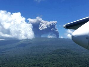
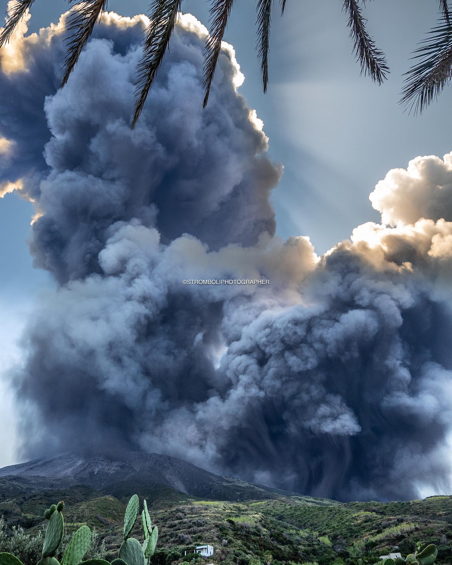
Italy , Stromboli :
Press release on Stromboli activity, July 11, 2024, 2:57 p.m. (12:57 UTC).
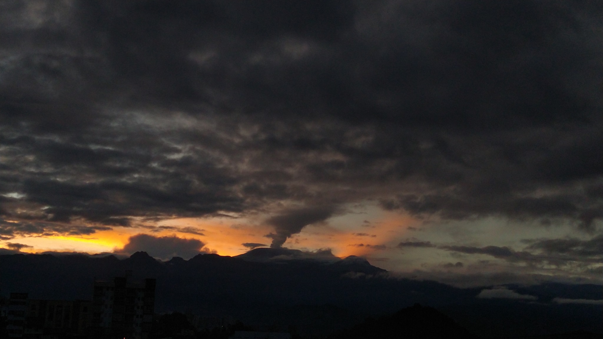
The National Institute of Geophysics and Volcanology, Osservatorio Etneo, communicates that from the analysis of images from the cameras of the monitoring network and INGV personnel in the field, it is possible to observe that at approximately 12:07 UTC, a paroxysmal event occurred at the summit craters. This activity produced an eruptive column and a pyroclastic flow along the Sciara del Fuoco. The flow propagated into the sea for tens of meters at the coastline. The phenomenon along the Sciara ended around 12:10 UTC.

From a seismic point of view, from 12:07 UTC, all Stromboli stations recorded a seismic transient associated with a sequence of explosive events with a total duration of approximately 8 minutes, including the most energetic (12:08 p.m.: 50 UTC) can be associated with the paroxysmal event occurring at the summit craters. The average tremor amplitude reached a very high level during the paroxysmal event followed by a rapid decrease until it currently reached the average level.
Concerning the permanent deformation monitoring networks, the sensors of the inclinometer and GNSS stations do not present significant variations.
Further updates will be communicated shortly.
Source : INGV
Photo : Stromboli stati d’animo / Sebastiano Cannavo.
Philippines , Taal :
Notice of elevated sulfur dioxide degassing from Taal Volcano. 11 July 2024 , 06:00 PM.
A total of 11,745 tonnes/day of volcanic sulfur dioxide or SO2 gas emission from the Taal Main Crater was measured today, 11 July 2024. Visual monitors show that degassing generated moderate to voluminous plumes that rose 2,400 meters above the Main Crater before being drifted to the general west by strong winds. Taal has emitted an average of 7,777 tonnes/day of SO2 for the year and has been continuously degassing voluminous concentrations of SO2 since 2021. PAGASA also forecasts a probable weakening of wind in the coming days which may lead to potential SO2 accumulation and volcanic smog or vog formation over the Taal region. Prolonged exposure to volcanic SO2 can cause irritation of the eyes, throat and respiratory tract. People who may be particularly sensitive are those with health conditions such as asthma, lung disease and heart disease, the elderly, pregnant women and children.
DOST-PHIVOLCS reminds the public that Alert Level 1 prevails over Taal Volcano, which means that it is still at low-level unrest and should not be interpreted to have ceased the threat of eruptive activity and volcanic hazards. At Alert Level 1, sudden steam-driven or phreatic explosions, volcanic earthquakes, minor ashfall and lethal accumulations or expulsions of volcanic gas can occur and threaten areas within TVI. Furthermore, degassing of high concentrations of volcanic SO2 continues to pose the threat of potential long-term health impacts to communities around Taal Caldera that are frequently exposed to volcanic gas. DOST-PHIVOLCS strongly recommends that entry into TVI, Taal’s Permanent Danger Zone or PDZ, especially the vicinities of the Main Crater and the Daang Kastila fissure, must remain strictly prohibited. Local government units are advised to continuously monitor and assess volcanic SO2 exposure of, and potential impacts on, their communities and undertake appropriate response measures to mitigate these hazards.
DOST-PHIVOLCS is closely monitoring Taal Volcano’s condition and any new significant development will be immediately communicated to all stakeholders.
Source : DOST-PHIVOLCS
Photo : JhuLia Mendoza ( archive)
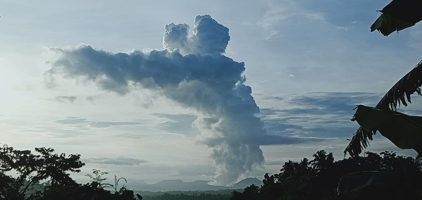
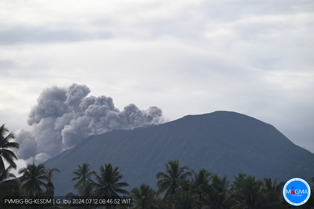
Indonesia , Ibu :
An eruption of Mount Ibu occurred on Friday 12 July 2024 at 04:59 WIT with the height of the ash column observed at ±500 m above the summit (±1825 m above sea level). The ash column was observed to be gray with thick intensity oriented towards the Northeast. This eruption was recorded on a seismograph with a maximum amplitude of 12 mm and a duration of 113 seconds.
VOLCANO OBSERVATORY NOTICE FOR AVIATION – VONA
Issued : July 11 , 2024
Volcano : Ibu (268030)
Current Aviation Colour Code : ORANGE
Previous Aviation Colour Code : orange
Source : Ibu Volcano Observatory
Notice Number : 2024IBU054
Volcano Location : N 01 deg 29 min 17 sec E 127 deg 37 min 48 sec
Area : North Maluku, Indonesia
Summit Elevation : 4240 FT (1325 M)
Volcanic Activity Summary :
Eruption with volcanic ash cloud at 19h59 UTC (04h59 local).
Volcanic Cloud Height :
Best estimate of ash-cloud top is around 5840 FT (1825 M) above sea level or 1600 FT (500 M) above summit. May be higher than what can be observed clearly. Source of height data: ground observer.
Other Volcanic Cloud Information :
Ash cloud moving to northeast. Volcanic ash is observed to be gray. The intensity of volcanic ash is observed to be thick.
Remarks :
Eruption recorded on seismogram with maximum amplitude 12 mm and maximum duration 113 second.
Source et photo : Magma Indonésie.
Colombia , Nevado del Ruiz :
Manizales, July 9, 2024, 6:30 p.m. Weekly activity bulletin: Nevado del Ruiz Volcano.
Regarding the monitoring of the activity of the NEVADO DEL RUIZ VOLCANO, the COLOMBIAN GEOLOGICAL SERVICE (SGC), an entity attached to the MINISTRY OF MINES AND ENERGY, reports that:
In the week of July 2 to 8, 2024, the volcano continued with unstable behavior. Compared to the previous week, the main variations in the parameters monitored were:
– Seismic activity associated with the fracturing of rocks within the volcanic edifice has decreased in the number of earthquakes recorded and maintained similar levels in seismic energy released. The earthquakes were of low energy level (magnitudes less than 1) and were located in the Arenas crater and, in a dispersed manner, on the different flanks of the volcano, at distances generally less than 5 km from the crater. The depths of the events varied between less than 1 and 6 km from the volcano summit. Seismic activity linked to the activity of the lava dome (protrusion or mound) located at the bottom of the crater has also decreased. This type of seismicity was of short duration and low energy level.
– Seismicity linked to fluid dynamics inside volcanic conduits has increased in the number of earthquakes recorded and in the seismic energy released. Although the recording of long-duration signals continued, these occurred to a lesser extent. The energy levels of the seismic signals were variable with low to moderate values.
Thanks to the cameras used to monitor the volcano, added to reports from those responsible for the Los Nevados National Natural Park, it was possible to confirm several ash emissions associated with some of these seismic events. Additionally, temperature changes of the emitted material were confirmed using FLIR (thermographic) cameras.
– On the volcano, the emission of water vapor and gas into the atmosphere from the Arenas crater continues.
Sulfur dioxide (SO₂) outgassing rates were variable and continued to increase slightly. The maximum height of the gas column during the week, estimated above the summit of the volcano, was 800 m vertical and 1,400 m dispersed, corresponding to the emission of ash recorded on July 2 at 6:54 a.m. . mr. The direction of dispersion of the gas column was variable with a preferential trend towards the northwest of the volcano.
– When monitoring surface activity from satellite monitoring platforms, the detection of thermal anomalies at the bottom of Arenas Crater continued to be limited by the heavy cloudiness conditions in the area. However, just this week, reports were obtained of some anomalies being detected with low energy levels.
Source : SGC
Photo : Julian Fernando Aranzazu Henao.
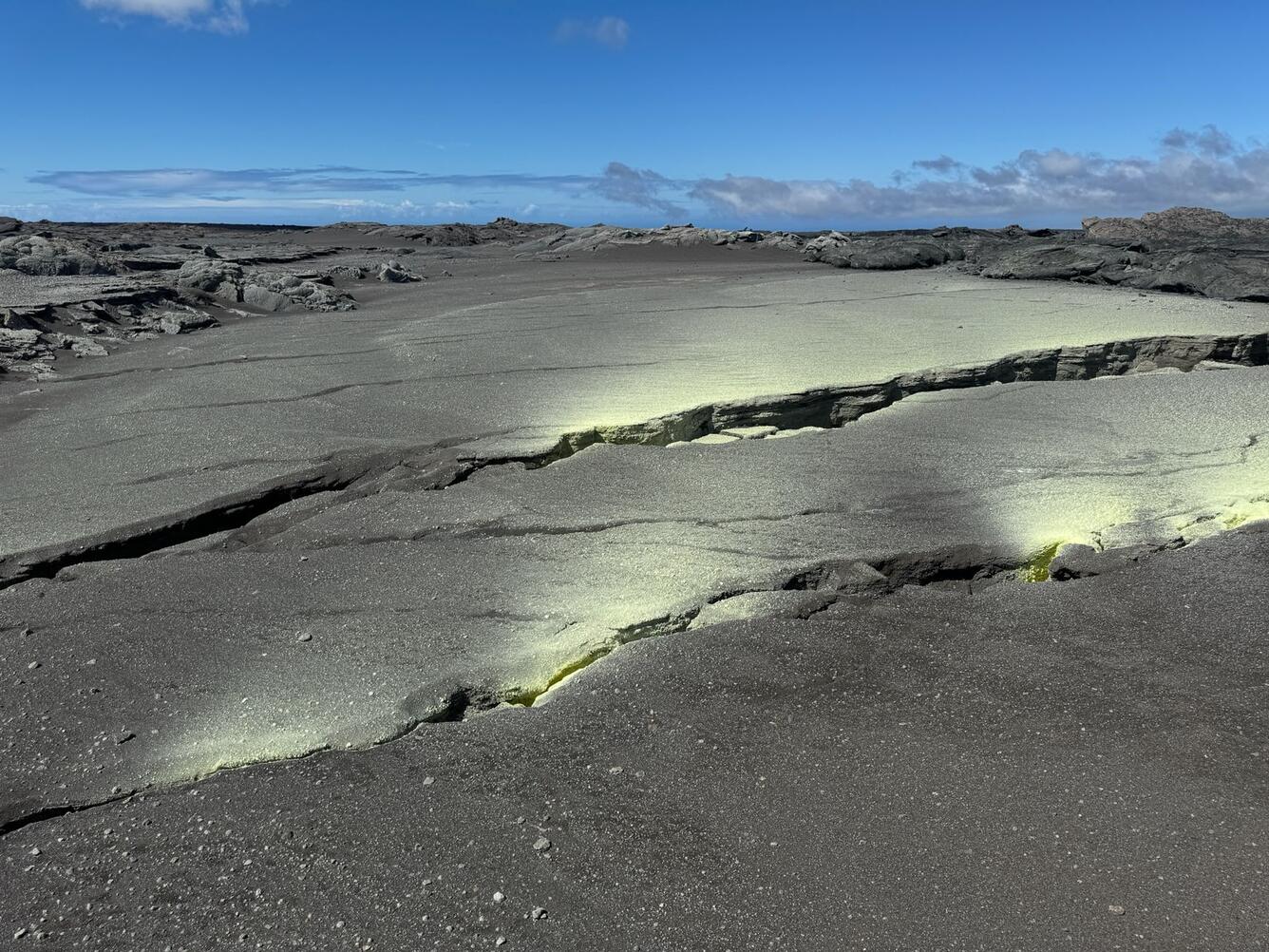
Hawaii , Kilauea :
Thursday, July 11, 2024, 8:21 AM HST (Thursday, July 11, 2024, 18:21 UTC)
19°25’16 » N 155°17’13 » W,
Summit Elevation 4091 ft (1247 m)
Current Volcano Alert Level: ADVISORY
Current Aviation Color Code: YELLOW
Activity Summary:
Kīlauea volcano is not erupting. Earthquake activity beneath Kalueapele has increased over the past 24 hours, and activity beneath the upper East Rift Zone has decreased. Longer-term, gradual inflation of the summit and upper rift zones persists since the end of the June 3, 2024, eruption. Any substantial increases in seismicity and/or deformation could result in a new eruptive episode, but there are no signs of an imminent eruption at this time.
Summit and Upper Rift Zone Observations:
Over the past 24 hours, there were approximately 52 earthquakes detected beneath Kaluapele (Kīlauea caldera) and 5 earthquakes detected beneath the upper East Rift Zone, mostly at depths of 0–2 km (0.0–1.2 mi) beneath the ground surface. Counts increased beneath Kaluapele and decreased in the upper East Rift Zone compared to the previous day (during which there were 20 events detected beneath the summit and 30 events detected beneath the upper East Rift Zone). All earthquake counts are well below the counts recorded during the June 27–July 1 upper East Rift Zone swarm. All events were smaller than M2 except for M2.0, M2.1, M2.3, and M3.3 earthquakes in the summit region. Tiltmeters in Kīlauea summit region (instruments SDH, southwest of the summit, and UWE, northwest of the summit) show longer-term minor increases in inflationary ground deformation rates over the past day. Tiltmeter SDH has also shown very minor, short term tilt excursions (both deflationary and inflationary) over the last 24 hours. GPS instruments around the summit region continue to show longer-term, gradual inflation since the end of the June 3, 2024, eruption. The most recent measurement of the summit’s SO2 emission rate was approximately 61 tonnes per day on July 9, 2024.
Middle and Lower Rift Zone Observations:
Rates of seismicity and ground deformation beneath the middle and lower East Rift Zone and lower Southwest Rift Zone remain low. Recent eruptive activity and ongoing unrest have been restricted to the summit and upper rift zone regions. Measurements from continuous gas monitoring stations downwind of Puʻuʻōʻō in the middle East Rift Zone—the site of 1983–2018 eruptive activity—remain below detection limits for SO2, indicating that SO2 emissions from Puʻuʻōʻō are negligible.
Source : HVO
Photo : USGS / M. Patrick.