August 16 , 2024.
Italy , Stromboli :
15 August 2024, 20:59 (18:59 UTC), Statement on the activity of Stromboli.
The National Institute of Geophysics and Volcanology, Osservatorio Etneo, reports that, from surveillance cameras and INGV personnel on the ground, from around 16:45 UTC, a lava overflow is observed in the Sciara del Fuoco, fed by the area of the North crater, the culmination of intense spattering activity. Currently, the lava front is between 500 and 400 m above sea level. At the same time, explosive activity continues from the northern area of the crater.
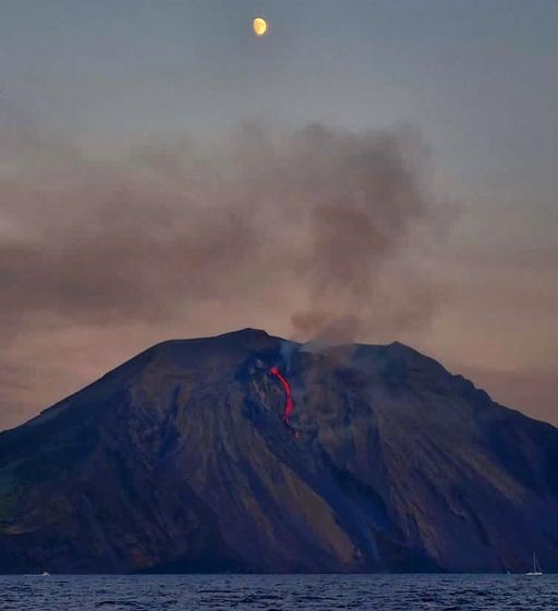
From 12:00 UTC, the volcanic tremor reached very high values, even exceeding the level recorded on the night of 13-14 August. Currently, despite significant fluctuations, a trend towards an increase in the amplitude of the tremors seems to persist.
The signals from the GNSS and inclinometric networks, monitoring ground deformations, do not show significant variations.
Further updates will be communicated shortly.
Source : INGV
Photo : Stromboli stati d’animo / Sebastiano Cannavo.
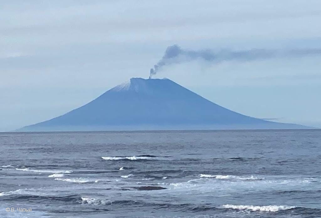
Russia / Kuril Islands , Alaid :
VOLCANO OBSERVATORY NOTICE FOR AVIATION (VONA)
Issued: August 16 , 2024
Volcano: Alaid (CAVW #290390)
Current aviation colour code: ORANGE
Previous aviation colour code: green
Source: KVERT
Notice Number: 2024-52
Volcano Location: N 50 deg 51 min E 155 deg 33 min
Area: Northern Kuriles, Russia
Summit Elevation: 2339 m (7671.92 ft)
Volcanic Activity Summary:
Alaid volcano is not erupting. A plume of resuspended ash from a southern flank of the volcano is extending for 45 km to the south of the volcano.
A moderate activity of the volcano continues. Ongoing activity could affect low-flying aircraft.
Volcanic cloud height:
2500-3000 m (8200-9840 ft) AMSL Time and method of ash plume/cloud height determination: 20240816/0220Z – Himawari-9 14m15
Other volcanic cloud information:
Distance of ash plume/cloud of the volcano: 45 km (28 mi)
Direction of drift of ash plume/cloud of the volcano: SSE / azimuth 160 deg
Time and method of ash plume/cloud determination: 20240816/0220Z – Himawari-9 14m15
Remarks: resuspended ash
Source : Kvert
Photo : V. Chaly ( 18/9/2022)
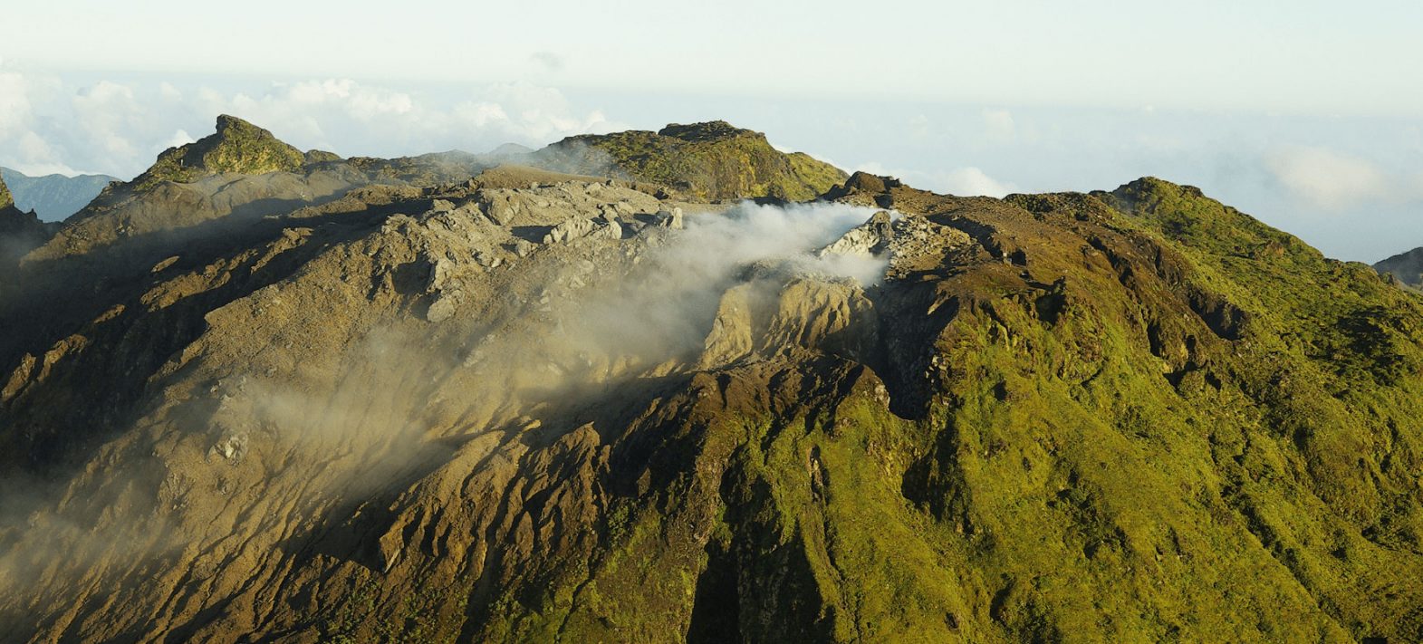
New Zealand , White Island :
Update from gas flight: volcanic gas emissions increase with minor ash emissions continuing. Volcanic Alert Level remains at Level 3 and Aviation Colour Code remains at Orange.
Published: Fri Aug 16 2024 11:40 AM
A gas flight on Wednesday (14 Aug 2024) has confirmed an increase in the amount of volcanic gas being emitted from Whakaari/White Island and that the plumes come from a new source vent. Satellite data also suggests a modest increase in the amount of volcanic ash in the plume since last Friday (9 Aug) compared to the beginning of the eruptive activity in May 2024. There is a very low likelihood of ash impacting the mainland.
The Volcanic Alert Level remains at Level 3 (minor eruption) and the Aviation Colour Code remains at Orange.
During our gas flight on Wednesday, we measured a large increase in the amount of volcanic gases being emitted from the new active vent since our last gas flight on 18 July (Fig. 1). Minor amounts of volcanic ash were also observed in the plume, downwind from the island (Fig. 2). The gas and ash are being emitted from a vent about 10–15 m across. These observations are consistent with the satellite observations from the Wellington Volcanic Ash Advisory Centre (NZ MetService) and our GeoNet webcams at Whakatāne and Te Kaha.
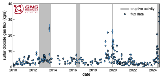
Figure 1. Amount of sulphur dioxide (SO2) gas (blue circles) emitted since January 2010. Periods of eruptive activity are shown by grey bands in the background. SO2 emissions have increased since the volcanic activity increased at the end of May 2024 (grey region to the far right of the plot).
We were also able to obtain a small ash sample during the flight and initial analyses are consistent with it been derived from a shallow magma source.
These new data confirm there has been a change in the eruptive activity from the island since the beginning of August. There is more gas, and more continuous minor entrainment of volcanic ash in the hot plume. This is consistent with magma (molten rock) being close to the surface and driving the activity. This is part of the typical eruptive cycles seen at Whakaari/White Island. Based on past eruptive episodes over the past 30 years, this activity could continue for some time, maybe weeks to months.
NZ MetService has been able to track the volcanic ash in the plume for tens of kilometres from the island over the past week due to clear sky conditions around Whakaari/White Island. Plumes have reached up to 2 kilometres elevation, under calm conditions.
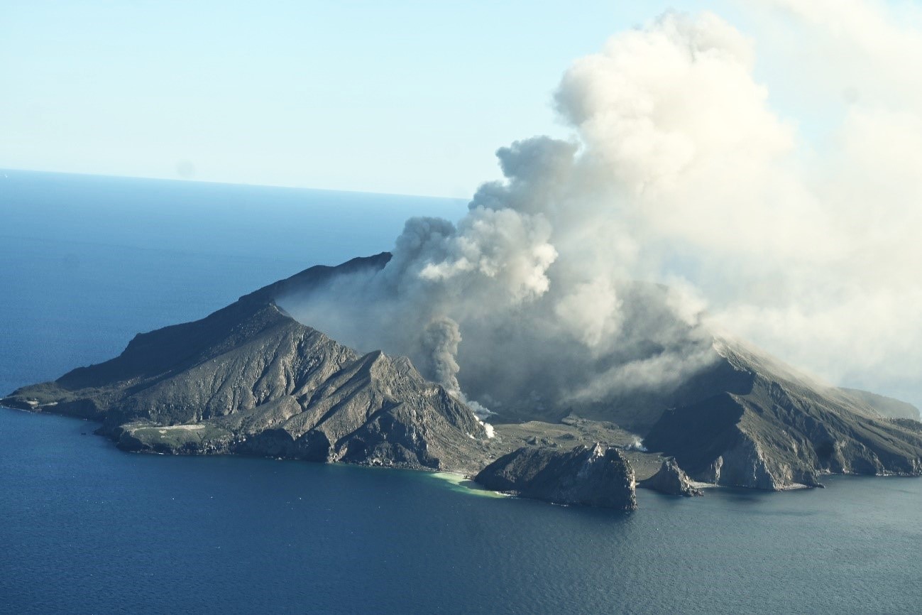
Figure 2. Picture of the minor ash emission from the active vent that is feeding the plume from Whakaari/White Island during Wednesday’s gas flight (14/08/24).
The concentrations of volcanic ash are very low and sometimes difficult to detect. As the weather changes the plume may at times be blown towards the Bay of Plenty coast. However, at the current level of ash emission, there is a very low likelihood of ash impacting the mainland. The level of volcanic activity would have to change significantly for this likelihood to increase.
We will continue to closely monitor volcanic activity at Whakaari with remote cameras, satellite imagery, and regular monitoring flights. We will provide updates when information becomes available.
Source : Geonet / Ery Hughes (she/her) / Duty Volcanologist
Photos : Geonet
Colombia , Nevado del Ruiz :
Manizales, August 13, 2024, 4:30 p.m.
From the monitoring of the activity of the Nevado del Ruiz volcano, the Colombian Geological Survey (SGC), an entity attached to the Ministry of Mines and Energy, reports that:
During the week of August 6 to 12, 2024, the volcano continued with unstable behavior. Compared to the previous week, the main variations in the monitored parameters were:
– The seismic activity associated with the fracturing of rocks inside the volcanic edifice decreased in the number of earthquakes recorded and increased in the seismic energy released.
The earthquakes were located mainly on the south-southeast and northeast flanks of the Arenas crater and, to a lesser extent, on the northwest, southeast and north flanks of the volcano, at distances less than 13 km from the crater. The depths of the events varied between less than 1 km and 9 km from the summit of the volcano. The largest magnitude of the week was 2.2, corresponding to the earthquake recorded on August 10 at 22:11, located 2 km south-southeast of the crater, at a depth of 3 km.

– Seismicity related to fluid activity inside volcanic conduits decreased in the number of earthquakes recorded and in the seismic energy released. Energy levels ranged from low to moderate values. Thanks to the cameras used to monitor the volcano, it was possible to confirm several ash emissions and changes in the temperature of the emitted materials. Both phenomena were associated with some of these seismic events.
– The emission of water vapor and gas into the atmosphere from the Arenas crater continues. Sulfur dioxide (SO₂) degassing rates were variable, with similar behavior. On August 6, the gas column reached a maximum vertical height of 700 m and a dispersion of 900 m. The dispersion direction of the gas column maintained a preferential trend towards the northwest of the volcano.
– When monitoring thermal anomalies at the bottom of the Arenas crater, from satellite monitoring platforms, their detection continues to be limited by the atmospheric conditions prevailing in the area. During the week, only one low-energy anomaly was detected.
The alert status for volcanic activity remains at Yellow: active volcano with changes in the behavior of the base level of the monitored parameters and other manifestations.
Source et photo : SGC
La Guadeloupe , La Soufrière :
Monthly bulletin, Institut de physique du globe de Paris / Observatoire volcanologique et seismologique de Guadeloupe .
July 2024
La Soufrière Volcano
– Seismicity: 532 volcano-tectonic (VT) earthquakes occurred regularly (no swarms) at less than 1 km depth under the Soufrière dome.
– Deformation: after a slowdown in early 2024, the opening of the dome summit has resumed a normal regime
– Gases and fluids:
– the temperatures and pH of the fumaroles are close to the values measured in recent months.
– the composition of deep gases (non-condensable) does not show any major change that could reflect a rise in magma.
– in relation to rainfall, the level of Lake Tarissan has risen by more than 5 meters
– Thermal springs:
The temperatures of the springs located at altitude on the southern flank of La Soufrière continue to gradually increase. The Carbet Echelle spring, which had gradually disconnected from the hydrothermal system since 1978, has shown an increase in HCO3 content and a decrease in pH since 2018, which could reflect an input of magmatic CO2.
Based on the observations summarized in this bulletin, and in accordance with the provisions provided by the authorities, the volcanic alert level remains:
Vigilance: Yellow
Regional telluric activity
– Low intensity activity with 269 earthquakes (M < 3.9) recorded on regional fault networks
– 185 earthquakes occurred in the Saintes sector, including 148 earthquakes between July 10 and 12
– No earthquakes were felt by the population.
Source et photo : OVPF IPGP.