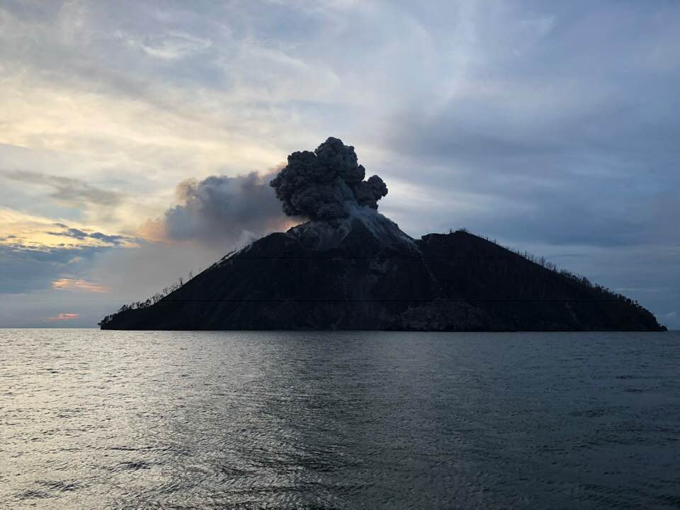
December 06 , 2018. EN. Japan : Kirishimayama , Papua New Guinea : Kadovar , Guatemala : Fuego , Alaska : Veniaminof .

December 06 , 2018.


Japan , Kirishimayama :

31.934°N, 130.862°E
Elevation 1700 m

JMA reported that vigorous fumarolic activity on the S side of Iwo-yama (also called Ioyama), on the NW flank of the Karakuni-dake stratovolcano in the Kirishimayama volcano group, continued during 30 November-3 December. Fumarolic plumes rose 100 m above the vent, and hot mud was ejected from the vent. A hot pool of water persisted on the S side of the area. Fumarolic plumes rose 50 m above a vent 500 m W of Iwo-yama. The Alert Level remained at 2 (the second lowest level on a scale of 1-5).

Kirishimayama is a large group of more than 20 Quaternary volcanoes located north of Kagoshima Bay. The late-Pleistocene to Holocene dominantly andesitic group consists of stratovolcanoes, pyroclastic cones, maars, and underlying shield volcanoes located over an area of 20 x 30 km. The larger stratovolcanoes are scattered throughout the field, with the centrally located, 1700-m-high Karakunidake being the highest. Onamiike and Miike, the two largest maars, are located SW of Karakunidake and at its far eastern end, respectively. Holocene eruptions have been concentrated along an E-W line of vents from Miike to Ohachi, and at Shinmoedake to the NE. Frequent small-to-moderate explosive eruptions have been recorded since the 8th century.

Source: Agence météorologique japonaise (JMA) , GVP.

Photo : S. Nakano 08.03.2011 / Geological survey of Japan.


Papua New Guinea , Kadovar :

Based on satellite data and wind model data, the Darwin VAAC reported that during 27-28 November ash plumes from Kadovar rose to an altitude of 0.9 km (3,000 ft) a.s.l. and drifted SE and E. On 2 December ash plumes rose to 1.2 km (4,000 ft) a.s.l. and drifted WSW and W.


The 2-km-wide island of Kadovar is the emergent summit of a Bismarck Sea stratovolcano of Holocene age. Kadovar is part of the Schouten Islands, and lies off the coast of New Guinea, about 25 km N of the mouth of the Sepik River. The village of Gewai is perched on the crater rim. A 365-m-high lava dome forming the high point of the andesitic volcano fills an arcuate landslide scarp that is open to the south, and submarine debris-avalanche deposits occur in that direction. Thick lava flows with columnar jointing forms low cliffs along the coast. The youthful island lacks fringing or offshore reefs. No certain historical eruptions are known; the latest activity was a period of heightened thermal phenomena in 1976. The first confirmed historical eruption at Kadovar began around mid-day local time on 5 January 2018.

Source: : Darwin Volcanic Ash Advisory Centre (VAAC)

Photo : Philip Stern via Sherine France.


Guatemala , Fuego :

Type of activity: Vulcanian
Morphology: Composite Stratovolcano
Geographical location: 14 ° 28’54˝ N Latitude; 90 ° 52’54˝ Longitude O.
Height: 3,763msnm
Weather conditions: Clear weather
Wind: North East 8 km / h
Precipitation: 8.3 mm

Activity:
White degassing fumaroles are observed at a height of approximately 4,500 m above sea level, dispersing to the west and southwest. We report 5 to 12 weak, moderate, and strong explosions per hour, ejecting columns of gray ash at an approximate height of 4500 to 5000 m (14764 to 16404 ft) that are dispersed to the west and southwest over a distance of about 20 km to 25 kilometers. Rumblings with weak shock waves generate vibrations in homes near the volcano. Incandescent impulses at an approximate height of 150 to 200 meters above the crater generate weak avalanches along the crater contour and towards the Seca, Taniluya, Ceniza, Trinidad, Las Lajas and Honda ravines. Ash falls are reported in the communities of Panimache I and II, Morelia, Santa Sofia, El Porvenir, Finca Palo Verde, Sangre de Cristo, Yepocapa and others located in this direction. Due to the wind acceleration, fine materials are observed moving west, south and southwest over a distance of 15 to 20 kilometers.

Source : Insivumeh.

Photo : Rudy Giron


Alaska , Veniaminof :

56°11’52 » N 159°23’35 » W,
Summit Elevation 8225 ft (2507 m)
Current Volcano Alert Level: WATCH
Current Aviation Color Code: ORANGE


Veniaminof volcano continues to erupt lava from the cone within its ice-filled summit caldera. Satellite views of the volcano over the past day have been obscured by clouds. A high-resolution satellite image acquired on December 2, 2018 shows a third lobe of lava extending a short distance down the southeast flank of the intracaldera cone and onto the snow and ice. No acoustic signals have been recorded by regional infrasound sensors over the past 24 hours. Steady, low-level tremor has been detected in seismic data over the past day.

Source : AVO

Photo : Thomas Jøhnk

06 Décembre 2018. FR . Japon : Kirishimayama , Papouasie Nouvelle Guinée : Kadovar , Guatemala : Fuego , Alaska : Veniaminof .

06 Décembre 2018.


Japon , Kirishimayama :

31,934 ° N, 130,862 ° E
Altitude 1700 m.

Le JMA a indiqué que l’activité fumerolienne vigoureuse du côté sud d’Iwo-yama (également appelé Ioyama), sur le flanc Nord-Ouest du stratovolcan de Karakuni-dake dans le groupe du volcan Kirishimayama, s’est poursuivie du 30 novembre au 3 décembre. Les panaches de fumeroles s’élevaient à 100 m au-dessus de l’évent et de la boue chaude était expulsée de l’évent. Un bassin d’eau chaude persistait du côté Sud de la zone. Les panaches s’élevaient à 50 m au-dessus d’un évent à 500 m à l’Ouest d’Iwo-yama. Le niveau d’alerte est resté à 2 (le deuxième niveau le plus bas sur une échelle de 1 à 5).

Kirishimayama est un groupe important de plus de 20 volcans du Quaternaire situés au Nord de la baie de Kagoshima. Le groupe , essentiellement andésitique du Pléistocène tardif à l’holocène , est constitué de stratovolcans, de cônes pyroclastiques, de maars et de volcans-boucliers sous-jacents situés sur une superficie de 20 x 30 km. Les stratovolcans les plus grands sont dispersés dans tout le champ, le Karakunidake situé au centre, culminant à 1 700 m, étant le plus élevé. Onamiike et Miike, les deux plus grands maars, sont situés au Sud-Ouest du Karakunidake et à son extrémité extrême Est, respectivement. Les éruptions de l’Holocène se sont concentrées le long d’une ligne d’évents orienté Est-Ouest allant de Miike à Ohachi et à Shinmoedake au Nord-Est. Des éruptions explosives légères à modérées fréquentes ont été enregistrées depuis le 8ème siècle.

Source: Agence météorologique japonaise (JMA) , GVP.

Photo : S. Nakano 08.03.2011 / Geological survey of Japan.


Papouasie Nouvelle Guinée , Kadovar :

Sur la base de données satellitaires et de modèles de vent, le VAAC de Darwin a signalé que du 27 au 28 novembre, les panaches de cendres du Kadovar avaient atteint une altitude de 0,9 km (3000 ft)  et avaient dérivés vers le Sud-Est et l’Est  . Le 2 décembre, le panache de cendres a atteint 1,2 km d’altitude et a dérive vers l’Ouest-Sud-Ouest et l’Ouest.


L’île de Kadovar, large de 2 km, est le sommet émergent d’un stratovolcan de la mer de Bismarck de l’âge holocène. Le Kadovar fait partie des îles Schouten et se situe au large de la côte de la Nouvelle-Guinée, à environ 25 km au Nord de l’embouchure de la rivière Sepik. Le village de Gewaï était perché sur le bord du cratère. Un dôme de lave de 365 m de haut, formant le point culminant du volcan andésitique, remplit un escarpement de glissement de terrain arqué ouvert vers le Sud, et des dépôts d’avalanches de débris sous-marins apparaissent dans cette direction. Des coulées de lave épaisses avec jointures en colonnes forment des falaises basses le long de la côte. La jeune île manque de récifs frangeants ou offshore. Aucune éruption historique certaine n’est connue; une des dernière activité a été une période de phénomènes thermiques exacerbés en 1976. La première éruption historique confirmée sur Kadovar a débuté vers 5h, heure locale, le 5 janvier 2018.

Source: Centre d’avis de cendres volcaniques Darwin (VAAC)

Photo : Philip Stern via Sherine France.


Guatemala , Fuego :

Type d’activité: Vulcanienne
Morphologie: Stratovolcan composite
Localisation géographique: 14 ° 28’54˝ Latitude N; 90 ° 52’54˝ Longitude O.
Hauteur: 3,763msnm
Conditions météorologiques: Temps clair
Vent: Nord-Est 8 km / h
Précipitation: 8.3 mm

Activité:
Des fumerolles blanches de dégazage sont observées à une hauteur approximative de 4 500 m d’altitude se dispersant vers l’Ouest et le Sud-Ouest. Nous rapportons 5 à 12 explosions faibles , modérées et fortes par heure, éjectant des colonnes de cendres grises à une hauteur approximative comprise entre 4500 et 5000 m  (14764 à 16404 ft) qui se dispersent vers l’Ouest et le Sud-Ouest sur une distance d’environ 20 km à 25 kilomètres. Des grondements avec des ondes de choc faibles génèrent des vibrations dans les maisons près du volcan. Des impulsions incandescentes à une hauteur approximative comprise entre 150 et 200 mètres au-dessus du cratère génèrent de faibles avalanches sur le contour du cratère et vers les ravins Seca, Taniluyá, Ceniza, Trinidad, Las Lajas et Honda. Des chutes de cendres sont signalées dans les communautés de Panimache I et II, Morelia, Santa Sofia, El Porvenir, Finca Palo Verde, Sangre de Cristo, Yepocapa et d’autres situées dans cette direction. En raison de l’accélération du vent, on observe des matériaux fins se déplaçant vers l’Ouest, le Sud et le Sud-Ouest sur une distance comprise entre 15 et 20 kilomètres.

Source : Insivumeh.

Photo : Rudy Giron


Alaska , Veniaminof :

56 ° 11’52 « N 159 ° 23’35 » W,
Altitude du sommet : 8225 pi (2507 m)
Niveau d’alerte volcanique actuel: ATTENTION
Code couleur de l’aviation actuel : ORANGE


Le volcan Veniaminof continue son éruption de lave depuis le cône sommital jusque dans sa caldera de glace. La vue satellite du volcan au cours de la journée écoulée a été obscurcie par les nuages. Une image satellite à haute résolution acquise le 2 décembre 2018 montre un troisième lobe de lave s’étendant sur une courte distance le long du flanc Sud-Est du cône intra-caldera jusque sur la neige et la glace. Aucun signal acoustique n’a été enregistré par les capteurs d’infrasons régionaux au cours des dernières 24 heures. Des tremors réguliers et de faible intensité ont été détectés dans les données sismiques au cours de la journée écoulée.

Source : AVO

Photo : Thomas Jøhnk

14 Novembre 2018. FR. Islande : Bárðarbunga , Colombie : Chiles / Cerro Negro , Kilauea : Hawaii , Indonésie : Ibu .

14 Novembre 2018.


Islande , Bárðarbunga :

Deux puissants tremblements de terre sous le Bárðarbunga hier soir.

Un essaim de tremblement de terre a été détecté sous le volcan Bárðarbunga hier soir, lundi 12 Novembre . L’essaim comprenait deux séismes de magnitude supérieure à M3,0 dans la partie Nord-Est du volcan , un tremblement de terre de magnitude M3,6 avec un épicentre situé à 2,5 km au Nord du sommet du Bárðarbunga, à une profondeur de 10 km hier soir, à 19h21  , suivi de moins de deux minutes plus tard par un second puissant séisme de magnitude 3,3, à 3 km (1,9 mi) au Nord-Est du Bárðarbunga  , à une profondeur de 3 km.
Plus d’une douzaine de répliques plus petites ont été détectées sous le volcan.


Le Bárðarbunga , l’un des volcans les plus puissants d’Islande se cache sous la calotte glaciaire du glacier Vatnajökull. L’activité géothermique dans la caldera du volcan a fait fondre des chaudrons dans le glacier, de la vapeur s’échappant par des orifices de ventilation dans la glace. Photo / Jóhann K Jóhansson

Selon une déclaration du sismologue en poste à l’Office météorologique islandais, il n’y a aucun signe immédiat d’activité volcanique sur le Bárðarbunga et cette activité semble être la continuation des processus géologiques en cours depuis un certain temps.
Le système du Bárðarbunga montre une activité croissante depuis environ un an, après l’éruption de Holuhraun en 2014-2015 à la limite Nord du système volcanique .

Source : icelandmag.is

Photo : Jóhann K Johansson.


Colombie , Chiles / Cerro Negro :

Bulletin hebdomadaire d’activité des volcans Chiles et Cerro Negro.
Le niveau d’activité des volcans est maintenu au niveau : NIVEAU JAUNE ■ (III): CHANGEMENTS DANS LE COMPORTEMENT DE L’ACTIVITÉ VOLCANIQUE

Suite à l’activité des volcans CHILES et CERRO NEGRO, le COLOMBIAN GEOLOGICAL SERVICE (SGC) signale que:

Entre le 6 et le 12 novembre 2018, l’activité sismique dans la région des volcans Chiles – Cerro Negro a enregistré une diminution de la fréquence des séismes, passant d’environ 2600 tremblements de terre à près de 1400, l’énergie sismique se maintenant à des niveaux similaires à ceux rapportés les semaines précédentes. La prédominance de la sismicité liée à la fracturation de la roche à l’intérieur du bâtiment volcanique se poursuit (tremblements de terre de type volcano-tectoniques).

Les séismes ont été localisés pour la plupart vers le Sud et le Sud-Ouest du volcan Chiles, à des distances allant jusqu’à 10 km, des profondeurs comprises entre 0,6 et 13 km par rapport au sommet (4700 mètres d’altitude) et une magnitude locale maximale de M 2,7 sur l’échelle de Richter. Il faut souligner l’événement survenu le 8 novembre, qui a été rapporté comme ressenti par les habitants de la zone d’influence du volcan, l’événement était situé à 7 km de profondeur, à environ 15 km au Sud-Est du volcan.

Le service géologique colombien et l’institut de géologie de l’école polytechnique nationale d’Équateur suivent de près l’évolution de cette activité sismique et du phénomène volcanique et informent de manière opportune sur les changements détectés.

Source : SGC

Photo : Ingeominas.


Kilauea , Hawaii :

19 ° 25’16 « N 155 ° 17’13 » O,
Sommet : 4091 pieds (1247 m)
Niveau d’alerte volcanique actuel: AVIS
Code couleur de l’aviation actuel : JAUNE

Résumé d’activité:
Le volcan Kīlauea n’est pas en éruption. Les taux de sismicité, de déformation et de dégagement de gaz n’ont pas beaucoup changé au cours de la semaine écoulée. Les signaux de déformation sont compatibles avec le remplissage de la middle East Rift Zone.

Des conditions claires permettaient de bien voir le profond cratère du Pu‘u ‘Ō‘ō. Aucune lave active ou signes d’activité accrue n’ont été observés ici. Les parois du cratère révèlent une séquence claire de coulées de lave et de cendres qui ont construit le cône au début des années 1980.

Observations:
La surveillance du HVO au cours de la semaine écoulée révèle des taux de sismicité faibles au sommet et dans la zone de Rift Est (ERZ). Les tremblements de terre continuent de se produire principalement au sommet du Kīlauea et sur le flanc Sud, ainsi que de petites répliques subséquentes du séisme de magnitude 6,9 ​​du 4 mai 2018. La sismicité reste faible dans la ERZ inférieure.

Dans la ERZ, les inclinomètres situés près du Puʻu ʻŌʻō et plus à l’Est ne révèlent aucun changement au cours de la semaine écoulée. Au sommet, les inclinomètres ont également montré peu de changement cette semaine, à l’exception d’un petit événement DI (déflation-inflation).

Les émissions de dioxyde de soufre au sommet ont été en moyenne de 50 tonnes / jour, comme indiqué le 24 octobre, et de 75 tonnes / jour sur Puʻu ʻŌʻō le 23 octobre. Nos instruments n’ont pas détecté de dioxyde de soufre dans la ERZ inférieure.

La fissure 22 était active fin mai près de la subdivision de Lanipuna Gardens, qui est maintenant principalement ensevelie par des coulées de lave. Au cours des dernières phases d ’activité de la Fissure 22, de petites explosions de type strombolien ont construit un cône de cendre symétrique au-dessus de l’évent.


Des dangers sont toujours présents dans la zone d’éruption de la lower East Rift Zone (LERZ) et au sommet du Kīlauea. Les résidents et les visiteurs à proximité de fissures et des coulées de lave récemment actives doivent rester informés, se conformer aux avertissements du département de la Défense civile du comté d’Hawaï et être prêts, si nécessaire, à s’auto-évacuer dans l’éventualité peu probable d’une reprise de l’activité. Veuillez noter que le comté d’Hawaï maintient la fermeture de l’intégralité du champ d’écoulement et des évents et interdit l’accès à la zone sauf autorisation de la Défense civile.

L’observatoire hawaïen des volcans (HVO) continue de surveiller de près la sismicité, la déformation et les émissions de gaz du Kīlauea pour détecter tout signe de réactivation, et maintient une surveillance visuelle du sommet et de la zone de rift est. Le HVO continuera à publier une mise à jour hebdomadaire (tous les mardis) et des messages supplémentaires, en fonction des changements d’activité.

Source : HVO

Photos : HVO


Indonésie , Ibu :

Niveau d’activité de niveau II (WASPADA). Le G. Ibu (1340 m d’altitude) a été continuellement en éruption depuis 2008.
Depuis hier et jusqu’à ce matin, le pic volcanique a été clairement observé jusqu’à l’apparition du brouillard. La fumée issue du cratère est blanche / grise, la pression est faible à moyenne et d’intensité faible à moyenne; elle se situe autour de 200 à 800 m au dessus du sommet. Le vent souffle faible à modéré en direction du Nord-Est.

Grace aux sismographes , le 13 novembre 2018 il a été enregistré:
102 séismes d’éruption
200  tremblement de terre d’émission
24  tremblements de terre d’avalanche
3 tremblements de terre tectoniques lointains (dont un séisme ressenti , à MMI I-II sur l’échelle  )

Recommandation:
Les communautés autour du G. Ibu et les visiteurs / touristes ne doivent pas avoir d’activités , grimper et s’approcher dans un rayon de 2 km du cratère , avec une expansion sectorielle de 3,5 km vers les ouvertures dans la partie Nord du cratère actif du G. Ibu.

VONA:
Le dernier code VONA a été envoyé avec le code de couleur ORANGE,  le 22 octobre 2018 à 16h30, pour une éruption  dont la colonne de cendres avait une hauteur d’environ 1725 m ou environ 400 m au-dessus du sommet, la colonne de cendres se déplaçait vers l’Est.
Pour le statut normal du volcan: Les personnes / les touristes / les alpinistes ne passent pas la nuit et ne campent pas dans le cratère afin d’éviter la menace potentielle des gaz toxiques.

Source : PVMBG

Photo : Malmeuh on the road via Matthias Vollmer.

July 09 , 2018. EN. Chile : Copahue , Ecuador / Galapagos : Sierra Negra , Hawai : Kilauea , Ecuador : Reventador .

July 09, 2018.


Chile , Copahue :

During this period, forty-seven (47) seismic events classified as volcano-tectonic (VT) were recorded, associated with fracturing processes of rigid materials. The event with the highest energy showed a local magnitude (ML) equal to 2.3 and was located 6.3 km east of the active crater El Agrio, less than 0.5 km deep.

Similarly, 92 earthquakes associated with fluid dynamics within the volcanic edifice were recorded as long-period (LP) events, with reduced displacement values (DRc) of 2.2 cm2. Finally, 32 earthquakes of very long period type (VLP) were recorded, with reduced displacement values (DRc) of maximum 6 cm2.

The IP cameras installed in the vicinity of the volcano recorded a constant degassing of the active crater (El Agrio) with a maximum height of 300 m, whitish color and incandescence (June 30) during the night, when the climatological conditions allowed to observe the volcano. .

According to the analysis of the data obtained from five (05) GNSS geodetic monitoring stations, the surface displacements of the volcanic building during the evaluated period are observed, as can be observed in the monitoring lines that cross the active crater. Vertical rates have a maximum of 0.25 cm / month, so it is concluded that there is no evidence of a significant deformation process associated with volcano activity.

Sulfur Dioxide (SO2) emissions, recorded by Differential Absorption Spectrometry Equipment (DOAS), corresponding to Mellizas Station, located 5 km east-northeast of the active crater had a value for the period of 1696 +/- 233 T / day, and maximum values ​​of 4983 T / day reported on June 21st.

No thermal warnings were reported in the area associated with the volcanic building, based on data processed by the MIARVA (http://www.mirovaweb.it/) and by a thermal monitoring in near real time. global hot spots (MODVOLC) (http://modis.higp.hawaii.edu/).

The process of interaction between the surface hydrothermal system and magmatic contributions from deep layers continues, which is evidenced by the presence of incandescence observable at night. In this activity setting, minor phreatic explosions may occur. On the other hand, if the magmatic system reaches more superficial levels, the activity could evolve into continuous ash emissions or Strombolian activity as recorded in previous years.

In this scenario, the danger of explosions that may affect areas near the crater persists, therefore the alert level is maintained at:

YELLOW LEVEL: Changes in the behavior of volcanic activity – Probable time for an eruption: WEEKS / MONTH.

Observation: Dangerous area is considered to be the vicinity of the crater with a radius of 1 kilometer.

Source : Sernageomin


Ecuador / Galapagos , Sierra Negra :

INTRODUCTION
The Sierra Negra volcano, located south of Isabela Island, 24 km from Puerto Villamil, is one of the most active volcanoes in the Galapagos. He has presented 7 eruptions over the past 70 years. On June 26 of this year, the Sierra Negra volcano began its most recent eruptive period. This reactivation was preceded by a sharp increase in seismic signals in the number of earthquakes and their magnitude (13 earthquakes with magnitudes equal to 4.0 between 1 January and 22 June). It has also been observed a continuous raising of the caldera floor measured through high resolution GPS receivers and the analysis of satellite images. On June 26 at 3:15 am Galapagos time (TG) an event of amplitude from 5.3 to 10 hours before the beginning of the eruptive activity was recorded.

This activity was characterized by the emission of lava flows through cracks in the northern edge of the caldera and on the northwest flank of the volcano. The lava flows descended mainly on the northern flank of the volcano towards Elizabeth Bay and with smaller volumes inside the caldera. On July 1, a new episode of tremor that was followed by lava emissions in the Northwest flank, according to reports from staff of the Galapagos National Park in Isabela, was recorded. The two beginnings of volcanic reactivation and the state of eruptive activity of the volcano have been reported by the Geophysical Institute in three special reports in 2017 and twelve special reports in 2018.

RESTARTING THE ERUPTIVE ACTIVITY
The clearest indication of a new magmatic intrusion was the magnitude 5.2 earthquake at 4:30 pm (GMT) on July 4th. After this earthquake, there were 68 earthquakes under the Sierra Negra volcano with amplitudes ranging from M1.1 to M3.9. Today, at 17:00 TG (Ecuador time -1 h), the appearance of a seismic jolt was seen in the VCH1 station, located on the northeast edge of Sierra Negra volcano. On the other hand, an infrared image of the GOES16 satellite shows an increase in the intensity of the hot spot on the northwest side of the volcano, which had decreased in the previous days (Figure 1). This increase is observed from 17:00 TG today, and persists until now (20:00 TGi).
It is possible that this observation is associated with a new lava outlet.
These anomalies suggest a continuation of the eruptive process on the Sierra Negra volcano, with a new impulse of lava emission with a source on the northwest flank of the volcano.

Figure 1.- GOES hot spot on the northwest flank of Sierra volcano at 17:00 Galapagos time.

On the other hand, also in the satellite images, there is a weak column of steam / ash from said point towards the West. The Washington Volcanic Warning Center (VAAC) observed a cloud of ash up to 3,000 m in the southwest direction and another cloud with a slightly higher height (3,300 m) in the west.
In addition, the guards of the Isabela Galápagos Islands National Park carried out an inspection of the northern area of ​​the volcano tonight and confirmed the presence of strong noise emission and incandescence in the area near the beach.

CONCLUSIONS
The appearance of seismic tremors and the presence of thermal anomalies in the satellite images suggest the beginning of a new eruptive impulse, located on the northwest flank of the Sierra Negra volcano from 17h today, 7 July 2018. This has been confirmed by the reports of officials of the Galapagos National Park.
It is not recommended to approach the area of ​​activity. In the case of an ash fall or volcanic ash area, it is recommended that appropriate precautions be taken.
The IG-EPN maintains its vigilance and will report any significant change in volcanic activity.

Seismogram of the VCH1 station that shows the tremor signal since 5:00 pm GMT yesterday, July 7 (6:00 pm Continental time of Ecuador in the time scale next to the left margin), until 7:30 today 8 July .


Volcán Sierra Negra Special Report N ° 15 – 2018
Update of eruptive activity

SEISMIC ACTIVITY
The seismic tremor recorded in the VCH1 station from 17:00 GMT yesterday, continues until now (12:00 GMT) although showing a gradual decrease in its amplitude (energy levels), as seen in Figure 1. This tremor is not recorded in the other stations of the Galapagos seismic monitoring network of the Institute of Geophysics, suggesting that the signal source is superficial.

ASH CLOUDS
The Volcanic Ash Warning Center (Washington-VAAC) reported a cloud of steam and ash about 2000 m above the volcano. This column is directed to the southeast of the volcano, without affecting the inhabited area of ​​Isabela Island. The infrared image of the GOES16 satellite shows an increase in the intensity of the hot spot on the northwest flank of the volcano, which had decreased in the previous days (Figure 1). This increase was observed from 17:00 TG yesterday, and persists until now (10:00 TG), so it is deduced that the lava emission continues.

CONCLUSIONS
The persistence of seismic tremor and the presence of ash and satellites captured by thermal anomalies indicate the continuity of the process of eruptive Sierra Negra volcano. The eruptive activity now consists of an emission of lava flows from a source located in the lower part of the northwest flank of the volcano. According to seismic data from the Geophysical Institute, this lava emission increased significantly at 17:00 yesterday (7 July).
As eruptive activity persists, it is recommended not to approach the sources of emission of lava, or be located in the lower parts of these or near possible sites of arrival lava to the ocean.
In the event of a change in wind direction, slight ash falls may occur in the inhabited parts of the volcano.
The Institute of Geophysics will continue with careful monitoring of this volcano.

Source : IGEPN

Photos : Projects Abroad.


Hawai , Kilauea :

Sunday, July 8, 2018, 11:18 AM HST (Sunday, July 8, 2018, 21:18 UTC)

19°25’16 » N 155°17’13 » W,
Summit Elevation 4091 ft (1247 m)
Current Volcano Alert Level: WARNING
Current Aviation Color Code: ORANGE

Kīlauea Volcano Lower East Rift Zone

The eruption in the lower East Rift Zone (LERZ) continues with no significant change during the past 24 hours.

Fountains from Fissure 8 spatter cone continue to supply lava to the open channel with only small, short-lived overflows. The spatter cone is now about 55 m (180 ft) tall at its highest point, and fountains rarely rise above that point. As shown by the July 06 thermal map of the flow field, the main lava channel no longer directly enters the ocean—the open channel flow ends about 2 km (1.2 mi) inland of the coast

Lava continues to enter the ocean, however, from multiple points along the entire ocean entry area, primarily along the northern section. In addition, multiple ooze-outs fed flows on the north and the southwest edge of the main ‘a’ā flow field but neither had lava actively entering the ocean.

Fissure 22 was weakly spattering overnight.

Sommet du volcan Kīlauea

Un autre événement d’effondrement-explosion au sommet de Kīlauea s’est produit à 8h55 HST le 8 juillet avec l’énergie équivalente d’un séisme de magnitude 5,4. La sismicité a chuté brusquement par la suite et reste faible à ce moment. L’activité sismique devrait augmenter au cours des prochaines heures et culminer dans une autre explosion d’effondrement lundi. L’effondrement vers l’intérieur de la jante et des murs de Halema’uma’u continue en réponse à l’affaissement continu du sommet.

As the magma in the shallow reservoir below the summit flows into the East Rift zone, the soil above it crumbles, cracks and lowers. The Halema’uma’u crater dropped about 400 m (1300 ft) between early May and late June. Inward collapse of the surrounding Kilauea crater bottom doubled the diameter of the Halema’uma’u crater. The large flat block visible inside the Halema’uma’u is a piece of the bottom of the crater dropped in free fall. The view is oriented towards the Southwest.


Sunday, July 8, 2018, 3:15 a.m.: No Tsunami From 5.4-M Summit Collapse

Hawaiian Volcanoes Observatory reports a collapse/explosive event with energy equal to a 5.4 magnitude earthquake has occurred at Halema‘uma‘u Crater at 2:55 a.m.
The Pacific Tsunami Warning Center reports there is no tsunami threat to the Island of Hawai‘i.

CENTRE D’ALERTE DU PACIFIQUE TSUNAMI EWA BEACH
Un événement sismique s’est produit près du sommet du volcan KĪLAUEA. L’ÉVÉNEMENT EST PROBABLEMENT ASSOCIÉ À UNE ERUPTION DE SOMMET.
SES PARAMÈTRES PRÉLIMINAIRES SONT:

HEURE ORIGINE – 0255 HST 08 JUI 2018
COORDONNÉES – 19,4 NORD 155,2 OUEST
EMPLACEMENT – DANS LA RÉGION DU SOMMET DU VOLCAN DE KILAUEA
MAGNITUDE – 5.4
AUCUN TSUNAMI N’EST ATTENDU

Source : HVO , Big Island video news.

Photo :  Bruce Omori , USGS , 18 juin 2018, Kyle Anderson.


Reventador , Ecuador :

The Institute of Geophysics (IG) of the National Polytechnic School announced Tuesday (July 8, 2018) that the eruptive activity remains « high » on the volcano Reventador. From its crater, blocks rolled in the last hours from all sides up to 800 meters under the summit. The IG said that during the past few hours, the volcano remained partially clear and that during the night, an incandescence was observed in the crater, accompanied by the presence of blocks. On July 2, the GI reported the ash fall of the Reventador volcano. in the provinces of Pichincha (Andes) and Napo (Amazonia) In November 2002, an eruption of the Reventador raised a large cloud of ashes which, because of the winds, went as far as Quito and covered several parts of the capital. The Reventador volcano is located about 90 kilometers east of Quito, on a spur of the eastern branch of the Andean mountain range that gets lost with the beginning of the Amazon basin. 3,560 meters high, this volcano began its eruptive process in 2002 and was characterized by explosions, emissions of gas and ash, lava flows and lahars.

EPN Geophysical Institute – Ecuador

THE STATE OF THE VOLCANO REVENTADOR N ° 189
SUNDAY, JULY 8, 2018
High eruptive activity is maintained. The volcano remained partially cleared, during the night the crater was incandescent, accompanied by rolling blocks on all sides at 800 meters below the summit.
The Institute of Geophysics of the Ecole Polytechnique is attentive to the activity of the volcano and will inform any changes that may occur.

Source : El Comercio ( http://www.elcomercio.com/actualidad/bloques-erupcion-volcan-reventador-cumbre.html. )

04 Mai 2018. FR. Pu’u ‘Ō’ō / Kilauea , Piton de la Fournaise , Yellowstone , Kirishimayama.

04 Mai  2018.


Pu’u ‘Ō’ō / Kilauea , Hawai :

Avis d’activité volcanique HVO / USGS

Niveau d’alerte volcanique actuel: AVERTISSEMENT
Niveau d’alerte du volcan précédent: ATTENTION
Code de couleur actuel de l’aviation: ORANGE
Émise: jeudi 3 mai 2018, 17 h 35 HST
Source: Observatoire du volcan hawaïen
Numéro de l’avis
Lieu: N 19 deg 25 min L 155 deg 17 min
Altitude: 4091 ft (1247 m)
Région: Hawaii

Résumé de l’activité volcanique:

Une éruption a commencé dans la subdivision de Leilani Estates dans la zone inférieure du Rift Est du volcan Kilauea. Peu avant 17 heures, la lave a été confirmée à la surface à l’extrémité Est de la subdivision. La défense civile du comté d’Hawaii est sur les lieux et coordonne la réponse nécessaire, y compris l’évacuation d’une partie de la subdivision de Leilani.
Les résidents du district inférieur de Puna doivent rester vigilants, examiner les plans d’urgence individuels, familiaux et commerciaux, et surveiller de plus amples informations sur l’état du volcan. Les messages de défense civile du comté d’Hawaii peuvent être trouvés à http://www.hawaiicounty.gov/active-alerts/.


Observations récentes:
De nouvelles fissures ont été signalées à Leilani Estates tard cet après-midi. De la vapeur blanche, de la vapeur chaude et de la fumée bleue émanaient d’une zone de fissuration dans la partie Est de la subdivision. Les éclaboussures ont commencé à éclater peu avant 17 heures.
Le HVO et le comté d’Hawaï sont sur le terrain et effectuent des survols pour mieux identifier l’activité et identifier la direction de la lave qui coule.
Analyse de risque:
Les zones situées en aval de l’évent en éruption risquent de subir une inondation de lave. À ce moment-là, la zone générale de la subdivision Leilani semble la plus à risque.
Les phases d’ouverture des fissures d’ éruptions sont dynamiques. Des bouches d’aération supplémentaires et de nouvelles éruptions de lave peuvent se produire et pour le moment il n’est pas possible de dire où de nouveaux évents peuvent se produire.
Remarques: Les scientifiques de l’USGS Hawaiian Volcano Observatory continuent de suivre de près l’activité. D’autres mises à jour suivront à mesure que l’information deviendra disponible.


RAPPORT D’ACTIVITE DE L’OBSERVATOIRE DU VOLCAN D’HAWAIIAN
jeudi 3 mai 2018, 11 h 15 HNT (le jeudi 3 mai 2018, 21 h 15 TU)

19 ° 25’16 « N 155 ° 17’13 » W,
Sommet: 4091 pi (1247 m)
Niveau d’alerte volcanique actuel: ATTENTION
Code couleur actuel de l’aviation: ORANGE

À 10h30 HST, un tremblement de terre d’une magnitude préliminaire de M 5,0 au Sud du Pu’u’ōō a provoqué des chutes de pierres et peut-être un effondrement supplémentaire dans le cratère du Pu’u’Ōō , dans la zone Est du volcan Kīlauea.
Un panache de cendre de courte durée produit par cet événement s’est envolé vers le ciel et continue de se dissiper alors qu’il dérive vers le Sud-Ouest du Pu’u’ōō. 
A ce moment, le tremblement de terre de 10h30 n’a causé aucun autre changement sur le volcan Kīlauea. Le HVO continuera à suivre de près les données de surveillance pour tout changement.
Le HVO a des équipes de terrain qui travaillent le long de la zone du rift en ce moment. Le HVO affichera des informations et des photographies supplémentaires plus tard dans la journée.

MISE A JOUR QUOTIDIENNE DE L’OBSERVATOIRE DU VOLCAN D’HAWAIIAN

Jeudi 3 mai 2018, à 8 h 48 HNT (jeudi 3 mai 2018, 18:48 UTC)

19 ° 25’16 « N 155 ° 17’13 » W,
Sommet : 4091 pi (1247 m)
Niveau d’alerte volcanique actuel: ATTENTION
Code couleur actuel de l’aviation: ORANGE

Résumé: Les tremblements de terre et la déformation du sol liés à l’intrusion de magma dans la zone inférieure du Rift Est du Kilauea se poursuivent. L’inclinaison déflationniste au sommet du volcan s’est accompagnée d’une baisse du niveau du lac de lave dans le cratère Halema’uma’u.

Lower East Rift Zone:
L’activité sismique se poursuit dans la zone du Rift Est du volcan Kīlauea, à partir de la route 130 vers l’Est en direction de Kapoho. L’intensité de la sismicité a légèrement diminué du jour au lendemain et la tendance à la migration vers l’Est de l’activité sismique semble s’être ralentie ou avoir cessé. Aucune diminution des séismes n’a été détectée. La station GPS du HVO dans la zone continue de montrer des mouvements liés à la déformation du sol en réponse à l’intrusion en cours.
Les fissures trouvées sur un certain nombre de routes à Leilani Estates hier reflètent probablement des contraintes dues à la déformation du sol causée par l’intrusion en cours. Aucune température élevée, ni vapeur ni gaz n’ont été associés à l’une des fissures observées. Le département des travaux publics du comté d’Hawaï a rapporté que la fissure au travers du chemin de Pohoiki a cessé de s’ouvrir hier soir vers 22 heures.
Bien que l’intensité de la sismicité ait quelque peu diminué, les taux de séismes restent élevés et la déformation du sol continue. L’activité pourrait s’intensifier à tout moment et une éruption de lave dans un nouvel emplacement le long de la zone du Rift est encore possible. Selon l’emplacement de la sismicité et de la déformation les plus récentes, la région du Pu’u’Ō’ō, y compris la zone à l’Est de la route 130, demeure l’endroit le plus probable en cas d’éruption.
Le Hawaii County Civil Defense et l’USGS Hawaiian Volcano Observatory conseillent aux résidents du district de Puna de rester vigilants, de revoir les plans d’urgence individuels, familiaux et d’affaires, et de surveiller de plus amples informations sur l’état du volcan. Les messages de défense civile du comté d’Hawaii peuvent être trouvés à http://www.hawaiicounty.gov/active-alerts/.

Observations du Sommet: L’inclinaison déflationniste au sommet s’est accélérée hier midi et continue ce matin. En concert, le lac de lave au sommet a chuté de plus de 30 m (100 pi). L’amplitude des tremors fluctue avec les éclaboussures de lave. Les taux élevés d’émission de dioxyde de soufre au sommet persistent. Les émissions de gaz restent élevées.


Observations de Pu’u’Ō’ō: La sismicité reste élevée sur Pu’u’Ō’ō mais les inclinomètres près du cône ne montrent aucune déformation significative pendant la nuit. Les équipes de terrain du HVO se rendront dans la région aujourd’hui pour enquêter sur les conséquences de l’effondrement de lundi et évaluer l’état de l’équipement de surveillance du HVO.  

Observations des coulées de lave: Aujourd’hui, les équipes de terrain du HVO évalueront toute activité de surface continue liée à la coulée de lave 61g à la suite des changements de lundi sur l’évent de Pu’u’Ō’ō. En date d’hier, seule une activité de coulée de lave dispersée et paresseuse s’est poursuivie sur le pali près de la subdivision des Jardins Royaux. Cette activité ne constitue pas une menace pour les communautés avoisinantes en ce moment. Il n’y a pas d’activité de coulée de lave dans la plaine côtière et aucune lave ne coule dans l’océan. Les zones du champ d’écoulement supérieur avec des coulées de lave actives sont situées dans la réserve naturelle de Kahauale’a, qui a été fermée au public par DLNR depuis 2007 en raison des risques volcaniques.

Source : HVO

Photos / vidéo : Bruce Omori  ( Extreme Exposure Fine Art Gallery.)


Piton de la Fournaise , La Réunion :

Bulletin d’activité du jeudi 3 mai 2018 à 16h00 (Heure locale)

L’éruption débutée le 27 avril 2018 à 23h50 heure locale se poursuit. L’intensité du trémor volcanique (indicateur de l’intensité éruptive en surface) est toujours relativement stable (Figure 1).

Figure 1 : Evolution du RSAM (indicateur du trémor volcanique et de l’intensité de l’éruption) entre 20h00 (16h UTC) le 27 avril et 16h00 (12h00 UTC) le 3 mai sur la station sismique de BOR (située au sommet). (© IPGP/OVPF)

– Les débits de surface estimés à partir des données satellites, via la plateforme HOTVOLC (OPGC – Clermont Ferrand), relevés ce jour étaient de l’ordre de 1 m3/s. A noter que ces mesures ne sont que partielles suites aux mauvaises conditions météorologiques sur le massif de la Fournaise au cours des dernières 24 heures.
– Une très légère déflation (dégonflement) du volcan continue à être enregistrée sur les capteurs de déformation de l’OVPF. Ce paramètre sera à suivre ces prochains jours.
– Aucun séisme volcano-tectonique n’a été enregistré ces dernières 24 heures sous l’édifice du Piton de la Fournaise.

– Des observations de terrain effectuées en début d’après-midi ont permis d’observer une évolution de l’activité de surface par rapport aux jours précédents :
* L’activité se concentre maintenant essentiellement sur la bouche centrale,
* Le cône le plus en amont ne montre plus qu’une activité sporadique,
* Le cône autour de la bouche active (centrale) est maintenant fermé.
L’extrémité de la coulée se situait dans les nuages, et n’a donc pu être observée.

-Niveau d’alerte : Alerte 2-2 – Eruption dans l’Enclos

Source : OVPF

Photo : Loic Abadie


Yellowstone , Etats – Unis  :

44 ° 25’48 « N 110 ° 40’12 » W,
Sommet : 9203 pi (2805 m)
Niveau d’alerte volcanique actuel: NORMAL
Code couleur actuel de l’aviation: VERT

Travaux récents et nouvelles:
En avril, Steamboat Geyser, largement reconnu comme le plus grand geyser au monde, a éclaté deux fois dans le bassin de Geyser de Norris – le 19 avril vers 16h30 et le 27 avril vers 6h30 du matin. Le geyser sporadiquement actif est maintenant entré en éruption 3 fois au cours des 6 dernières semaines. Sur la base des données sismiques, les trois éruptions ont été plus petites que les événements majeurs de 2013 et 2014, mais ces éruptions de 2018 ont chacune libéré environ 10 fois plus d’eau qu’une éruption typique de Old Faithful. Bien qu’un peu inhabituelles, de telles éruptions fréquentes ne sont pas uniques. Steamboat se comporte de manière aléatoire. Il a connu cinq éruptions en 2002-2003 et des dizaines d’éruptions au cours de 1982-1984, mais le geyser peut également devenir dormant pendant des années  . L’activité récente n’a aucune incidence sur le potentiel d’une éruption volcanique, dont la probabilité reste faible. L’activité du geyser reflète seulement les conditions dans les quelques dizaines de mètres supérieurs de la surface.

Steamboat Geyser dans la phase d’éruption de vapeur le 16 mars 2018. La phase de vapeur suit habituellement une phase d’eau de quelques à quelques dizaines de minutes et peut durer des heures et des jours. Photo du National Park Service par Behnaz Hosseini.

La réunion de coordination biennale de l’observatoire des volcans de Yellowstone (YVO) se tiendra du 7 au 8 mai à Mammoth Hot Springs, WY, et comprendra des représentants de presque tous les organismes membres du consortium YVO. En plus des aspects scientifiques de la réunion, un forum public aura lieu au centre communautaire de Gardiner, MT, le lundi 7 mai, de 18h30 à 20h00 (HAR). La session comportera une courte discussion avec des scientifiques de différentes institutions membres de YVO, suivie d’une période ouverte de questions et réponses au cours de laquelle les visiteurs pourront interagir de manière informelle avec les chercheurs de YVO.

Sismicité:
En avril 2018, les stations sismologiques de l’Université de l’Utah, responsables du fonctionnement et de l’analyse du réseau sismique de Yellowstone, ont localisé 200 séismes dans la région du parc national de Yellowstone. L’événement le plus important a été un tremblement de terre mineur de magnitude M2,7 survenu à environ sept miles au nord de West Yellowstone, MT, le 07 avril à 03:40 AM MDT. Aucun séisme n’a été signalé comme «ressenti» dans la région de Yellowstone en avril.
Un essaim de 115 séismes était situé à environ 8 milles à l’est de West Thumb, WY, du 11 au 16 avril. Le plus grand tremblement de terre d’essaim, un événement de magnitude M2.4, s’est produit le 11 avril à 10:06 AM MDT.
L’activité de l’essaim s’est poursuivie dans la région de Maple Creek  , avec les 48 séismes du mois d’ avril. Cette sismicité persistante inclut le plus grand événement du mois (le tremblement de terre de magnitude M2.7 mentionné ci-dessus le 07 avril).
Des séquences de tremblements de terre comme celles-ci sont courantes et représentent environ 50% de la sismicité totale dans la région de Yellowstone.
L’activité sismique de Yellowstone reste à des niveaux de fond.


Déformation du sol:
La subsidence de toutes les parties de la caldeira de Yellowstone s’est poursuivie tout au long du mois d’avril à quelques centimètres par an – une tendance qui perdure depuis 2015. Les taux de déformation dans la région du bassin Geyser de Norris, mesurés par NRWY, ont été très faibles le mois passé, sans soulèvement ou affaissement significatif.

L’observatoire du volcan Yellowstone (YVO) assure une surveillance à long terme des activités volcaniques et sismiques dans la région du parc national de Yellowstone. Yellowstone est le site de la plus grande et la plus diversifiée collection de caractéristiques thermales naturelles au monde et le premier parc national. YVO est l’un des cinq observatoires des volcans de l’USGS qui surveillent les volcans aux États-Unis pour la science et la sécurité publique.

Source : YVO


Kirishimayama , Kyushu , Japon:

31,934 ° N, 130,862 ° E
Élévation 1700 m

JMA a rapporté qu’une très petite explosion sur l’ Iwo-yama (également appelée Ioyama, flanc Nord-Ouest du Karakuni-dake), un stratovolcan du groupe de volcan Kirishimayama, a eu lieu le 26 avril à 18h15 et a produit un panache blanc laiteux de plus de 200 m.

L’événement s’est prolongé jusque vers 18h26. L’événement s’est produit à partir d’une fumerolle à proximité de l’autoroute, du côté ouest de l’Iwo-yama, observée pour la première fois le 20 avril. Au cours d’une étude sur le terrain, le 30 avril, des observateurs ont remarqué que de l’eau boueuse s’écoulait jusqu’à 500 m. Le niveau d’alerte est resté à 3 (sur une échelle de 1 à 5).

Source: Japan Meteorological Agency (JMA).

Photo : Shinmoedake

May 04 , 2018. Pu’u ‘Ō’ō / Kilauea , Piton de la Fournaise , Yellowstone , Kirishimayama .

May 04 , 2018.


Pu’u ‘Ō’ō / Kilauea , Hawai :

HVO/USGS Volcanic Activity Notice

Current Volcano Alert Level: WARNING
Previous Volcano Alert Level: WATCH
Current Aviation Color Code: ORANGE

Issued: Thursday, May 3, 2018, 5:35 PM HST
Source: Hawaiian Volcano Observatory
Notice Number:
Location: N 19 deg 25 min W 155 deg 17 min
Elevation: 4091 ft (1247 m)
Area: Hawaii

Volcanic Activity Summary:

An eruption has commenced in the Leilani Estates subdivision in the lower East Rift Zone of Kilauea Volcano. Shortly before 5 pm, lava was confirmed at the surface in the eastern end of the subdivision. Hawaii County Civil Defense is on scene and coordinating needed response including evacuation of a portion of the Leilani subdivision.

Residents of the lower Puna District should remain alert, review individual, family, and business emergency plans, and watch for further information about the status of the volcano. Hawaii County Civil Defense messages may be found at http://www.hawaiicounty.gov/active-alerts/.


Recent Observations:
New ground cracks were reported in Leilani Estates late this afternoon. White, hot vapor and blue fume emanated from an area of cracking in the eastern part of the subdivision. Spatter began erupting shortly before 5 pm.
HVO and the County of Hawaii are on the ground and conducting overflights to further identify characterize activity and identify the direction of flowing lava.
Hazard Analysis:
Areas downslope of the erupting vent are at risk of lava inundation. At this time, the general area of the Leilani subdivision appears at greatest risk.
The opening phases of fissure eruptions are dynamic. Additional vents and new lava outbreaks may occur and at this time it is not possible to say where new vents may occur.
Remarks: USGS Hawaiian Volcano Observatory scientists continue to closely monitor the activity. More updates will follow as information becomes available.


HAWAIIAN VOLCANO OBSERVATORY STATUS REPORT
U.S. Geological Survey
Thursday, May 3, 2018, 11:15 AM HST (Thursday, May 3, 2018, 21:15 UTC)

19°25’16 » N 155°17’13 » W,
Summit Elevation 4091 ft (1247 m)
Current Volcano Alert Level: WATCH
Current Aviation Color Code: ORANGE

At 10:30 HST, ground shaking from a preliminary magnitude-5.0 earthquake south of Pu’u ‘Ō’ō caused rockfalls and possibly additional collapse into the Pu’u ‘Ō’ō crater on Kīlauea Volcano’s East Rift Zone.
A short-lived plume of ash produced by this event lofted skyward and is continuing to dissipate as it drifts southwest from Pu’u ‘Ō’ō. Anyone downwind may experience a dusting of ash.

At this time, the 10:30 earthquake has caused no other changes at Kīlauea Volcano. HVO will continue to closely watch monitoring data for any changes.
HVO has field crews working along the rift zone at this time. HVO will post additional information and photographs later today.

HAWAIIAN VOLCANO OBSERVATORY DAILY UPDATE
U.S. Geological Survey
Thursday, May 3, 2018, 8:48 AM HST (Thursday, May 3, 2018, 18:48 UTC)

19°25’16 » N 155°17’13 » W,
Summit Elevation 4091 ft (1247 m)
Current Volcano Alert Level: WATCH
Current Aviation Color Code: ORANGE

Summary: Earthquakes and deformation of the ground related to intrusion of magma into the lower East Rift Zone of Kilauea continue. Deflationary tilt at the summit of the volcano has been accompanied by a drop in the level of the lava lake in Halema’uma’u.

Lower East Rift Zone:

Elevated earthquake activity continues in the area of Kīlauea Volcano’s East Rift Zone from Highway 130 eastward towards Kapoho. The intensity of seismicity has diminished slightly overnight and the trend of eastward migration of earthquake activity appears to have slowed or ceased. No shallowing of earthquakes has been detected. HVO’s GPS station in the area continues to show motion related to ground deformation in response to the ongoing intrusion.

Cracks found in a number of roads in Leilani Estates yesterday likely reflect stresses due to ground deformation caused by the ongoing intrusion. No high temperatures or steam or gas were reported associated with any of the observed cracks. Hawaii County Department of Public Works reported that the crack across Pohoiki Road stopped opening last night at about 10 pm.

Although the intensity of seismicity has reduced somewhat, earthquake rates remain elevated and deformation of the ground continues. Activity could intensify at any time and an outbreak of lava in a new location along the East Rift Zone remains possible. Based on the location of the most recent seismicity and deformation, the region downrift of Puʻu ʻŌʻō, including the area east of Highway 130, remains the most likely location should an outbreak occur.

Hawaii County Civil Defense and the USGS Hawaiian Volcano Observatory advise residents of the Puna District to remain alert, review individual, family, and business emergency plans, and watch for further information about the status of the volcano. Hawaii County Civil Defense messages may be found at http://www.hawaiicounty.gov/active-alerts/.

Summit Observations: Deflationary tilt at the summit accelerated midday yesterday and is continuing this morning. In concert, the summit lava lake dropped over 30 m (100 ft). Tremor amplitude is fluctuating with lava lake spattering. Elevated summit sulfur dioxide emission rates persist. Gas emissions remain elevated. 


Puʻu ʻŌʻō Observations: Seismicity remains elevated at Puʻu ʻŌʻō but tiltmeters near the cone show no significant deformation overnight. HVO field crews will visit the area today to investigate the impacts of Monday’s collapse and assess the condition of HVO monitoring equipment. Watch the HVO web site for photos posted later today.

Lava Flow Observations: Today, HVO field crews will assess any continuing surface activity related to the 61g lava flow in the aftermath of Monday’s changes at the Puʻu ʻŌʻō vent. As of yesterday, only scattered, sluggish lava flow activity continued on the pali near the Royal Gardens subdivision. This activity does not pose a threat to nearby communities at this time. There is no lava flow activity on the coastal plain and no lava is flowing into the ocean. Areas of the upper flow field with active lava flows are located within the Kahaualeʻa Natural Area Reserve, which has been closed to the public by DLNR since 2007 due to volcanic hazards. Webcam views of the flow field are available here: https://volcanoes.usgs.gov/volcanoes/kilauea/multimedia_webcams.html. Maps of the lava flow field can be found here: https://volcanoes.usgs.gov/volcanoes/kilauea/multimedia_maps.html. For more info about the Kahaualeʻa NAR closure, please visit: https://dlnr.hawaii.gov/ecosystems/nars/hawaii-island/kahaualea-2.

Lava Flow Field and Ocean Entry Hazards: Hazards of active or recent lava flows include, but are not limited to, (1) hot lava surfaces that can cause serious burns upon contact with unprotected or exposed skin, (2) rough, uneven, and sharp terrain that can lead to falls, abrasions, lacerations, and other injuries, (3) high air temperature and humidity that can lead to dehydration or heat exhaustion, and (4) steamy ground-fog produced by heavy rain falling (sometimes with little warning) on active or recent lava flows; this steam can severely limit visibility, can be acidic, and should be avoided.

No services are available on the lava flow field and cell reception is limited.

Source : HVO

Photos / vidéo : Bruce Omori  ( Extreme Exposure Fine Art Gallery.)


Piton de la Fournaise , La Réunion :

Activity Bulletin from Thursday, May 3, 2018 at 4:00 pm (local time).

The eruption started on April 27, 2018 at 23:50 local time continues. The intensity of the volcanic tremor (indicator of surface eruptive intensity) is still relatively stable (Figure 1).

Figure 1: Evolution of the RSAM (indicator of the volcanic tremor and the intensity of the eruption) between 20:00 (16:00 UTC) on April 27 and 16:00 (12:00 UTC) May 3 at the BOR seismic station (located at the top) . (© IPGP / OVPF)

– The surface flows estimated from the satellite data, via the HOTVOLC platform (OPGC – Clermont Ferrand), recorded today were of the order of 1 m3 / s. It should be noted that these measures are only partial as a result of the bad weather conditions on the Fournaise massif during the last 24 hours.

– A very slight deflation (deflation) of the volcano continues to be recorded on the deformation sensors of the OVPF. This parameter will be followed in the next few days.
– No volcano-tectonic earthquake has been recorded in the last 24 hours under the Piton de la Fournaise building.

– Field observations made at the beginning of the afternoon showed an evolution of the surface activity compared to the previous days:
* The activity is now focused mainly on the central mouth,
* The most upstream cone shows only sporadic activity,
* The cone around the active (central) mouth is now closed.
The end of the casting was in the clouds, and could not be observed.

Alert level: Alert 2-2 – Eruption in the Enclos.

Source : OVPF

Photo : Loic Abadie


Yellowstone , United – States :

44°25’48 » N 110°40’12 » W,
Summit Elevation 9203 ft (2805 m)
Current Volcano Alert Level: NORMAL
Current Aviation Color Code: GREEN

Recent work and news:

During April, Steamboat Geyser, widely acknowledged as the tallest geyser in the world, in the Norris Geyser Basin erupted twice — on April 19 at about 4:30 PM, and on April 27 at about 6:30 AM. The sporadically active geyser has now erupted 3 times in the past 6 weeks. Based on seismic data, all three eruptions have been smaller than the major events of 2013 and 2014, but these 2018 eruptions each still discharged about 10 times more water than a typical eruption of Old Faithful. Although a bit unusual, such frequent eruptions are not unique. Steamboat behaves randomly. It experienced five eruptions in 2002-2003 and dozens of eruptions during 1982-1984, but the geyser can also go dormant for years at a time. The recent activity has no bearing on the potential for a volcanic eruption, the probability of which remains remote. Geyser activity reflects only the conditions in the upper few tens of meters of the surface.

Steamboat geyser in the steam phase of eruption on March 16, 2018. the steam phase usually follows a few- to tens-of-minutes water phase and can last for hours to days. National Park Service photograph by Behnaz Hosseini.


The biennial Yellowstone Volcano Observatory (YVO) coordination meeting will take place May 7-8 in Mammoth Hot Springs, WY, and will include representatives from nearly all YVO consortium member agencies. In addition to the scientific aspects of the meeting, a public forum will be held at the community center in Gardiner, MT, on Monday, May 7, at 6:30-8:00 PM MDT. The session will feature a short panel discussion with scientists from different YVO member institutions, followed by an open question and answer period during which visitors can interact informally with YVO researchers.

Seismicity:

During April 2018, the University of Utah Seismograph Stations, responsible for the operation and analysis of the Yellowstone Seismic Network, located 200 earthquakes in the Yellowstone National Park region. The largest event was a minor earthquake of magnitude 2.7 that occurred about seven miles north of West Yellowstone, MT, on April 07 at 03:40 AM MDT. No earthquakes were reported « felt » in the Yellowstone region in April.

A swarm of 115 earthquakes was located about 8 miles east of West Thumb, WY, during April 11-16. The largest swarm earthquake, a magnitude 2.4 event, occurred on April 11 at 10:06 AM MDT.

Activity continued in the area of last summer’s Maple Creek swarm, with 48 April earthquakes. This persistent seismicity includes the largest event of the month (the aforementioned magnitude 2.7 earthquake on April 07).

Earthquake sequences like these are common and account for roughly 50% of the total seismicity in the Yellowstone region.

Yellowstone earthquake activity remains at background levels.


Ground deformation:

Subsidence of all parts of Yellowstone caldera continued throughout April at rates of a few centimeters per year — a pattern that has been ongoing since 2015. Deformation rates in the area of Norris Geyser Basin, measured by station NRWY, have been very low over the past month, with no significant uplift or subsidence.

An example of GPS data can be found at http://www.unavco.org/instrumentation/networks/status/pbo/data/NRWY (click on Static Plots / Cleaned)

The Yellowstone Volcano Observatory (YVO) provides long-term monitoring of volcanic and earthquake activity in the Yellowstone National Park region. Yellowstone is the site of the largest and most diverse collection of natural thermal features in the world and the first National Park. YVO is one of the five USGS Volcano Observatories that monitor volcanoes within the United States for science and public safety.

Source : YVO


Kirishimayama , Kyushu , Japan:

31.934°N, 130.862°E
Elevation 1700 m
JMA reported that a very small explosion at Iwo-yama (also called Ioyama, NW flank of Karakuni-dake), a stratovolcano of the Kirishimayama volcano group, occurred at 1815 on 26 April and produced a milky white plume that rose over 200 m.

The event continued until around 1826. The event occurred from a fumarole in the vicinity of the highway, on the W side of Iwo-yama, first observed on 20 April. During a field survey on 30 April observers noted muddy water flowing as far as 500 m W. The Alert Level remained at 3 (on a scale of 1-5).

Source: Japan Meteorological Agency (JMA).

Photo : Shinmoedake

April 26 , 2018. EN. Klyuchevskoy , Cerro Machin , Kirishimayama , Popocatepetl , Nevados de Chillan .

April 26 , 2018.


Klyuchevskoy , Kamchatka :

VOLCANO OBSERVATORY NOTICE FOR AVIATION (VONA).

Issued: April 25 , 2018.
Volcano:Klyuchevskoy (CAVW #300260)
Current aviation colour code:YELLOW
Previous aviation colour code:green
Source:KVERT
Notice Number:2018-38
Volcano Location:N 56 deg 3 min E 160 deg 38 min
Area:Kamchatka, Russia
Summit Elevation:15580 ft (4750 m)

The spring fieldwork on the Klyuchevskoy geodynamic chain was carried out by the Kamchatka Volcanic Station and the Remote Methods and Geodesy Laboratory. Time did not help us. It was snowing constantly with the wind, which greatly complicated the installation of the instruments at the points of the geodetic network. And instead of 10 days allocated for this work, they spent more than a month. As a result, all the planned measures have been carried out. Now the results of field measurements are being processed.


Volcanic Activity Summary:
A gas-steam activity of the volcano continues. According to visual data by volcanologists from the fly of Klyuchevskaya group of volcanoes on 25 April, sometimes an ash was noting in gas-steam bursts from the Klyuchevskoy volcano. Activity of the volcano is increasing.
Activity of the volcano continues. Ash explosions up to 16,400-19,700 ft (5-6 km) a.s.l. could occur at any time. Ongoing activity could affect low-flying aircraft.

Volcanic cloud height: NO ASH CLOUD PRODUSED
Other volcanic cloud information: NO ASH CLOUD PRODUSED

Source : Kvert.

Photo : Volkstat ru. ( Yu Demyanchuck)


Cerro Machin , Colombia :

Subject: Cerro Machín Volcano Activity Bulletin.
The level of activity continues at the level: Yellow activity level or (III): changes in the behavior of volcanic activity.

With regard to monitoring the activity of the Cerro Machín volcano, the COLOMBIAN GEOLOGICAL SERVICE informs that:

During the last week, the Cerro Machín volcano recorded a seismic activity associated with the fracturing of the rocks that make up the volcano. This seismic activity was located on the west, southwest and southeast flanks of the main dome, at depths between 2.6 and 9.0 km.

The maximum magnitude recorded during the week was 0.3 ML (Local Magnitude) corresponding to two earthquakes recorded on March 20 and 23 at 10:58 and 12:58 (local time), located to the west and south of the main dome, at 4 , 8 and 2.6 km deep, respectively. The other monitored parameters did not show significant changes from previous records.

The COLOMBIAN GEOLOGICAL SERVICE is attentive to the evolution of the volcanic phenomenon and will continue to inform in a timely manner of the changes that may occur.

Source : SGC


Kirishimayama , Kyushu , Japan :

31.934°N, 130.862°E
Elevation 1700 m

An explosive eruption at Iwo-yama (also called Ioyama, NW flank of Karakuni-dake), a stratovolcano of the Kirishimayama volcano group, occurred at 15h55 on 19 April prompting JMA to raise the Alert Level to 3 (on a scale of 1-5). This was the first eruption in that area since 1768; frequent and recent activity has occurred from Shinmoedake (Shinmoe peak).

Ash plumes rose as high as 500 m above new vents in the SE part of the crater, and a large amount of ejected tephra including boulders were deposited around the crater area. Webcams showed expansion of vents by 21h00. A new fumarole was observed at 16h30 on 20 April in the vicinity of the highway, on the W side of Iwo-yama.

During overflights on 20 and 21 April scientists observed multiple vents with fumarolic emissions, and intermittent ejections of black-gray muddy water. The activity continued through 23 April.

Source: Agence météorologique japonaise (JMA)

Photo : Hayakawa Yukio


Popocatépetl , Mexico:

In the last 24 hours, through monitoring systems of the Popocatepetl volcano, 86 low intensity exhalations have been identified, accompanied by water vapor, gas and light amounts of ash. There were 4 explosions, two yesterday at 19:03 and 19:21, and two today at 4:38, 06:18, these explosions had eruptive columns of less than 1 km. In addition, yesterday there was a volcano-tectonic earthquake at 13:47 and three today at 02:05, 02:23 and 07:23, with amplitudes of M1,6, M2,0, M1,9 and M3,1 respectively . In addition to five minutes of harmonic tremor of low amplitude.


During the night there was mist on the crater of the volcano, however it was sometimes observed an incandescence which increased at the time of some exhalations.
From today morning and at the time of this report we observe that the wind disperses the emissions to the Southeast.

The volcanic warning light of the Popocatepetl volcano is located at Amarillo Phase 2.

Source : Cenapred


Nevados de Chillan , Chile:

36.868 ° S, 71.378 ° W
Elevation 3180 m

The Servicio Nacional de Geología and Minería (SERNAGEOMIN) Observatorio Volcanológico de Los Andes del Sur (OVDAS) reported a continuous activity from 17 to 18 April associated with the growth of the lava dome Gil-Cruz in the crater Nicanor of Nevados de Chillán. Seismicity consisted of long-term events and tremors associated with explosions. The webcam recorded pulsed white gas emissions with a probability of possible ash, night glow, and intermittent rock ejection from explosions. The alert level remained in Orange, the second highest level on a four-color scale. ONEMI has maintained a yellow alert level (the average level on a tricolor scale) for the communities of Pinto, Coihueco and San Fabián.

During the past 24 hours, the seismic monitoring network of the Nevados volcanic complex in Chillan has recorded the occurrence of long-period seismicity (LP) and tremor episodes (TR) as present in recent days, these two seismic signals associated with the appearance of explosions at the surface of the active crater and the extrusion dome located in the crater. Most of them were associated with moderate level energies. On the other hand, three (3) very low energy volcano-tectonic events were recorded (ML = 1.1).

Observations
The active degassing column of this process, observed from Ovdas IP cameras, showed essentially pulsatile behavior, with little vertical development and mainly whitish coloration, with preferential dispersion in the south direction (S). Intermittent nighttime glow was observed with incandescent projections reaching a maximum height of 100 m above the edge of the active crater.

Sources: Centre consultatif sur les cendres volcaniques de Buenos Aires (VAAC), Office national d’urgence-ministère de l’intérieur (ONEMI), Servicio Nacional de Geología y Minería (SERNAGEOMIN) , GVP.

Photo : Nicolas Luengo.