July 27, 2019. EN. Indonesia : Tangkuban Parahu , Japan : Asosan , Italy : Stromboli , Mexico : Colima , Indonesia : Karangetang .

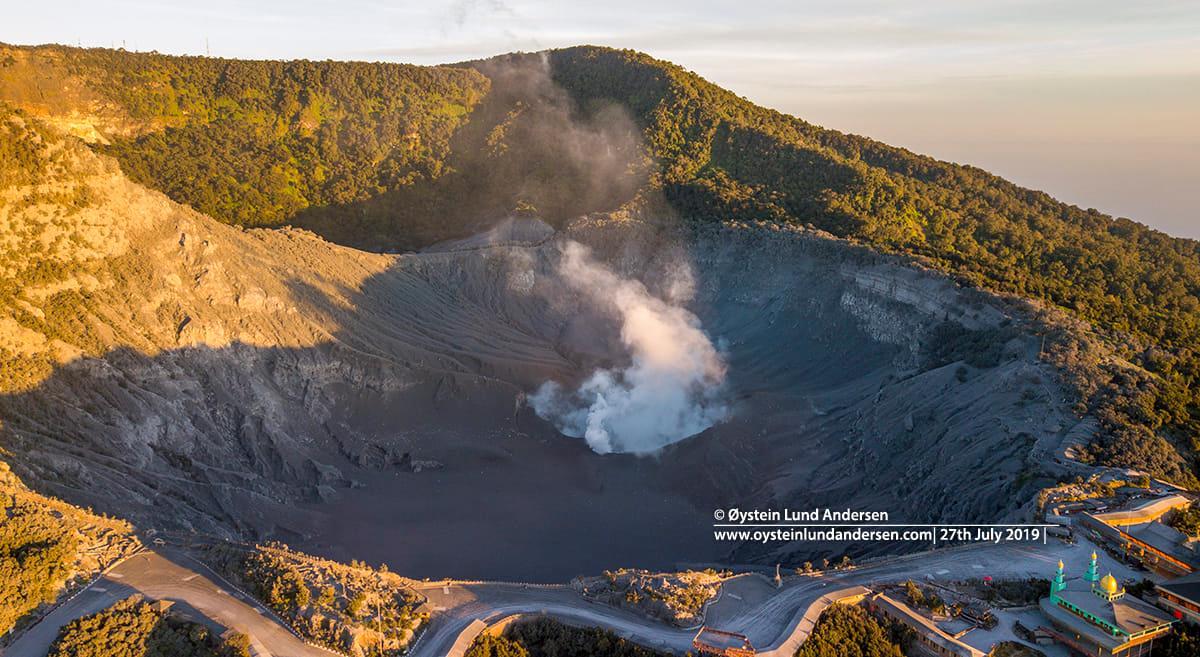
July 27 , 2019.


Indonesia , Tangkuban Parahu :

VOLCANO OBSERVATORY NOTICE FOR AVIATION – VONA.

Issued: July 26 , 2019 .
Volcano: Tangkuban Parahu (263090)
Current Aviation Colour Code: ORANGE
Previous Aviation Colour Code: unassigned
Source: Tangkuban Parahu Volcano Observatory
Notice Number: 2019TPR01
Volcano Location: S 06 deg 46 min 12 sec E 107 deg 36 min 00 sec
Area: West Java, Indonesia
Summit Elevation: 6669 FT (2084 M)


Volcanic Activity Summary:
Eruption with volcanic ash cloud at 08h58 UTC (15h48 local).

Volcanic Cloud Height:
Best estimate of ash-cloud top is around 7309 FT (2284 M) above sea level, may be higher than what can be observed clearly. Source of height data: ground observer.

Other Volcanic Cloud Information:
Ash-cloud moving to northeast and south.

Remarks:
Seismic activity is characterized by continuous volcanic tremor.

Press release on the eruption of Mount Tangkuban Parahu, Friday, July 26, 2019 15:48:18.
Tangkuban Volcano Parahu is an active volcano located in the West Bandung Regency and Subang Regency region of West Java Province. The Tangkuban Parahu eruptions are usually phreatic eruptions from the Kawah Ratu crater. The last eruption occurred on October 6, 2013.

Monitoring data:
Visually, the last month of surface activity was dominated by puffs of smoke from the main crater (Kawah Ratu) from a height of about 15 to 150 meters from the bottom of the crater, from low to medium pressure, from white color and thin to thick intensity. The eruption occurred on July 26, 2019 at 15:48:18, the height of the ash column being observed at ± 200 m above the summit (± 2284 m above sea level). The ash column was observed thick, blackish-gray, leaning to the northeast and south. This eruption is recorded on a seismogram with a maximum amplitude of 50 mm (off scale) and a duration of ± 5 minutes 30 seconds.
At the seismic level, Mount Tangkuban Parahu activity is still dominated by earthquakes that reflect activity at shallow depths. After the eruption, the seismic recordings are dominated by continuous tremors of a maximum amplitude of 2 to 32 mm (dominant of 15 mm). The recorded tremor is related to the release of pressure in the form of puffs that have occurred so far.

In distortion, Tangkuban Parahu experienced moderate local inflation over the last month. The deformation data always indicate that the activity is still not stable.

Geochemically, on July 10, 2019, the content of volcanic gas, H2S and SO2 increased in the area surrounding the Ratu Crater. The volcanic gas content increases on July 13, 2019. Measurements of the concentration of these gases after 12 hours have tended to decrease again quite significantly. The latest gas measurement conducted on July 21, 2019 shows that the gas concentration is still fluctuating and tends to decrease.

Analysis:
Tangkuban Parahu still has the potential to erupt with tremors still registered.
The evaluation of the latest monitoring data indicates that the potential for major eruptions has not been observed.
The activity of Tangkuban Parahu is still in a state that is not yet stable and the activity can change at any time.

Potential dangers:
The most likely threat of danger currently consists of volcanic gas puffs, the concentrations of which fluctuate around the Ratu crater, which may endanger the health and safety of life of visitors, traders and surrounding communities if the trend of Concentrations of volcanic gas remains high. The phreatic eruptions and ash rains around the crater can potentially occur without any obvious volcanic symptoms.

Conclusion:
The activity level of Mount Tangkuban Parahu is still at level 1 (normal), a continuous evaluation is always done to anticipate the increase of the level of threat.

Source : Magma Indonésie ,

Vidéo : Taupik Senjaya


Japan , Asosan :

Minor volcanic eruption observed on Mt. Aso in southwestern Japan.

A small eruption was observed Friday on Mt. Aso in southwestern Japan, spewing smoke as high as 1,600 meters, the weather agency said.
The eruption occurred at 7:57 a.m. at the No. 1 crater of Mt. Aso’s Nakadake, which is 1,506 meters above sea level, according to the Japan Meteorological Agency. There were no immediate reports of injuries.

It was the latest in a series of small-scale eruptions at the volcano in Kumamoto Prefecture since April. No volcanic cinders were detected but the agency warned of volcanic gas.
The agency raised Mt. Aso’s volcanic alert level to 2 on a scale of 1 to 5 in April, urging people not to approach the crater. Local municipalities have restricted entry to areas within 1 kilometer of the crater.

Source : KYODO NEWS.

Photo : Chihiro Fujii , 03 mai 2019.


Italy , Stromboli :

On the evening of 24 July 2019, video footage of the eruption of Stromboli volcano, Aeolian Islands, was acquired. The eruption began on 3 July 2019 with a paroxysmal explosion; subsequently, the eruption changed into continuous Strombolian activity at the summit craters (>750 m above sea level), accompanied by continuous lava overflows extending down the southern portion of the Sciara del Fuoco.


Video footage by Igor Fedele (Mediterranea Trekking of Messina) who kindly granted the use rights to the National Institute of Geophysics and Volcanology (INGV), for scientific, educational and informative purposes.

Source : INGV Vulcani .


Mexico , Colima :

Weekly technical bulletin of the activity of the volcano Colima, Date: July 26, 2019 Bulletin n ° 131

Seismic activity:
Last week, 19 high frequency (HF) events, 1 long period (LP) event, 10 landslides and 18.3 min of low amplitude trenches were automatically recorded. 4 lahars were also recorded in the Montegrande canyon.

Visual observations:
Intermittent emissions of steam and gas mainly from the northeast side of the crater continue to be recorded during the reporting period. Visibility this week allowed to observe the volcano in very short periods. The lahars who descended the Montegrande ravine were also observed using surveillance cameras. When the cloud allowed it, the fixed thermal camera located to the south of the volcano detected thermal anomalies related to the fumaroles activity during the last week.


Geochemistry:
No SO2 flow measurements were performed during the last week.

Remote perception:
No thermal anomalies detected by the MIROVA satellite system were observed during the last week.

Diagnostic :
The volcano maintains an explosive activity of low intensity. The occurrence of these events indicates that the gas probably associated with the moving magma has reached surface levels. This activity can continue and increase in intensity over the following days or weeks. The staff in charge of monitoring the volcano monitors any changes and developments in the activity.

Source : Ucol.

Photo : Protección Civil Jalisco Uepcbj.


Indonesia , Karangetang :

Level of activity at Level III (SIAGA). G. Karangetang (1,784 m above sea level) has started to erupt again since November 25, 2018.
Since yesterday and until this morning, the volcano was clearly visible until it was covered with fog. It was observed that the smoke from the crater was white, of medium to thick intensity and was about 300 meters above the peak.


The seismographs of July 26, 2019 recorded:
63 avalanche earthquakes.
9 earthquakes of explosions.
5 hybrid earthquakes
2 shallow volcanic earthquakes
7 distant tectonic earthquakes.


Recommendations: Since March 26, 2019 at 12:00, the technical recommendations are as follows: –

The public and visitors / tourists should not approach, climb or move in the 2.5 km danger zone around the Kawah Dua (North Crater) and Main Crater (South) peaks. and in the sectoral expansion zone, from Dua Crater at West-Sea in the North, up to 4 km, an area between Kali Batuare and Kali Saboang.
People living around the rivers that come from the summit of Mount Karangetang must be prepared for the potential threat of lahars and sudden floods that may spread to the coast.

VONA: VONA last sent the YELLOW color code, issued November 25, 2018 at 13:32, for volcanic ash emission at an altitude of approximately 2,284 m above sea level or approximately 500 m above the summit, the wind blowing to the east.

Source : PVMBG.

Photos : Wwwexplorekarangetangblogspotcom via Shérine France.

27 Juillet 2019. FR . Indonésie : Tangkuban Parahu , Japon : Asosan , Italie : Stromboli , Mexique : Colima , Indonésie : Karangetang .

27 Juillet 2019.


Indonésie , Tangkuban Parahu :

AVIS D’OBSERVATION DU VOLCAN POUR L’AVIATION – VONA.

Émis: 26 Juillet 2019.
Volcan: Tangkuban Parahu (263090)
Code couleur de l’aviation actuel : ORANGE
Code couleur d’aviation précédent: non attribué
Source: Observatoire du volcan Tangkuban Parahu
Numéro de l’avis: 2019TPR01
Localisation du volcan  : S 06 ° C 46 min 12 sec E 107 ° C 36 min 00 sec
Région :Java occidental, Indonésie
Altitude du sommet: 6669 FT (2084 M).


Résumé de l’activité volcanique:
Eruption avec nuage de cendres volcaniques à 08h58 UTC (15h48 locale).

Hauteur du nuage volcanique:
La meilleure estimation du sommet des nuages de cendres est d’environ 7309 FT (2284 M) au-dessus du niveau de la mer, ce qui peut être plus élevé que ce qui peut être observé clairement. Source des données de hauteur: observateur au sol.

Autres informations sur les nuages volcaniques:
Nuage de cendres se déplaçant vers le Nord – Est et le Sud.

Remarques:
L’activité sismique est caractérisée par des tremors volcaniques continus.

Communiqué de presse sur l’éruption du mont Tangkuban Parahu  , Vendredi, 26 juillet 2019 15:48:18  .

Le volcan Tangkuban Parahu est un volcan actif situé dans la région de West Bandung Regency et Subang Regency, dans la province de Java occidental. Les éruptions du Tangkuban Parahu sont généralement des éruptions phréatiques depuis le cratère Kawah Ratu. La dernière éruption a eu lieu le 6 octobre 2013.  

Données de surveillance:
Visuellement, le dernier mois d’activité en surface a été dominé par des bouffées de fumée depuis le cratère principal (Kawah Ratu) d’une hauteur d’environ 15 à 150 mètres depuis le fond du cratère, de pression faible à moyenne , de couleur blanche et d’intensité fine à épaisse. L’éruption s’est produite le 26 juillet 2019 à 15:48:18  , la hauteur de la colonne de cendres étant observée à ± 200 m au dessus du sommet (± 2284 m au dessus du niveau de la mer). La colonne de cendres a été observée épaisse , de couleur gris noirâtre , penchée au Nord-Est et au Sud. Cette éruption est enregistrée sur un sismogramme d’amplitude maximale de 50 mm (hors échelle) et d’une durée de ± 5 minutes 30 secondes.
Sur le plan sismique, l’activité du mont Tangkuban Parahu est toujours dominée par des tremblements de terre qui reflètent l’ activité à de faibles profondeurs  . Après l’éruption, les enregistrements sismiques sont dominés par des tremors continus d’une amplitude maximale de 2 à 32 mm (dominante de 15 mm). Le tremor enregistré est lié à la libération de pression sous forme de bouffées qui se sont produites jusqu’à présent.

En déformation, le Tangkuban Parahu a connu une inflation locale modérée au cours du dernier mois. Les données de déformation indiquent toujours que l’activité n’est toujours pas stable.

Géochimiquement, le 10 juillet 2019, la teneur en gaz volcanique , en H2S et en SO2 a augmenté dans la zone entourant le cratère Ratu. La teneur en gaz volcanique augmente le 13 juillet 2019. Les mesures de la concentration de ces gaz après 12 h  a eu tendance à baisser à nouveau de manière assez significative. La dernière mesure de gaz effectuée le 21 juillet 2019 montre que la concentration de gaz fluctue toujours et tend à diminuer.

Analyse:
Le Tangkuban Parahu a toujours le potentiel d’entrer en éruption avec des tremors encore enregistrés.
L’évaluation des dernières données de surveillance indique que le potentiel d’éruptions majeures n’a pas été observé.
L’activité du Tangkuban Parahu est toujours dans un état qui n’est pas encore stable et l’ activité peut changer à tout moment.

Dangers potentiels:
La menace de danger la plus probable consiste actuellement en bouffées de gaz volcanique dont les concentrations fluctuent autour du cratère Ratu, ce qui peut mettre en danger la santé et la sécurité de la vie des visiteurs, des commerçants et des communautés environnantes si la tendance des concentrations de gaz volcanique reste élevée . Les éruptions phréatiques et les pluies de cendres autour du cratère peuvent potentiellement se produire sans aucun symptôme volcanique évident.

Conclusion:
Le niveau d’activité du mont Tangkuban Parahu est toujours au niveau 1 (normal), une évaluation continue est toujours effectuée pour anticiper l’augmentation du niveau de menace.

Source : Magma Indonésie ,

Vidéo : Taupik Senjaya


Japon , Asosan :

Éruption volcanique mineure observée sur le mont Aso au Sud-Ouest du Japon.

Une petite éruption a été observée vendredi sur le mont Aso, dans le Sud-Ouest du Japon. Celui ci a émis de la fumée à 1 600 mètres d’altitude, a annoncé l’agence météorologique.
L’éruption s’est produite à 7h57 dans le cratère Nakadake du mont Aso, situé à 1 506 mètres d’altitude. Selon l’Agence météorologique japonaise, il n’y a pas eu de rapports immédiats de blessures.

C’était la dernière d’une série d’éruptions à petite échelle sur le volcan de la préfecture de Kumamoto depuis avril. Aucune cendre volcanique n’a été détectée mais l’agence a alerté sur la présence de gaz volcanique.
L’agence a relevé le niveau d’alerte volcanique du mont Aso à 2 sur une échelle de 1 à 5 en avril, incitant les gens à ne pas s’approcher du cratère. Les municipalités locales ont un accès limité aux zones situées à moins de 1 kilomètre du cratère.

Source : KYODO NEWS.

Photo : Chihiro Fujii , 03 mai 2019.


Italie , Stromboli :

Dans la soirée du 24 juillet 2019, une séquence vidéo de l’éruption du volcan Stromboli, dans les îles Éoliennes, a été acquise. L’éruption a commencé le 3 juillet 2019 avec une explosion paroxystique; par la suite, l’éruption s’est transformée en une activité strombolienne continue au niveau des cratères du sommet (> 750 m au dessus du niveau de la mer), accompagnée par un débordement continu de lave s’étendant dans la partie Sud de la Sciara del Fuoco.


Séquence vidéo d’Igor Fedele (Mediterranea Trekking of Messina) qui a gentiment concédé les droits d’utilisation à l’Institut national de géophysique et de volcanologie (INGV) à des fins scientifiques, éducatives et informatives.

Source : INGV Vulcani .


Mexique , Colima :

Bulletin technique hebdomadaire de l’activité du volcan Colima, Date: 26 juillet 2019 Bulletin n ° 131

Activité sismique:
La semaine dernière, 19 événements de type haute fréquence (HF), 1 événement de type longue période (LP), 10 glissements de terrain et 18,3 min de tremors de faible amplitude ont été automatiquement enregistrés. 4 lahars ont également été enregistrés dans le canyon de Montegrande.  

Observations visuelles:
Des émissions intermittentes de vapeur et de gaz provenant principalement du côté Nord-Est du cratère continuent d’être enregistrées au cours de la période considérée  . La visibilité cette semaine a permis d’observer le volcan dans de très courtes périodes. Les lahars qui ont descendu le ravin de Montegrande  ont également été observés à l’aide de caméras de surveillance. Lorsque le nuage le permettait, la camera thermique fixe située au Sud du volcan a détecté des anomalies thermiques liées à l’ activité des  fumerolles au cours de la dernière semaine.


Géochimie :
Aucune mesure du débit de SO2 n’a été réalisée au cours de la dernière semaine.

Perception à distance :
Aucune anomalie thermique détectée par le système de satellites MIROVA n’a été observée au cours de la semaine dernière.

Diagnostic :
Le volcan maintient une activité explosive de faible intensité. La survenue de ces événements indique que le gaz probablement associé au magma en mouvement a atteint des niveaux de surface. Cette activité peut se poursuivre et augmenter en intensité au cours des jours ou des semaines suivants. Le personnel en charge de la surveillance du volcan surveille les éventuels changements et l’évolution de l’activité.

Source : Ucol.

Photo : Protección Civil Jalisco Uepcbj.


Indonésie , Karangetang :

Niveau d’activité de niveau III (SIAGA).  Le G. Karangetang (1 784 m d’altitude) a recommencé une période d’éruption depuis le 25 novembre 2018.
Depuis hier et jusqu’à ce matin, le volcan était clairement visible jusqu’à ce qu’il soit recouvert de brouillard  . Il a été observé que la fumée issue du cratère était de couleur blanche , d’intensité moyenne à épaisse et s’élevait à environ 300 mètres au dessus du pic.


Les sismographes du 26 juillet 2019 ont enregistrés :
63 tremblements de terre d’avalanches .
9 séismes d’explosions .
5 séismes hybrides
2 séismes volcaniques peu profonds  
7 tremblements de terre tectoniques lointains.


Recommandations: Depuis le 26 mars 2019 à 12h00  , les recommandations techniques sont les suivantes: –
Le public et les visiteurs / touristes ne doivent pas s’approcher , monter et se déplacer dans la zone de prévision de danger qui se situe à 2,5 km autour du sommet du Kawah Dua (cratère Nord) et du cratère principal (Sud) et dans la zone d’expansion sectorielle , du cratère Dua à West-Sea , au Nord, jusqu’à 4 km, zone comprise entre Kali Batuare et Kali Saboang.
Les personnes qui vivent autour des rivières qui proviennent du sommet du mont Karangetang doivent se préparer face à la menace potentielle de lahars et d’inondations soudaines pouvant se répandre sur la côte.

VONA: VONA a envoyé pour la dernière fois le code de couleur JAUNE, publié le 25 novembre 2018 à 13 h 32  , relatif à une émission de cendres volcaniques à une altitude d’environ 2 284 m au dessus du niveau de la mer ou environ 500 m au dessus du sommet, le vent soufflant à l’Est.

Source : PVMBG.

Photos : Wwwexplorekarangetangblogspotcom via Shérine France.