20 April 2019. EN. Japan : Asosan , Chile : Copahue , Colombia : Nevado del Ruiz , Indonesia : Karangetang .

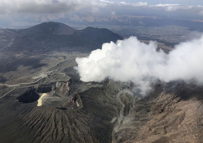
April 20 , 2019 .


Japan , Asosan :

Mt Aso in southwestern Japan erupts again
Apr. 19 01:23 pm .

Mt Aso in Kumamoto Prefecture had a minor eruption Friday following a similar event observed earlier this week, the weather agency said.
The eruption occurred at 8:24 a.m. at the No. 1 Nakadake crater, the same area as Tuesday’s eruption, spewing smoke as high as 400 meters, according to the Japan Meteorological Agency.

There were no immediate reports of injuries, according to local police.

The agency maintained Mt Aso’s volcanic alert level at 2 on a scale of 5. This restricts entry to areas around the crater as even a small volcanic eruption can be dangerous, possibly spewing large flying rocks and causing pyroclastic flows.
The eruption on Tuesday was the first at the volcano since October 2016. Local municipalities have restricted entry to areas within one kilometer of the crater.
« As eruptions continue ahead of a big holiday, it is regrettable that tourists cannot visit the crater on the mountain, » said an official of the city of Aso.

Source : Japantoday.

Photo :  kyodo


Chile , Copahue :

During this period, 159 seismic events classified as volcano-tectonic (VT) type were recorded, associated with fracturing processes of rigid materials. The event with the greatest energy obtained a local magnitude equal to M 2.6 and was located 2.6 km north (N) of the active crater El Agrio, 800m deep.

Similarly, 2 earthquakes associated with fluid dynamics were recorded under the volcanic building, classified as long period type (LP) events, with a maximum reduced displacement value (DRC) of 1.2 cm2. During this period, very long period earthquakes (VLPs, for their acronym in English Very Long Period) were not recorded.

The continuous tremor signal showed oscillations in its amplitude between the values ​​of 0.8 and 1.2 μm / s with dominant frequencies between 1.0 and 3.0 Hz mainly.
The IP cameras installed near the volcano made it possible to determine the absence of emission, simply noting a degassing column on 04 April 2019 from the edge of the active crater (El Agrio) at a maximum height of 80 m, white color .

According to the analysis of the data obtained by four geodetic monitoring stations, small amplitude variations are observed which do not suggest a destabilization of the volcanic system.

Sulfur Dioxide (SO2) emissions recorded by DAS equipment for Mellizas, located 5 km east-northeast of the active crater, had an average value of 434 +. – 105 t / day for the month of March, with a maximum value of 753 t / day reported on April 12th. SO2 emissions are considered moderate if we look at the current state of the volcano.

No thermal warnings were reported in the area associated with the volcanic building during the reporting period, according to the data processed by the mean infrared observation of volcanic activity (MIROVA) (http://www.mirovaweb.it/) and near-real-time thermal monitoring of global hot spots (MODVOLC) (http://modis.higp.hawaii.edu/) .

The seismological parameters showed a decrease in comparison with the previous period, mainly the LP and VLP type seismicity. The volcano-tectonic type seismicity continues despite a decrease in the amount of events and the calculated energy. In relation to the superficial activity, we note the absence of nocturnal incandescence. The satellite images observed on the portal www.planet.com shows that the lake, located in the crater El Agrio continues to drop. The volcanic seismicity recorded during the previous weeks as the variation of the water level of the crater lake could be related to a feed of the magmatic system which would allow the hydrothermal system to be gradually depleted.

According to the characteristics shown during the previous and recent volcanic process by the volcano, it does not rule out the occurrence of an imbalance of the volcanic system, implying the possibility of occurrence of minor explosions that would affect the vicinity of the crater and a increase in surface activity.

Therefore, the alert level is maintained at the level:
YELLOW LEVEL: Changes in the behavior of volcanic activity – Probable time for an eruption: WEEKS / MONTH.

Observation: Est considérée comme zone d’affectation un rayon de 500m autour du cratère .

Source : Sernageomin .


Colombia , Nevado del Ruiz :

Activity of the Nevado del Ruiz volcano, April 18, 2019.

Information:
The COLOMBIAN GEOLOGICAL SERVICE informs the authorities and the community that in recent days, on the Nevado del Ruiz volcano, we continue to record seismic signals (pulses of volcanic tremors and long-period type earthquakes) of low energy. associated with small ash emissions, as reported since last Tuesday in the weekly bulletin. Some of these shows have been seen through the webcams installed in the volcano area (see photographs). In general, the height of the column was variable, between 230 and 1300 m, measured at the top of the volcano, the direction of dispersion being governed by the direction of the wind at the time of emission. It has been highlighted major trends towards North West and South of the volcano.


It is not excluded the possibility of an ash fall on populations located in the direction of the wind regime, nor the recording of new seismic signals associated with emissions of gas and ash.

The level of activity continues in yellow or (III): Changes in the behavior of volcanic activity. The Colombian geological service continues to pay attention to any change of activity and invites to consult the official information that will be provided by the Colombian geological service.

Source : SGC.

Photo : Archive SGC , 12-04-2016.


Indonesia , Karangetang :

Level of activity at Level III (SIAGA). Mount Karangetang (1784 m) has been erupting since 25 November 2018.

Since yesterday and until this morning, the volcano was clearly visible until it was covered with fog. Smoke from the main crater was observed at a maximum height of 200 meters above the crater, with a white color and strong intensity.

The seismographs, on April 19, 2019, recorded:
2 avalanche earthquakes.
5 explosion earthquake.
6 hybrid earthquakes
7 shallow volcanic earthquakes
4 deep volcanic earthquakes
11 distant tectonic earthquakes
Continuous tremor with a dominant amplitude of 0.25 mm.

Recommendation: As of March 26, 2019 at 12:00 WITA, the technical recommendations were as follows:

The public and visitors / tourists should not approach, climb or move in the hazard forecast area which is 2.5 km from the Kawah Dua (North crater) and the main crater (South) peaks. in the sectoral expansion zone of the Dua Crater at West-Sea, in the North, up to 4 km, an area between Kali Batuare and Kali Saboang.

People living around rivers from the summit of Mount Karangetang must be prepared for the potential threat of lahars and sudden floods that can spread to the coast.

VONA: The latest VONA code sent the YELLOW color code, published November 25, 2018 at 13:32 WITA, for volcanic ash emission at an altitude of approximately 2284 m above sea level or approximately 500 m above the summit, the wind blowing in the East.

Source : PVMBG.

Photo : Unknown author.


20 Avril 2019. FR . Japon : Asosan , Chili : Copahue , Colombie : Nevado del Ruiz , Indonésie : Karangetang .

20 Avril 2019 .


Japon , Asosan :

Le Mt Aso , dans le Sud-Ouest du Japon entre en éruption à nouveau
19 avril 13h23.

Le mont Aso, dans la préfecture de Kumamoto, a connu une éruption mineure vendredi à la suite d’un événement similaire observé plus tôt cette semaine, a annoncé l’agence météorologique.
L’éruption s’est produite à 8h24 depuis le cratère de Nakadake, dans la même région que l’éruption de mardi, émettant de la fumée à une hauteur de 400 mètres, selon l’Agence météorologique japonaise.
Selon la police locale, aucun blessé n’a été signalé dans l’immédiat.

L’agence a maintenu le niveau d’alerte volcanique du mont Aso à 2 sur une échelle de 5. Cela limite l’accès aux zones autour du cratère, car même une petite éruption volcanique peut être dangereuse, projetant éventuellement de grosses roches et provoquant des coulées pyroclastiques.
L’éruption de mardi était la première sur le volcan depuis octobre 2016. Les municipalités locales ont restreint l’accès aux zones situées à moins d’un kilomètre du cratère.
« Alors que les éruptions se poursuivent en prévision de grandes vacances, il est regrettable que les touristes ne puissent pas visiter le cratère sur la montagne », a déclaré un responsable de la ville d’Aso.

Source : Japantoday.

Photo :  kyodo


Chili , Copahue :

Durant cette période, 159 événements sismiques classés comme type volcano-tectoniques (VT) ont été enregistrés, associés à des processus de fracturation de matériaux rigides. L’événement ayant la plus grande énergie a obtenu une magnitude locale égale à M 2,6 et a été localisé à 2,6 km au Nord (N) du cratère actif El Agrio, à 800m de profondeur.

De même, 2 séismes associés à la dynamique des fluides ont été enregistrés sous le bâtiment volcanique, classés comme événements de type longue période (LP), avec une valeur de déplacement réduit (DRC) maximale de 1,2 cm2. Durant cette période , il n’a pas été enregistré de séismes de type très longue période (VLP, pour leur acronyme en anglais Very Long Period) .

Le signal de tremor continu a montré des oscillations dans son amplitude entre les valeurs de 0,8 et 1,2 µm/s avec des fréquences dominantes comprises entre 1,0 et 3,0 Hz principalement.

Les caméras IP installées à proximité du volcan ont permis de déterminer l’absence d’émission, notant simplement une colonne de dégazage le 04 Avril 2019 depuis le bord du cratère actif (El Agrio) à une hauteur maximale de 80 m, de couleur  blanche .

Selon l’analyse des données obtenues par quatre stations de surveillance géodésique, on observe des variations de faible amplitude qui ne suggèrent pas une déstabilisation du système volcanique .

Les émissions de dioxyde de soufre ( SO2) enregistré par les équipements de spectrométrie par absorption différentielle ( DOAS) correspondant à la station Mellizas , située à 5 km à l’Est-Nord-Est du cratère actif présentait une valeur moyenne de 434 +/- 105 t/jour pour le mois de Mars , avec une valeur maximale de 753 t/jour rapporté le 12 Avril . Les émissions de SO2 sont considérées comme modérées si on regarde l’état actuel du volcan.

Il n’a pas été rapporté d’ alerte thermique dans la zone associée au bâtiment volcanique au cours de la période considérée, selon les données traitées par l’observation infrarouge moyen. de l’activité volcanique (MIROVA) (http://www.mirovaweb.it/) et de la surveillance thermique en temps quasi réel des points chauds globaux (MODVOLC) (http://modis.higp.hawaii.edu/).

Les paramètres sismologiques ont présenté une diminution en comparaison avec la période antérieure , principalement la sismicité de type LP et VLP  . La sismicité de type volcano-tectonique continue malgré une diminution dans la quantité des évènements et l’énergie calculée . En relation avec l’activité superficielle , on note l’absence d’incandescence nocturne. Les images satellites observé sur le portail www.planet.com montre que le lac , localisé dans le cratère El Agrio continue de baisser de niveau . La sismicité volcanique enregistrée durant les semaines antérieures comme la variation du niveau de l’eau du lac de cratère pourraient etre en relation avec une alimentation du système magmatique lequel permettrait au système hydrothermal de s’épuiser progressivement .

Selon les caractéristiques montrées durant le processus volcanique précédent et récent par le volcan , il n’est pas écarté l’apparition d’un déséquilibre du système volcanique , impliquant la possibilité d’occurrence d’explosions mineures qui affecteraient les environs du cratère et une augmentation de l’activité de surface .

Par conséquent, le niveau d’alerte est maintenu au niveau:
NIVEAU JAUNE: Changements dans le comportement de l’activité volcanique – Temps probable pour une éruption: SEMAINES / MOIS.

Observation: Est considérée comme zone d’affectation un rayon de 500m autour du cratère .

Source : Sernageomin .


Colombie , Nevado del Ruiz :

Activité du volcan Nevado del Ruiz , 18 avril 2019 .

Informations :

Le SERVICE GÉOLOGIQUE COLOMBIEN informe les autorités et la communauté qu’au cours des derniers jours, sur le volcan Nevado del Ruiz, on continue d’enregistrer des signaux sismiques (impulsions de tremors volcaniques et tremblements de terre de type longue période) de faible énergie associés à de petites émissions de cendres, comme rapporté depuis mardi dernier dans le bulletin hebdomadaire. Certaines de ces émissions ont été vues à travers les webcams installées dans la zone du volcan (voir photographies). En général, la hauteur de la colonne a été variable, comprise entre 230 et 1300 m, mesurée au sommet du volcan, la direction de dispersion étant régie par la direction du vent au moment de l’émission. Il a été mis en évidence des tendances majeures vers Nord-Ouest et le Sud du volcan.


Il n’est pas exclu la possibilité d’une chute des cendres sur les populations situées dans la direction du régime des vents, ni l’enregistrement de nouveaux signaux sismiques associés aux émissions de gaz et de cendres.

Le niveau d’activité continue en jaune ou (III): Changements dans le comportement de l’activité volcanique. Le service géologique colombien continue de prêter attention à tout changement d’activité et invite à consulter les informations officielles qui seront fournies par le service géologique colombien.

Source : SGC.

Photo : Archive SGC , 12-04-2016.


Indonésie , Karangetang :

Niveau d’activité de niveau III (SIAGA). Le mont Karangetang (1784 m d’altitude) est entré dans une période d’éruption depuis le 25 novembre 2018.
Depuis hier et jusqu’à ce matin, le volcan était clairement visible jusqu’à ce qu’il soit recouvert de brouillard . La fumée issue du cratère principal a été observée à une hauteur maximale de 200 mètres au dessus du cratère, avec une couleur blanche et une intensité forte.

Les sismographes , le 19 avril 2019 , ont enregistré:
2  tremblements de terre d’avalanche .
5 séisme d’explosion.
6 séismes hybrides
7 tremblements de terre volcaniques peu profonds
4  séismes volcaniques profonds
11 tremblements de terre tectoniques lointains
Tremor continu avec une amplitude dominante de 0,25 mm.

Recommandation: Au 26 mars 2019 à 12h00 WITA, les recommandations techniques étaient les suivantes:
Le public et les visiteurs / touristes ne doivent pas s’approcher , monter et se déplacer dans la zone de prévision de danger qui se situe à 2,5 km du sommet du Kawah Dua (cratère Nord) et du cratère principal (Sud) et dans la zone d’expansion sectorielle du cratère Dua à West-Sea , au Nord, jusqu’à 4 km, zone comprise entre Kali Batuare et Kali Saboang.
Les personnes qui vivent autour des rivières et qui proviennent du sommet du mont Karangetang doivent se préparer face à la menace potentielle de lahars et d’inondations soudaines pouvant se répandre jusqu’à la côte.

VONA: Le dernier code VONA a envoyé le code de couleur JAUNE, publié le 25 novembre 2018 à 13 h 32 WITA, relatif à l’émission de cendres volcaniques à une altitude d’environ 2284 m au dessus du niveau de la mer ou environ 500 m au dessus du sommet, le vent soufflant à l’Est.

Source : PVMBG.

Photo : Auteur inconnu.